Showing 2058 items
matching mountain
-
 Bendigo Historical Society Inc.
Document - BENDIGO EASTER FAIR COLLECTION: 'MARCH TO BIG GOLD MOUNTAIN'
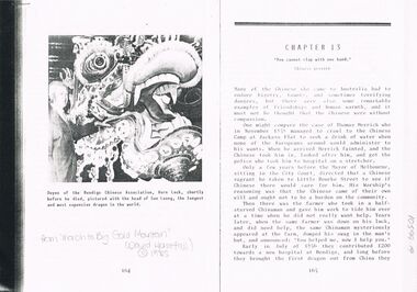
Photocopy of chapter 13 ' You cannot clap with one hand' from book 'March to big Gold Mountain' David Horsfall, 1985 (copyright) 5 pages. Photo on first page of Vern Lock, with the head of Sun Loong. Chapter details involvement of Chinese in the Easter Fair from its earliest inception. Mr. Vern Lock carried the head of the dragon for 40 years.bendigo, chinese, easter fair -
 Falls Creek Historical Society
Photograph - Near Wallace's Hut, Bogong High Plains, 1947- 53
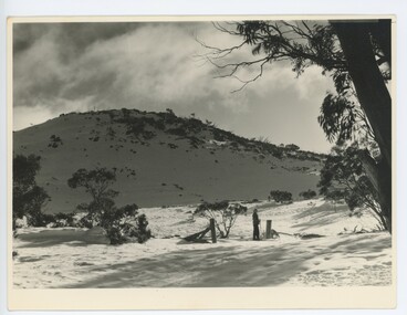
MEYER COLLECTION - FALLS CREEK PHOTOS In 1947 a determined group of like-minded State Electricity Commission (SEC) staff including Ray Meyer, the chief surveyor of the Kiewa Hydro-Electric Scheme, had a common interest that revolved around the skiing potential of the snow-covered high plains which included what is now the resort of Falls Creek. The six SEC employees, Toni St Elmo, Ray Meyer, Jack Minogue, Lloyd Dunn, Adrian Ruffenacht and Dave Gibson (together with their families) banded together to secretly build a 'hut' that was the first ski lodge at Falls Creek. Using a road built in 1930s to gain access to Falls Creek, their hut project was carried out in secret as efforts by other skiers were blocked by H.H.C. Williams – the engineer in charge of the Hydro Scheme. In 1946 Ray Meyer made a trip to the Lands Office in Melbourne. He came away with a 99-year lease on three acres that was ideally suited for a hut designed by Lloyd Dunn. Adrian Ruffenacht (Design Engineer for the KHS) had suggested where the group should build because of easy access to a spring for water. Much of the building material required was scavenged from derelict huts on the high plains. Due to the need for secrecy, the determined group worked on the hut in the evenings and weekends to avoid detection. During the building period the group had met at Echidna Rock (now known as Eagle Rock) where Skippy St Elmo announced, "This is my favourite ‘Skyline’.” And so the first lodge in the area at Falls Creek Ski Resort came into existence. With the development of the International Poma in the 1970s, the Skyline Lodge, which was sited between the ski-lift’s pole one and pole two, was demolished. However, the legacy of Ray Meyer, Toni St Elmo, Jack Minogue, Lloyd Dunn, Adrian Ruffenacht and Dave Gibson and Skyline lives on in the vibrant atmosphere of Falls Creek Resort. The MEYER COLLECTION documents developments on the Kiewa Hydro Scheme and their life at Falls Creek from the mid 1930s to 1960s.These images are significant because they depict aspects of the life of a pioneering family of Falls Creek and the founders of "Skyline", the first lodge at Falls Creek.A black and white image taken near Wallace's Hut.The hut was built in 1889 and is probably the oldest surviving hut on the high plains of north-east Victoria. The State Electricity Commission used the hut from the late 1920s until the early 1940s to collect data on precipitation for possible future hydroelectric works. Toni and Skippy spent their first years on the mountain living in Wallace's Hut.falls creek, bogong high plains, wallace's hut -
 Warrnambool and District Historical Society Inc.
Map - Fire Maps, Region 5 Fire Control Map, 1963
Two fire maps of south west Victoria.1 This is a rectangular piece of linen folded several times to form a packet with the front part covered with a brown card. The cover has a blue and white label. The map has a white base with red and green markings and red and black printing .2 As .1 abovenon-fictionTwo fire maps of south west Victoriafire maps, warrnambool history -
 Halls Gap & Grampians Historical Society
Photograph - B/W, C 1882
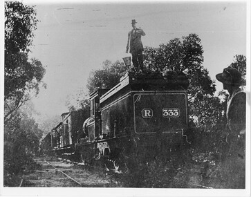
Occasional picnic trains took large groups of visitors to the base of the mountain range & sometimes as far as the quarry. Other journeys terminated at Fyan's Creek station on the south side of Mt. Dryden. Most trips were Sunday School & church outings - some on the annual Good Friday picnic day. spring was also a popular time.Photo shows train at siding. Man standing on engine roof with bucket in hand; woman in right-hand corner looking on; passenger standing at open carriage door. R 333 written on back of engine car. Engine turned back to front.transport, trains -
 Robin Boyd Foundation
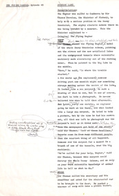
Document - Script, Robin Boyd, The Flying Dogtor. Episode 45 Mystery Lane, 1963
The Flying Dogtor was called by Sir Thomas Persian, the Minister to the Snowy Mountains Scheme. His help was required to solve the problem of a sea-serpent or lake monster that was threatening to harm the scheme. The Dogtor saw the serpent in the distance across the lake. Then he was taken to a shiny new blue submarine. He stepped into it to explore alone into the mysterious lake.The Flying Dogtor" series was broadcast on Australian Television Network (later becoming the Seven Network) between February and April 1964 (see item D254 for schedule).Typewritten, carbon copy, foolscap, 2 pagesMultiple handwritten pencil edits and additions.the flying dogtor, robin boyd, crawford productions, manuscript -
 Robin Boyd Foundation
Document - Script, Robin Boyd, The Flying Dogtor. Episode 50 The Crafty Serpent, 1963
The Flying Dogtor trapped a so-called 'sea serpent' in a tunnel of the Snowy Mountains Scheme and it turned out to be none other than Crafty Carson Carpetbag in disguise. Crafty tricked the Dogtor into opening the bag in which he was caught, and then he knocked over the Dogtor, who hit his head and lay stunned on the floor of the tunnel.The Flying Dogtor" series was broadcast on Australian Television Network (later becoming the Seven Network) between February and April 1964 (see item D254 for schedule).Typewritten, carbon copy, foolscap, 2 pagesHandwritten pencil edits and additions.the flying dogtor, robin boyd, crawford productions, manuscript -
 National Wool Museum
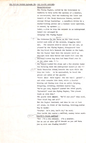
Book, Knitting, Patons Knitting Book no. 748
This book was owned by the late Dr Elizabeth Kerr and was donated to the Museum by the executor of her estate, Margaret Cameron. It was produced by Coats Patons and contains patterns for mens and womens garments knitted in mohair wool. The photographs in this book were taken at 'View Bank', a Welsh mountain pony stud farm owned by Mrs H. Bartramat Heidelberg, Vic.,Patons / BOOK No. 748 / KNITS FOR ALL OCCASIONS / His and hers - a 'V' neck pullover. / Hers only - pullovers, jackets and a skirt / - all in MOHAIR / 2'6 / 25 CENTSknitting handicrafts - history, coats patons (australia) limited, knitting, handicrafts - history -
 Falls Creek Historical Society
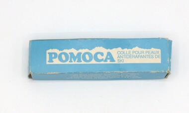
Equipment - Pomoca, c1940s
Pomoca is Swiss based company established by Louis Dufour, a hotelier in Avants, Switzerland. His son Éric developed the production of non-slip skins, and later adhesive skins, as well as many other mountain accessories in1940s.The glue was used by the donor to glue skins on his cross country skis when skiing on the Bogong High Plains.This item is significant as it was an important product used in the ski industry.A small tube of Pomoca skins glue in a blue container with white behind brand section. The box also features instruction in German and French.COLLE POUR PEAUX POMOCA ANTIDERAPANTES DE SKI Translation - Glue for Pomoca anti slip ski skinsski equipment, ski skins, pomoca products -
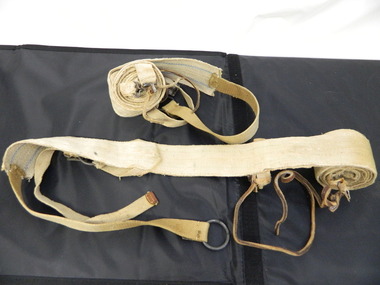 Kiewa Valley Historical Society
Seal Skins Ski Straps / Soles
Seal skin straps and webbing were introduced into the Victorian Alps by European skiers. Enthusiasts travelled to enjoy the snow and to explore the Victorian Alps including the Bogong High Plains. This equipment enabled them to travel over snow without slipping when going up hills. They took the skins off when they wanted to slide down hills. In later years, waxes were used for cross country skiing and then 'fish tail' markings on the back of skis to enable skiers to travel distances up and down mountains. Later developments also included motor transport (replacing horses to get to the snow line) and roads to take skiers to the ski fields and mechanised tows to take skiers up mountains so they could ski down (downhill skiing). Skate skiing has also developed as another form of skiing.Skiers visited the Bogong High Plains during summer and winter to explore and enjoy the High Plains. The equipment used was a forerunner to the variety used today and the different types of skiing done today. Falls Creek was developed during the construction of the Kiewa Electric Hydro Scheme and was influenced by the number of Europeans working on the scheme and their desire to make use of the snow during winter.Each Seal skin has: Seal skin sewn onto one side of a strap of webbing. There is a webbing loop on the front that slips over a small point at the front of the ski. There is a webbing strap attached to the back of the seal skin sole coming over the back of the ski that clips metal fasteners onto a loop of webbing behind the boot.skiing. snow. high plains. seal skins. cross country skiing. alpine sports. -
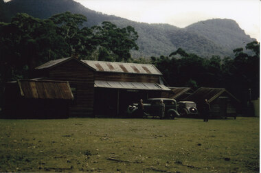
 Kiewa Valley Historical Society
Photo - Bogong Village Township, October 8, 1946
In 1940 Field Headquarters for the Kiewa Scheme were established at Bogong with office, workshop facilities and accommodation for workmen, staff and some families constructed. (There had been a 'tent camp' on this site in 1939 but was destroyed by bushfires) Construction of accommodation continued until 1947. A total of 40 houses plus a hostel for single staff, post office, police station, medical centre and primary school all with water and sewerage and electricity supply. The staff hostel was known as Kiewa House and is now occupied by the Education Department. Lake Guy was named after Mr. L.T. Guy who was the Resident Engineer in charge of construction work and associated activities on the Kiewa area. He held this position from 1939 to November 1946 when he was transferred to Head Office. The Bogong Township was developed firstly as an accommodation centre (base camp) for construction workers employed under the Kiewa Hydroelectric Scheme. Due to the influx of European workers into the Township the beautification of the immediate surrounds (gardens etc.) had a distinct European flavour. This environment has been very beneficial for tourism in later years. At the completion of the scheme, in the 1960's, the village was opened to public/tourism use. Strict environmental control has not allowed for any extensive redevelopment in tourist accommodation and basically restricted it to the accommodation initially built for the construction workers. Activities such a bike riding, snow skiing, restricted horse riding and bush walking on the Alpine plains and mountains are now a viable part of the Kiewa Valley Tourist Industry. The lake is one of the many water storage reservoirs used to supply the power stations their main power to run the huge turbines generating the final product, electricityBlack and white photograph of Bogong Village which appeared in the Herald Sun newspaper on October 8, 1946. Page 13Handwritten on the back - Town of Bogong on a rugged mountain slope above Lake Guy. State Electricity Committee workers on the Kiewa Hydro Electric scheme live here in all electric homes. Stamped on the back - Copyright Not for reproduction Herald Sun Feature Service Melbourne Australiabogong village; lake guy; kiewa hydro electric scheme -
![Mount St. George, Addis Bay / [by] Nicholas Caire, circa 1876](/media/collectors/550653872162f11fb04854aa/items/57833f9fd0cdd1176c6828f5/item-media/57833ffdd0cdd1176c685980/item-fit-380x285.jpg) Kew Historical Society Inc
Kew Historical Society IncPhotograph, Anglo-Australasian Photographic Company, Mount St. George, Addis Bay, c. 1876
Nicholas Caire was born on Guernsey in the Channel Islands in 1837. He arrived in Adelaide with his parents in about 1860. In 1867, following photographic journeys in Gippsland, he opened a studio in Adelaide. From 1870 to 1876 he lived and worked in Talbot in Central Victoria. In 1876 he purchased T. F. Chuck's studios in the Royal Arcade Melbourne. In 1885, following the introduction of dry plate photography, he began a series of landscape series, which were commercially successful. As a photographer, he travelled extensively through Victoria, photographing places few of his contemporaries had previously seen. He died in 1918. Reference: Jack Cato, 'Caire, Nicholas John (1837–1918)', Australian Dictionary of Biography.An original, rare photograph from the series 'Views of Victoria: General Series' by the photographer, Nicholas Caire (1837-1918). The 60 photographs that comprise the series were issued c. 1876 and reinforced a neo-Romantic view of the Australian landscape to which a growing nationalist movement would respond. Nicholas Caire was active as a photographer in Australia from 1858 until his death in 1918. His vision of the Australian bush and pioneer life had a counterpart in the works of Henry Lawson and other nationalist poets, authors and painters.‘Mount St. George, Addis Bay’ : Views of Victoria (General Series) No.56 : Albumen silver photograph | Photo on card with Title and Description on reverse | Mounted 24 x 30 cm; Photo 12 x 17 cm.On Reverse: ‘Addis Bay is situated to the north-east of Appollo Bay, and very near Cape Patten. This mountain is 6,000 feet high, and commands one of the finest views on the Cape Otway Ranges. The ascent is a somewhat difficult one, but visitors to this locality not unfrequently make this a favourite outing.’nicholas caire (1837-1918), landscape photography -
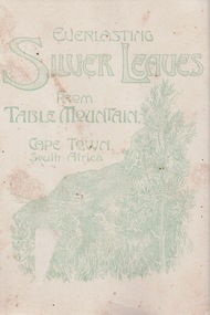 Lara RSL Sub Branch
Picture Postcard Booklet, Cape Town South Africa
This card is part of the McIntyre collection from three sons, J.L. McIntyre (founding member of Lara RSL Sub Branch WW1; J. W. McIntyre WW1 and T.G. McIntyre WW2. Jim McIntyre picked this card up while on leave in Cape Town, South AfricaA card sent home to family from WW1 Anzac serving in the AIFOn cover (see image) is written Everlasting Silver Leaves from Table Mountain Cape Town South Africa On second page (see image) is a photo of Strand Street, Cape Town On third page (see image) are three leaves with a picture of flowers, a hand and sign 'Remember Me' On back page (see image) is writing - Cape Town 12/1/17 To Florrie From Jim silver leaves, table mountain, cape town, south africa, ww1, world war 1, australian army, aif, mcintyre, strand street -
 Halls Gap & Grampians Historical Society
Photograph - Coloured
The main building and chalets were built by E. C. Mitchell of Stawell. He was given a 99 year lease by the shire to build his holiday house at the site of Borough Huts. David and May Mitchell took over ownership of the house and chalets. The women in the photo are May and Isabel Mitchell and the man is David Mitchell. The chalets were called "Flappers Roost", "Bower of Innocence" and "Last Resort". The two copies of the photo are taken from slight closer in and are not as clear and do not show the entire third chalet.The photo shows a collection of old buildings. Two women are standing in front of a car and a man is standing a short distance from them. A second car is parked between the main building and the huts. The building to the far right of the photo is painted in a cream colour and has a tin chimney. The other buildings are three small huts or chalets. Gum trees and a mountain range can be seen directly behind the buildings.buildings, houses -
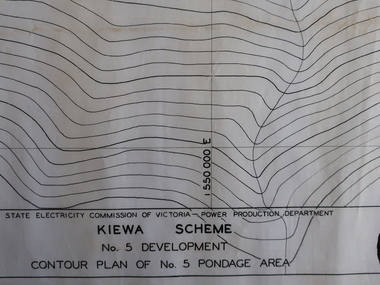 Kiewa Valley Historical Society
Plans - Kiewa Works Area and Environs
State Electricity Commission of Victoria constructed the Kiewa Hydro Electric Scheme from the late 1940s to 1961. These plans were used during the construction.Plans and Maps were used during the construction of the Kiewa Hydro Electric SchemeTransparent with blue tinge plans/maps created by the SECV during the construction of the Kiewa Hydro Electric Scheme. 1. Kiewa Scheme No 5 Development Contour Plan of No 5 Pondage Area 2. Mt Beauty Township 3. Kiewa Scheme No 1 Development - McKay Creek Area, Construction Layout 4. Kiewa Works and Environs 5. North Eastern Victoria and Adjoining Snowy Mountains Regionsecv, kiewa hydro electric scheme plans -
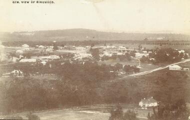 Ringwood and District Historical Society
Photograph, View of Ringwood in 1912 taken from Loughnan's Hill
Black and white photograph looking across valley with small settlement. Mountains in background. (2 postcard copies and 2 enlargements). House in right foreground is in what is known now as Wildwood Grove. The dirt track above is Ringwood St. Field above is the football field with diagonal track coming out at Melbourne Street, later Eastland shopping complex. House on left is in Adelaide Street. Warrandyte Road is above it."Typed on back of one enlargement, "Copied from a postcard mailed in Ringwood, 1912, copied 1959. House in right foreground is in what is known now as Wildwood Grove. The dirt track above is Ringwood St. Field above is the present football field with diagonal track coming out at Melbourne Street. House on left is in Adelaide Street. Warrandyte Road is above it." House bottom RH side was still there in 1970 in Wildwood Grove (off Ringwood St). Ringwood Street lower centre to RH side. Field above Ringwood Street is the football field with diag. walk coming out at Melbourne Street. House on LH side in Adelaide Street. Warrandyte above it. Steam at LH from Bently's Steam Joinery at corner Main Street and Warrandyte Road. -
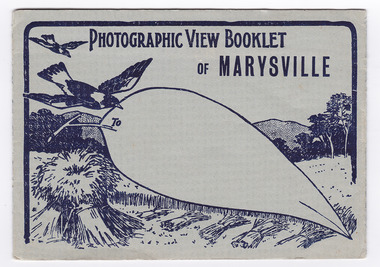 Marysville & District Historical Society
Postcard (item) - Black and white photographs, Barton Bros, Photographic View Booklet of MARYSVILLE, 1923-1963
A series of nine black and white photographs of scenic attractions taken in and around Marysville in Victoria that was published by the Barton Bros, Marysville and printed by Valentines Publishing Co as a souvenir of Marysville.A series of black and white photographs of scenic attractions taken in and around Marysville in Victoria that was published by the Barton Bros, Marysville and printed by Valentines Publishing Co as a souvenir of Marysville. Thomas Barton was one of the earliest settlers in Marysville and with 16 children and numerous descendants, the name of Barton is synonymous with Marysville. Thomas John Barton, along with his business partner, Ewen Hugh Cameron, opened a butcher/abattoirs in Marysville in 1864. This was the first shop in Marysville. They supplied meat and other items to the miners along the Woods Point road. Thomas Barton was an active community member and was a key organiser in setting up the school in Marysville in 1870. After Thomas' death in 1911, his sons Fred and Frank took over the family business and renamed it Barton Bros. To From Published by BARTON BROS., Marysvillemarysville, victoria, barton bros, acheron way (image 1), keppel's falls (image 2), cumberland falls (image 3), stevenson falls (image 4), taggerty river (image 5), mount margaret (image 6), mount gordan (image 7), nicholl's lookout (image 8), the old ford (image 9), postcard, valentine publishing co, souvenir, thomas barton, francis adam barton, frederick barton, ewen hugh cameron -
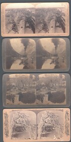 Bendigo Historical Society Inc.
Photograph - WES HARRY COLLECTION: 4 STEREOGRAPHIC CARDS, 1905 ?
Four stereographic cards depicting various scenes and locations : (a) Gudvangen's outlook over the Naerofjord, where the sea reaches far in among the mountains, Norway , (b) Royal Munster Fusiliers fighting from behind the redoubt at Honey Nest Kloof (Feb 16th) South Africa , (c) Winter scene at Niagara Falls , (d) Ancient Olive trees, Garden of Gethsemane, Jerusalem (Mathew xxvi, 36 - 56).place, various, underwood publishers, american series -
 Bendigo Historical Society Inc.
Newspaper - LYDIA CHANCELLOR COLLECTION: TREES
A box with a picture of trees on the front.(Writing on back of box states 'Trees of Williamsburg U.S.A. by Michael Frome .This tree grew when Jesus was born'(from Look Learn 11.8.62 article .Mountain lake in Alberta Canada .Strand on the green near London ). It contains pictures of, and articles about, trees. Sources include, 'The Sun,' 'Illustrated London News,' 'The Australian Women's Weekly' and 'The Australasian Post.' 1937 - 1968.TREESsciences, general, trees, lydia chancellor, collection, natural history, place, trees, botany, sciences -
 Whitehorse Historical Society Inc.
Textile - Tape Lace in large illustrated envelope
White tape lace on a card which is enclosed in a large illustrated envelope. The mid 19th century 'Renaissance Lace' is wound around cardboard which is in the large envelope. The lace depicts five petaled daisies with an eyelet on each side. The envelope is illustrated with drawings of snowdrops. It opens on the front with small snowdrops drawn around the square opening. On the right hand top corner there is a drawing of mountains with a village in the valley.'Snow-Bleach Embroidery' Man. in Switzerland. Guaranteed to retain its Snow-Whiteness. 'All Cotton' No. 83177 20yds E600handcrafts, lacemaking, documents, envelopes -
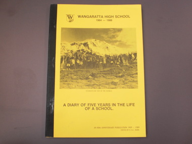 Wangaratta High School
WHS 80th Anniversary History Book, A Diary of Five Years in the Life of a School, 1989
Marks the 80th Anniversary of Wangaratta High Schools educational service since opening in 1909 under the name Wangaratta Agricultural High School.A4 stapled book with black tape enclosing spine. Black and white cover printed on yellow paper feature the name of the school accompanied by the school logo and the dates 1984-1988. Below this is a black and white photo of Wangaratta High school students on an outdoor excursion simultaneously jumping for the photograph in front of a snowy mountain, with the caption 'students on top of the world'. Below this is the title and in the lower right corner is the publication information.WANGARATTA HIGH SCHOOL 1984-1988 students on top of the world A DIARY OF FIVE YEARS IN THE LIFE OF A SCHOOL. an 80th Anniversary publication 1909-1989 edited by D. & L. Barr -
 Bendigo Historical Society Inc.
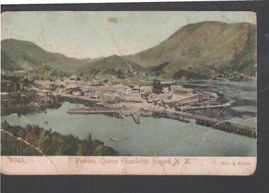
Postcard - JOHN JONES COLLECTION: POSTCARD OF PICTON
Coloured postcard of Picton, Queen Charlotte Sound, N.Z. Card shows a town beside the water with mountains in the background. Written on the back: Written to Nell from Jack. He tells her he is well and when he expects to get to Greymouth and said he didn't have time to write from Wellington so he wrote from Picton instead. Dated May 16/08.Muir & Moodie Dunedin N.Z.place, landscape view, picton nz, john jones collection - picton, muir & moodie dunedin nz -
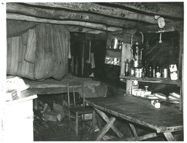 Falls Creek Historical Society
Photograph - Inside Wallace's Hut, c1968
MEYER COLLECTION - FALLS CREEK PHOTOS In 1947 a determined group of like-minded State Electricity Commission (SEC) staff including Ray Meyer, the chief surveyor of the Kiewa Hydro-Electric Scheme, had a common interest that revolved around the skiing potential of the snow-covered high plains which included what is now the resort of Falls Creek. The six SEC employees, Toni St Elmo, Ray Meyer, Jack Minogue, Lloyd Dunn, Adrian Ruffenacht and Dave Gibson (together with their families) banded together to secretly build a 'hut' that was the first ski lodge at Falls Creek. Using a road built in 1930s to gain access to Falls Creek, their hut project was carried out in secret as efforts by other skiers were blocked by H.H.C. Williams – the engineer in charge of the Hydro Scheme. In 1946 Ray Meyer made a trip to the Lands Office in Melbourne. He came away with a 99-year lease on three acres that was ideally suited for a hut designed by Lloyd Dunn. Adrian Ruffenacht (Design Engineer for the KHS) had suggested where the group should build because of easy access to a spring for water. Much of the building material required was scavenged from derelict huts on the high plains. Due to the need for secrecy, the determined group worked on the hut in the evenings and weekends to avoid detection. During the building period the group had met at Echidna Rock (now known as Eagle Rock) where Skippy St Elmo announced, "This is my favourite ‘Skyline’.” And so the first lodge in the area at Falls Creek Ski Resort came into existence. With the development of the International Poma in the 1970s, the Skyline Lodge, which was sited between the ski-lift’s pole one and pole two, was demolished. However, the legacy of Ray Meyer, Toni St Elmo, Jack Minogue, Lloyd Dunn, Adrian Ruffenacht and Dave Gibson and Skyline lives on in the vibrant atmosphere of Falls Creek Resort. The MEYER COLLECTION documents developments on the Kiewa Hydro Scheme and their life at Falls Creek from the mid 1930s to 1960s.This image is significant because Wallace's Hut is a heritage listed building which has provided shelter to cattlemen and skier on the High Plains since 1889.A black and white photo taken by John Meyer inside Wallace's Hut. The hut was built in 1889 and is probably the oldest surviving hut on the high plains of north-east Victoria. The State Electricity Commission used the hut from the late 1920s until the early 1940s to collect data on precipitation for possible future hydroelectric works. Toni and Skippy spent their first years on the mountain living in Wallace's Hut. falls creek, victorian snowfields, joan meyer, diamantina hut -
 Wodonga & District Historical Society Inc
Map - Australia Shewing the Tracks of the Late Explorers, c1865
Charles George Eastland Platts arrived in South Australia on 22 March 1839, and soon after established his business in Adelaide. He became Adelaide’s first bookseller. It was known as Platts’ Library but was also a bookshop and stationer. His business was also used as a postal receiving house. Platts died on 14 November 1871. Boyle Travers Finniss (18 August 1807 – 24 December 1893) had an early career in the British Military before selling off his commission in 1835. He was appointed assistant surveyor to Colonel William Light in South Australia. He then had several roles in public service. Finniss was the first premier and Chief Secretary South Australia, serving from 24 October 1856 to 20 August 1857. In 1864 he was appointed as the Government Resident of the Northern Territory. He was filling this role at the time when the map was produced and is acknowledged on the map.This is a very early map documenting the exploration and opening up of Australia.Map of Australia and part of Indonesia. Part coloured with tracks of 15 explorers including Eyre, Stuart, Leichhardt and Burke and Wills with notes and some details of latitude and longitude. Relief relating to the major mountain ranges is indicated. At the bottom of the map is a key to the explorers and a list of the counties in the different states. Top left side of map has small sketch of the Platts (publisher) building at the corner of King William Street.Map of Australia shewing the tracks of late explorers into the interior and across the continent together with their discoveries map/ projected, compiled and drawn by O.W.O. Bennett Most Respectfully Dedicated to LIEUT. COL. BOYLE TRAVERS FINISS Government Resident of the Northern Territory of SOUTH AUSTRALIAexplorers -- australia -- maps, rare maps australia -
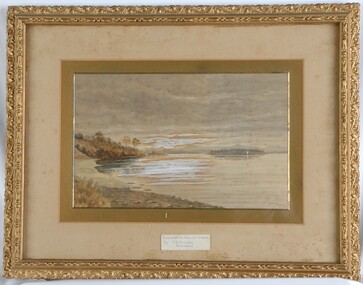 Glenelg Shire Council Cultural Collection
Painting, A S Murray, Dunrobin, n.d
CEMA Art Collection Previously located in History HouseA large body of water with a shore line in the foreground on the left. Depicted in shades of grey, the calm water features a patch of white in the centre - reflection. In the background to the right, is a distant view of a small patch of land covered in trees. Behind the land is an out of focus view of mountains in the distance. The top half of the work features a grey cloudy sky. The work has a gilded ornate frame with cardboard and gold mounts and glass.Front: A.S. Murray Label attached to glass front: Presented to Council in 1984 by A.S. Murray Dunrobin Back: W. Hamer 189 Sturt Street Ballarat VICTORIA BUILDINGS, OPPOSITE CITY FIRE BRIGADElandscape -
 Eltham District Historical Society Inc
Document - Property Binder, 953 Main Road, Eltham
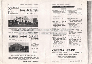
Broadbent's Guide "Melbourne's Mountains" no date, pp20-21: Eltham Motor Garage and Celina Cafe. Business card: Eltham Bookshop, Meera Govil. Invitation; An evening with Robert Dessaix, Eltrham Bookshop, 7 Dec 1998 Newspaper advertisement: Diamond Valley Leader, 3 November 2004, Miko. Miko Customer Loyalty Card Nov. 2004main road, eltham, property, shops, businesses, eltham motor garage, celina cafe, eltham bookshop, meera govil, miko beautiful child -
 Robin Boyd Foundation
Document - Script, Robin Boyd, The Flying Dogtor. Episode 47 Night Watch, 1963
The Flying Dogtor, called by the Government to Canberra to help solve the mystery of a monster or sea-serpent, that seemed to be threatening the Snowy Mountain Scheme, spent a night in a tunnel. He was waiting for the monster to appear, so that he could try to find out where it came from and what it wanted. Suddenly, he heard heavy breathing close behind him in the darkness.The Flying Dogtor" series was broadcast on Australian Television Network (later becoming the Seven Network) between February and April 1964 (see item D254 for schedule).Typewritten, carbon copy, foolscap, 2 pagesHandwritten pencil edits and additions.the flying dogtor, robin boyd, crawford productions, manuscript -
 Orbost & District Historical Society
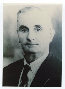
black and white photograph, C1947
This is a photograph of Councillor Henry Ingram who represented North Riding from 1927 - 1947 on the Orbost Shire Council. Harry Ingram delivered milk, bread, groceries and meat to towns between Delegate and Orbost with his eldest son. The pair generally drove a four wheeled wagon pulled by five horses along a hand carved winding track through the mountains.This item is associated with the Orbost Shire Council. The shire covered an area of 9,347 square kilometres and existed from 1892 until 1994 when it became part of the East Gippsland Shire Council.A black / white head and shoulders portrait photograph of a man in a suit.There is also a framed photograph.on back - " Cr H. Ingram J.P. , North Riding 1929-1947"ingram-henry orbost-shire-council -
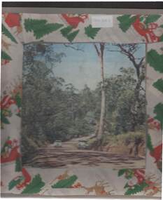
 Marysville & District Historical Society
Flyer (item) - Information Flyer, Forests Commission, Victoria, Cumberland Scenic Reserve, 1918-1983
An information flyer that was produced as a guide to the Cumberland Scenic Reserve by the Forests Commission of Victoria. The Forests Commission Victoria (FCV) was the main government authority responsible for management and protection of State forests in Victoria, Australia between 1918 and 1983. The Commission was responsible for ″forest policy, prevention and suppression of bushfires, issuing leases and licences, planting and thinning of forests, the development of plantations, reforestation, nurseries, forestry education, the development of commercial timber harvesting and marketing of produce, building and maintaining forest roads, provision of recreation facilities, protection of water, soils and wildlife, forest research and making recommendations on the acquisition or alienation of land for forest purposes″. The Cumberland Scenic Reserve is set in the heart of the mountain forests of Victoria and is 16km east of Marysville on the Cumberland Road. This reserve forms part of the catchment of Armstrong Creek, a tributary of the Yarra River which provides water for the Melbourne area. The reserve is a prime mountain ash area in which is set the old Cambarville sawmill and village site.An information flyer that was produced as a guide to the Cumberland Scenic Reserve by the Forests Commission of Victoria. 423Aforests commission victoria, cumberland scenic reserve, marysville, victoria, cambarville, the big tree, cora-lyn falls, barton's lookout, cumberland falls, sovereign view, armstrong creek, yarra river, mountain ash -
 Ringwood and District Historical Society
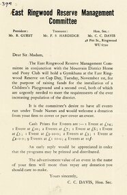
Pamphlet, East Ringwood Reserve Management Committee
An A5 flyer from the East Ringwood Reserve Management Committee in conjunction the Mountain District Horse and Pony Club announcing a Gymkhana at the East Ringwood Reserve on Cub Day, Tuesday November 1st for raising funds for the installation of a Children's Playground and second oval. Looking fo donations to cover or part cover the event. President: Mr. R. Guest. Treasurer: Mr F.S. Hardidge. Hon. Sec.: Mr C.C. Davis. -
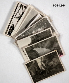 Bendigo Military Museum
Photograph - PHOTOGRAPHS, RABAUL
Series of photographs taken near Rabaul in 1941 during WW2, of the Volcano Matupi and other local scenes. Taken by Ern King who died on Rabaul. Collection of 9 photos of Rabaul 1941. All Black and white with white borders. 1. A blow hole at Matupi with smoke coming out. 2. Snow on side of mountain. 3. A stump on side of Matupi. 4. & 5.Photos of Albino camp with soldiers watching natives. 6. Photo of the Volcano at Matupi. 7. Photo on top of Volcano at Matupi. 8. Photo of natives climbing a coconut tree. 9. Photo of a crocodile.On the back of each is written the following; 1. A blow hole at Matupi. 2. Bed (?) of Matupi 1941. 3. A stump on side of Matupi. 4. & 5.Photos of Albino camp 1941. E.G. King 6. Matupi from the bottom 1941. 7.Near the top of Matupi. 8. Getting a few coconuts for use. 9. A snap of a crocodile.rabaul 1941, volcano, matupi, ww2, e. g. king