Showing 2436 items matching "orchard"
-
 Eltham District Historical Society Inc
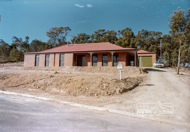
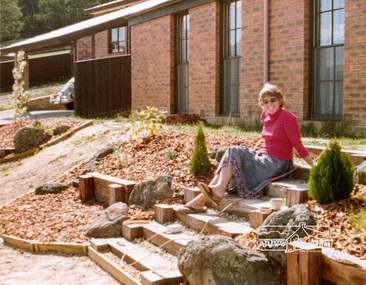
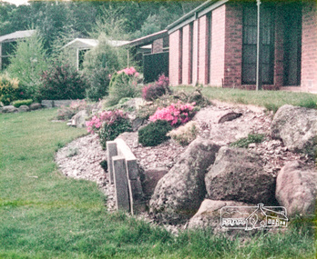
Photograph, 14 Stokes Place, Eltham, April 1980, 1980
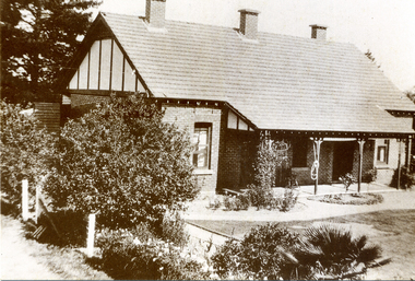
14 Stokes Place was the home of Peter and Carla Vermey. The land was purchased in May 1979 and the home built by Peter and Carla Vermey after the developer, Macquarie Builders went bankrupt. Sold October 2017 by Morrison and Kleeman Real Estate. Stokes Place was part of the Stokes Orchard Estate which was developed from the break-up of the the orchard owned by Frank Stokes who lived on the northeast corner of Nyora Road and Eucalyptus Road. His daughter Beryl advised that the Shire had levied a rate assessment on individual parcels of land within the orchard which became unaffordable resulting in its sub-division and sell off. The Stokes Orchard Estate was developed by Macquarie Builders in two stages starting with stage 1 in 1976. Stokes Place was part of Stage 2 in 1979. The Estate was bounded between Nyora Road, Eucalyptus Road, Diosma Road and Stokes Place. The original orchard only just reached the left most portions of Stokes Place and did not go fully up to Diosma, rather to just beyond the extant of Stokes Place. Stokes Place was known within the family as "The Oats" as that is where they grew oats. Frank Stokes moved to Eltham c.1945 after visiting Harold Bird to view his orchard, located diagonally opposite Stokes Orchard from the intersection of Eucalyptus Road, Pitt Street and Nyora Road. It was on Harold Bird's recommendation that Frank purchased the land.The Stokes Orchard Estate collection is typical of housing developments of the late 1970s and 1980s. It was one of the earliest estates in Eltham following the nearby Woodridge Estate development.Digital fileScanned from a print contained in owner's photo album (81 prints in total digitised)stokes place, eltham, stokes orchard, stokes orchard estate, streets, houses, peter and carla vermey -
 Eltham District Historical Society Inc
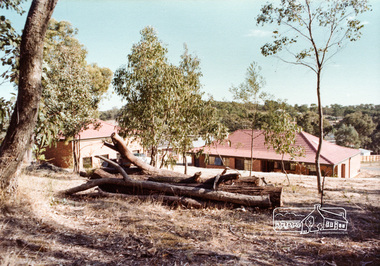
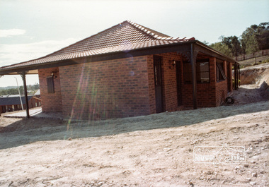
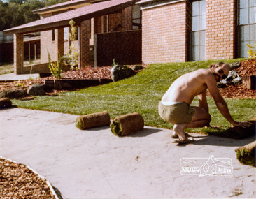
Photograph, 14 Stokes Place, Eltham, April 1980, 1980
14 Stokes Place was the home of Peter and Carla Vermey. The land was purchased in May 1979 and the home built by Peter and Carla Vermey after the developer, Macquarie Builders went bankrupt. Sold October 2017 by Morrison and Kleeman Real Estate. Stokes Place was part of the Stokes Orchard Estate which was developed from the break-up of the the orchard owned by Frank Stokes who lived on the northeast corner of Nyora Road and Eucalyptus Road. His daughter Beryl advised that the Shire had levied a rate assessment on individual parcels of land within the orchard which became unaffordable resulting in its sub-division and sell off. The Stokes Orchard Estate was developed by Macquarie Builders in two stages starting with stage 1 in 1976. Stokes Place was part of Stage 2 in 1979. The Estate was bounded between Nyora Road, Eucalyptus Road, Diosma Road and Stokes Place. The original orchard only just reached the left most portions of Stokes Place and did not go fully up to Diosma, rather to just beyond the extant of Stokes Place. Stokes Place was known within the family as "The Oats" as that is where they grew oats. Frank Stokes moved to Eltham c.1945 after visiting Harold Bird to view his orchard, located diagonally opposite Stokes Orchard from the intersection of Eucalyptus Road, Pitt Street and Nyora Road. It was on Harold Bird's recommendation that Frank purchased the land.The Stokes Orchard Estate collection is typical of housing developments of the late 1970s and 1980s. It was one of the earliest estates in Eltham following the nearby Woodridge Estate development.Digital fileScanned from a print contained in owner's photo album (81 prints in total digitised)stokes place, eltham, stokes orchard, stokes orchard estate, streets, houses, peter and carla vermey -
 Eltham District Historical Society Inc
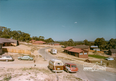
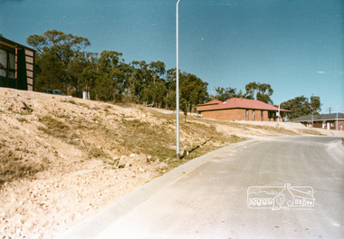
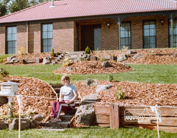
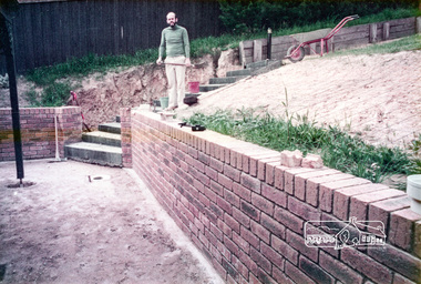
Photograph, Stokes Place, Eltham, April 1980; viewed from near no. 10 looking southeast, 1980
14 Stokes Place was the home of Peter and Carla Vermey. The land was purchased in May 1979 and the home built by Peter and Carla Vermey after the developer, Macquarie Builders went bankrupt. Sold October 2017 by Morrison and Kleeman Real Estate. Stokes Place was part of the Stokes Orchard Estate which was developed from the break-up of the the orchard owned by Frank Stokes who lived on the northeast corner of Nyora Road and Eucalyptus Road. His daughter Beryl advised that the Shire had levied a rate assessment on individual parcels of land within the orchard which became unaffordable resulting in its sub-division and sell off. The Stokes Orchard Estate was developed by Macquarie Builders in two stages starting with stage 1 in 1976. Stokes Place was part of Stage 2 in 1979. The Estate was bounded between Nyora Road, Eucalyptus Road, Diosma Road and Stokes Place. The original orchard only just reached the left most portions of Stokes Place and did not go fully up to Diosma, rather to just beyond the extant of Stokes Place. Stokes Place was known within the family as "The Oats" as that is where they grew oats. Frank Stokes moved to Eltham c.1945 after visiting Harold Bird to view his orchard, located diagonally opposite Stokes Orchard from the intersection of Eucalyptus Road, Pitt Street and Nyora Road. It was on Harold Bird's recommendation that Frank purchased the land.The Stokes Orchard Estate collection is typical of housing developments of the late 1970s and 1980s. It was one of the earliest estates in Eltham following the nearby Woodridge Estate development.Digital fileScanned from a print contained in owner's photo album (81 prints in total digitised)stokes place, eltham, stokes orchard, stokes orchard estate, streets, houses, peter and carla vermey -
 Eltham District Historical Society Inc
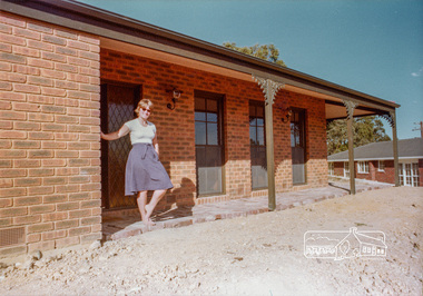
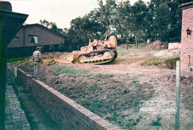
Photograph, 14 Stokes Place, Eltham, April 1980, 1980
14 Stokes Place was the home of Peter and Carla Vermey. The land was purchased in May 1979 and the home built by Peter and Carla Vermey after the developer, Macquarie Builders went bankrupt. Sold October 2017 by Morrison and Kleeman Real Estate. Stokes Place was part of the Stokes Orchard Estate which was developed from the break-up of the the orchard owned by Frank Stokes who lived on the northeast corner of Nyora Road and Eucalyptus Road. His daughter Beryl advised that the Shire had levied a rate assessment on individual parcels of land within the orchard which became unaffordable resulting in its sub-division and sell off. The Stokes Orchard Estate was developed by Macquarie Builders in two stages starting with stage 1 in 1976. Stokes Place was part of Stage 2 in 1979. The Estate was bounded between Nyora Road, Eucalyptus Road, Diosma Road and Stokes Place. The original orchard only just reached the left most portions of Stokes Place and did not go fully up to Diosma, rather to just beyond the extant of Stokes Place. Stokes Place was known within the family as "The Oats" as that is where they grew oats. Frank Stokes moved to Eltham c.1945 after visiting Harold Bird to view his orchard, located diagonally opposite Stokes Orchard from the intersection of Eucalyptus Road, Pitt Street and Nyora Road. It was on Harold Bird's recommendation that Frank purchased the land.The Stokes Orchard Estate collection is typical of housing developments of the late 1970s and 1980s. It was one of the earliest estates in Eltham following the nearby Woodridge Estate development.Digital fileScanned from a print contained in owner's photo album (81 prints in total digitised)stokes place, eltham, stokes orchard, stokes orchard estate, streets, houses, peter and carla vermey -
 Eltham District Historical Society Inc
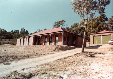
Photograph, 14 Stokes Place, Eltham, 1982, 1980
14 Stokes Place was the home of Peter and Carla Vermey. The land was purchased in May 1979 and the home built by Peter and Carla Vermey after the developer, Macquarie Builders went bankrupt. Sold October 2017 by Morrison and Kleeman Real Estate. Stokes Place was part of the Stokes Orchard Estate which was developed from the break-up of the the orchard owned by Frank Stokes who lived on the northeast corner of Nyora Road and Eucalyptus Road. His daughter Beryl advised that the Shire had levied a rate assessment on individual parcels of land within the orchard which became unaffordable resulting in its sub-division and sell off. The Stokes Orchard Estate was developed by Macquarie Builders in two stages starting with stage 1 in 1976. Stokes Place was part of Stage 2 in 1979. The Estate was bounded between Nyora Road, Eucalyptus Road, Diosma Road and Stokes Place. The original orchard only just reached the left most portions of Stokes Place and did not go fully up to Diosma, rather to just beyond the extant of Stokes Place. Stokes Place was known within the family as "The Oats" as that is where they grew oats. Frank Stokes moved to Eltham c.1945 after visiting Harold Bird to view his orchard, located diagonally opposite Stokes Orchard from the intersection of Eucalyptus Road, Pitt Street and Nyora Road. It was on Harold Bird's recommendation that Frank purchased the land.The Stokes Orchard Estate collection is typical of housing developments of the late 1970s and 1980s. It was one of the earliest estates in Eltham following the nearby Woodridge Estate development.Digital fileScanned from a print contained in owner's photo album (81 prints in total digitised)stokes place, eltham, stokes orchard, stokes orchard estate, streets, houses, peter and carla vermey -
 Eltham District Historical Society Inc
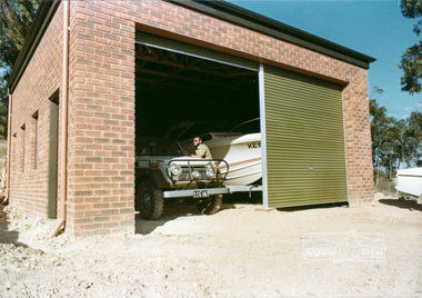
Photograph, 14 Stokes Place, Eltham, October 1983, 1980
14 Stokes Place was the home of Peter and Carla Vermey. The land was purchased in May 1979 and the home built by Peter and Carla Vermey after the developer, Macquarie Builders went bankrupt. Sold October 2017 by Morrison and Kleeman Real Estate. Stokes Place was part of the Stokes Orchard Estate which was developed from the break-up of the the orchard owned by Frank Stokes who lived on the northeast corner of Nyora Road and Eucalyptus Road. His daughter Beryl advised that the Shire had levied a rate assessment on individual parcels of land within the orchard which became unaffordable resulting in its sub-division and sell off. The Stokes Orchard Estate was developed by Macquarie Builders in two stages starting with stage 1 in 1976. Stokes Place was part of Stage 2 in 1979. The Estate was bounded between Nyora Road, Eucalyptus Road, Diosma Road and Stokes Place. The original orchard only just reached the left most portions of Stokes Place and did not go fully up to Diosma, rather to just beyond the extant of Stokes Place. Stokes Place was known within the family as "The Oats" as that is where they grew oats. Frank Stokes moved to Eltham c.1945 after visiting Harold Bird to view his orchard, located diagonally opposite Stokes Orchard from the intersection of Eucalyptus Road, Pitt Street and Nyora Road. It was on Harold Bird's recommendation that Frank purchased the land.The Stokes Orchard Estate collection is typical of housing developments of the late 1970s and 1980s. It was one of the earliest estates in Eltham following the nearby Woodridge Estate development.Digital fileScanned from a print contained in owner's photo album (81 prints in total digitised)stokes place, eltham, stokes orchard, stokes orchard estate, streets, houses, peter and carla vermey -
 Eltham District Historical Society Inc
Photograph, 14 Stokes Place, Eltham, October 1983, 1980
14 Stokes Place was the home of Peter and Carla Vermey. The land was purchased in May 1979 and the home built by Peter and Carla Vermey after the developer, Macquarie Builders went bankrupt. Sold October 2017 by Morrison and Kleeman Real Estate. Stokes Place was part of the Stokes Orchard Estate which was developed from the break-up of the the orchard owned by Frank Stokes who lived on the northeast corner of Nyora Road and Eucalyptus Road. His daughter Beryl advised that the Shire had levied a rate assessment on individual parcels of land within the orchard which became unaffordable resulting in its sub-division and sell off. The Stokes Orchard Estate was developed by Macquarie Builders in two stages starting with stage 1 in 1976. Stokes Place was part of Stage 2 in 1979. The Estate was bounded between Nyora Road, Eucalyptus Road, Diosma Road and Stokes Place. The original orchard only just reached the left most portions of Stokes Place and did not go fully up to Diosma, rather to just beyond the extant of Stokes Place. Stokes Place was known within the family as "The Oats" as that is where they grew oats. Frank Stokes moved to Eltham c.1945 after visiting Harold Bird to view his orchard, located diagonally opposite Stokes Orchard from the intersection of Eucalyptus Road, Pitt Street and Nyora Road. It was on Harold Bird's recommendation that Frank purchased the land.The Stokes Orchard Estate collection is typical of housing developments of the late 1970s and 1980s. It was one of the earliest estates in Eltham following the nearby Woodridge Estate development.Digital fileScanned from a print contained in owner's photo album (81 prints in total digitised)stokes place, eltham, stokes orchard, stokes orchard estate, streets, houses, peter and carla vermey -
 Ringwood and District Historical Society
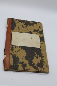
Cash Book, Report Book / Vegetable pathologist / Agricultural Department, Orchardist's cash book/ledger - Charles Wedge, Ringwood, 1928
Used by Charles Wedge for cash accounts, work on orchard, guest lists and ledgerLeather bound cash book/ledger from 1st July 1928 to 1954. Owned by Charles Wedge, orchardist of Ringwood. Red spine / dark charcoal / green covers. Gold printing on spine (see makers details). +Additional Keywords: Wedge, Charles E.L.Cash Book p 34; Ledger page 250; from 1st July 1928 -
 Greensborough Historical Society
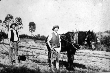
Photograph - Digital Image, Partington brothers ploughing, 1895c
Tom and Joe Partington working the horse and plough in the orchard fields at Willis Vale.A pioneer Greensborough family.Digital copy of black and white photograph.tom partington, joe partington, partington family, willis vale -
 Stanley Athenaeum & Public Room
Cash Book, North Eastern District Fruit Growers Association
Local families, orchards, expenditure includes rent paid by Stanley Athenaeum CommitteeCardboard ledger covered in a black moire pattern with red leather spine. Type written red label attached to front cover stating purpose of information therein - titled 'North Eastern District Fruit Growers Association, Cash book. Inside title page handwritten description of contents including start date - from 17/9/42. Final entry 8/12/76.north eastern district fruit growers association, stanley, myrtleford -
 Bendigo Historical Society Inc.
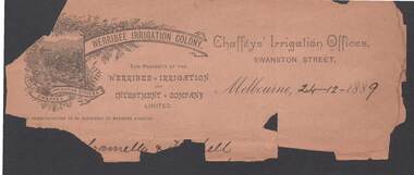
Document - CONNELLY, TATCHELL, DUNLOP COLLECTION: FRAGMENT OF INVOICE WERRIBBEE IRRIGATION COLONY
Invoice from Werribee Irrigation Colony, Chaffeys' Irrigation Offices, Swanston Street, Melbourne 24.12.1889. Bottom section is missing with details of transaction. Invoice has image of orchard, image surrounded by grapevines. Fragile condition.business, legal, chafffeys' irrigation offices, connelly, tatchell & dunlop, irrigation, mildura, werribee, industry -
 Whitehorse Historical Society Inc.
Postcard, Historic Postcard - Set 1 no 2 -Strathdon Homestead, 1931
Black and white historic postcard (Set 1 No 7) Strathdon Homestead, Springvale Road, Nunawading. Historic orchard 1931. Photo taken by Captain Charles Matheson. Original supplied by Marny Miller, his daughter.strathdon homestead, orchards, matheson, charles, miller, marny, nunawading library & information service -
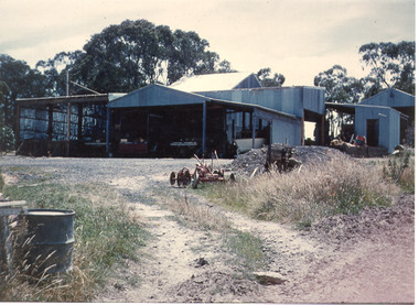 Southern Sherbrooke Historical Society Inc.Colour photograph of various vehicles in corrugated iron shedding at Narre Warren orchard. A barrel drum can be seen in the extreme left side of frame. The driveway heading to the sheds has a plough-like device resting.
 -
 Southern Sherbrooke Historical Society Inc.
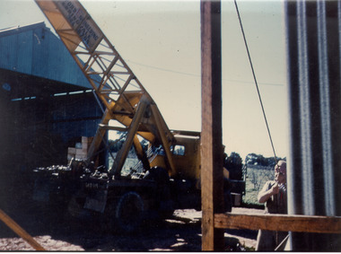
Photograph - Photo-colour- construction
Colour photograph of construction on a cool storage at Narre Warren North. Features a yellow crane, and a man at the bottom-right corner of the frame. Shedding can be seen on the left side of frame, and the orchard in the background. It appears to be winter. -
 University of Melbourne, Burnley Campus Archives
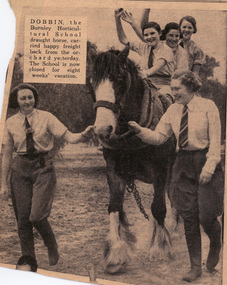
Newspaper - Newspaper Cutting, The Sun, Dobbin, 1937
Photograph in the "Sun'" December 18, 1937 p1. Caption, "Dobbin, the Burnley Horticultural School draught horse, carried happy freight back from the orchard yesterday. The school is now closed for 8 weeks' vacation."the sun, burnley horticultural college, dobbin, female students, draught horse, students working outside -
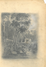 Bendigo Historical Society Inc.
Drawing - HARRIS COLLECTION: CHARCOAL SKETCH OF CREEK AND HUT
Charcoal sketch on cream background of creek, small hut on bank, eucalypts on LH side and in background. Most probably a depiction of the Harris orchard/vineyard on Axe Creek, Axedale, near the bridge on the Mt. Sugarloaf Road.George Harris, Axedaleartwork, harris vineyard -
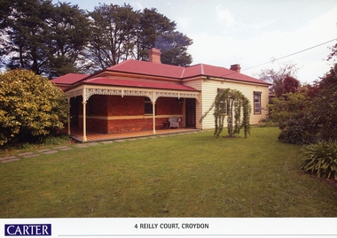 Ringwood and District Historical Society
Memorabilia, History of Kleinert's Homestead, 4 Reilly Court, Croydon, Victoria
Collection of maps and title deeds of Kleinert's 1886 homestead - 22 pages in pockets in black plastic spiral binder, compiled by Richard Carter, November 2008. Photocopies of title deeds and subdivisions. -
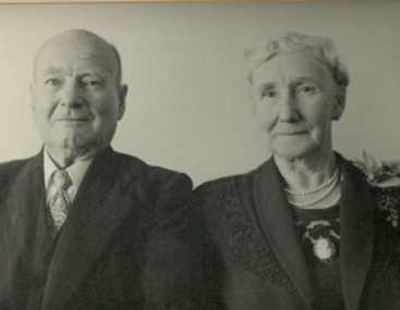 Federation University Historical Collection
Photograph - Photograph - Black and White, Albert and Grace Steane, c1942
Age of the couple, and Mrs Steane's orchard spray suggests it may be a Golden Wedding portrait.Black and white photograph of Albert W. Steane and his wife, Grace Steanealbert steane, albert w. steane, grace steane -
 St Kilda Historical Society
Ephemera - Ticket, Picnic to Park Orchards, 1936
Ticket to picnic at Park Orchards on 21 December 1936, organised by the St Kilda Unemployed Organisation with the support of the St Kilda City Council, Mayor (Cr Alfred Levy), Archie Michaelis MLA, and 'other well-known gentlemen'. The ticket appears to have been perforated to allow vouchers, printed on the back (for bus, dinner, toys, stockings, ice cream and tea) to be separated and used. Park Orchards is a residential suburb 23km north east of Melbourne that was created in 1925 on land used for orchards when timber merchants Australis Sharp and John Taylor launched the Park Orchards Country Club estate. Buyers were not attracted to the estate, and for many years all that existed were a clubhouse and various sporting facilities. It gained popularity when demand for housing surged in the 1950s.Grey/green coloured card, printed in blue on both sides and with 5 evenly spaced lines of perforations across the width.st kilda unemployed organisation, st kilda council -
 Whitehorse Historical Society Inc.
Photograph, Blanche Collier
Series of photographs loaned for copying by Robert Collier through Keith Rooney. Photographs have been scanned by Ted Arrowsmith at 300dpi as a 'tiff' and burnt onto a CD Rom. copies of photographs were produced from the CD Rom for inclusion in the album.Black and white photograph of Blanche Collier.springvale road tunstall, orchard, tunstall -
University of Melbourne, Burnley Campus Archives
Photograph, James Leslie Provan, Burnley 1942 Album Page 1, 1942
View from entrance towards Pavilion.entrance, pavilion, orchard -
University of Melbourne, Burnley Campus Archives
Document - Chart, Pollination
fruit trees, horticulture, orchard -
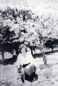
 Mount Evelyn History Group
Photo (framed) L Morrison, Seated portrait of Mrs Louisa Morrison nee Haag (?), c. 1940
This item was donated as a photograph of Louisa Morrison. Louisa (or Luisa) Rosanna Morrison nee Haag came from an early settler family in the farming community of Wandin. The woman photographed is in her old age. If this is indeed Louisa Morrison, the photograph would date from the early 1940s, since she died in 1946 at the age of 70. However the costume and the style of the photo suggest an earlier date, possibly the early 1900s. This could be Louisa's mother, Emma Martha Haynes, or mother-in-law Margaret (McNeil) Morrison. The woman is shown in a garden, probably because the family were farmers/orchardists. Louisa married Daniel McNeil Morrison, who was nine years her senior , in 1900. They had four children and farmed Morrisons' Orchard in Old Hereford Road, Mt Evelyn. The Morrison home was to become the important community house in Mt Evelyn, Morrison House. Morrison Reserve is part of their land, as was Yarra Hills Secondary College, Mt Evelyn Special Developmental School and the Reserve and Athletics facilities, including a tennis club. In 1981 the land title was changed to the Shire of Lillydale, who purchased the land and established the Morrison House Community House from 1976 (ie before they legally owned the land).This picture is of social significance as it is the only reputed picture of Louisa Morrison nee Haag.Brown round cornered frame with gold colour on inner frame. Painted plaster on frame chipped on top right. Coloured (painted) photograph of seated woman in upholstered chair with large brown cushion behind her. Garden setting. Black floor length dress, high necked, long sleeved. White cap on head. White cloth showing at neck.Bottom right hand corner, signature "F. RAPHAEL". Reverse: four inscriptions, one on each straight side, stamped in ink. Top: "MADE IN / AUSTRALIA". Right side: "THIS MOUNTING IS SPECIALLY DESIGNED AND / SELECTED WORKMANSHIP AND MATERIALS / GUARANTEED". Bottom: Table, 1 row, 2 columns. 1st cell: "STYLE / 1". 2ND CELL: "PRICE / 3 GNS". Left: box with 2 columns, 1 row. Left most column is divided horizontally into two, as is the 2nd column, but at a lower level. This creates four cells. Top left: "STYLE 1". Bottom left "PRICE 2 GNS". Top right: "TO BE SOLD AT PRICE MARKED OPPOSITE ONLY ON CONDITION THAT SAME IS MOUNTED ON ONE OF OUR SAMPLE STUDIES". Bottom left: "EMPIRE ART COMPANY LIMITED".louisa, morrison, haag, morrison house, farming, orchard, mt evelyn, photograph, wandin