Showing 178350 items
matching pitt-street
-
 Marysville & District Historical Society
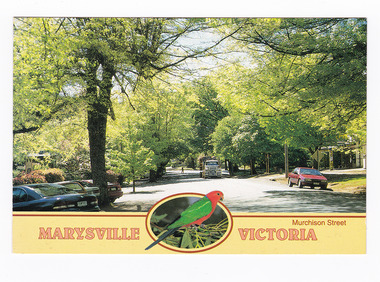
Postcard (Item) - Colour postcard, Neil Cutts, Marysville Victoria-Murchison Street, Unknown
A postcard in a series produced by the Rose Stereograph Company in Victoria, Australia as a souvenir of Marysville.A colour photograph of Murchison Street in Marysville, Victoria. Murchison Street is the main street of Marysville. The Rose Series postcard No. 3524.POST CARD The "Rose" Series/ De Luxe Proudly Printed in/ Australia Since 1880 AFFIX/ STAMP/ HERE/ Rose Series/ Post Card No./ 3524 ADDRESS/ POSTCODE Murchison Street/ MARYSVILLE, VICTORIA, AUSTRALIA/ Photo Neil Cutts Copyright Rose Stereograph Co., Glen Waverley, Victoria (03) 9560 7772marysville, victoria, murchison street, main street, postcard, souvenir, rose stereograph co, 3524 -
 Marysville & District Historical Society
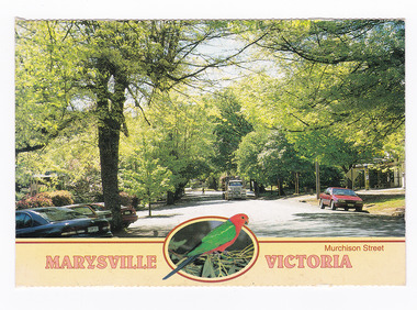
Postcard (item) - Colour postcard, Neil Cutts, Marysville Victoria-Murchison Street, Unknown
A postcard in a series produced by the Rose Stereograph Company in Victoria, Australia as a souvenir of Marysville.A colour photograph of Murchison Street in Marysville, Victoria. Murchison Street is the main street of Marysville. The Rose Series postcard No. 3524.POST CARD The "Rose" Series/ De Luxe Proudly Printed in/ Australia Since 1880 AFFIX/ STAMP/ HERE/ Rose Series/ Post Card No./ 3524 ADDRESS/ POSTCODE Murchison Street/ MARYSVILLE, VICTORIA, AUSTRALIA/ Photo Neil Cutts Copyright Rose Stereograph Co., Glen Waverley, Victoria (03) 9560 7772marysville, victoria, murchison street, main street, postcard, souvenir, rose stereograph co, 3524 -
 Marysville & District Historical Society
Postcard (item) - Colour postcard, Neil Cutts, Marysville Victoria-Murchison Street, Pre 2009
A postcard in a series produced by the Rose Stereograph Company in Victoria, Australia as a souvenir of Marysville.A colour photograph of Murchison Street in Marysville, Victoria. Murchison Street is the main street in Marysville. The Rose Series postcard No. 3524.POST CARD The "Rose" Series/ De Luxe Proudly Printed in/ Australia Since 1880 AFFIX/ STAMP/ HERE/ Rose Series/ Post Card No./ 3524 ADDRESS/ POSTCODE Murchison Street/ MARYSVILLE, VICTORIA, AUSTRALIA/ Photo Neil Cutts Copyright Rose Stereograph Co., Glen Waverley, Victoria (03) 9560 7772marysville, victoria, murchison street, main street, postcard, souvenir, rose stereograph co, 3524 -
 Federation University Historical Collection
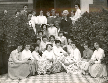
Photograph - Photograph - Black and white, Ballarat Teachers' College Resident's at 130 Victoria Street, Ballarat East, 1960s, 1960s
A number of female student teachers of the Ballarat Teachers' College pose at the front of their hostel at 130 Victoria Street, Ballarat East. Mavis Canty stand centre right in dark dress with a rose on the collar.Written on back "Ballarat Teachers' College, Mavis Canty with girls of the Ballarat Teachers College Hostel, 196-"ballarat teachers' college, 130 victoria street, hostel -
 Whitehorse Historical Society Inc.
Document, McDowall Street, Mitcham, 1/07/1999
Auction brochure for 4 bedroom brick veneer house, 24 McDowall Street, Mitcham, formerly Kennedy family home, 17 July 1999. Agent, Cody First National Real Estate.mcdowall street, mitcham, no. 24, kennedy, archibald francis -
 Linton and District Historical Society Inc
Photograph - Postcard, Post Office, Sussex Street, Linton
Black and white postcard photograph of the Linton Post Office in Sussex Street. Part of the Bank of New South Wales building can be seen on the left. The building is still standing but is now in private hands.post offices, buildings, linton -
 Melbourne Tram Museum
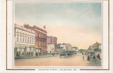
Artwork, other, Swanston Street Melbourne 1863
Colour print of a reproduction of an oil painting - Swanston Street from a point north of Little Bourke St looking south towards the Kings Domain. Reproduced by Kew Cottages and St Nicholas Parent's Association from a original print and lithographed by F Cogne, printed and published by Charles Troedel in his Melbourne Album 1863. Appears to have a number of horse drawn cabs parked in the centre of the street.Yields information about early Melbourne after the start of the gold rush.Reproduction of an oil painting - card - Swanston Street Melbourne 1863melbourne, horse drawn vehicles, swanston st -
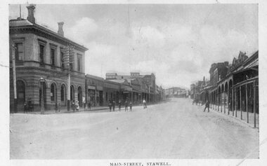
 Stawell Historical Society Inc
Photograph, 39 Main Street
39 Main Street: Mr Tom Healy did boot & shoe repairs from shop at front of house.Colour Photgraph. Brick home with brick fence. Small brick building opening onto footpathOn reverse: Shop where Tom Healy worked in Lower Main Streetbusiness, tom healy -
 Stawell Historical Society Inc
Photograph, Gold Reef Mall -- Main Street Stawell 2003
Gold Reef Mall Main Street 2003Colour Photograph: Looking East after the removal of the mall, from the Wimmera Street Intersection.stawell business -
 St Kilda Historical Society
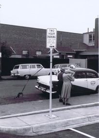
Photograph, Camden Street carpark, Balaclava, 11/1962
Opening of carpark Camden Street Balaclava black and white photograph, unmounted, original, good conditionOn back: Car Park opening Camden Street Nov 1962 From Leete Chemist -
 St Kilda Historical Society
Photograph, Camden Street carpark, Balaclava, 11/1962
Opening of carpark Camden Street Balaclava black and white photograph, unmounted, original, good conditionOn back: Car Park opening Camden Street Nov 1962 From Leete Chemist -
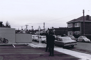
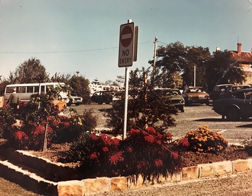 Stawell Historical Society Inc
Photograph, Car Park in Sloane Street looking towards Main Street Stawell c 1978 - Large coloured photograph
Colour photograph of Car Park Sloane Street looking towards Main Street Stawell. The car park was created when Main St. Stawell became a Pedestrian Mall c 1978Large coloured photograph taken from Sloane Street, looking towards Main St. The photo has a bus on the left hand side and cars in the car park. The photo is taken in front of a garden bed with a No Entry sign in the middle of the photograph.stawell -
 Ballarat Heritage Services
Photograph, Former Joseph Street Paton Memorial Presbyterian Church, Canadian, 2008, 26 /04/2008
The Jubilee of this church was held in 1933. "Paton Memorial Presbyterian Church. BALLARAT, Sunday Jubilee celebrations of the Paton Memorial Presbyterian Church were well attended in the week end. A basket picnic on Saturday at Eureka Stockade reserve was followed at night by a social gathering, at which a birthday cake was cut by Mrs. Amor, a foundation member. On Sunday special services were led by Rev. J. A. Moscript, assisted by the young men of St. John's Church. The church was originally founded, by the late Mrs. J. P. Murray to mission to the needs of the busy mining community which existed in Canadian in early years." (The Age, 06 November 1933.) PATON MEMORIAL CHURCH - An interesting tree-planting ceremony was performed in the grounds of the Paton Memorial Church on Saturday lost. Trees were put in by the scholars of the Sunday school to commemorate the enlistment of all the boys who had in any way been connected with the church. Sunday school, and Young Men's Club. The Mayor (Cr Levy) spoke in terms of praise of the lads who had enlisted to fight for right against might and the tyranny of Prussian militarism. The Hon. R. McGregor MLA., and the Revs. A. H. Moore and W. Rowlands were among those present. on also Mesdames J. P. Murray and McGowan, two of the founders of the church. During the afternoon Cr Levy planted a tree in honor of Mrs Murray. Afternoon tea was served by the ladies of the congregation. (The Age, 06 November 1933.) This church was in the middle of a Chinese neighbourhood, and the 1800s the leprosarium was in the vicinity. This bhurch was demolished not long after this photo was taken. Colour photograph of a weatherboard church in Joseph Street, Canadian. In 1937 this church was under the control of St. John's Peel-street, Ballarat. Members of the congregation: * Mrs. Amor - A foundation member. * Thomas Clarke and Isabella Clarke (formerly Ross) lived next door and according to family members "had a lot to do with the church". * Mrs McGowan - a founder of the church * Mrs. J. P. Murray founded the church to mission to the needs of the busy mining community which existed in Canadian in early years. joseph street ballarat, joseph street canadian, former joseph street paton memorial presbyterian church, ballarat, church, weatherboard church, presbyterian church, paton memorial church, clayton hill, claytons hill, leprosarium, chinese -
Marysville & District Historical Society
Document (Item) - Information document, Victorian Bushfire Reconstruction and Recovery Authority, Marysville - Murchison Street and Town Amenity Project, 2010
A document outlining the re-building and re-development of Murchison Street in Marysville in Victoria.A document outlining the re-building and re-development of Murchison Street in Marysville in Victoria.marysville, victoria, 2009 black saturday bushfires, murchison street -
Marysville & District Historical Society
Document (Item) - Research Document, Rene de Koning, Lyell Street Named After Charles Lyell (1797 - 1875), 13-08-2022
An account of the life of Charles Lyell whom Lyell Street in Marysville in Victoria is named for.An account of the life of Charles Lyell whom Lyell Street in Marysville in Victoria is named for. Charles Lyell was a Scottish geologist who demonstrated the power of known natural causes in explaining the earth's history.charles lyell, lyelll street, marysville, victoria -
Marysville & District Historical Society
Document (Item) - Research Document, Rene de Koning, Sedgwick Street Named After Adam Sedgwick (1785 - 1873), 13-08-2022
An account of the life of Adam Sedgwick whom Sedgwick Street in Marysville in Victoria is named for.An account of the life of Adam Sedgwick whom Sedgwick Street in Marysville in Victoria is named for. Adam Sedgwick was a British geologist and Anglican priest, one of the founders of modern geology. He proposed the Cambrian and Devonian period of the geological timescale. Based on work which he did on Welsh rock strata, he proposed the Cambrian period in 1835, in a joint publication in which Roderick Murchison also proposed the Silurian period. Later in 1840, to resolve what later became known as the Great Devonian Controversy about rocks near the boundary between the Silurian and Carboniferous periods, he and Murchison proposed the Devonian period. adam sedgwick, sedgwick street, marysville, victoria -
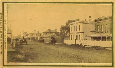 Bacchus Marsh & District Historical Society
Photograph, Main Street Bacchus Marsh 1883 looking east
View of Main Street Bacchus Marsh 1883, showing early notable buildings on the southern side of the street, including the Courthouse, National Bank of Australasia, Border Inn, Hall of Commerce building. Small sepia unframed photograph on card with gold border framing photograph. Housed in the album, 'Photographs of Bacchus Marsh and District in 1883 by Stevenson and McNicoll'. Several horse-drawn vehicles can be seen travelling along an unmade road. Piles of excavated dirt can be seen along the side of the road. Four substantial two-storeyed buildings can be seen along the southern side of the street.On the front: Stevenson & McNicoll. Photo. 108 Elizabeth St. Melbourne. COPIES CAN BE OBTAINED AT ANY TIME. On the back: LIGHT & TRUTH inscribed on a banner surmounted by a representation of the rising sun. Copies of this Portrait can be had at any time by sending the Name and Post Office Money Order or Stamps for the amount of order to STEVENSON & McNICOLL LATE BENSON & STEVENSON, Photographers. 108 Elizabeth Street, MELBOURNE. stevenson and mcnicoll 1883 photographs of bacchus marsh and district, bacchus marsh roads and streets, bacchus marsh main street 19th century -
 Eltham District Historical Society Inc
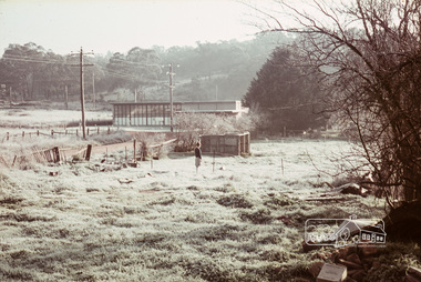
Photograph, Russell Yeoman, Frosty morning, 66 Susan Street, Eltham, c.1965, 1965c
Now the site of the Eltham Skate Park; Susan Street north of Bridge Street has since been renamed as an extension of Brisbane Street.Digital file only; created from original colour positive slide transparencyeltham, streets, susan street, eltham skate park, russell yeoman collection -
 Eltham District Historical Society Inc
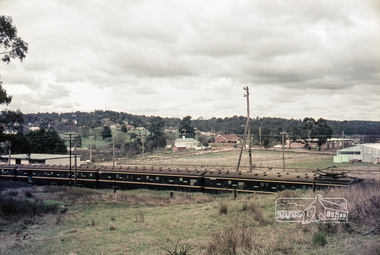
Photograph, Russell Yeoman, Looking south from Swan Street, Eltham, c,1965, 1965c
Train in foreground, Bridge street running parallel to train in background and Brisbane Street obscured by train. Susan Street north of Bridge Street (now Brisbane Street) on left. Vacant block of land is now the site of Bunnings. Presnt day SES building at corner of Susan and Bridge Street can be seen in centre background.The factory in lower left on Brisbane Street is the Sibbel Builders factory of Martin and Herman Sibbel who were ahead of their time with design and prefabricated frames and also built cabinetry in this factory.Digital file only; created from original colour positive slide transparencyeltham, streets, susan street, bridge street, brisbane street, train, bunnings, ses, state emergency service, sibbel builders, martin sibbel, herman sibbel -
 Surrey Hills Historical Society Collection
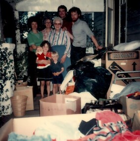
Photograph, 9 Vincent street, Surrey Hills
A colour photo of part of the interior of Mrs Mayer's house at 9 Vincent Street, Surrey Hills. It includes 3 women of varying ages, 2 men and 2 children, a boy and a girl. There are many boxes. at 9 Vincent st / Mrs Mayer's hospitality - / she was 80 y.o. / on her verandah / Pete[?] and Mike / & 2 chn there / for a fortnightwomen, children, men, verandah, boxes, toys, architectural features, personal effects -
 Kilmore Historical Society
Photograph, 5 Sydney Street, 2001
Connected with items: PHO-00010, PHO-00011 and PHO-00012.15cm x 10cm colour photograph of the cottage at the rear of Kilmore Communications, 5 Sydney Street. Printed on glossy photograph stock Konica brand. 2 photos included offering differing views of the property.Written on the back: Photo 1: Cottage at rear Former Kilmore Free Press Office 2001 5 Sydney St Photo: Heather Knight Photo 2: 5 Sydney St Cottage at rear shop - Kilmore Communications, former Kilmore Free Press Office. West side Sydney St, Kilmore, Opposite Husdon Park 2001 Photo: Heather Knight.real estate agents, cottages -
 Eltham District Historical Society Inc
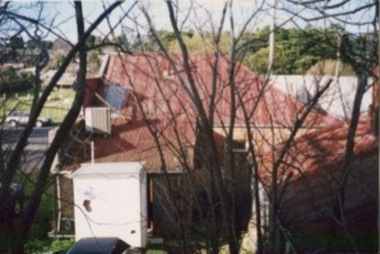
Photograph, Peter Bassett-Smith, Telephone Exchange, Main Road, Eltham, June 1977, 1977
Colour photograph of the telephone exchange viewed from opposite on Main Road looking up Pitt Street. (Has a permanent staff of 7)eltham, telephone exchange, buildings, main road -
 Stawell Historical Society Inc
Photograph, Main Street Stawell -- Postcard
Pre Motor Vehicle Street Scape. Gas Light and Telephone pole in front of Post Office.B/W. Main Street. Post.Office. up people - 1 man crossing road in front of card, woman is riding a bicycle up the steet. A group o fmen in front of Post Office another on the Street.Ajax Series POSTCARD Address Only -
Hume City Civic Collection
Print - Street Directory, Gregory"s Melbourne Street Directory, c1972
This street directory was published by Gregory's Guides & Maps Pty Ltd of 142 Clarence Street, Sydney NSW in c1972. It was used by the donor's family for many years to navigate their way around Melbourne and the metropolitan area. A street directory enclosed in a black leather detachable cover with gold embossing of a car on the front cover.Gold embossed vintage car on front of detachable cover.joan houston, streets, roads, maps, street directory -
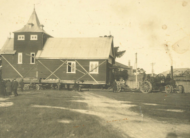 Ringwood and District Historical Society
Photograph, Moving Ringwood's Church of England Church from Pratt Street to Ringwood Street - 1924, 1924
Moving Church of England Church from Pratt Street to Ringwood StreetTyped below photograph, "Moving Church of England Church from Main St. Cnr. Pratt St. to Cnr. Ringwood St. and Civic Place - 1924" -
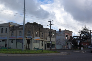 Ballarat Heritage Services
Photograph - Colour Photorgraph, Buildings on the Corner of Armstrong Street South and Eyre Street, Ballarat, 13/08/2020
Colour photograph on the corner of Armstrong Street South and Eyre Street, Ballaratballarat buildings, eyre street ballarat, armstrong street south -
Federation University Historical Collection
Plan, University of Ballarat Camp Street Precinct, 2000, c2000
The university aspect of the Camp Street Precinct was named the arts AcademyFramed plans of the Univesity of Ballarat (later Federation University) Camp Street Precinct. .1) Drawing of elevations for the university of Ballarat and the City of Ballarat Camp Street Precinct elevations including a new performing arts Building, Mining Exchange, Visual Arts Building, and Alfred Deakin Place. .2) Camp Street Precinct elevations including the Ballarat Post Office, State Offices and Old Courthouse. camp street, camp street precinct, plans, daryl jackson, arts academy -
 Orbost & District Historical Society
book, Stanley,Paul & Company, The Lady's Realm, November 1910 - April 1911
The Lady's Realm was a illustrated monthly women's magazine published in London in the 19th century, initially edited by W. H. Wilkins. It also published 36 volumes between 1896 and 1914. The Lady's Realm was a British women's magazine published from 1896 until 1914, possibly until 1915. It primarily targeted upper-class readers as well as an aspirational middle-class audience, featuring photographs, poems, fiction, and columns by popular authors such as Marie Corelli, Frances Hodgson Burnett, Jack London, and H.G. Wells. (Wikipedia) Founded in 1833, the Sydney Mechanics' School of Arts is the longest running School of Arts (also known as a "Mechanics' Institute") and the oldest continuous lending library in Australia. These magazines reflect women's interests in the early 20th century. Women’s magazines developed rapidly through the 1800s, reflecting both marketing developments and social changes. As the century progressed, publications aimed at women changed from the middle-class drawing-room journals of the 1830s and 1840s to the cheaper, chattier, more domestic magazines of the 1880s and 1890s. This item oi an example of a publication aimed at a particular social class.A thick hard back book with a dark blue and red fabric cover. It contains short stories by various authors. "SYDNEY MECHANICS SCHOOL OF ARTS 225 PITT STREET" on front cover.literature-lady's-realm short-stories -
 Glen Eira Historical Society
Album - Album page, "Ripponlea", Hotham Street, Circa 1972
This photograph is part of the Caulfield Historical Album 1972. This album was created in approximately 1972 as part of a project by the Caulfield Historical Society to assist in identifying buildings worthy of preservation. The album is related to a Survey the Caulfield Historical Society developed in collaboration with the National Trust of Australia (Victoria) and Caulfield City Council to identify historic buildings within the City of Caulfield that warranted the protection of a National Trust Classification. Principal photographer thought to be Trevor Hart, member of Caulfield Historical Society. Most photographs were taken between 1966-1972 with a small number of photographs being older and from unknown sources. All photographs are black and white except where stated, with 386 photographs over 198 pages.From Victorian Heritage Database citation for Rippon Lea H0614 https://vhd.heritagecouncil.vic.gov.au/places/427(as at 23/10/2020) Rippon Lea was commenced in 1868 by Frederick Sargood, a most successful politician and merchant. He was born in England in 1834 and arrived in Melbourne in 1850. He soon joined his father's wholesale soft goods firm, spending some time as its manager on the goldfields. Sargood entered the Legislative Council in 1874. He was Victoria?s first Minister for Defence in 1883. Sir Frederick Sargood was created CMG. In 1885 and KCMG in 1890 as a reward for his contribution to public life. He died suddenly in 1903. Rippon Lea was designed by the leading firm of architects, Reed and Barnes. Joseph Reed had travelled in Europe in 1863, including northern Italy. When he returned he introduced the use of polychromy. While not the first examples, Rippon Lea and the Independent Church in Collins Street were the best and set a fashion which became a distinctly Melbourne style, particularly used for houses and churches. Its popularity was possible because of the new availability of different coloured bricks. Reed's fine Lombardic Romanesque details soon became debased by others. As Sargood's family grew and his fortunes prospered, Rippon Lea was extended to include 33 rooms - a complete mansion. The cast iron porte cochere and the northern conservatory were added in 1897. The architects were Taylor and Fitts. The ballroom was added in 1882 and remodelled in 1889. Many alterations have changed the interior and exterior during the ownerships of Benjamin Nathan and later his daughter Mrs Louisa Jones in the 1930s and are in their own right of significance. Sir Thomas Bent owned the property from 1903 until 1911 but never lived there. He subdivided much of the land. The original garden dates from about 1868, and it seems that William Guilfoyle of the Botanic Gardens was involved. It was redesigned in a more natural style in the 1880s by Sargood and his head gardener, Adam Anderson. The lake, waterfalls, fernery, hill and grotto are balanced by mighty deciduous trees and conifers. These are interspersed with, but never dominated by Australian species such as eucalyptus and other exotics. The sinuous drive with its carefully prepared approach to the house is notable. The original vegetable gardens, orchard and outer paddocks no longer survive. The shade house is important as the largest known in Australia and possibly the world. Its curved plan and form of construction are particularly notable. It was built about 1884.Page 94 of Photograph Album with four photographs (three landscape and one portrait) of Ripponlea - stables, lookout and neighbouring cottages.Handwritten: "Ripponlea" Hotham Street [top right] / Neg 256 Dec 1972 STABLES [under top left photo] / Neg 248 Dec 1972 LOOKOUT [under top right photo] / Neg 254 Dec 1972 / COTTAGES WILLOW STREET [under bottom left photo] / Neg 259 Dec 1972 STABLES [under bottom right photo] / 94 [bottom right]trevor hart, elsternwick, mansion, hotham street, frederick sargood, reed and barnes, 1860's, 1890's, 1880's, benjamin nathan, nathan, louisa jones, thomas bent, sir thomas bent, william guilfoyle, guilfoyle, adam anderson, ripponlea, victorian, sir frederick sargood, architects, bricks, polychrome bricks, taylor and fitts, stables, lookouts, cottages, outbuildings, rippon lea -
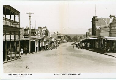 Stawell Historical Society Inc
Photograph, Main Street Stawell looking west towards the Post Office Rose series 1639
This photograph is of Main Street Stawell lookingwest around c 1930's. The photo was taken from the Bull and Mouth Hotel whis is on the left side and other business. On the road are a few people and cars.Black and white Postcard Rose Series 1639 Looking down Main St From the Bull and Mouth Hotel Partially visable on the left. The Rose series, P 1639 Main Street, Stawell, Victoriastawell business shops streetscape