Showing 2821 items
matching residence
-
 Mt Dandenong & District Historical Society Inc.
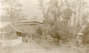
Photograph, Post Office Mt Dandenong North c1911, c1911
Landscape view. Mountjoy on hill, post office and residence with fence and sign post. Mrs Eliza Hand and (probably) Miss Florence hand outside. Another person standing on Ridge Road on the left. On right, the Methodist Church.eliza hand, florence hand, methodist church, mountjoy, mt dandenong north, post office, ridge road -
 Buninyong & District Historical Society
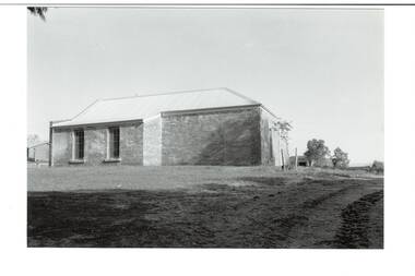
Photograph - B/W photograph, Clive Brooks, Warden's Office, Butter Factory, Cornish St. Buninyong, north side, 18 July 1993
1850's Gold Rush Police Precinct, later adapted for industrial use, and then used as Council Depot.B/W photo, north wall of Butter Factory (c1890), sandstone rear wall of Warden's Office (c1859) visisble to right. Cornish St. Buninyong near Yuille St. Old Police Station/Residence behind.buninyong, warden's office, butter factory, depot, couthouse, police -
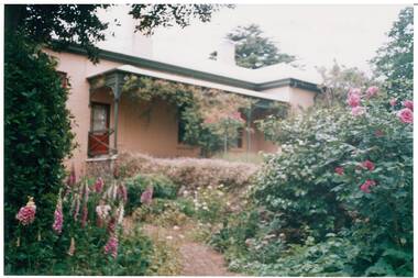
 Kew Historical Society Inc
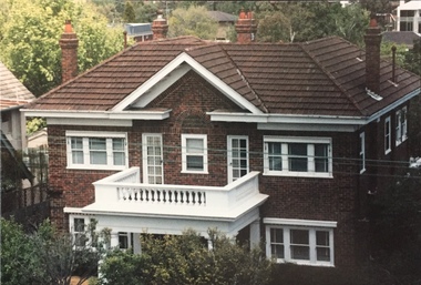
Photograph - 264 Cotham Road, 1988
The dwelling is representative of the development of the Georgian Revival style in the 1920s and 30s and its popularity amongst the upper-middle classes as a result of the work of William Hardy Wilson and Professor Leslie Wilkinson. It is of importance as a fine and largely intact designer/builder example of the Georgian Revival style, with American Georgian Revival influences. The dwelling embodies the principal characteristics of the style. American Georgian Revival influences are noted in the deep eaves with modillions, central broken pediment, brick quoins and presentation of the central porch. The garden wall, with arched opening, in the side setback appears to be an early or original landscape feature, based on the comparable brick work detail construction with that of the house. Considering this, it is the only early landscape feature extant which assists in providing some understanding of the original landscape layout of the property. (Criteria D and E) (Boroondara Planning Scheme)Colour photographic positive of 264 Cotham Road, Kew. The residence was constructed in 1931 for the Howitt family. 264 Cotham Road, Kew (HO813) is an individually listed building of significance under Amendment C294 of the Boroondara Planning Scheme. 264 cotham road -- kew (vic.) -
 Lakes Entrance Historical Society
Photograph - Kalimna, Fraser Nancy, 1980c
Colour photograph of private residences on the Kalimna escarpment. It shows houses above a timbered cliff at the northern shore of the North Arm of the lake, bare areas on cliff side indicating recent land slide. Lakes Entrance VictoriaHouses Seaview Parade Kalimna North Arm Lakes Entrance (on back) topography, waterways -
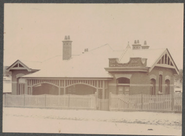
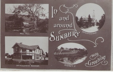 Sunbury Family History and Heritage Society Inc.
Post Card, c1912
A.J.Gregor, a Sunbury resident, had written the message on the back of the card to his cousin Harriet on the 11th April 1912 informing her of his state of health and some of the town's activities. Those mentioned were his need to travel to the hospital in Melbourne fot medical treatment, billiard contests at the local hotel, theatre shows in the town as well as weather details.The message on the reverse side of the card gives an insight into the day to day happenings in Sunbury in 1912.A non-digital sepia post card with four photographs of sites in Sunbury, namely the Mill Fall, Rupertswood mansion, Dr. Faulkner's residence and the race track at Kismet. A greeting is also on the card. A handwritten note is on the back of the card.IN/AND/AROUND/SUNBURY/WITH/GREETINGSgregor, a., sunbury town -
 Linton and District Historical Society Inc
Photograph, Bank of New South Wales, Sussex Street, Linton
Black and white image within a grey cardboard mount. Image is of a brick building with a picket fence. The building was originally the Bank of New South Wales building built between 1903-1904. The building in now a private residence.buildings, banking, bank of new south wales, linton -
 Lakes Entrance Historical Society
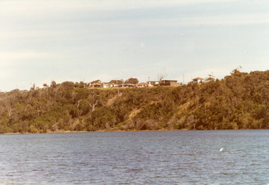
Photograph - Fraser Island, Holding M, 2000c
Colour photograph of Fraser Island, Gippsland Lakes, taken from Nyerimilang. It shows Flannagan Island mid centre, residence on Fraser Island, scrub covered dunes of southern shore of lake system. Lakes Entrance Victoria waterways, topography, islands -
 Lakes Entrance Historical Society
Photograph - Housing, 1999
Land became freehold, purchased by Jack Phillips.Colour photograph of a white painted brick residence with corrugated iron roof, sash windows, Set in bushland overlooking Lake Tyers, built on the site of the Mill Point saw mill at Mill Point Toorloo Arm Victoriahouses, heritage study -
 Buninyong & District Historical Society
Photograph - Original Colour Photo, Anne Beggs Sunter, "Brim Brim" Secret Garden, Nov. 1990
Well cared for sustantial goldrush residence with gardenColour photo Brim Brim cottage, built 1859, and cottage garden with brick pathbuninyong, brim brim, house, garden -
 Kilmore Historical Society
Photograph, 9 Sydney Street
Miss Isabelle Taylor live at this residence previously.15cm x 10cm colour photograph of the building which resides on the corner of Sydney Street and Bourke Street, Kilmore. Light beige rendered building, 9 Sydney Street Kilmore, with wooden detail around windows and doors. Neat garden in the front yard and matching colour picket fence. There is some renovation occurring in the photograph. Printed on matte photograph stock. -
 Lakes Entrance Historical Society
Photograph, H Cooper, The Lodge Nyerimilang, Kalimna West Victoria, 1910 c
The Lodge was the residence of the farm manager at Nyerimilang estateBlack and white photograph of The Lodge Nyerimilang showing back of building with old paling fence alongside, shed at right under large tree and lady with white calf and two little girls Kalimna West Victoriafarm -
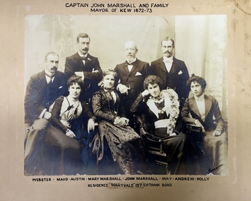 Kew Historical Society Inc
Photograph - Family Portrait, Captain John Marshall and Family, Mayor of Kew 1872-73, 1890s
Captain John Marshall was born in Dundee, Scotland c.1833. Within eleven years of his arrival in Melbourne in 1852, he had established an important colonial shipping company, Anderson & Marshall, and married Mary Austin, the eldest daughter of Thomas Austin Esq of Clifton Villa in Cotham Road. Elected to the Kew Borough Council in 1869, he remained an active member until 1875. During this period, he was elected Mayor of Kew in 1872. A Scottish Protestant by birth and conviction, John Marshall was, with David Beath, a member of the inaugural committee that began planning for a separate Presbyterian Church in Kew, lending the Committee the funds to purchase land on the corner of Cotham Road and Highbury Grove. John Marshall lived at his home, 'Maryfield', at what was then 239 [now 197] Cotham Road until shortly before his death at the age of 70 in January 1903. He was buried on 14 January in Grave 493, Presbyterian Compartment A, Boroondara General Cemetery.Family portrait of an important civic figure in Kew in the 19th century who was also a notable businessman and shipowner in the Colony of Victoria.Albumen Silver photograph on card of Captain John Marshall and family, Mayor of Kew 1872-73.The inscription was added by the family and at one stage modified. In addition to the title, the sitters' names are inscribed beneath the photograph on the mountCaptain John Marshall and family / Mayor of Kew 1872-73 Webster - Maud - Austin - Mary Marshall - John Marshall - May - Andrew - Polly / Residence “Maryvale” 197 Cotham Road. john marshall, maryvale (cotham road, kew), maryfield (cotham road, kew), webster marshall, maud marshall, austin marshall, mary marshall, may marshall, andrew marshall, polly marshall -
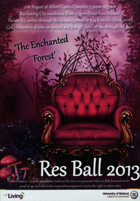 Federation University Historical Collection
Poster, The Enchanted Forest, 2013
poster advertising the University of Ballarat Residences Ball in 2013 colored poster printed "The Enchanted Forest...Res Ball...2013"poster, university of ballarat, res ball -
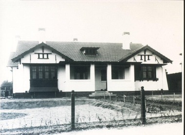 City of Ballarat Libraries
Photograph, 816 Lydiard Street North circa 1917
This residence was possibly built by Fred Duncan for John Dearden.house, housing, private residence, building, lydiard street north, ballarat, fred duncan, john dearden -
 Lakes Entrance Historical Society
Photograph - Bunga Haven, 1999
Built on site of Northrope's original bark residence (1890c).Colour photograph of a property known as Bunga Haven at 127 Lake Bunga Road. A timber dwelling with corrugated iron roof overlooking Lake Bunga and Bass Strait. Set in rustic garden and native bushland. Dropped log boundary fence and brush gate. Lakes Entrance Victoriaaccommodation, tourism -
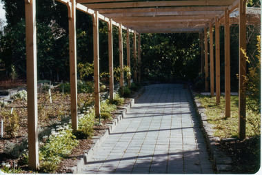 University of Melbourne, Burnley Campus Archives
Photograph - Colour print, Sunken Garden, c. 1983
Work commenced 1981 on the site of the former Principal's Residence Colour photographs. (1) Newly constructed pergola with new planting around Sunken Garden on the left. "Sunken Garden Pergola 1983-4." (2) A Gardener planting the Sunken Garden." (3)" Sunken Garden." pergola, planting, sunken garden -
 Ringwood and District Historical Society
Flyer, Auction Sale Advertisement - Ringwood Station Estate, Ringwood, Victoria - 1919
Folded double-sided brochure advertising auction of residential allotments on Saturday, 11 October, 1919, with town photographs including residence of Mr. and Mrs. Williams on the estate, location map, terms of sale, and summary of local features and services.Subdivision includes Bedford Road and Williams Grove (later Lena Grove). (Agents) Knight & Harwood, 315 Collins Street, Melbourne, Phones Central 10615, 10616, in conjunction with Godbehear & Co., Local Agents, Ringwood, Phone Ringwood 49. -
 Federation University Historical Collection
Photograph, Somerset Inn, Bannockburn
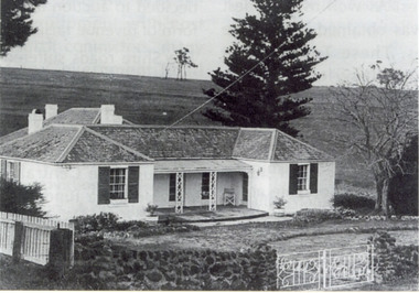
The Somerset Inn was built for Edward Carter Holmes by carpenter Isaac Sutherland and his two sons in 1855/1856. Situated on Bruce's Creek on the Shelford - Bannockburn Road. Bruce's Creek was the original name for current day Bannockburn. Black and white photograph of a house with slate roof and window shutters. The front fence is stone. The house is the former Somerset Inn (later a private residence). This building is located on the Leigh River at Bannockburn and was the home of Edward Carter and Sarah Holmes. Verso in blue ball point pen. "Somerset Inn on Leigh river Bannockburn. Home of Edward C. & Sarah Holmesholmes, leigh river, sarah holmes, ec holmes, holmes family collection, chatham-holmes family collection, edward carter holmes, farm, bannockburn -
 Bendigo Historical Society Inc.
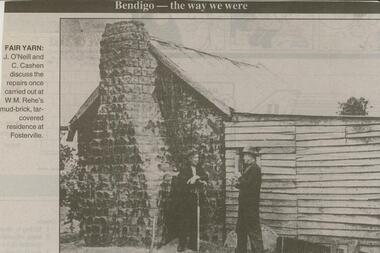
Newspaper - JENNY FOLEY COLLECTION: FARM YARN
Bendigo Advertiser ''The way we were'' from 2000. Fair yarn: J. O'Neill and C. Cashen discuss the repairs once carried out at W.M. Rehe's mud-brick, tar-covered residence at Fosterville. The clip is in a folder.newspaper, bendigo advertiser, the way we were -
 Bendigo Historical Society Inc.
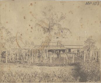
Photograph - HOMESTEAD, BENALLA, 1876, 1876
sepia photo: homestead, shingle roofed with couple standing in front. Garden and trellacing in foregound. On front MP 103/41 Mr. Jonathan Harris, Senr. And Mary his wife, his residence, Benalla, Victoria, Year 1876.buildings, residential, homestead -
 Bendigo Historical Society Inc.
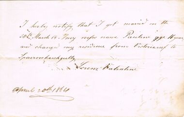
Document - ANCIENT ORDER OF FORESTERS NO. 3770 COLLECTION: CORRESPONDENCE
Note from Lorenz Valentine mentioning that got married on 30th March 64 and his wife's name was Pauline. He also changed his residence from Victoria reef to Sparrowhawk Gully. Dated April 20th 1864.societies, aof, correspondence, ancient order of foresters no. 3770 collection - correspondence, pauline valentine, lorenz valentine -
 Port Melbourne Historical & Preservation Society
Archive - Alan Mathews and family, 26 Oct 1938
The Mathews family have been in continuous ownership of 395 Howe Parade (was 8 Howe Parade until 1964 when addresses re-assigned), Port Melbourne from 1938 to the present (Sept 2019)Six folders of assorted documents relating to the life of Alan Mathews and his family. Documents relating to the purchase of residence on Howe Parade. State Savings bank of Victoria Insurance Policy for Howe parade property. Sum insured £850built environment - domestic, banking, alan mathews, j e mathews, state savings bank of victoria -
Port Melbourne Historical & Preservation Society
Archive - Alan Mathews and family, 9 Jul 1965
The Mathews family have been in continuous ownership of 395 Howe Parade (was 8 Howe Parade until 1964 when addresses re-assigned), Port Melbourne from 1938 to the present (Sept 2019)Six folders of assorted documents relating to the life of Alan Mathews and his family. Documents relating to the purchase of residence on Howe Parade. Victoria certificate of title (destroyed) of 8 Howe parade. (Presumably due to street address change)built environment - domestic, banking, alan mathews, j e mathews, state savings bank of victoria -
Port Melbourne Historical & Preservation Society
Photograph - Bridge Street, Then and Now series, David Thompson, 1996
Taken 1996 by David Thompson for "Then and Now""Bridge St - Then and Now" series. Bridge street, taken from near the tram crossing, looking towards Bay Street. Shows Station Hotel building, which had been converted into a private residence. (no 587 from series)built environment - commercial, built environment - domestic, engineering - roads streets lanes and footpaths, david thompson, bridge street, station hotel -
Port Melbourne Historical & Preservation Society
Plan - Annotated and handcoloured by Peter Libbis to indicate his research into Libbis family residences and hotels on copy of a section of an MMBW map, Melbourne and Metropolitan Board of Works, c. 1980s
Peter LIBBIS obtained these copies from the MMBW when he researched his family history in the 1980s. He has annotated them, colour in hotels etc. Donated to Society in 1997.One of a group of 19 photocopies of various 20th century MMBW plans, annotated/coloured in to indicate residences of Libbis family and local hotels, by Peter LIBBIS in family and hotel research - Railway yards/Swallow Street c 1950sbusiness and traders - hotels, built environment - domestic, transport - railways, melbourne and metropolitan board of works, libbis family -
Port Melbourne Historical & Preservation Society
Plan - Annotated and handcoloured by Peter LIBBIS to indicate his research into Libbis family residences and hotels on copy of a section of an MMBW map, Melbourne and Metropolitan Board of Works, c. 1980s
Peter LIBBIS obtained these copies from the MMBW when he researched his family history in the 1980s. He has annotated them, colour in hotels etc. Donated to Society in 1997.One of a group of 19 photocopies of various 20th century MMBW plans, annotated/coloured in to indicate residences of Libbis family and local hotels, by Peter LIBBIS in family and hotel research - Graham to Poolman, first bank houses 5.1.1930melbourne and metropolitan board of works, libbis family, business and traders - hotels, built environment - domestic, transport - railways -
Port Melbourne Historical & Preservation Society
Plan - Annotated and handcoloured by Peter Libbis to indicate his research into Libbis family residences and hotels on copy of a section of an MMBW map, Melbourne and Metropolitan Board of Works, c. 1980s
Peter LIBBIS obtained these copies from the MMBW when he researched his family history in the 1980s. He has annotated them, colour in hotels etc. Donated to Society in 1997.One of a group of 19 photocopies of various 20th century MMBW plans, annotated/coloured in to indicate residences of Libbis family and local hotels, by Peter LIBBIS in family and hotel research - Ross to Clark, Graham to Bridge, date unknownbusiness and traders - hotels, built environment - domestic, transport - railways, melbourne and metropolitan board of works, libbis family, caroline libbis, thomas libbis -
Port Melbourne Historical & Preservation Society
Plan - Annotated and handcoloured by Peter Libbis to indicate his research into Libbis family residences and hotels on copy of a section of an MMBW map, Melbourne and Metropolitan Board of Works, c. 1980s
Peter LIBBIS obtained these copies from the MMBW when he researched his family history in the 1980s. He has annotated them, colour in hotels etc. Donated to Society in 1997.One of a group of 19 photocopies of various 20th century MMBW plans, annotated/coloured in to indicate residences of Libbis family and local hotels, by Peter LIBBIS in family and hotel research - Nott to Dow, Graham to Bridge, post 1938business and traders - hotels, built environment - domestic, transport - railways, melbourne and metropolitan board of works, libbis family -
Port Melbourne Historical & Preservation Society
Plan - Annotated and handcoloured by Peter Libbis to indicate his research into Libbis family residences and hotels on copy of a section of an MMBW map, Melbourne and Metropolitan Board of Works, c. 1980s
Peter LIBBIS obtained these copies from the MMBW when he researched his family history in the 1980s. He has annotated them, colour in hotels etc. Donated to Society in 1997.One of a group of 19 photocopies of various 20th century MMBW plans, annotated/coloured in to indicate residences of Libbis family and local hotels, by Peter LIBBIS in family and hotel research - Pickles Street, Bridge to Liardet - date unknownbusiness and traders - hotels, built environment - domestic, transport - railways, melbourne and metropolitan board of works, libbis family -
Port Melbourne Historical & Preservation Society
Plan - Annotated and handcoloured by Peter Libbis to indicate his research into Libbis family residences and hotels on copy of a section of an MMBW map, Melbourne and Metropolitan Board of Works, c. 1980s
Peter LIBBIS obtained these copies from the MMBW when he researched his family history in the 1980s. He has annotated them, colour in hotels etc. Donated to Society in 1997.One of a group of 19 photocopies of various 20th century MMBW plans, annotated/coloured in to indicate residences of Libbis family and local hotels, by Peter LIBBIS in family and hotel research - Cruikshank/Pickles area (South Melbourne mostly)business and traders - hotels, built environment - domestic, transport - railways, melbourne and metropolitan board of works, libbis family