Showing 30430 items
matching will hills
-
 Bendigo Historical Society Inc.
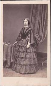
Photograph - PORTRAIT OF A LADY
Small portrait of a lady standing beside a table with a large cloth on it. Her right hand is resting on the table. She is wearing a long, high neck dress with a lace collar and darker pieces added to the bodice. The skirt has five layers.The Parisian Photographic Company. 45 Ludgate Hill London. E.C.photograph, portrait, female, portrait of a lady, photo -
 Coal Creek Community Park & Museum
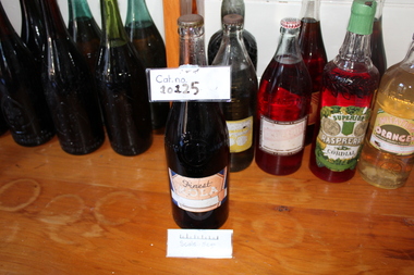
Finest Kola
Metal Cap Lid Faded LabelFinest Kola Bros COHN BENOIGO SWAN HILL C.B -
 Williamstown High School
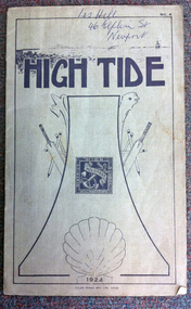
High Tide No. 4, Atlas Press Pty Ltd, High Tide 1924, 1924
School year book for the 1924 academic year. Contains sports results, scholarships awarded and student work.A booklet, comprising 16 p. Some black and white photographs and illustrations included. Cover of olive card printed in dark olive green.On cover in pen: Les Hill, 46 Elphin St Newport.williamstown high school, yearbooks, high tide -
 Williamstown High School
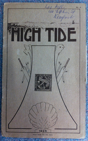
High Tide No.5, Atlas Press Pty Ltd, High Tide 1925
The school year book for the 1925 school year. It includes academic achievements for the year, sports results, prefects and student workA booklet comprising 16 p. Some black and white photographs and illustrations are included. The cover is of light brown card, printed in dark brown ink.On cover in pen: Les Hill, 46 Elphin St, Newport.williamstown high school, yearbooks, high tide -
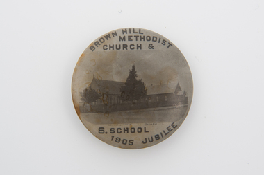 Uniting Church Archives - Synod of Victoria
Lapel Badge
Round badge. Brown with brown text and image."Brown Hill Methodist Church & S. School. 1905 Jubilee"brown hill methodist church, methodist church -
 Whitehorse Historical Society Inc.
Article, Our forbears grew tobacco in Nunawading
Article in 'Eastern Times' - Local historical writer Jean Uhl relates that there was a toll gate called 'Ballyshanassy' and that the Nunawading Road Board once had a court case versus Cotter about this gate.Article in 'Eastern Times' - Local historical writer Jean Uhl relates that there was a toll gate called 'Ballyshanassy' and that the Nunawading Road Board once had a court case versus Cotter about this gate. Another discovery was that Nunawading had a tobacco plantation, family members of John Jacob Meyer who married a Miss Schwartz and settled in Hawthorn in 1852 used to work on this plantation.Article in 'Eastern Times' - Local historical writer Jean Uhl relates that there was a toll gate called 'Ballyshanassy' and that the Nunawading Road Board once had a court case versus Cotter about this gate.agriculture, toll gates, uhl, jean, nunawading road board, meyer, john jacob, schwartz (miss), tobacco farming -
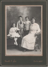 Rutherglen Historical Society
Image, Harold F. Sykes, c1910
Donated by Mrs Gail CarracherBlack & white unframed photograph, mounted on cardboard, of a group of four, one woman and three children. Subjects unknown. On mount below photo: "Harold F. Sykes - Broken Hill"children, families -
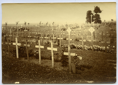 Magnet Galleries Melbourne Inc
British Cemetery, Flesquieres Hill, alban pearce-11.tif
on reverse: Flesquieres Hill , British Cemetery, Looking towards Cambraibritish, cemetery, ww1, world war 1, war, flesquieres hill -
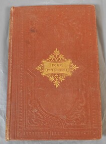 Bendigo Historical Society Inc.
Book - Aileen and John Ellison collection: Four Little People
BHS CollectionBrown hardcover children book. On the front in gold letters "Four Little People" in a cartouche with flowers around. On the spine the same words with other designs all in gold colour. The book has one hundred and twenty eight pages. Published by William P. Nimmo, Edinburgh, 1865. No author mentioned.Miss J. Arkle, Temperance Hill, January 25th, 1867children book, fantasy -
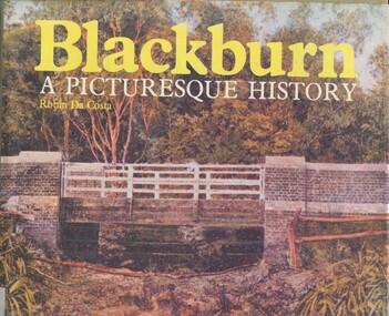 Surrey Hills Historical Society Collection
Book, Blackburn: A Picturesque History, 1978
This book focuses on the area's history and traces the development through settlement, adaptation and consolidation to the present. It discusses the history of early families, the railway, land boomers, churches and school. Robin da Costa, later Mrs Robin da Costa- Adams, came to live in Balwyn Road, Canterbury and joined the Canterbury History Group.Hardback book of 144 pages, indexed with multiple black and white photos.In Jocelyn Hall's writing: "Donated to Surrey Hills Neighbourhood Centre".(mr) james blackburn, meader's travellers' rest hotel, blackburn hotel, blackburn post office, blackburn railway station, blackburn pioneers, blackburn company, (mr) george augustus goodwin, (mr) thomas r b morton, blackburn brick works, st john's anglican church, blackburn methodist church, blackburn church of christ, blackburn presbyterian church, st thomas the apostle peace memorial church, seagoe common school, the courier blackburn, blackburn library, blackburn primary school, blackburn open-air school, blackburn creek hotel, blackburn college, blackburn kindergarten, newark grammar, blackburn hall, morton park, blackburn lake sanctuary, backhouse's dairy, blackburn lake, wandinong sanctuary, barelli bakehouse, blackburn cool store, blue moon fruit co-operative ltd, 1st blackburn scouts troop, blackburn and district tree preservation society, hotels, (ms) robin da costa -
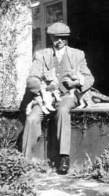 Linton and District Historical Society Inc
Photograph, Rex Bell
Black and white copy of photograph of Rex Bell wearing flat hat, pipe in mouth, nursing two cats, seated on verandah floor."Rex Bell sitting out the front of Emu Hill Homestead".rex bell, emu hill homestead, cats -
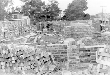 Surrey Hills Historical Society Collection
Photograph, Holy Trinity Church of England, Surrey Hills during construction, 1922, 1922
St George's Church of England, Mont Albert was built in 1886 and from 1904 until 1907 was known as Holy Trinity, Surrey Hills. As the population increased there was a need for a church in Surrey Hills. This brick church was consecrated in 1922 and replaced the earlier one built in 1907 on the adjacent site in Union Road. The house behind the church at 1 Montrose Street belonged to Mr W B Vine. There are 2 copies: the original donated print and an enlargement. The original is mounted on card with photo mounts along with 884, 885, 886 and 512. It measures 13 cm x 9 cm. Norman Carter took many photos of Surrey Hills and Mont Albert in the 1920s; many were associated with events and activities of the Church of England.Black and white photo of 3 men inspecting the construction site of the Holy Trinity Church of England in Union Road, Surrey Hills. The foundations are surrounded by piles of bricks. In the background is a small timber shed and beyond that a timber Edwardian home partly hidden by foliage.churches, holy trinity church, anglican church, building construction, montrose street, w b vine -
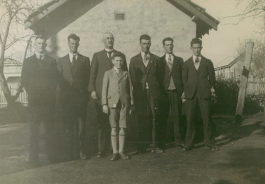 Brown Hill Progress Association Inc.
Photograph - Black and White, Comrie Family at Brown Hill
Angus Comrie was the Brown Hill PolicemanTwo photographs of the Comrie family at Brown Hill. .1) Angus Comrie and sons Murray, Jack, (Angus), Angus, Keith, Thomas, Roy (in front). The Methodist Sunday School Hall, Thompson Street is in the background. .2) Jack, Angus, Thomas, Keith, Murray, Roy in front. Seated: Angus (Snr) and Mary-ellen Comrie at 284 Humffray Street North. comrie, angus comrie, brown hill methodist sunday school hall, 284 humffray street, police, mary-ellen comrie -
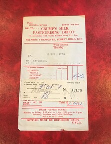 Surrey Hills Historical Society Collection
Document - Account and receipt, Receipt signed (?) ES - possibly Eric Scanlan, Crump's Milk Pasteurising Depot account with attached receipt, 2 October 1958 /6 October 1958
Crumps Dairy (Milk Pasteurising Depot) was located at 6 Benson Street, Surrey Hills on the corner of Weybridge Street until c1973. It was demolished after it had been badly vandalised. The business closed after cartons replaced glassperishables including milk, bread, meat and fruit and vegetables bottles for sale of milk. It was one of many small local facilities for processing and delivering milk that existed from the early 1920s. Eric William Walker Crump (1903-1981) headed the family business. Also involved were Kevin Eric Crump, Eric William Scanlan. NB/ Also held in this collection is a copy of a project by Chatham Primary School student, Susanne Pascoe, dated 1956 which includes photos of the dairy's operations. An oral history by Dave Croft, a driver for the dairy, who lived close by, is also relevant. The account also mentions 'Towt'. Canterbury Oliver Towt (1890-1962) was another dairyman whose premises was on the corner of Chatham and Mont Albert Roads.This is material evidence of business practice c1920s-1960s when accounts for goods received, especially perishables, were often hand-delivered on a weekly basis, with monies owed collected at the door. A paper account printed red on cream (discoloured) paper with the details of the date, account holder and address typed in and the amount owed hand-written in blue ink. The attached receipt has been stuck onto the account and filled out in grey pencil and blue ink. The amounts are in pounds, shillings and pence.Typed: 2/1; 2 OCT. 1958 M/- MATTHEWS, 42 GUILDFROD RD. SURREY HILLS, E.10dairies, crumps dairy, crumps milk pasteurising depot, kevin eric crump, eric william scanlan, eric william walker crump, towt's dairy, canterbury oliver towt, accounts, receipts, guildford road, geoff matthews, ruth matthews, benson street, towts rosehill dairy -
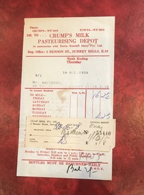 Surrey Hills Historical Society Collection
Document - Account and receipt, Receipt signed (?) ES - possibly Eric Scanlan, Crump's Milk Pasteurising Depot account with attached receipt, 16 October 1958 /20 October 1958
Crumps Dairy (Milk Pasteurising Depot) was located at 6 Benson Street, Surrey Hills on the corner of Weybridge Street until c1973. It was demolished after it had been badly vandalised. The business closed after cartons replaced glassperishables including milk, bread, meat and fruit and vegetables bottles for sale of milk. It was one of many small local facilities for processing and delivering milk that existed from the early 1920s. Eric William Walker Crump (1903-1981) headed the family business. Also involved were Kevin Eric Crump, Eric William Scanlan. NB/ Also held in this collection is a copy of a project by Chatham Primary School student, Susanne Pascoe, dated 1956 which includes photos of the dairy's operations. An oral history by Dave Croft, a driver for the dairy, who lived close by, is also relevant. The account also mentions 'Towt'. Canterbury Oliver Towt (1890-1962) was another dairyman whose premises was on the corner of Chatham and Mont Albert Roads.This is material evidence of business practice c1920s-1960s when accounts for goods received, especially perishables, were often hand-delivered on a weekly basis, with monies owed collected at the door. A paper account printed red on cream (discoloured) paper with the details of the date, account holder and address typed in and the amount owed hand-written in blue ink. The attached receipt has been stuck onto the account and filled out in grey pencil and blue ink. The amounts are in pounds, shillings and pence.Typed: 2/1; 16 OCT. 1958 M/- MATTHEWS, 42 GUILDFROD RD. SURREY HILLS, E.10dairies, crumps dairy, crumps milk pasteurising depot, kevin eric crump, eric william scanlan, eric william walker crump, towt's dairy, canterbury oliver towt, accounts, receipts, guildford road, geoff matthews, ruth matthews, benson street, towts rosehill dairy -
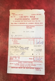 Surrey Hills Historical Society Collection
Document - Account and receipt, Receipt signed (?) ES - possibly Eric Scanlan, Crump's Milk Pasteurising Depot account with attached receipt, 18 September 1958 /22 September 1958
Crumps Dairy (Milk Pasteurising Depot) was located at 6 Benson Street, Surrey Hills on the corner of Weybridge Street until c1973. It was demolished after it had been badly vandalised. The business closed after cartons replaced glassperishables including milk, bread, meat and fruit and vegetables bottles for sale of milk. It was one of many small local facilities for processing and delivering milk that existed from the early 1920s. Eric William Walker Crump (1903-1981) headed the family business. Also involved were Kevin Eric Crump, Eric William Scanlan. NB/ Also held in this collection is a copy of a project by Chatham Primary School student, Susanne Pascoe, dated 1956 which includes photos of the dairy's operations. An oral history by Dave Croft, a driver for the dairy, who lived close by, is also relevant. The account also mentions 'Towt'. Canterbury Oliver Towt (1890-1962) was another dairyman whose premises was on the corner of Chatham and Mont Albert Roads.This is material evidence of business practice c1920s-1960s when accounts for goods received, especially perishables, were often hand-delivered on a weekly basis, with monies owed collected at the door. A paper account printed red on cream (discoloured) paper with the details of the date, account holder and address typed in and the amount owed hand-written in blue ink. The attached receipt has been stuck onto the account and filled out in grey pencil and blue ink. The amounts are in pounds, shillings and pence.Typed: 2/1; 18 SEPT. 1958 M/- MATTHEWS, 42 GUILDFROD RD. SURREY HILLS, E.10dairies, crumps dairy, crumps milk pasteurising depot, kevin eric crump, eric william scanlan, eric william walker crump, towt's dairy, canterbury oliver towt, accounts, receipts, guildford road, geoff matthews, ruth matthews, benson street, towts rosehill dairy -
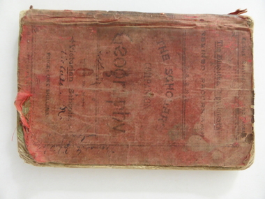 Warrnambool and District Historical Society Inc.
Book, Geography for State Schools, 1894
This book is a Yangery State School book owned by Tom Johnston in 1896. Yangery State School was established as a National School in 1858 with George McKay as the first head teacher. In 1909 the name was changed to Illowa and it was closed in 1970. We do not have many historical items that are associated with the old Yangery school. The Johnston family was associated with the Tower Hill/ Illowa area from the 1850s. " Sea View" was occupied by the McCullough family in the early 20th century.This book is retained because of its relationship with the Yangery State School and the Johnston family.This is a soft covered book of 118 pages. The cover is red cloth with black printing. The book contains printed material and some sketches and maps.It is dog eared, tattered and stained.It is much scribbled on the inside covers.Tom E Johnston Yangery State School No. 690 February 8th 96 T E Johnston Sea View Ilowa T.E Johnston Tower Hill tom johnston, yangery state school, tower hill, illowa -
 Eltham District Historical Society Inc
Photograph, George W. Bell, Detail, Cottage Entrance, Birch Cottage, Yarra Glen Road, Smiths Gully, Aug 1969, Aug 1969
EDHS Newsletter No. 182, September 2008 In the late 1970s when our Society was the Shire of Eltham Historical Society, an offer was made to the Society regarding use of an old cottage at Christmas Hills. For various reasons the offer ultimately lapsed The cottage sat beside Watsons Creek just outside the then Shire of Eltham but following municipal restructuring it now lies within the Shire of Nillumbik. At that time some research on the cottage was carried out for the Society by Keith Chappel as part of a larger research project that he was doing. Keith's notes were taken from Lands Department records and showed that house is the subject of a permissive occupancy of Crown land comprising the creek reserve. In 1903 a Miners Right of one acre in area was granted to Edwin Samuel Birch. In 1907 Birch applied to purchase this land but was unable to because it was part of the creek reserve. The documents show that the house existed at that time. Birch died in 1932 and his daughter Honor Mary Birch was granted a permit to occupy the residence. The future of the cottage remains precarious because of its location on Crown land. In 2007 the Andrew Ross Museum began a campaign to ensure that it is preserved. It included a video presentation on the history of the cottage under the title of "This Old House- Birch Cottage". Black and white photographDetail Cottage Entrance Williams Cottage Yarra Glen Rd Panton Hill Aug 1969 Photo - G.W.Bhouses, cottage, early settlers, yarra glen road, smiths gully, williams cottage, watsons creek, christmas hills, birch cottage, edwin samuel birch, honor mary birch -
 Eltham District Historical Society Inc
Photograph, George W. Bell, Detail, Front Wall, Birch Cottage, Yarra Glen Road, Smiths Gully, Aug 1969, Aug 1969
EDHS Newsletter No. 182, September 2008 In the late 1970s when our Society was the Shire of Eltham Historical Society, an offer was made to the Society regarding use of an old cottage at Christmas Hills. For various reasons the offer ultimately lapsed The cottage sat beside Watsons Creek just outside the then Shire of Eltham but following municipal restructuring it now lies within the Shire of Nillumbik. At that time some research on the cottage was carried out for the Society by Keith Chappel as part of a larger research project that he was doing. Keith's notes were taken from Lands Department records and showed that house is the subject of a permissive occupancy of Crown land comprising the creek reserve. In 1903 a Miners Right of one acre in area was granted to Edwin Samuel Birch. In 1907 Birch applied to purchase this land but was unable to because it was part of the creek reserve. The documents show that the house existed at that time. Birch died in 1932 and his daughter Honor Mary Birch was granted a permit to occupy the residence. The future of the cottage remains precarious because of its location on Crown land. In 2007 the Andrew Ross Museum began a campaign to ensure that it is preserved. It included a video presentation on the history of the cottage under the title of "This Old House- Birch Cottage". Black and white photographDetail of Front Wall Williams Cottage Yarra Glen Rd Panton Hill Aug 1969 Photo - G.W.Bhouses, cottage, early settlers, yarra glen road, smiths gully, williams cottage, watsons creek, christmas hills, birch cottage, edwin samuel birch, honor mary birch -
 Eltham District Historical Society Inc
Photograph, George W. Bell, Detail, Shed Wall, Birch Cottage, Yarra Glen Road, Smiths Gully, Aug 1969, Aug 1969
EDHS Newsletter No. 182, September 2008 In the late 1970s when our Society was the Shire of Eltham Historical Society, an offer was made to the Society regarding use of an old cottage at Christmas Hills. For various reasons the offer ultimately lapsed The cottage sat beside Watsons Creek just outside the then Shire of Eltham but following municipal restructuring it now lies within the Shire of Nillumbik. At that time some research on the cottage was carried out for the Society by Keith Chappel as part of a larger research project that he was doing. Keith's notes were taken from Lands Department records and showed that house is the subject of a permissive occupancy of Crown land comprising the creek reserve. In 1903 a Miners Right of one acre in area was granted to Edwin Samuel Birch. In 1907 Birch applied to purchase this land but was unable to because it was part of the creek reserve. The documents show that the house existed at that time. Birch died in 1932 and his daughter Honor Mary Birch was granted a permit to occupy the residence. The future of the cottage remains precarious because of its location on Crown land. In 2007 the Andrew Ross Museum began a campaign to ensure that it is preserved. It included a video presentation on the history of the cottage under the title of "This Old House- Birch Cottage". Black and white photographDetail of Shed Wall Williams Cottage Yarra Glen Rd Panton Hill Aug 1969 Photo - G.W.Bhouses, cottage, early settlers, yarra glen road, smiths gully, williams cottage, watsons creek, christmas hills, birch cottage, edwin samuel birch, honor mary birch -
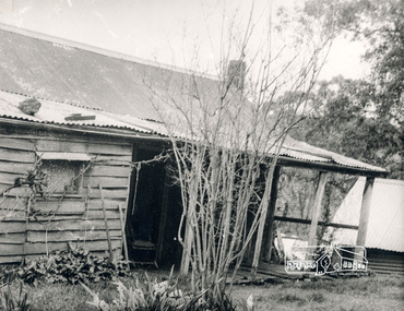
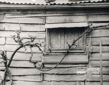
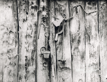
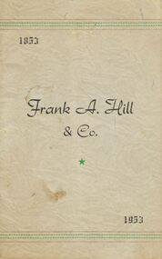 Bendigo Historical Society Inc.
Document - BOOKLET: FRANK A HILL & CO
12 page booklet re Frank A Hill (& Co.). Frank Hill (1853-1953). Reference also to Jack (John A) Hill and Frank K Hill (sons). Reference also to Dick O'Shea and Bill Malloy. Photographs of Hargreaves Street offices; Horse Bazaar, Charing Cross.Cambridge Press Bendigobendigo, business, frank a. hill & co, l. mcpherson sternberg & co, municipal cattle yards, bazaar at chaaring cross, mr frank a. hill, frank k. hill, john f. hill, honora margaret hill, bath lane, boort, pyramid, lockington, rochester, elmore, hargreaves street, mr tom doble, mr dick o'shea, mr bill malloy. -
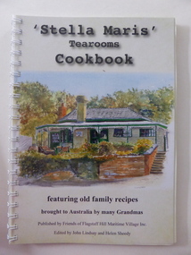 Warrnambool and District Historical Society Inc.
Book, Stella Maris tearooms FSH, 2016
This cook book has been published by the Friends of Flagstaff Hill Maritime Village Inc. This group do volunteer work at Flagstaff Hill, publicize the activities and historical collection at the Village and raise funds to carry out improvements and new installations. Flagstaff Hill Maritime Village was established in 1975, initially as a private venture sponsored by a group of businessmen in Warrnambool but it was later taken over by the Warrnambool City Council. It operates as an historical park and a tourist venture every day of the year except Christmas Day and has a night Sound and Light Show called ‘Shipwrecked’. The historical collection at the Village features many important shipwreck relics from the area, with the most important being the ‘Loch Ard’ ceramic peacock. The cook book is a tribute to the local women of the past and there are many recipes collected from the ‘Grannies’ of yesteryear. The tea rooms at Flagstaff Hill Maritime Village are called ‘Stella Maris’ (Latin for ‘Star of the Sea’) and call to mind both the maritime heritage of the area and the name of the Australian Catholic Missions to Seamen which still operates. This book is of interest as a product of Flagstaff Hill Maritime Village. It has been edited by John Lindsay who was one of the founders of Flagstaff Hill in 1975 and is today a Life Member and Helen Sheedy who has also been connected with the administration of the Village in the past. The book also features art works from many artists from Warrnambool and district. This is a soft cover book of 100 pages. The cover has a white background with a colour sketch of the Flagstaff Hill Maritime Village Stella Maris Tea Rooms on the front cover and a colour photograph of a Flagstaff Hill panorama on the back cover. The book contains an introduction, some information related to food, cooking and diet, recipes from the past and present, some local historical material and some information on the artists whose work is featured in the book. Many colour sketches and photographs are scattered throughout the text. The book is bound with plastic spiral rings and the front is covered with a sheet of clear plastic. stella maris tea rooms, warrnambool, flagstaff hill maritime village, history of warrnambool -
Surrey Hills Historical Society Collection
Archive - Vertical file, Aircraft
Roger Meyer was at one time a member of the Surrey Hills Historical Society. He presented at a meeting on a subject of personal interest. David (Dave) Staig lived in Surrey Hills and was an early aviator. A vertical file containing information related to aircraft and Surrey Hills; it is largely related to Dave Staig: 1. Article: ‘New air compass planned / invented here’, The Herald, about 1930s (1 page). 2. Article: ‘Homing pigeons, test on aeroplane flight’, Herald ? about 1933 (1 page). 3. Staig family – addresses July 1992 (1 page). 4. Timber cutting, extract from ‘David Staig a pioneer of Australian Aviation’ by W.L. Greer, 1991 (1 page). 5. David Staig notes from a conversation between Jocelyn Hall and Bill Greer, 1991 (1 page). 6. David Staig, aviator, notes from Bill Greer & Wes Vickers (undated) (1 page). 7. ‘Building a plane’ from ‘Slipstream’ as told to Chas. J. Gordon by Dave Staig (undated), (2 pages). 8. Surrey Hills Historical Society Inc. notice of meeting 20.9 (no year) (1 page). 9. Letter to Jocelyn Hall from David H. Staig c. Nov. 1993 or 4 (2 pages). 10. ‘The early aerodromes of Melbourne, and the origins of Essendon airport’, talk at Surrey Hills Historical Society by Roger Meyer, 19.4.2004 (12 pages including maps).roger meyer, dave staig, david staig -
 Bendigo Historical Society Inc.
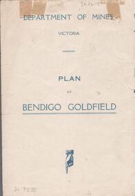
Map - BENDIGO GOLDFIELDS MAP
Map of the Bendigo Goldfield, showing reef lines, mines and significant geographical features such as Monument Hill, Quartz Hill and Diamond Hill. On the back of map 'Department of Mines, Victoria. Plan of Bendigo Goldfield.bendigo, mining, bendigo goldfields -
 Bendigo Historical Society Inc.
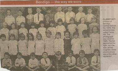
Newspaper - JENNY FOLEY COLLECTION: CLASSY ACT
Camp Hill Primary School, No.1976, was built on the site of the Police Camp in 1877 and incorporated a fire lookout tower.Bendigo Advertiser ''The way we were'' from Monday, August 5, 2002. Classy act: children of Bendigo Central School No. 1976. The school is now called Camp Hill. The photograph was taken in 1926. The lad second on the right , top row, was James Coghlan. The clip is in a folder.newspaper, bendigo advertiser, the way we were -
 Bendigo Historical Society Inc.
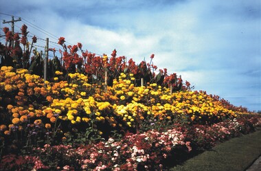
Slide - BENDIGO & EASTER FAIR, 1990
Bendigo Botanical Gardens, Napier St, White Hills. Commonly referred to as the White Hills Botanical Gardens. 1990.slide, bendigo, botanical gardens, bendigo botanical gardens, napier st., white hills, bendigo. commonly refered to as white hills botanical gardens. -
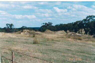 Buninyong & District Historical Society
Photograph - Original Photograph, Mullock heaps, Green Hill Diggings, Sandy's Hill Rd., Durham Lead (on private land), 20/03/1996
historic, miningColour photo, Mullock heaps, Green Hill Diggings, Sandy's Hill Rd., Durham Lead (on private land)mining, green hills, sandy's hill rd., durham lead -
 Whitehorse Historical Society Inc.
Document, Estate of James Keogh, 1897
Copy of the will of James KeoghCopy of the will of James Keogh, January 1897 involving land in Box Hill, Surrey Hills, Tunstall, Mitcham and Nunawading.Copy of the will of James Keoghkeogh, james, wills, thomas, ann, o'shannassey st, mitcham, mitcham road, albert street, haines street, springfield road, nunawading, springvale road, metropolitan avenue, watts street, box hill, victoria crescent, mont albert, whitehorse road, surrey hills, lightfoot street -
Whitehorse Historical Society Inc.
Book, When Box Hill was a village, 1991
When Box Hill was a village [reminisces of life in Box Hill in the 1940s and 1950s]When Box Hill was a village [reminisces of life in Box Hill in the 1940s and 1950s] by Rev. Dr. Gordon Moyes.When Box Hill was a village [reminisces of life in Box Hill in the 1940s and 1950s] box hill, moyes, gordon (rev dr) -
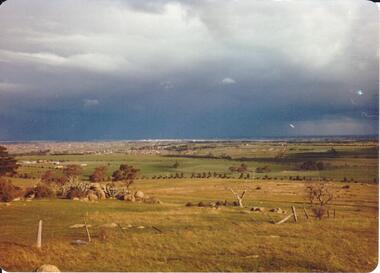 Hume City Civic Collection
Photograph, September 1994
Woodlands Park complex which includes 'Cumberland' and 'Dundonald' ruins and the Gellibrand Hill Quarries was acquired by the Victorian State Government in 1978 and is managed by Parks Victoria.A view taken from Gellibrand Hill looking east towards the expanding suburb of Broadmeadows. Apart from a few rocky outcrops and small trees the open grassland slopes away to a small line of conifers. Coloured photograph with rounded corners and matt finish.woodlands park, gellibrand hill, greene, william pomeroy, anne, george evans collection