Showing 19650 items matching " east "
-
 Kew Historical Society Inc
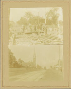
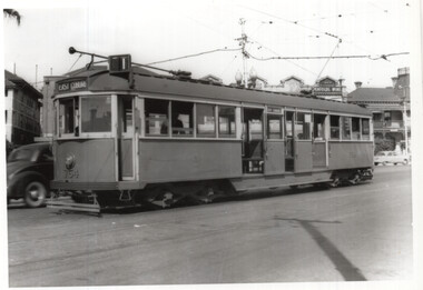
Photograph - Electric tram line construction in Cotham Road, Kew, E.J. Dower, 1913
One of a series of photographs, taken by Edgar James Dower in the second decade of the twentieth century. Born and raised in Olinda, his family later moved to Surrey Hills. He worked as an adult as a clerk in the city office of the Metropolitan Gas Company, and in his role as a 'collector', he was able to photograph scenes including the construction of tramlines and associated buildings in Kew, Hawthorn, Camberwell and Surrey Hills. Later he established a real estate agency with his brother - the E.J. Dower Real Estate Agency, Dandenong Office.The image is an historically significant record of the development of transport infrastructure which was used to connect Victorians in the first two decades of the twentieth century. This development resulted from increases in population and the consequent extension of Melbourne's suburbs. The photographs, both individually and collectively, richly detail the labour of workers and the tools and machinery used to create and extend Melbourne's tram network in the years preceding and during World War 1.Digital copy of two original mounted photographs depicting construction of a new electric tramline in Cotham Road, Kew. The upper photo shows workers standing among the newly laid tracks. The lower photo shows the vista of Cotham Road looking east towards the Kew Presbyterian Church on the corner of Highbury Road. Annotated verso: "Cotham Road Kew / Taken by E.J. Dower 1913"theme --- travelling by tram, theme -- connecting victorians by transport and communications, cotham road -- kew (vic.), trams -- kew (vic.) -
 Lakes Entrance Historical Society
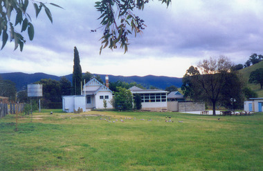
Photograph - Ensay Primary School, 1993
Taken July 1993.Colour photograph of the Ensay Primary School number 2953, East Gippsland. Taken from rear school ground, it shows original timber building with gable roof, brick chimney with chimney pot, portable classroom, playground and out buildings. Large corrugated iron tank on stand at side fence. Ensay Victoriaschools, buildings -
 Bacchus Marsh & District Historical Society
Map, Balliang Parish Map, County of Grant c.1907
A single page paper map showing parish plan map for Balliang. This parish area contains the localities of Balliang and Balliang East and is located south of the township of Bacchus Marsh. The map is pasted into a bound volume containing 76 maps or plans in total. High resolution digital image stored on BMDHS computer network. balliang victoria maps, balliang parish maps -
 National Vietnam Veterans Museum (NVVM)
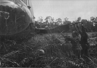
Photograph, Gibbons, Denis, Wounded VC Soldier
Denis Gibbons (1937 – 2011) Trained with the Australian Army, before travelling to Vietnam in January 1966, Denis stayed with the 1st Australian Task Force in Nui Dat working as a photographer. For almost five years Gibbons toured with nine Australian infantry battalions, posting compelling war images from within many combat zones before being flown out in late November 1970 after sustaining injuries. The images held within the National Vietnam Veterans Museum make up the Gibbons Collection. A black and white photograph of Diggers of 11 Platoon, D Company. 6 RAR/NZ (ANZAC) on Operation Lavarack, North East of the Australian Task Force Base at Nui Dat. The wounded VietCong is lifted aboard an American Dustoff helicopter by L/Cpl Grygierczyk. Pte J Korn and Maj J Lakeyphotograph, 11 platoon, d coy, 6 rar/nz, operation lavarack, nva/vc, dustoff, l/cpl grycierczyk, pte j korn, maj j lakey, gibbons collection catalogue, diggers, 6 rar/nz (anzac), viet cong, denis gibbons -
 National Vietnam Veterans Museum (NVVM)
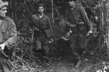
Photograph, Gibbons, Denis, Make Shift Stretcher
Denis Gibbons (1937 – 2011) Trained with the Australian Army, before travelling to Vietnam in January 1966, Denis stayed with the 1st Australian Task Force in Nui Dat working as a photographer. For almost five years Gibbons toured with nine Australian infantry battalions, posting compelling war images from within many combat zones before being flown out in late November 1970 after sustaining injuries. The images held within the National Vietnam Veterans Museum make up the Gibbons Collection. A black and white photograph of Diggers of 11 Platoon, D Company, 6 RAR/NZ (ANZAC) on Operation Lavarack, North East of the Australian Task Force base at Nui Dat, Pte J Korn and L/Cpl L Grygierczyk assist in carrying the makeshift stretcher a considerable distance to the helicopter landing zonephotograph, 11 platoon, d coy, 6 rar/nz, operation lavarack, australian task force, nui dat, pte j korn, l/cpl grycierczyk, gibbons collection catalogue, diggers, 6 rar/nz (anzac), dustoff helicopter, denis gibbons -
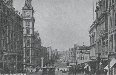 Melbourne Tram Museum
Postcard, "Bourke St Melbourne", 1900's
Postcard - silver finish known as "Collotype" - view of Bourke St looking east from near Elizabeth St. Has the GPO in the view. Photo c1900's. Card titled "Bourke St Melbourne". Postcard has a divided back with space for stamp, address and correspondence. In the top centre is a start with an "O" in the centre.trams, tramways, bourke st, cable trams, bourke st, elizabeth st -
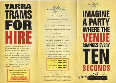 Melbourne Tram Museum
Pamphlet, Yarra Trams, "Imagine a party where the Venue changes every ten seconds", 2002
Pamphlet - 3 fold DL printed on gloss paper, titled "Imagine a party where the Venue changes every ten seconds", prompting the hire of trams for party's. Lists types of trams, conditions and what can be done. Gives contact details for Camberwell, Kew, East Preston and Southbank depots. Pamphlet c2002trams, tramways, yarra trams, charters, depots, passenger services -
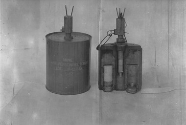 National Vietnam Veterans Museum (NVVM)
Photograph, Gibbons, Denis, M16A Anti-Personnel Mine
Denis Gibbons (1937 – 2011) Trained with the Australian Army, before travelling to Vietnam in January 1966, Denis stayed with the 1st Australian Task Force in Nui Dat working as a photographer. For almost five years Gibbons toured with nine Australian infantry battalions, posting compelling war images from within many combat zones before being flown out in late November 1970 after sustaining injuries. The images held within the National Vietnam Veterans Museum make up the Gibbons Collection. A black and white photograph of the M16A Anti-Personnel Mine used in the 'Barrier Minefield' from Dat Do to the sea, to prevent NVA/VietCong infiltration into the hills east of the 1 ATF base at Nui Dat. The mines were regularly stolen from the minefield and used against 1 ATF units (February 1967)photograph, 1 atf, nui dat, m16a anti personnel mine, barrier minefield, dat do, gibbons collection catalogue, nva/vc, nva/vietcong, denis gibbons -
 Bendigo Historical Society Inc.
Document - ALBERT RICHARDSON COLLECTION: VICTORIA HILL
Sixteen-page document with details about Victoria Hill, Victoria Spurs, East Victoria Reef, Try Me Well Reef and Hercules Reef. (ref: Dicker's Mining Record 23rd November 1861) Wittschiebe & Co's Claim Victoria Hill, Victoria Reef Gold Mining Company and Victoria Quartz are mentioned.bendigo, mining, victoria hill -
 Bayside Gallery - Bayside City Council Art & Heritage Collection
Map, H.B. Foot, Plan of the Brighton Estate containing 5120 acres, first special survey at Port Phillip, c. 1842
This plan records the Brighton Estate, also known as Dendy's Special Survey. In 1840 Henry Dendy, a farmer in Surrey, England acquired a "Special Survey" from the Commissioners for Land and Emigration which gave him the right to choose land in Port Phillip for the low price of £1 per acre for 5120 acres. Dendy appointed Jonathan Binns Were, as his agent, who later became a partner. Together, Dendy and Were decided on an area 5 miles south from Melbourne, bounded by North Road, East Boundary Road, South Road and to the west by Port Phillip Bay. Their Brighton Estate was first surveyed by T. S. Townsend in May 1841 and was re-surveyed by Robert Hoddle. Dendy and Were were making plans to sell the land and advertised a 30-guinea prize for the best subdivision which was to be divided into a village, marine residences, suburban and cultivation allotments, with the remainder being divided into country sections. The competition was won by H.B. Foot, who planned the village around a reserve and crescents and a 'green belt' forming the town boundary. brighton estate, dendy's special survey, special survey, henry dendy, jonathan binns were, w.b. were, survey, plan, map, brighton, george ward cole, baker's lithographer, hibernian, subdivision, town planning, cartographic material, h.b. foot -
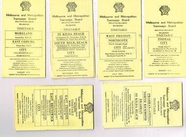 Melbourne Tram Museum
Ephemera - Timetable/s, Melbourne & Metropolitan Tramways Board (MMTB), "MMTB Tram Timetables", 1971 and 1973
Set of 20 MMTB Tram timetables, folded sheets, generally 10 sections, providing timetables for specific routes, day of week giving information on tram times at specific time points, route map, sections and fares and organisation address - 616 Little Collins St. Melbourne. All printed on yellow paper unless noted otherwise. .1 - Route 8 and 38, Toorak - City - August 1973 .2 - Route 9, 10 and 11, West Preston, Northcote - City - July 1973 .3 - Route - 1, 2, 4, 15, 16, 53, 55 - St Kilda Beach, south Melbourne Beach - City - September 1973 .4 - Route 1, 21, 15, 22 - Moreland, East Coburg - City - August 1973 .5 - Route 77, 78, 79 - Prahran - City, North Richmond, St Kilda Beach - October 1973 .6 - Route 88, 89, 90, 97 - East Preston, East Brunswick - City - October 1971 .7 - ditto - printed on green paper for Saturdays and Sundays. .8 - Route 59 - Essendon - City - June 1961 .9 - Route 8 - Toorak - City - Oct 1961, printed on yellow paper .10 - Routes 48, 40, 41, 37 and 74, 75, 76, 28 - North Balwyn or Burwood to City - March 1972 lists all the short routes by name and printed on yellow paper. .11 - Route 55, 56 and 68 - West Coburg - City or Domain Road - March 1972 - printed on yellow paper. .12 - Routes 48, 24, 40, 41, 29, 74, 75, 76 and 28 - North Balwyn or Burwood to City - March 1976 - printed on yellow paper. .13 - as for .12, Saturdays and Sundays - printed on green paper, ,14. - Route 19, 20 and 18 - Coburg - March 1972 - includes connecting bus to Upfield ,15 - Routes 1, 21, 15 and 22 - Moreland and East Coburg - March 1972 .16 - Routes 64, 65, 62 and 61 - East Brighton - June 1973 .17 - Route 3 - East Malvern - June 1973 ,18 - Route 5, 35 - June 1973 .19 - Route 82 - Footscray - Moonee Ponds - Oct. 1974 - bus Saturday afternoons and Sundays .20 - Route 67, 37 and 66 - Carnegie - June 1973trams, tramways, mmtb, timetables, melbourne, upfield, fares, route 1, route 2, route 3, route 4, route 5, route 8, route 9, route 10, route 11, route 15, route 16, route 18, route 19, route 20, route 21, route 22, route 38, route 35, route 37, route 53, route 55, route 66, route 67, route 77, route 78, route 79, route 88, route 89, route 90, route 96, route 97, route 59, route 48, route 40, route 41, route 37, route 74, route 75, route 76, route 82, route 28, route 55, route 56, route 68, route 29, route 24 -
 Eltham District Historical Society Inc
Negative - Photograph, J.A. McDonald, One Tree Hill Road Bridge, Christmas Hills, 2 July 1962
One Tree Hill Road Looking south 2/7/62 The bridge was destroyed by bushfires 15-16 January 1962. A temporary bridge was set up to the east sideRecord of various Shire of Eltham infrastructure works undertaken during the period of 1952-1962 involving bridge and road reconstruction projects, sometimes with Eltham Shire Council Project Reference numbers quoted. It was during this period that a number of significant improvements were made to roads and new bridges constructed within the shire that remain in place as of present day (2022). In many situations, the photos provide a tangible visible record of infrastructure that existed throughout the early days of the Shire. The album was put together by or under the direction of the Shire Engineer, J.A. McDonald.1962-07-02, bridge construction, christmas hills, infrastructure, shire of eltham, victorian bushfires - 1962, bush fires, one tree hill road, property damage -
 Eltham District Historical Society Inc
Slide, Shire of Eltham War Memorial Tower, Eltham-Yarra Glen Road, Kangaroo Ground, 24 Jul 1973
Looking east towards the tower across the western title of land purchased by Council 16 Feb. 1973 upon which the Moor-rul viewing platform and grasslands now stand.35 mm colour positive transparency Mount - Agfacolor Service (Blue)kangaroo ground, shire of eltham, war memorial tower, eltham-yarra glen road, shire of eltham war memorial -
 Eltham District Historical Society Inc
Slide, Shire of Eltham War Memorial Tower, Eltham-Yarra Glen Road, Kangaroo Ground, 24 Jul 1973
Looking east towards the tower across the western title of land purchased by Council 16 Feb. 1973 upon which the Moor-rul viewing platform and grasslands now stand.35 mm colour positive transparency Mount - Agfacolor Service (Blue)eltham-yarra glen road, kangaroo ground, shire of eltham war memorial, war memorial tower -
 Eltham District Historical Society Inc
Photograph, 22 York Street, Eltham (renumbered 28), c.1933
See EDHS 00096 22 York Street, Eltham, renumbered 28, former home of Bassett-Smith family. View north east from Bible Steet c.1933Roll of 35mm colour negative film, 7 stripsKodak GA 100 5095eltham, house, peter bassett smith, york street -
 Warrnambool and District Historical Society Inc.
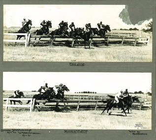
Photograph - Booval Steeplechase jumps 1921, C 1922
Booval Hill was an early name for the area to the north east of the Princes Highway and Liebig St intersection. The winning horse being a horse named Bloodstain which is recorded on the mount of the photograph. This item has a social and historical significance. Socially, it shows an early association which Warrnambool has had with steeple-chasing, with jumps racing still representing an important part of the horseracing calendar. The photo has a strong link with Warrnambool, being one of many photographs taken by The Jordan studios which operated out of premises in Liebig Street .Two black and white photos mounted on card showing the first and second last jumps of the Booval Steeplechase in 1921. There is text handwritten below the photographs and there is damage to the top right hand corner of the top photograph.Bottom photo signed Arthur Jordan 6 W'bool.steeplechase, warrnambool, booval, bloodstain, booval hill1921, jordan studios, horse racing -
 Tatura Irrigation & Wartime Camps Museum
Photographs, Hogan Street Tatura
1. Hogan Street looking west from railway crossing c.1900.|2. Hogan Street looking east from Ross Street, c.1900, Flanagan's Store.2 photos -
 Tatura Irrigation & Wartime Camps Museum
Photograph, Ken McInnes
Photo of Ken McInnes, former RAAF radar technician, and post war operated a wireless and TV repair service in shop, Hogan Street, north side, east of Ross Street. -
 Whitehorse Historical Society Inc.
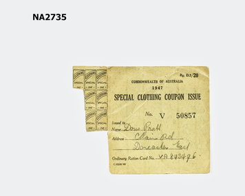
Domestic object - Coupon, c1947
Issued to Doris Pratt, Main Road, Doncaster East.|Ordinary Ration Card Number V A 843496|Special Clothing Coupon Issue No. V 50857|& coupons attached to card.Special clothing coupons issued by the Commonwealth of Australia in 1947. These were in addition to the ordinary ration coupons issued to people in general during and after the Second World War. They where issued for special purposes such as a serviceman on discharge or if people had lost clothing.Special Clothing Coupon Issue. Commonwealth of Australia 1947documents, cards -
Unions Ballarat
One Crowded Hour, Tim Bowden, 1987
A biography of Australian cameraman Neil Davis. Davis predominantly worked in South East Asia covering wars in the region. In 1985, he was shot and killed during a coup attempt in Bangkok.Insights into South East Asian regional conflicts with biographical detail.Paper; book. Front cover: black and white photograph of Neil Davis; black & red text.Front cover: title; author's name; short quote from review by the Weekend Australian.btlc, ballarat trades and labour council, ballarat trades hall, south east asia, davis, neil, war, coups, foreign correspondents, bowden, tim, interviews, biography -
Bialik College
Plan (item) - Bialik College development, 1980
Architectural plans for Bialik College, 429 Auburn Road, Hawthorn East, created by architects Joshua and Mary Pila, 1980. Please contact [email protected] to request access to this record.1980s -
 Stawell Historical Society Inc
Photograph, Pedestrian Mall & Lower Main Street Stawell from the Town Hall Clock Tower
Stawell Mall looking East from top of town hall in Main Street. Post Office Arcade in centre of photo. Stawell Technical School prominent in photo. 1980-1984stawell business streetscape -
![Hand-Drawn Map Centred on Chiltern by Frank Lebbell Frost [ca 1915-1918]](/media/collectors/51d110e42162ef12e06aa06b/items/51fb08452162ef156c79a623/item-media/52a11e6d2162ef1f0c9c0af4/item-fit-380x285.jpg) Beechworth Honey Archive
Beechworth Honey ArchiveHand-Drawn Map Centred on Chiltern by Frank Lebbell Frost [ca 1915-1918]
This is one of the maps drawn by Frank L. Frost while he was beekeeping in North-East Victoria. This particular map may be reference in the "Wooden" Diary on pages 12, 13 and 17.Front Side: Hand-drawn map centred on Chiltern showing the Melbourne road [Hume Freeway] and the Beechworth-Rutherglen road with detailed locations of flora in the region. Flora includes; Iron Bark, Stringy Bark, Red Box and Yellow Box. Details regarding quantity of flowers and quality of trees is included. Back Side: Some names and addresses are recorded in pencil. Drawn with black pen and grey lead on paper. A grid and other symbols are marked in red ink.hand drawn, hand-drawn, map, chiltern, 1915, beekeeper, frost, beechworth honey -
 National Wool Museum
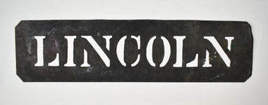
Stencil - LINCOLN
This stencil was used as a location stamp for the transportation of wool bales. Lincoln is a city in the English East Midlands. Wool bales marked LINCOLN would have been transported to England by sea.Wool bale export stencil - LINCOLNLINCOLNwool - transportation, wool sales, wool class, wool classers -
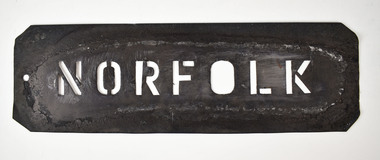 National Wool Museum
Stencil - NORFOLK
This stencil was used as a location stamp for the transportation of wool bales. Norfolk is a county in East Anglia in England. Wool bales marked NORFOLK would have been transported to England by sea.Wool bale export stencil - NORFOLKNORFOLKwool - transportation, wool sales, wool class, wool classers -
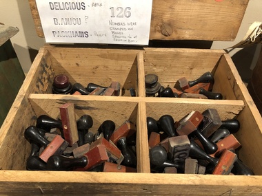 Mont De Lancey
Functional object - Rubber Stamps, 1940's
Used on Orchard of James Bienvenu's family from Doncaster East in the 1940's. Mr. Bienvenu is a descendant of Mr. A.H. Bienvenu, who came from Guernsey in the Channel Islands.Wooden box containing various fruit variety and number Rubber Stamps.stamps (tools), rubber stamps -
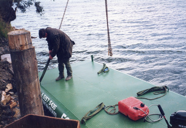 Lakes Entrance Historical Society
Photograph - Barges, Lakes Post Newspaper, 1999
Photo and article appeared in the Lakes Post Newspaper 28 July 1999|Barge was built by Wayne Smith for the firm East Gippsland Bridges.|Also two other photographs similarColour photograph of the launching of a new work barge in the Tambo River, Victoria.boats and boating, waterways, barges -
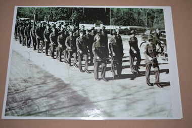 Wangaratta RSL Sub Branch
Photograph, C1940
Members of the 2/24th Battalion marching in Wangaratta. The Unit was raised in Wangaratta in July 1940 and the photograph was taken in late 1940 prior to overseas deployment to the middle east during WW2The 2/24th Battalion was an infantry battalion of the Australian Army, which served during World War II .A unit of all-volunteers, it was formed in July 1940 from primarily Victorian volunteers and was known as "Wangaratta's Own" because of the time the battalion spent in the town during its formative period prior to deployment overseas. It served in North Africa in 1941–1942 as part of the 26th Brigade, which was assigned to the 7th Division, before being reassigned to the 9th Division. In early 1943, the battalion returned to Australia and later took part in campaigns against the Japanese in New Guinea in 1943–1944 and Borneo in 1945, before being disbanded in 1946. The 2/24th suffered the highest number of casualties of any 2nd AIF infantry battalion. The Unit was granted the Freedom of the City by the Rural City of Wangaratta in 1990 and one of the first, if not the first, to receive this type of honour. Reproduced photograph of soldiers marching along street lined with parked vehiclesHandwritten on rear - 2/24th Marching in Wangaratta late 19402/24th battalion, wangaratta, ww2 -
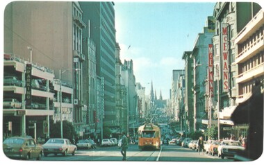 Melbourne Tram Museum
Postcard - Bourke St with PCC 1041, Carinya Postcards, mid 1970s
Carinya postcard looking east from Queen St with PCC class tram 1041 westbound to Spencer St. Has the McEwans building in the view along with a multistory car park.Yields information Bourke St and the use of PCC class tram 1041, the forerunner of the Z class tram.Postcard - by Carinya Postcards with rounded corners, address block, Number LV028trams, tramways, bourke street, pcc class, tram 1041, mcewans -
 Melbourne Tram Museum
Photograph - W5 754 at Beaconsfield Parade terminus, Keith Kings, 3/4/1953
Photograph shows W5 754 (East Coburg Route 1) at the former Beaconsfield Parade terminus at the intersection with Fitzroy St Kilda. The photographer notes the square windscreen windows on the tram.Yields information about tram 754 in 1953 in Beaconsfield Parade.Black and white photograph - W5 754 at Beaconsfield Parade terminus photo number G(y)(7)Has details and date written on the rear.tramways, beaconsfield parade, st kilda, fitzroy st, w5 class, tram 754, route 1