Showing 11453 items matching "maps "
-
 Port Melbourne Historical & Preservation Society
Flyer, Victorian Railways, Sandridge Rail Trail, 2005
Fold out flyer with black and white picture of train and three men on front cover. Back cover coloured image from Latrobe picture collection of park-like setting with steam train in background. Fold out section has history of railway, map, walk and ride descriptionstransport - railways, recreation, piers and wharves - station pier, piers and wharves - railway pier, hobson's bay railway company, melbourne and hobson's bay united railway company, montague street station, golden fleece hotel, st barnabas anglican church, north port station, lord raglan hotel -
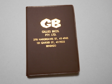 Bendigo Historical Society Inc.
Book - NORM GILLIES COLLECTION: COMPANY PROMOTIONAL POCKET DIARY
Gillies Company promotional gift pocket diary 1985 - blank unused Green plastic cover, with blue text including coloured maps Diary / almanac For 1985, covering 28/12/1984 to 02/01/1986 One of two pocket diaries (1984 diary refer 11850.17) -
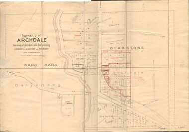 Bendigo Historical Society Inc.
Map - JACK FLYNN COLLECTION: TOWNSHIP OF ARCHDALE, /08/1904
Map: Township of Archdale, Parishes of Archdale and Dalyenong, Counties of Gladstone and Kara Kara. Scale 4 Chains to 1 Inch. Has attached letters relating to land transfers between the Estate of Kate Sanderson and Barry Frederick Mortlock also between Matilda Jane Sanderson and A. O. Proctor.J. K. Spark Narrister & Solicitor, Formerly Mitchell, Monotti & Sparkmap, gladstone, township, archdale, dalyenong, gladstone, kara kara -
National Vietnam Veterans Museum (NVVM)
Slide, Slides of 1960 era Army training in the field
Three boxes of slides. There were 4 donated but we have merged them into 3 boxes inside 1 larger box. There is also some microfiche sheets! The slides are Training courses produced by the Army Audio Vision covering such courses as First Aid, Map reading, chainsaw sharpening.australian army -
Tatura Irrigation & Wartime Camps Museum
Photograph, Goulburn Irrigation System, 1970s
Taken by photographer for State Rivers and Water Supply Commission.Medium sized black and white photograph. Map showing the Goulburn Irrigation System in Northern Victoria including Eildon Reservoir, Waranga Reservoir, Eppalock Reservoir, Eppalock, Cairn Curran, Laancoorie, Tullaroop Reservoirs, the Stuart Murray, Cattanach Canal, East Goulburn Main and Waranga Western Channels.goulburn weir, victorian state rivers and supply commission -
Whitehorse Historical Society Inc.
Document, Andreas Fritsch, 1992
History and maps of the brick quarry opened by Andreas Fritsch in Nunawading in 1856.History and maps of the brick quarry opened by Andreas Fritsch in Nunawading in 1856. His quarry was between Burwood Road and Mahoneys Reserve, enclosed with a letter from Geoff Ford, historian and pottery collector to Mrs B. Gray. Information on history taken from Niall Brennan's 'History of Nunawading'.History and maps of the brick quarry opened by Andreas Fritsch in Nunawading in 1856. clay, fritsch, andreas, ford, geoff, gray, beryl, pottery -
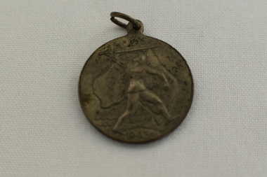 Dandenong/Cranbourne RSL Sub Branch
Medal - Victory Medal 1945
Circular Medal with suspension loop. The front of the medal shows a Knight with sword in front of an outline of Australia &1945, The back shows a map of the southern hemisphere showing Australia, Antarctica, New Zealand, South America & South Africa. At the top has words Victory Medal and the bottom manufacturers marking,Victory Medal 1945 -
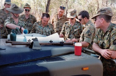 8th/13th Victorian Mounted Rifles Regimental Collection
Photograph
The Dibb Report into mainland defence of Australia,1986, among other things identified the requirement for protection of key assets in Northern Australia and the possibility of involving Army Reserve (Ares) units in this thus releasing regular forces for offensive operations. Dibb also pointed out that this defined role would result in a huge lift in Ares morale. In June 1988, the 3rd Division (3Div) conducted a Tactical Exercise without Troops (TEWT), Exercise ‘Distant Trumpet’ in the Katherine- Darwin area to study problems associated with defence against low level incursions against Tindal RAAF Base. Exercise ‘Northern Explorer’ followed in October of that year when units of the 3Div including A Squadron 8/13 Victorian Mounted Rifles sent patrol groups to get a first taste of environment and conditions. Post-Exercise reports had to include recommendations re: health, equipment and adaptation of Standing Operating Procedures (SOPs) in preparation for the new role deploying to Northern Australia. The first deployment by 8/13 Victorian Mounted Rifles was in 1988. Deployments continued in following years. In September 1993, 3 Troop (Wangaratta) VMR Squadron 4/19 PWLH commanded by Captain Kelvin Robertson deployed to NT. The training began with airfield defence at Tindal followed by a 1000km recon into Arnhem Land in four Landrovers. The troop reported on the conditions of the roads, airfields, bridges (mainly causeways) resources such as fuel supplies in the towns and infrastructure. Each troop taking different route. 3 Troop had the Northern route through Kakadu National park across the East Alligator River to Oenpelli then to Maningrida and Ramangining and south to the Central Arnhem Road and back to Tindal Air force Base. Colour photograph of group of soldiers of VMR Squadron 4/19Prince of Wales's Light Horse studying maps on bonnet of Land Rover during annual exercise in Northern Territory 1994.Major M. Annett wearing slouch hat, Sergeant Gary Wynn,without hat,,on his left. -
 Bendigo Historical Society Inc.
Document - MCCOLL, RANKIN AND STANISTREET COLLECTION: THANET LEASE, 1930's
Manilla folder of documents relating to the application by Herbert Jackson Leed for mining lease No. 10500, called the Thanet Lease. Containing a list of all of the owners of the allotments on the proposed lease and consent forms for them to sign. A map of the lease and of the subdivision of allotments 97 and 92. Various correspondence and application forms.gold, mining, land application, bendigo, gold mining. thanet lease, herbert jackson leed. -
 Ballarat Tramway Museum
Document - Re typed article, "Cable and rope traction", c1950
Three page typed copy of an article appeared in Engineering 1887 on Melbourne cable tramways construction. Carbon copy of typing on both sides of 1 sheet and 1 sheet of pink paper with hand drawn copy of a map in 4 colours. Image of document added 25/8/2013.trams, tramways, melbourne, cable trams, construction -
 Glen Eira City Council History and Heritage Collection
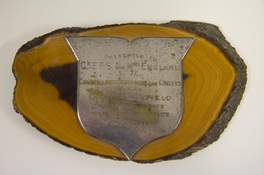
Plaque, commemorative, c. 1928
This Plaque was presented by the City of Caulfield to both Mr and Mrs E.F.S England, to commemorate their term of office as Mayor and Mayoress of the City. Councillor Egbert Frances Scott England was Mayor of the City of Caulfield in 1927.Silver shield attached by one screw to an irregular oval shaped segment of varnished Australian Mulga tree trunk. Label on the back of the tree trunk segment with a map of Australia and in the middle the words, "GENUINE AUSTRALIAN MULGA. S&D PRODUCT". Head of screw visible in the middle of the back of the plaque."PRESENTED TO to CR. E.F.S. AND MRS ENGLAND by the COUNCILLORS, RATEPAYERS AND CITIZENS of the CITY OF CAULFIELD TO COMMEMORATE THEIR TERM OF OFFICE IN THE YEAR 1928" -
 Wodonga & District Historical Society Inc
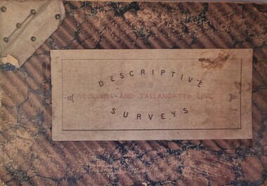
Booklet - Descriptive Surveys - Wodonga - Tallangatta Line
The first section of the Wodonga to Tallangatta line opened in 1889 and was further extended in 1891. It was a vital community link until the passenger service closed in September 1961. The last regular goods train on the line ran on 21st April 1978. These maps give detail of the surveying and building of the line.A collection of replicas of survey maps acquired to build the Wodonga to Tallangatta Railway line. Each survey includes a diagram of a portion of the line showing survey measurements and details of the land which that portion of the line will run through. It also includes the name of the landowner from whom the necessary land was acquired.The first section of the Wodonga to Tallangatta line opened in 1889 and was further extended in 1891. It was a vital community link until the passenger service closed in September 1961. The last regular goods train on the line ran on 21st April 1978. These maps give detail of the surveying and building of the line.victorian railways, wodonga to tallangatta rail service -
 Wodonga & District Historical Society Inc
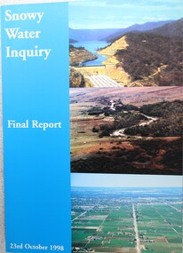
Book - Snowy Water Inquiry Final Report 23rd October 1998, Robert Webster et al, 1998
The Snowy Water Inquiry was commissioned in 1998 with a brief to recommend environmental water release options to the Commonwealth, Victorian, and NSW Governments so that corporatisation of the Snowy Mountains Scheme could proceed. This book contains the findings of the Inquiry into water allocation and uses of the Snowy River.A book of 160 pp - Snowy River Inquiry Final report 23rd October 1998. Submitted to the Governments of New South Wales and Victoria / Commissioner: The Hon. Robert Webster. On the front cover are three aerial photographs of the Snowy River and Snowy Hydro Scheme. The book contains maps and photographs.non-fictionThe Snowy Water Inquiry was commissioned in 1998 with a brief to recommend environmental water release options to the Commonwealth, Victorian, and NSW Governments so that corporatisation of the Snowy Mountains Scheme could proceed. This book contains the findings of the Inquiry into water allocation and uses of the Snowy River.snowy river hydro, snowy river government inquiry, water allocations, water resources developmen -
 Ringwood and District Historical Society
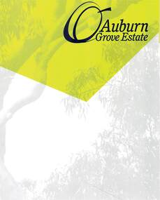
Document - Land Sale Folder, Auburn Grove Estate Ringwood East - 2011-2013
Folder containing flyers and multi-fold colour pamphlet advertising Auburn Grove Estate with maps and layout of subdivision and photographs of area. Flyers for First Release Auction 6 August, 2011 enclosed, and Second and Final Release Private Sale flyer with copy showing handwritten sale prices.Estate plan includes Auburn Grove off Longview Road and adjoining Tintern Grammar School, Ringwood East, Vic. Agents - Carter Real Estate, 90 Maroondah Highway, Ringwood Vic 3134. Phone 9870 6211 Fax 9870 6024. Accompanying folder includes handwritten auctioneer's notation (Richard Carter) on the name, that Auburn Grove Estate is adjacent to Tintern Farm - Tintern School originally having moved to Ringwood East from Auburn, Melbourne (1953). -
Port Melbourne Historical & Preservation Society
Photograph, Aerial Survey of Port Melbourne; December 1945, 2105
Seventeen (17) individual photos were joined together by John KIRBY to make a compsite image.Aerial Survey of Port Melbourne; December 1945 Large photograph mounted on foam board. Shows aerial view of Port Melbourne showing its extent from the Bay. Panel on right hand side has key to numbered areas on map . PMHPS logo on top left cornereclipse picture theatre, brookes lemos ltd, built environment, local government, natural environment, built environment - industrial, religion - roman catholic church (st josephs), gmh, general motors-holden, rotten row, sport - trotting, j kitchen & sons pty ltd, australian wool board, government aircraft factory, gaf, commonwealth aircraft corporation, cac, north port oval, fire and fire services, market reserve, religion - presbyterian church, leading lights, foresters arms hotel, commonwealth government engine works, st josephs catholic primary school, mission to seamen, centenary bridge, naval drill hall, mail exchange, gasworks, piers and wharves - town pier, robert harper & co ltd, ran - royal australian navy, hmas lonsdale, port melbourne yacht club, pmyc -
Bendigo Historical Society Inc.
Book - BENDIGO THE GOLDEN AGE RETRACED, 1973
BHS CollectionBendigo The Golden Age Retraced History of Bendigo 64 pages. Black and white illustrationd. Mallaya Publications. Printed by Brown Prior Anderson Melbourne. Mustard coloured soft cover. Illustration of tram and poppet head on the cover. Map od Bendigo printed inside front and back covers.Jan Neil -
 Bendigo Historical Society Inc.
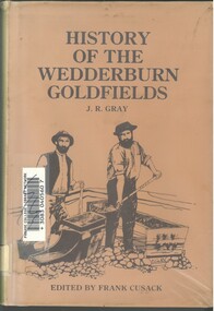
Book - HISTORY OF THE WEDDERBURN GOLDFIELDS, 1888
Gold was first discovered in 1852 on what was then named Korong or Mt Korong goldfields. It was soon found that the area was not suitable for alluvial mining because of a lack of water but quartz mining was more successful. The township of Wedderburn was surveyed 1856/57. The first public crushing works was established in 1859.Hardcover book with printed dust jacket and plastic cover. 92 pages with black and white illustrations, fold out map and index. Covers the history of the Wedderburn Goldfields and the discovery of gold generally in Australia from the 1850s until c1880s. Written by Joshua R Gray and edited by Frank Cusack.Joshua R Gray and Frank Cusack.gold, goldfields, goldfield -
 Melbourne Tram Museum
Drawing, Melbourne & Metropolitan Tramways Board (MMTB), "MMTB Electric Tramway System 1971", 1971
Map or drawing titled "MMTB Electric Tramway System 1971", giving a detailed layout of the Melbourne tram system in 1971. shows depot, storage depots, workshops and tramway terminus names and route numbers. Has a drawing number of P14359 See Reg Item 253 for a 1979 copy.trams, tramways, mmtb, melbourne, map, routes -
 Melbourne Tram Museum
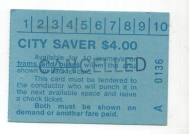
Ephemera - Ticket, Metropolitan Transit Authority (MTA), "City Saver", early 1980's
City Saver – A0136 - $4.00 printed on blue card with a map of the available CBD area on the back.. - has space for 10 punch marks. Gives details of availability. See Reg Item 963 for the check tickets and 1030 for another example of a $4 ticket. Has been stamped "CANCELLED"trams, tramways, mta, ticket, city section -
 Melbourne Tram Museum
Pamphlet, Yarra Trams, "White Night 2014", 2014
Pamphlets - 8 fold DL full colour printed on off white paper, titled "White Night 2014", detailing the event, public transport, map and what tram alterations, public transport guide, and times - for 22 and 23 Feb. 2014. Published by the PTV. Two copies held.trams, tramways, events, melbourne, white night, tram services -
 Melbourne Tram Museum
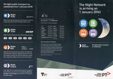
Pamphlet, Public Transport Victoria (PTV), "The night network is arriving on 1 January 2016", late 2015
Pamphlet - 3 fold DL titled "The night network is arriving on 1 January 2016", giving details of the night services on trains, trams, buses and coaches. Has a diagrammatic map of services. Provides contact details, language phone numbers. Published late 2015, Two copies held.trams, tramways, night trams, public transport, ptv, buses, railways, all night services -
 Melbourne Tram Museum
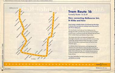
Newspaper, Progress Leader, "Tram Route 16", 11/10/2004 12:00:00 AM
Newspaper clipping titled "Tram Route 16", advert in the Progress Leader 11/10/2004 about the combining of routes 69 and 16 Melbourne University St Kilda and Kew from 17/10/2004. Has a Map of the route, Metlink contact details and Yarra Trams logo.trams, tramways, route 69, route 16, kew -
 Bendigo Military Museum
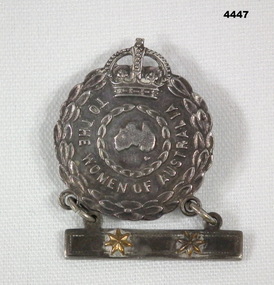
Badge - FEMALE RELATIVES BADGE, 1 BAR WW2, Amor Sydney, c1939- 1947
In WW2, this badge was issued to the nearest female relative, that has a service member abroad. Each star on the bar is for a serving member. Badge A293587, was issued to GREEN, C. Of 'Morneve'. Leopold street, Kangaroo point, Inverloch, VIC. Her relationship is noted as (S) sister of Denis and (E) of Annie. The two stars were for these Defence Force members:- V315242. BOURKE, Denis Patrick. Discharged 1 APR 1946 of the 39 WORKS Coy. VF389600. BOURKE, Annie Irene. Discharged 15 FEB 1946. Unit was Aust. Womens Army Service. A circular silver badge. Around the circumference are oak leaves. At the top is a Royal Crown. In the center of the badge is a map of Australia, which is surrounded by a leaf pattern. Between the two rings of leaves, are the words "to the Women of Australia". Suspended beneath the badge is a rectangular silver bar. On that bar are two gold stars.On the rear is stamped the number A293587.mothers badge, ww2 -
Glen Eira Historical Society
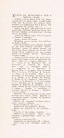
Article - Rosstown Railway
... Maps ...This file contains three items: 1/A review of the ROSSTOWN RAIL TRAIL from LIVING IN GLEN EIRA, vol. 11, 2004, Issue 4, no. 25, date and author unknown. The review explains the purpose of the Rail Trail with a brief narrative of the history behind Rosstown Sugar Mill Railway line. Concluding with information on the location of the Trail and the expected time required to walk the entire track included in the review is a map of the Rail Trail, which marks significant sites along the trail with historic pictures. 2/A newspaper article from THE AGE, dated Tuesday 21/10/1980 and written by Iola Matthews, reporting on the circumstances that led to the publication of the book RETURN TO ROSSTOWN written by Des Jowett and Ian Weickhardt. The article begins with a brief biography of the authors before moving into details of the book’s content, providing a further biography of W. Murray Ross which includes information on his financial ventures – particularly the Rosstown Rail – his marriage and children. The article includes a black and white photograph of Weickhardt and Jowett walking along the route of the railway line, an illustration of the Rosstown sugar works and a map of the area surrounding the site of the mill. 3/Three photocopies of a black and white illustration of the Rosstown sugar works from the east, undated and artist unknown.rosstown rail trail, rosstown, ross william, ross w. murray, ross murray, sugar beet mills, mills, elsternwick, land transport, railways, railway lines, railway routes, carnegie neville street, carnegie miller street, factories, market gardens, horticulture, peat, soils, land forms, topography, geology, civic issues, cone sugar industry, elsternwick plaza, elsternwick, glenhuntly road, parks and reserves, ee gunn reserve, caulfield racecourse, sportsgrounds, caulfield, carnegie, riddell parade, clarence street, aileen avenue, princes park, dover street, marara road, oakleigh road, rosanna street, murrumbeena crescent, north road, kooyong road, hawthorn road, booran road, koornang road, poath road, warragul road, railway platforms, railway buildings, bambra road, swamps, landforms, landfill, council landfill, railway bridges, bridges, railway underpasses, sporting clubs, tennis clubs, bowls clubs, rosstown railway, rosanna street reserve, maps, railway maps, living in glen eira, weickhardt ian, jowett des, caulfield south, curraweena road, oakleigh, caulfield technical school, return to rosstown, beet sugar industry, crops, land booms, land development and subdivisions, bent thomas, fink benjamin, sugar works, rosstown hotel, oamdenong road, rosstown dry cleaners, shops, rosstown road, rosstown plate, people by circumstance, migrants, accountants, occupations, professionals, the grange, real estate, grange road, financial agents, judges, rosstown estate, financial trouble, rabbit preserving, breweries, political debates, political issues, political electorates, politics, political science, debt, financial loans, court procedures, court cases, legal events and activities, malleson and riggall, widowers, seabeach railway, economics, economic deadline, depression 1890s, economic crash, mortgages, divorce, social problems, poverty, ross claude, ross roderick, world war 1914-1918, wars, military history, servicemen, australian flying corps, engineers, caulfield council, swagmen, homelessness, glenhuntly road, glenhuntly road tram, woornack road, leila road, wild cherry road, melten avenue, illustrations, steam trains, trains, horse and cart, horse-drawn transport, railway stations -
Glen Eira Historical Society
Letter - MEMORIES GLEN EIRA ROAD
2 items: 1/A ten page handwritten letter from Mrs. C.R. Biesse on 12/12/1976 to Mr. Murray. The letter gives her memories of the area around Judge Hood’s Estate, related to her by an elderly acquaintance and her grandfather. Includes a small handdrawn map. 2/Handwritten research by Claire Barton on street names and residents off Orrong Road in 1911 Sands and McDougall directory.biesse c.r. mrs., merton street, caulfiled north, judge hood, hood crescent, droving, judge hood’s estate, land subdivision, judge stephens, st. mary’s church, otira road, helenslea road, shelford, landscapes, kerr b. mrs., palmer florence mrs., morrice street, glen eira road, kambea grove, bushland, cattle, mitchell mr. builder, palmer florence, mitchell colin, mitchell clive, mitchell francis, mitchell mrs., perry family, orrong road, st. aubins ave., ‘orotava’, hayes g.h., ‘kambea’, lothian henry, oswald j.d., ‘merton’, glen eira road -
 Mt Dandenong & District Historical Society Inc.
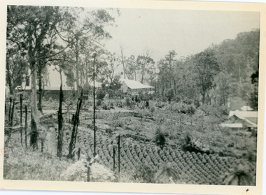
Photograph, View of Kalorama Gap 1905
Kalorama Gap viewed from the South West in 1908. Ellis Jeeves' 'Mountjoy' is in the centre with the stables to the left. The raspberry patch belongs to Harry Walker and the building centre right to Edward Joseph Price. John Lundy-Clarke grew up in the Kalorama/Mt Dandenong area and later in life (1972-74) began to write a comprehensive history of the area working from an original settlement map in an effort to cover all areas.Black and white photograph showing an extensive raspberry crop in the foreground with a house and outbuilding in the centre and another dwelling centre right. Handwritten description on reverse by John Lundy-Clarke. 1908 view of Kalorama Gap taken from corner of Village Settlement LOTS 2 and 3 on Ridge (then Main Road) which crosses centre of picture with Walker’s driveway dropping left. Walker’s raspberry patch in foreground. “Mountjoy” in centre of picture with coaching stables on left. Price’s house and shop on right showing large cross room used by the Village Settlers for dancing. Mrs Hand’s “Beulah Tearooms” later Mt Dandenong North Post Office is above Price’s roof.kalorama gap, kalorama, harry walker, walker, edward joseph price, raspberry, mountjoy -
 Mt Dandenong & District Historical Society Inc.
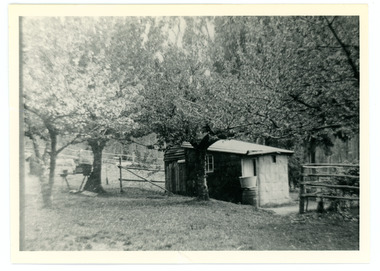
Photograph
French Louis Merci is shown as J.L. Merci on the settlement map, having selected Lot 26 in the Village Settlement in 1901.It was a 5 acre Lot bordering Barbers Road and the Dray Track (now Link Road). Louis shared his hut for some time with Peter the Swede. When Louis became ill with cancer and could no longer work he sold his property to George Barber in return for a weekly payment.Black and white photograph of hut in row of blossoming trees.french louis, louis merci, j l merci, peter the swede, george barber, link road, barbers road, hut, dray track -
 Ballarat Tramway Museum
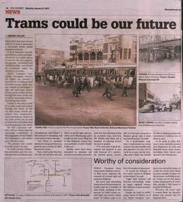
Newspaper, The Courier Ballarat, "Trams could be our future", 21/1/2017
Article by Michael Pollock reporting on a letter to the City of Ballarat about a proposal by Mr Jeff Moran of AWTY Transort Consultants about building a light rail system to serve Ballarat growth areas. Outlines possible routes. Was supported by Mr Bob Lever of the local PTUA. Has photos of a large crowd joining bogie trams outside the Provincial Hotel and two photos of tram accidents. along with a map of the SEC System.Yields information about a proposal to provide light rail to Ballarat.Newspaper cutting from The Courier, Ballarat, 21/1/2017 titled "Trams could be our future".trams, tramways, tram revival, light rail, ballarat, tramway proposals -
 Ballarat Tramway Museum
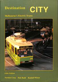
Book, Traction Publications, "Destination City" fifth edition, 1993
Includes brief description of each type, photographs and a summary history, including the Victorian Railway's trams. Has many photographs of the various tramcars associated with relevant text. On front cover is a photo of Z3 at the Burwood terminus. Written by Norm Cross, Dale Budd and Randall Wilson as editors, published by Transit Australia Publishing. Has two maps, north and south of Melbourne, printed on the inside card covers. Published 1993. Yields information up to 1993 about Melbourne's tramcars.Book - "Destination City" with subtitle "Melbourne's Electric Trams" - 128 A4 pages + card card, printed on gloss paper - 7 sections, perfect bound, describes Melbourne's tram car fleet. mmtb, tramways, tramcars, melbourne, vr trams, destination city -
 Kew Historical Society Inc
Plan - Subdivision Plan, Kew Golf Links Estate, 1936, 1936
The Kew Golf Links Estate was a major subdivision in North Kew. It derived its title due to the land being previously occupied by the Kew Golf Club, which transferred its course to a number of locations before occupying its current site. The Plan advertises 180 choice home sites. The street names are somewhat different today as those on the map are named after the proposed Kodak Factory to be built on the site. The subdivision of the Kew Golf Links Estate was a major subdivision of farmland in Kew. The site was at one stage designated for industrial development and the building of a new Kodak factory. The decision by Council to oppose the redevelopment makes the beginning of the period when all industrial development was banned in Kew.Monochrome printed, folded subdivision plan for the Kew Golf Links Estate, to be auctioned on 7 November 1936. Streets named include: Carnegie Avenue, Willsmere Road, Kilby Boulevarde, Kodak Avenue, Coleman Avenue, Beresford Avenue, McConchie Avenue, Cole Avenue, White Avenue, Baker Avenue, Spruzen Avenue, Tanner Avenue, Ratten Avenue, Mathers Avenue, Railway Avenue, Sutherland Avenue, and Belford Road. The position of the Yarra River and a large Drainage Reserve are marked on the plan. Lots for sale are numbered. Existing buildings are designated with a square.subdivision plans - kew (vic), kodak factory - kew (vic)