Showing 11453 items matching "maps "
-
 Port Melbourne Historical & Preservation Society
Document - Report, Plan of General Development, Mr J Green (Government Printer), Plan of General Development, 1929
Plan of General Development. Melbourne Report of Metropolitan Town Planning Commission, 1929. Was passed on by local history librarian as it was no longer required. On p63 shows view up Swallow Street and contrasts it with approach of St Kilda. P42 aerial view of Port Melbourne piers. Also includes maps and photographs.town planning, piers and wharves, swallow street -
 Bendigo Historical Society Inc.
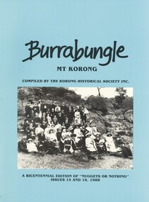
Book - BURRABUNGLE MT KORONG, 1988
Burrabungle Mt Korong compiled by the Korong Historical Society Inc, a Bicentennial edition of '' Nuggets or Nothing '' issues 15 and 16 1988. Published by The Korong Historical Society Inc, contains 57 pages with black and white photographs and maps, blue cover with group photograph picnic at Mt Korong 1912.Betty Ling, Judy Lorraine, Keith Ringbook, rural, shire of korong, shire of korong - history, early settlers, gold discovery, mt korong. -
 Bendigo Historical Society Inc.
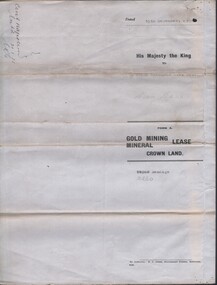
Document - MCCOLL, RANKIN AND STANISTREET COLLECTION: CENTRAL NAPOLEON GOLD MINING CO. N.L, 5th July 1948
Document: Letter from McColl, Rankin & Stanistreet to the Central Napoleon Gold Mining Co N.L. regarding a Residence Licence from Mr R.Roberts, the letter is asking the company whether they have any objections to the request, Land in question is marked on the map contained within the mining lease for document no 2205.704a.organization, business, industry - mining, mccoll rankin & stanistreet, mining, gold mining, central nepoleon, r roberts -
 Bendigo Historical Society Inc.
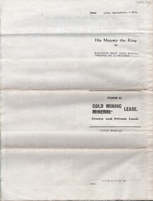
Document - MCCOLL, RANKIN AND STANISTREET COLLECTION: NAPOLEON REEF GOLD MINING CO. N.L, 22 August 1950
Document: 5 Page legal document with map of lease area, Lease No. 11273 Bendigo, Vol.331, Fol. 36453, 15 year lease from 12 December 1949, in vicinity of Inglis, Harvey & Curnow Streets, Signed by Dallas Brooks, Gov of Victoria & J.J. Stanistreet, Mine Manager.organization, business, industrial - mining, mccoll rankin & stanistreet, mining, gold mining, napoleon reef -
 Dutch Australian Heritage Centre Victoria
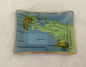
Ashtray (Asbakje)
The item dates from the years of Dutch influence in the region which ended in 1962. The region is now known as West Papua.As the above urls will show, West Papua's history is a complex one with various colonial powers disputing ownership with the local inhabitants. Modern Indonesia also lays claim to it. The area was part of the Kingdom of the Netherlands from 1949 till 1962. Prior to 1949 it was part of the Dutch East Indies. The item may well date from this pre-1949 period.Richly illustrated small rectangular glass ashtray showing map of one-time Dutch New Guinea, surrounding waters and smaller islands. Two endemic bids are also shown. The glas is a pale blue; the illustrations are in green and yellow; words are in black. The ashtray's four sides are curled slightly upwards.Oceans, seas and islands are named in the Dutch language. A dotted border marks off Australian New Guinea. -
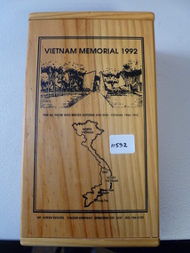 National Vietnam Veterans Museum (NVVM)
Memorabilia, Vietnam memorial 1992
Commemorative wooden box containing a bottle of alcohol and inscribed liquor glass. Lid of box inscribed with map of Vietnam and jungle scenes. Inside of lid inscribed with description of national memorial to the Australian Vietnam Forces. Inside are two metal plaques inscribed "lest we forget" and "Vietnam 1962-1973"As abovememorial wooden box, vietnam memorial 1992 -
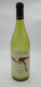 Hume City Civic Collection
Container - Bottle, wine, LONGVIEW CREEK/SUNBURY, 1994
The bottle was donated to the museum by Ron and Joan Parker for use in the exhibition ' A history of the Vineyards in Sunbury' held in the George Evans Museum in 1996. The vineyard was planted in 1992.Conventional bronze green glass bottle with indented base. Cream, gold & maroon printed labels. On the front there is a map impression of Longview Gorge in Sunbury. On the back there is geographical and historical information about the vineyard. There is black cap with a thin gold band at its base which covers the neck and opening of the bottle.Front label: " LONGVIEW CREEK / SUNBURY / PINOT NOIR / 1994 / Produce of Australia"; " S A A 5300" embossed on the glass around the base of the bottle.wines, wineries, longview creek vineyard, longview gorge, parker, joan, winemakers, hodgson, david, ron, george evans collection, 1990s -
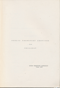 Ballarat Tramway Museum
Document - Report, State Transport Authority (Vic), "Public Transport Services in Ballarat", Jun. 1987
118 page report on Public Transport Services in Ballarat - June 1987. Includes index, Executive summary, cost of services, study results, recommendations, maps, bus timetables and service results. Bound with blue light card cover and plastic clear sheet front and bound with Gestener "Velo Bind"trams, tramways, ballarat, bus services -
 Otway Districts Historical Society
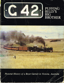
Book, Puffing Billy Preservation Society, G42: Puffing Billy's Big Brother, 1981
Victoria's narrow gauge railways were from Wangaratta to Whitfield (covering 30.5 miles/49 km) opening in 1899, Colac to Beech Forest (29 miles/46.7 km) opening in 1902 with an addition to Crowes (14.1 miles/22.7 km) opening in 1910, Upper Ferntree Gully to Gembrook (18.2 miles/29.3 km) opening in 1900, and Moe to Walhalla (26 miles/41.3 km) opening in 1910. From the outset these narrow gauge lines proved very uneconomical in operation and were plagued with continuing financial losses. The lines most difficult to work were those carrying the most business, and in particular the trains from Colac and Moe with their 1 in 30 grades and countless curves precluded having engines with large coupled driving wheels operating. Having examined the possible use of articulated locomotives to reduce operating costs on the narrow gauge lines the Victorian Railways decided upon the Beyer-Garratt type of locomotive in 1925 and an order was placed in England for two engines of the 2-6-0 plus 0-6-2 wheel arrangements. These arrived in April 1926. Assembly of the new Garratts was duly completed and steaming trials carried out at Newport, Victoria, the engines being classed as "G" and given the running numbers "41" and "42". G41 was taken to Colac where, on 5 June 1926, it was put to work on the Colac-Beech Forest-Crowes line. G42 soon followed and duly began work on the equally steep and tortuous but shorter Moe-Walhalla line. Following the closure of the Moe line in 1955 G42 was refurbished and went to Colac. G41 was overhauled, but not as thoroughly as G42, at then returned to Colac where both Garratts shared regular work on the line until its closure in 1962. From 1978 G42 continues its operation on the Upper Ferntree Gully-Gembrook line as part of the Puffing Billy Preservation Society.G42: Puffing Billy's Big Brother. Pictorial history of a Beyer-Garratt in Victoria, Australia. Phil A'Vard, Larry James, Ron Peach (concept). Puffing Billy Preservation Society; Belgrave (Vic); 1980. 64 p.; illus; map. Soft cover. ISBN 0 9598392 7 5victorian railways; narrow gauge; moe; walhalla; colac; beech forest; crowes; upper ferntree gully; gembrook; beyer-garratt; -
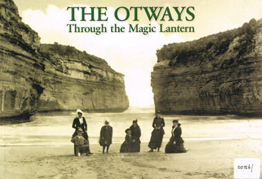 Otway Districts Historical Society
Book, Colac and District Historical Society, The Otways through the magic lantern, 2013
George Sydenham was appointed as Colac Shire Valuer and rate collector in 1890 which threw him into direct contact with the Otway people at a time when the first selectors were suffering badly. He would have heard their frustrations and grievances in great detail. When Secretary to the Colac Committee for the Railway Extension to Beech Forest he used his magic lantern slide shows from 1896 to support his case for a railway, by lauding the place and its potential, both for settlement and for timber production.The Otways through the magic lantern: commentary and glass slides of George Sydenham - lecture held in 1896. George Francis Sydenham. 1st ed. Colac (Vic); Colac and District Historical Society; 2013. iv, 118 p.; illus., map. ISBN 9780 6469 122 02 Soft cover.colac: otway ranges; history; coasts; -
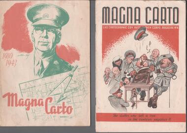 Bendigo Historical Society Inc.
Magazine - THE BROOK AND ANDERSON FORTUNA COLLECTION: MAGNA CARTO MAGAZINE
Two copies of the Magna Carto Magazine of the Australian Survey corps. Issue two and four. Issue two has a drawing of a soldier and a map and compass with the words 1910-1943 on the cover. Issue four has a group of soldiers around a table with the words ''the duffer who left a tree in the contour negative!!''.military, world war 2 -
Kew Historical Society Inc
Archive (series) - Subject File, Victoria Park : Concept Management Plan, Research Papers, 2004, 2004
Graeme Butler & AssociatesProject FilesProvenance OrderRed cardboard wallet containing historical research by Graeme Butler, heritage architect, into the history of Victoria Park, Kew. The file also includes a draft Victoria Park Concept Master Plan, 2004. The research includes memoranda, maps, photocopies of plans, forms, notes, aerial photos, and sundry references.graeme butler - heritage architect, victoria park - kew (vic), heritage studies - kew (vic.)graeme butler - heritage architect, victoria park - kew (vic), heritage studies - kew (vic.) -
 Bacchus Marsh & District Historical Society
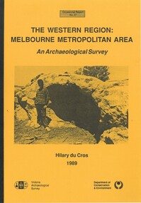
Book, The Western Region: Melbourne Metropolitan Area: An Archaeological Survey
This study aimed to locate and document Aboriginal archaeological sites in the western region of Melbourne. This area was defined by the study as extending out from the western suburbs of Melbourne to the Brisbane Ranges and north beyond Bacchus Marsh. The specific aim of the study was to investigate the Aboriginal archaeology of the Western Plains area in the vicinity west of Melbourne. The Bacchus Marsh, Melton and Werribee shire boundaries of the time defined the areas of the study. The study contains extensive lists of the types of artifacts found the the locations where they were found.Soft cover foolscap size book. 96 pages with b & w illustrations, images and maps (some folded). Part of Occasional reports series (Victoria Archaeological Survey) ; No. 27. Published by Department of Conservation and Environment, Melbourne, 1990. Author, Hilary Du Cros. BMDHS Loc. AR/SU5This study aimed to locate and document Aboriginal archaeological sites in the western region of Melbourne. This area was defined by the study as extending out from the western suburbs of Melbourne to the Brisbane Ranges and north beyond Bacchus Marsh. The specific aim of the study was to investigate the Aboriginal archaeology of the Western Plains area in the vicinity west of Melbourne. The Bacchus Marsh, Melton and Werribee shire boundaries of the time defined the areas of the study. The study contains extensive lists of the types of artifacts found the the locations where they were found. aboriginal australians victoria western plains, aboriginal artifacts, archaelogical sites victoria western plains, aboriginal artifacts bacchus marsh region -
 Bendigo Historical Society Inc.
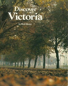
Book - DISCOVER VICTORIA, 1979
Discover Victoria by Bob Moors, soft cover 104 pages with maps, black and white & colour illustrations, published by Decalon Pty Ltd Melbourne. This book, with the compliments of The Department of State Development, Decentralization and Tourism is designed to introduce you to the many tourist attractions in the twelve regions of Victoria, the garden state.victoria, history, people and places in victoria. -
 Bendigo Historical Society Inc.
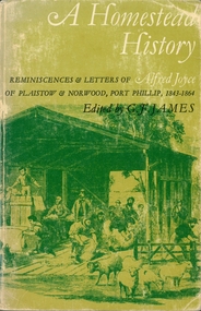
Book - A HOMESTEAD HISTORY
A Homestead History, reminiscences & letters of Alfred Joyce of Plaistow & Norwood, Port Phillip, 1843-1864 edited by G. F. James. Soft cover book of 206 pages with maps, black and white photographs & illustrations, edited by G.F. James published by Oxford University Press, 3rd edition 1969.Name written in ink inside cover Harold Curnow 24/11/69history, australian, joyce -
 Bendigo Military Museum
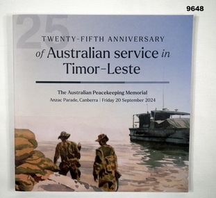
Book - ANNIVERSARY, Australian Government Department of Veteran Affairs, "TWENTY-FIFTH ANNIVERSARY OF AUSTRALIAN SERVICE IN TIMOR-LESTE", 2024
From the front cover; "TWENTY-FIFTH ANNIVERSARY/ of Australian service in / Timor-Leste/ The Australian Peacekeeping Memorial/ Anzac Parade, Canberra/ Friday 20 September 2024".Soft Cover book. Cover - cardboard, with dark blue print on front and back. Illustrated - in colour, artwork - "Dili Wharf by Rick Amor 1999". 60 pages - cut, plain, white paper. Illustrated colour and black and white photographs, maps and flags. Front and back end papers illustrated.publication, book, peace keepers, timor-leste -
 Bendigo Historical Society Inc.
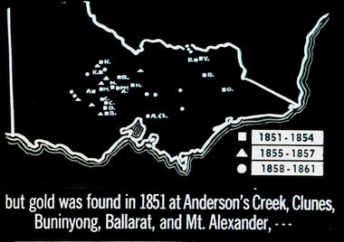
Slide - DIGGERS & MINING. THE GOLD ERA, c1851
BHS CollectionDiggers & mining. But gold was found in 1851 at Anderson's Creek, Clunes, Buninyong, Ballarat, and Mt. Alexander, - - - Slide shows map of Victoria with legend to show when gold was found in different areas. The gold era. Markings 4 994.031 GOL:5. Used as a teaching aid. Used as a teaching aid.hanimounteducation, tertiary, goldfields -
 Bendigo Historical Society Inc.
Document - BASIL MILLER COLLECTION: MAP - CHARING CROSS
Map showing Charing Cross, Bendigo area. Details written suggest plans for an ANZAC Day Service. Cream coloured paper and black print with additions written by hand in blue ink. Numerous markings in blue ink on front. 'the Manager, SEC, Hargreaves Street Bendigo, ref. Tramways' on reverse.basil miller, bendigo trams, state electricity -
 Bendigo Military Museum
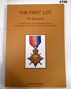
Book - BOOK, BIOGRAPHY 7th Battalion First World War, Bendigo Modern Press, "The First Lot 7th Battalion", 2014
"The First Lot - 7th Battalion" The first men of the Bendigo district to volunteer for service in the First World War. Biography.Soft cover book, Soft cover, light weight cardboard, dark brown print on front, spine and back. Dark yellow colour background, illustrated on front in colour. 1914-15 medal and ribbon. 297 pages, cut plain, white, illustrated black and white photographs and maps. Biography."The First Lot - 7th Battalion" The first men of the Bendigo district to volunteer for service in the First World War. Biography.books, biography, ww1, army -
 Melbourne Tram Museum
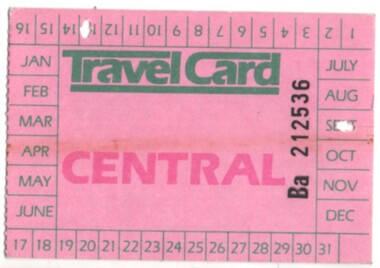
Ephemera - Ticket/s, The Met, Travel card Central, c1980's
The Met travel cards, Travel card Central, Travelcard large size, printed on pink card, tickets for the 1987 to 1989 era for central area, unpriced.. Availability dates printed on ticket but not the year. Later versions printed with the price. Conditions of use and map showing the area available printed on rear.trams, tramways, tickets, the met, ptc, travel cards -
 Ringwood and District Historical Society
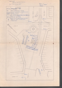
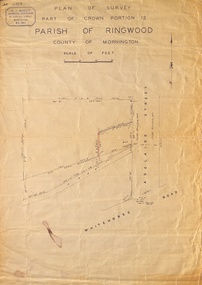
Map, Plan of Survey, Part of CP12, Adelaide Street, Ringwood, Circa 1920s
Undated map of part of commercial area in Parish of Ringwood, County of Mornington showing Adelaide Street, Whitehorse Road, and un-named laneway behind Whitehorse Road shops marked as Road, and New Road Alignment. Made by H.J. Macey, Licensed Surveyor 36 Narissa Street Burwood BX1917. -
 Alfred Hospital Nurses League - Nursing Archive
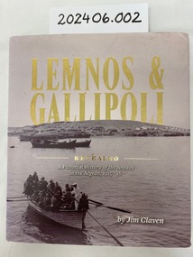
Book - Illustrated book, Jim Claven, Lemnos & Gallipoli revealed : a pictorial history of the ANZACs in the Aegean, 1915-1916
The story of the Hellenic connection to Australia's Gallipoli story. Lemnos was the advance base for the Gallipoli campaign.Hardcover book. Title in gold print. Cover photo, black and white image of first party of officers proceeding from SS Simla to land on Lemnos Island, this is on the dust jacket. Author name printed on front of book and jacket. 352 pages, including over 300 labelled photographs and maps.non-fictionThe story of the Hellenic connection to Australia's Gallipoli story. Lemnos was the advance base for the Gallipoli campaign.wwi, lemnos, gallipoli, ahnl, grace wilson -
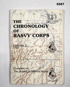 Bendigo Military Museum
Booklet - The Chronology of the Royal Australian Survey Corps - Ed2 1985, School of Military Survey, Bonegilla, Vic, 24.06.1985
This is the second Edition of the "Chrology of the Royal Australian Survey Corps" produced in 1985 by the officers at the School of Military Survey (SMS). The First Edition produced in 1979 was also produced at the SMS. Since the first edition was produced, a definitive history of the Corps has been published by Brigadier Fitzgerald in his book "Lebanon to Labuan" in 1980 and is the story of the Corps during WWII. This new edition has been completely revised and updated. In order that amendments for future editions may easily be made, this document has compiled on computer. Signed LTCOL JG Corless Commanding Officer SMS. Future and final editions of the History of the Royal Australian Survey Corps have used this document as part of their research.A5 paper booklet, 56 x pages and stapled. Cover is a printed map with title and printed versions of the initial Australian Survey Corps Badge, the "King's and Queen's Crown" versions of the Royal Australian Survey Corps badges. The booklet contains computer text and poor quality B/W photographs.Compiled and printed by the School of Military Surveyroyal australian survey corps, rasvy, fortuna, army survey regiment, army svy regt, school of military survey -
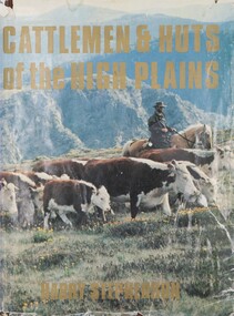 Falls Creek Historical Society
Book - Cattlemen & Huts of the High Plains, Harry Stephenson, 1980
This book records the development of Victoria's alpine regions by the pioneer cattlemen. They came from the Monaro in the 1830s to reach the Plains of Omeo while others advanced up the Murray tributaries to discover the Bogong High Plains in the 1830s and the Gippslanders moved their herds to Alpine pastures in the 1860s. The cattlemen, the snow plain pastures, the mountain scene and the bush huts are described and illustrated in this volume. It records an era in Australia whose story is becoming lost.This volume of 350 pages includes 34 maps, 326 illustrations and diagrams. It has a brown cloth with white lettering and a pictorial jacket featuring cattlemen on the High Plains. It includes an index and bibliography. The front page has an inscription which indicates it had been given to Ore Frueauf of Falls Creek.non-fictionThis book records the development of Victoria's alpine regions by the pioneer cattlemen. They came from the Monaro in the 1830s to reach the Plains of Omeo while others advanced up the Murray tributaries to discover the Bogong High Plains in the 1830s and the Gippslanders moved their herds to Alpine pastures in the 1860s. The cattlemen, the snow plain pastures, the mountain scene and the bush huts are described and illustrated in this volume. It records an era in Australia whose story is becoming lost.victorian high country, mountain cattlemen, victorian high plains -
 Bendigo Historical Society Inc.
Map - UNITED HUSTLER'S & REDAN MINE - TRANSVERSE SECTIONS N & S OF SHAFT UNITED HUSTLER'S & REDAN MINE
Transverse Sections N & S of Shaft United Hustler's & Redan Mine on the Hustler's Line of Reef Bulletin No 33, Plate No XXX. Map shows some of the stone encountered on the levels and depth. Geological Survey of Victoria emblem and signed by H A Whitdan, Underground Survey Office Bendigo, September 1913.mining, parish map, united hustler's & redan mine, transverse sections n & s of shaft united hustler's & redan mine, hustler's line of reef -
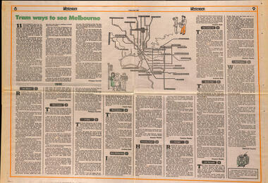 Melbourne Tram Museum
Newspaper, The Age, "Tram ways to see Melbourne", 8/5/1981
... Maps ...Newspaper clipping, from The Age, Weekender, Friday 8/5/1981 titled "Tram ways to see Melbourne", with a number of writers giving a short piece on a particular line. Has a Map of the Melbourne system with destination and route numbers. Has an introduction written by Phillipa Hawker which looks at the history, its place in Melbourne, and possibilities for the future. Written just before the MTA came into existence. Items: East Malvern, Route 3, Rebecca Batties West Preston Route 10, Phillipa Hawker St Kilda, Route 12, Frank Prain North Balwyn, route 48, Andrew Bolt West Maribyrnong route 57, Rosslyn Beeby Essendon Airport, Route 59, Rosslyn Beeby Carnegie, Route 67, Andrew Bolt Kew Cotham Rd, route 69, Andrew Bolt Wattle Park, route 70, Rosslyn Beeby East Burwood, route 75, Rosslyn Beeby East Preston, route 88, Deborah Forster Has some sketches of trams and people.trams, tramways, melbourne, people and places, tourism, east malvern, west preston, st kilda, north balwyn, west maribyrnong, essendon airport, carnegie, kew- cotham rd, wattle park, east burwood, east preston, route 3, route 10, route 12, route 48, route 57, route 59, route 67, route 69, route 70, route 75, route 88, maps -
 Eltham District Historical Society Inc
Negative - Photograph, J.A. McDonald, Eltham, Haldane Road, Mar. 1961
Dr Donald Thomson's gate and entrance to his property 'Worlingworth' after flooding in March 1961 "Worlingworth", Eltham, was the home of noted anthropologist the late Professor Donald Thomson and his wife Dorita. The entrance gate on Banoon Road is located at the bottom of the hill opposite Haldane Road. The flooding issues were regularly reported to Council following heavy rain. Google Street View Feb 2014 https://goo.gl/maps/SGjsJAAEdjQXgo5V9Record of various Shire of Eltham infrastructure works undertaken during the period of 1952-1962 involving bridge and road reconstruction projects, sometimes with Eltham Shire Council Project Reference numbers quoted. It was during this period that a number of significant improvements were made to roads and new bridges constructed within the shire that remain in place as of present day (2022). In many situations, the photos provide a tangible visible record of infrastructure that existed throughout the early days of the Shire. The album was put together by or under the direction of the Shire Engineer, J.A. McDonald.infrastructure, shire of eltham, 1961-03, flood damage, haldane road, prof donald thomson, worlingworth -
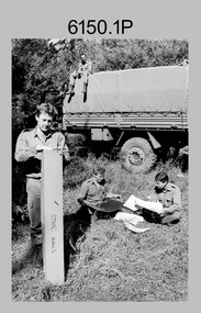
 Bendigo Military Museum
Photograph - Photographic Technicians performing tasks at the Army Survey Regiment, c1970s
These eleven photographs were most likely taken in the 1970s in Lithographic Squadron at the Army Survey Regiment, Fortuna, Bendigo. Although Photo .1P is not annotated the remainder have the technician’s name written on the back. The equipment operated by the technicians is not identified. The dates are unknown but most of these photos were probably taken the late 1970s. The main tasks undertaken by the technicians were most likely enlargements, reductions and duplication of map reproduction material, and aerial photography.This is a set of photographs of technicians operating photographic reproduction equipment at the Army Survey Regiment, Bendigo c1970s. The photographs were printed on photographic paper and are part of the Army Survey Regiment’s Collection. The photographs were scanned at 300 dpi. .1) - Photo, black & white, c1970s, unidentified, Lithographic Squadron .2) - Photo, black & white, c1970s, Gary Drummond, Lithographic Squadron .3) - Photo, black & white, c1970s, John Scott, Lithographic Squadron .4) - Photo, black & white, c1970s, WILD U4A Diapositive Camera, Bob Chamberlain, Lithographic Squadron. 5) - Photo, black & white, c1970s, WILD U4A Diapositive Camera, Zoe (Lisiewich) Ames, Lithographic Squadron .6) - Photo, black & white, c1970s, Garry Hudson, Lithographic Squadron .7) - Photo, black & white, c1970s, Garry Hudson, Lithographic Squadron .8) - Photo, black & white, c1970s, Garry Hudson, Lithographic Squadron .9) - Photo, black & white, c1970s, Mick Ellis, Lithographic Squadron .10) - Photo, black & white, c1970s, Col Darch, Lithographic Squadron .11) - Photo, black & white, c1970s, Phil Beatty, Lithographic Squadron.1P – no annotation .2 to .11 – personnel names (less rank) annotated on back. royal australian survey corps, rasvy, army survey regiment, army svy regt, fortuna, asr, litho -
 Bendigo Military Museum
Photograph - Lithographic Squadron Regimental Training, Army Survey Regiment, Bendigo, 1989
This is a set of 24 photographs of Army Survey Regiment’s Lithographic Squadron personnel undertaking regimental training in an unknown location in April 1989. The purpose of the training was probably to provide personnel a practical knowledge of navigation and map reading, RATEL and Survival in the Field, vehicle camouflage, teamwork and leadership. The training did not include infantry and minor tactics due to the absence of weapons. Although these photos are not annotated other than the month and year, most personnel are positively identified.This is a set of 24 photographs of personnel from Lithographic Squadron, Army Survey Regiment, Fortuna, Bendigo, undergoing regimental training in April 1989. The photographs were on 35mm negative film and scanned at 96 dpi. They are part of the Army Survey Regiment’s Collection. .1) - Photo, black & white, 1989, background L to R: Frank Lenane, Bill Jones, foreground L to R: Gavin McLean, Colin Yeats, Peter Dillon. .2) - Photo, black & white, 1989, Rhys De Laine. .3) - Photo, black & white, 1989, L to R: Peter Breukel, Colin Yeats. .4) - Photo, black & white, 1989, L to R: Colin Yeats., Peter Dillon. .5) - Photo, black & white, 1989, L to R: Graeme Spong, Gavin McLean, unidentified (x2), Peter Breukel, Steve Burke, Bill Jones, Colin Yeats. .6) - Photo, black & white, 1989, L to R: Graeme Spong, Bill Jones, Colin Yeats, Peter Dillon, Peter Breukel, Steve Burke, Colin Yeats. .7) - Photo, black & white, 1989, L to R: Graeme Spong, Bill Jones, Colin Yeats, Peter Dillon, .8) - Photo, black & white, 1989, Colin Yeats. .9) - Photo, black & white, 1989, L to R: Gavin McLean, Colin Yeats. .10) - Photo, black & white, 1989, L to R: Steve Burke, Peter Breukel, Colin Yeats, unidentified. .11) - Photo, black & white, 1989, L to R: Steve Burke, Peter Breukel. .12) - Photo, black & white, 1989, L to R: Peter Breukel, Steve Burke. .13) - Photo, black & white, 1989, Craig Hersant. .14) - Photo, black & white, 1989, L to R: Rob Bogumil, Darren Maher, Paul Baker, Rob Jones, Shona Hastie, unidentified, Chad Hardwick. .15) - Photo, black & white, 1989, L to R: Chad Hardwick, unidentified, Rob Bogumil, Rob Jones, Darren Maher, unidentified, Paul Baker. .16) - Photo, black & white, 1989, L to R: Rob Bogumil, Darren Maher, Chad Hardwick, Rob Jones, unidentified (x2), Paul Baker. .17) to .22) - Photo, black & white, 1989, unidentified personnel applying camouflage to truck. Shona Hastie in truck, .23) - Photo, black & white, 1989, L to R: LT Dave Weston, LT Craig Hersant, Trevor Osborne, Bill Jones. .24) - Photo, black & white, 1989, L to R: Andrew Arman, unidentified, Peter Dillon, Steve Burke, Colin Yeats, Peter Breukel. No personnel are identified. Annotation dated April 1989.royal australian survey corps, rasvy, army survey regiment, army svy regt, fortuna, asr, litho -
Stawell Historical Society Inc
Book - Science, The Natural History of Western Victoria, 1974
Reports from Symposium of Australian Insitutes of Agricultural Science, held in Horsham 1971. 8 chapters, 7 of science 8th extracts from Stapylton's Journal of Western Victoria, when travlling with Major Mitchell. Contains fold out Maps & photos. 1) Geology & Geomorphology 2) Soils 3) Vegitation 4) Birds 6) Aborigines 7) the first hundred years of agricultural development 8) The Journal of Granville William Chetwynd StapyltonSoft Yellow Cover and Black with Black taped spineBarry Clugston