Showing 815 items matching " aerial views"
-
 Department of Energy, Environment and Climate Action
Stereoscope
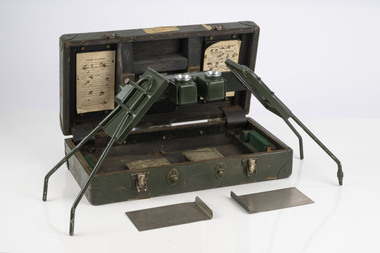
This stereoscope was used to view a pair of separate and overlapping aerial photos as a single three-dimensional image. Smaller units and could be easily used in the field but this larger, mirror stereoscope was used in offices. The aerial images were used to map forest types, timber stands, new roads and tracks, firebreaks, boundaries of timber harvesting, plantations, bushfires, insect and disease attack and so on In 1928, the Forests Commission undertook its first major aerial photography project over 15,000 acres of forest which is said to be the first of its kind in Australia. During the Second World War, large areas of Victoria were photographed by RAAF and used to produce orthophoto maps. By 1945 aerial photography of 13,000 square miles (3.4 M ha) was completed, including much of the inaccessible eastern forests. The Forests Commission started developing its own small format photography in the early 1970s. Simple, cheap and rapid methods of obtaining photographs using 70mm and 35mm cameras were developedFoldable metal stereoscope in wooden box with mirror covers Ex Dept of Defenceforests commission victoria (fcv), surveying, forest measurement -
 Port Melbourne Historical & Preservation Society
Photograph - Aerial view of Port Melbourne, 23 Dec 1945
... Aerial view of Port Melbourne... located in A.06.04.B4) Photograph Aerial view of Port Melbourne ...One of three prints of aerial photographs of Port Melbourne 23.12.1945, showing different areas and to different scales: this one vertical, takes in Station and Town Piers, railyards, Missions to Seamen, Engine Works, temporary US wartime structures, edge of COR buildings, Swallow & Ariell, portion of Wiilliamstown Road. (Smaller copies located in A.06.04.B4)piers and wharves - station pier, piers and wharves - town pier, war - world war ii, built environment, transport - railways, missions to seamen, swallow & ariell ltd -
 Stawell Historical Society Inc
Photograph, Stawell Industrial Area Aerial View with the Woollen Mills, Stawell Timber Industry & Pleasant Creek Hospital
... Stawell Industrial Area Aerial View with the Woollen Mills... Aerial View with the Woollen Mills, Stawell Timber Industry ...Aerial Photograph Woollen Mills, Stawell Timber Industry, Pleasant Creek Hospital, Oval,.industry -
 Port Melbourne Historical & Preservation Society
Photograph - Aerial view of Swallow and Ariell factory, Port Melbourne, c. 1950
... Aerial view of Swallow and Ariell factory, Port Melbourne... building visible on right hand side of photo Photograph Aerial view ...The Sandridge Marine Lodge was founded in 1858. Two locations; originally Stokes St and then in Liardet St from 1917. Both buildings are now converted to apartments. .03 - Aerial photo of Swallow and Ariell factory, with Stokes St Lodge building visible on right hand side of photobuilt environment - civic, built environment - domestic, societies clubs unions and other organisations, built environment - industrial, freemasons lodge, swallow & ariell ltd, sandridge marine lodge -
 Linton and District Historical Society Inc
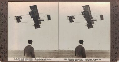
Stereograph, The Rose Stereographs, Melbourne, Sydney, Wellington and London, 12,933 The Allies' Aerial Service, Flanders, Copyright 1914
One of two sets of stereographs donated by the O'Beirne family along with a stereoscope for viewing (Stereoscope is Registration no. 2014-51).Man in foreground watching a biplane flying overhead."12,933. THE ALLIES' AERIAL SERVICE. A Bi-plane Leaving the British Lines / on Scouting Work in Flanders."stereographs -
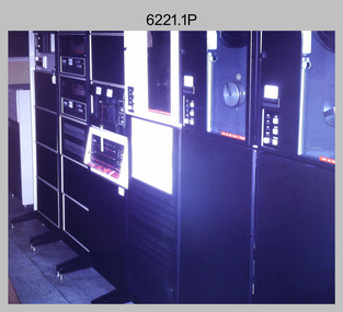 Bendigo Military Museum
Photograph - Aerotriangulation Production – Army Survey Regiment, Fortuna, Bendigo, c1970s to 1980s
This collection of 14 photos was most likely taken in the 1970s and 1980s in Air Survey Squadron. The PDP 11/70 minicomputer shown in photo .1P was the operating system introduced in 1977 as the mainframe system for the control of the APC4, aerial triangulation block adjustments, SORA OP Analytical Orthophoto control, APR Analytical Terrain Profile Recorder computation, graphics, and general computing. Technicians used the Wild A9 Stereocomparator shown in photo .2P to accurately measure between pass, tie, and survey control points on aerial photographs. The Zeiss D2 Planimat Stereoplotter shown in photos .3P to .4P was used for analytical orthophoto control. It was introduced in 1972-1973 The Zeiss (Jena) Stecometer analytic stereocomparator for air photography shown in photos .5P to .11P and .14P was introduced at Air Survey Squadron in 1963. Aerotriangulation production was expedited using computers for analytical photogrammetric processes. The technician accurately measured between pass, tie, and survey control points on aerial photographs. Wild PUG4 point transfer devices shown in photos .12P to .13P were introduced in c1968 superseding the PUG2 devices. PUG4 devices were used by technicians to stereoscopically view the photography containing the survey control points and the mapping aerial photography. The Control points were transferred from the control photography to the mapping diapositives of aerial photography by drilling their locations into the photographic emulsion.This is a set of 14 photographs of Air Survey Squadron personnel operating aerotriangulation equipment at the Army Survey Regiment at Fortuna, Bendigo, c1970s to 1980s. Photographs .1P to .13P were on 35mm colour slide film and scanned at 96 dpi. Photograph.14P was printed on photographic paper and was scanned at 300 dpi. They are part of the Army Survey Regiment’s Collection. .1) - Photo, colour, c1979, PDP-11 minicomputer. .2) - Photo, colour, c1970s, Unidentified technician operating a Wild A9 Stereocomparator. .3) - Photo, colour, c1970s, Zeiss D2 Planimat Stereoplotter. .4) - Photo, colour, c1970s, Zeiss D2 Planimat Stereoplotter, unidentified technicians. .5) - Photo, colour, c1970s, Zeiss D2 Planimat Stereoplotter, SGT Christopher Wardley. .6) - Photo, colour, c1970s, Zeiss D2 Planimat Stereoplotter. .7) to.9) - Photo, colour, c1970, Zeiss (Jena) Stecometer, unidentified technicians. .10) to.11) - Photo, colour, c1988, SPR Toni Wright operating a Zeiss (Jena) Stecometer. .12) - Photo, colour, c1970s, Wild PUG4 point transfer device, SPR John Shepard. .13) - Photo, colour, c1970s, Wild PUG4 point transfer device, SPR David Edwards. .13) - Photo, colour, c1970s, Wild PUG4 point transfer device, SPR David Edwards. .14) - Photo, colour, c1980, Zeiss (Jena) Stecometer, SGT Bruce Hammond.Some of the equipment is annotated on the frame of the 35mm slides.royal australian survey corps, rasvy, army survey regiment, army svy regt, fortuna, asr, aerotrig, photogrammetry -
Merbein District Historical Society
Photograph, Aerial view Merbein blocks & Murray River flood (framed), unknown
... Aerial view Merbein blocks & Murray River flood (framed)... Merbein township Murray River Aerial view Merbein blocks & Murray ...merbein township, murray river -
 Federation University Historical Collection
Photograph, Aerial View of Camp Street, Ballarat
... Aerial View of Camp Street, Ballarat... Former Ballarat Courthouse Aerial View of Camp Street, Ballarat ...camp street, arts academy, deakin place, alfred deakin place, art gallery of ballarat, ballarat state officers, former ballarat library, ballarat trades hall, george hotel, regent theatre, former ballarat courthouse -
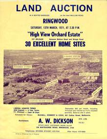 Ringwood and District Historical Society
Flyer, Land Auction Sale Brochure, High View Orchard Estate, Ringwood, Vic. - 1971
Double-sided advertisement for Ringwood High View Orchard Estate land auction sale on Saturday, 13th March, 1971, including aerial photograph, map, and summary of local facilities and services.Subdivision includes Wonga Road, Oban Road, Sang Court, Ambrie Avenue, Hendra Grove, and Mullum Mullum Road. Agent - A.W. Dickson Pty. Ltd., 136 Whitehorse Road, Ringwood, 3134. Telephones: 870 6000, 870 6007, 870 7016, after hours 870 6868. A separate copy of the advertisement includes a local newspaper follow-up clipping reports thirty home sites grossing $102,350 at the auction. -
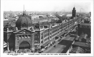 Melbourne Tram Museum
Postcard, Rose Stereograph Co, "Flinders Street Station and the Yarra, Melbourne", late 1920s
... in Flinders Street. Yields information about an aerial view ...Rose Series postcard No. P 1666, titled "Flinders Street Station and the Yarra, Melbourne". This photo is looking southwest from St Paul's Cathedral over the station building along the Yarra river. The St Kilda/Port Melbourne and Queens bridge are in view, but not the Spencer St bridge which was built during the late 1920s. The AW Allen's Limited Confectionary Factory constructed in 1923-24 on Riverside Avenue dominates the landscape on the south side of the river directly behind the dome of the Flinders Street railways station. One very long set of horse-drawn carts can be seen alongside the center entrance to the railway station building in Flinders Street.Yields information about an aerial view of Melbourne late 1920sPostcard - printed real photograph with Rose Stereograph Co. name on the rear.tramways, trams, flinders st station, yarra river, bridges, railways, flinders st -
 Melbourne Tram Museum
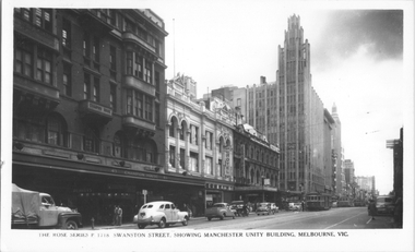
Postcard, Rose Stereograph Co, "Swanston Street, showing Manchester Unity Building, Melbourne", late 1940s
... around 1972. Yields information about an aerial view of Melbourne ...Rose Series postcard No. P 1718, titled "Swanston Street, showing Manchester Unity Building, Melbourne", Photo looking north along Swanston Street from Flinders Lane. Has a one W2 class, one W5 class and one W4 class tramcar in view. The Manchester Unity Building, Capital Theater and the Century Building all dominate the streetscape between Collins and Little Collins Streets. The Champion Building on left of the photo was built around 1923 and demolished around 1972. Yields information about an aerial view of Melbourne late 1930sPostcard - printed real photograph with Rose Stereograph Co. name on the rear.tramways, trams, swanston st, manchester unity building, w2 class, w5 class, w4 class -
 Melbourne Tram Museum
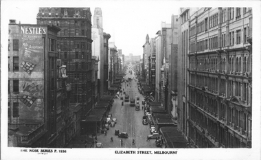
Postcard, Rose Stereograph Co, "Elizabeth Street, Melbourne", early 1940s
... information about an aerial view of Melbourne early 1940s tramways ...Rose Series postcard No. P 1936 titled "Elizabeth Street, Melbourne". Photo taken from the tower at Flinders Street Railway station, looking north along Elizabeth Street. Has several W5 class trams in the view with white panels under the driver's windows. Yields information about an aerial view of Melbourne early 1940sPostcard - printed real photograph with Rose Stereograph Co. name on the rear.tramways, trams, elizabeth st, world war ii, w5 class -
 Melbourne Tram Museum
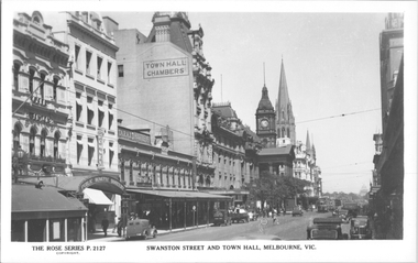
Postcard, Rose Stereograph Co, "Swanston St and Town Hall Melbourne", late 1930s
... about an aerial view of Melbourne late 1930s tramways trams ...Rose Series postcard No. P 2127, titled "Swanston St and Town Hall Melbourne", looking south from Bourke St with the Shrine of Remembrance in the distance. Three W2 class trams visible along with the Safety Zone sign for the Bourke St tram stop. Yields information about an aerial view of Melbourne late 1930sPostcard - printed real photograph with Rose Stereograph Co. name on the rear.tramways, trams, swanston st, town hall, w2 class -
 University of Melbourne, Burnley Campus Archives
Album - Black and white and colour prints, Brian Ward, Freeway Construction, 1963-1972
(1) 14 black and white photographs showing views of where the Freeway would be going through near Burnley Gardens. (2) 2 photographs of views of the Yarra River near Burnley Gardens. (3) Aerial photograph of construction of the Freeway near Burnley Gardens and Yarra Boulevard. (4) 8 colour photographs of construction work in and over the River Yarra near the railway bridge. "Brian Ward Freeway Construction" handwritten on cover of folder. Student Dux 1973.freeway, burnley gardens, yarra river, yarra boulevard, river yarra, brian ward, aerial photographs -
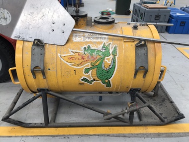 Department of Energy, Environment and Climate Action
Aerial Drip Torch (ADT) or "Dragon"
... ://drive.google.com/file/d/1CKtcH-3rUlrtbE9dkNP27PYT2-raVVhF/view ] Aerial ...The Aerial Drip Torch (ADT) was an idea conceived in Canada in the 1970s by John Muraro It was developed in 1982 by the New Zealand Forest Service to become the Ashley Aphid Helitorch. Forestry Tasmania acquired one of the machines and modified it in February 1987. Also known as a dragon helitorch it consisted of a large 135-litre tank containing jellied petrol, a displacement pump, propane ignition system, burner nozzle and fire extinguisher system. It was first trialled in Victoria at Swifts Creek in 1991 and the Aerial Drip Torch (ADT) has now become standard practice.Two Aerial Drip Torches (ADTs) were built in the 1990s by the Fire Equipment Development Centre at North Altona, They were developed in conjunction with the Department of Conservation and Land Management in Western Australia. The first was trialled during the 1991/92 autumn burning season. The machine proved to be successful and a second machine was introduced in 1998 to assist with burning operations across the State. The ADTs were commonly used for regeneration burning (controlled burning of logging slash). The first ADT introduced in 1992 had a dry weight of 160kg and a capacity of 130 litres, providing about an hour of operation. Following initial use, systematic modifications were adapted including improved ignition of gel at the drop tube, installation of an air bleed valve at the pump to assist pump priming and improved mounting brackets for the CO2 bottles and propane canister attached to the machine. The second, and lightweight ADT, introduced in 1998 had a dry weight of 68kg and a capacity of 200 litres due to a smaller lightweight frame and plastic (Polyfin) tank. In operation the ADT is suspended below a helicopter via four strops attached to the vessel and a cable to the helicopter cargo hook. Gelled fuel is dispensed via a drop tube which is attached to the pump outlet of the machine, and ignited via a gas torch. Safety features built into the first ADT were: a brass melting plug designed to be activated at 200 C bursting disc designed to burst at170 Kpa should the vessel over pressurise. a pressure relief valve set to 35 Kpa ( vessel operated between 16 &34 Kpa) a low pressure sensor designed to shut down the machine should the vessel pressure drop below 15Kpa. the vessel is filled with CO2 above the gelled fuel to eliminate ignition with in the vessel. CO2 is used to expel any residue of ignited gel from the drop tube to prevent ignition when flying outside the boundaries of the burning area. See FIRE EQUIPMENT NOTE - 46 [ https://drive.google.com/file/d/1CKtcH-3rUlrtbE9dkNP27PYT2-raVVhF/view ]forests commission victoria (fcv), bushfire, bushfire aviation, planned burning -
City of Kingston
Photograph - Colour, Circa 1993
Edithvale is a suburb in the City of Kingston. It is located between Aspendale and Chelsea on the Port Phillip Bay and built within remnant areas of the Carrum Carrum swamp. The foreshore precinct comprises a wide sandy beach, with low sand dunes and numerous historic boat sheds. The suburb consists of older style dwellings and former holiday houses, combined with mid-century housing and newer homes. The large blocks are increasingly subdivided and the existing dwellings demolished to accommodate units and townhouses, thus changing the landscape of the area and reducing the tree canopy.The beachside suburb of Edithvale was previously part of the extensive Carrum Carrum Swamp. The area was once a source of fish and eels for the Mayone-Bulluk clan of the Bunurong people. Over time the area was drained and predominantly devoted to dairy farming and holiday houses. The farms were gradually sold and subdivided with a large number of homes built after World War II and in the 1960s. Edithvale is mainly residential with a shopping strip along Nepean Highway but little significant industry was ever established in the area apart from a plaster works and confectionary factory, both now closed.Aerial colour photograph of Edithvale as viewed from Alexandra Avenue in the north to Ella Grove Chelsea/Edithvale in the south. The area is built-up with residential housing and facilities including Edithvale Primary School, numerous churches and the Edithvale Railway station. Large sections depict the remnant Carrum Carrum swamp. Edithvale Common and the former "Duck Inn" (Melbourne Water/Friends of Edithvale Seaford Wetlands) can be seen. Edithvale Recreational reserve, the velodrome and Edithvale Public Golf Course are prominent. The image shows vacant land in the area now known as Aspendale Gardens and the newer residential section of Chelsea Heights is not developed. A bike path has been established to cover the secondary drain. The Golf Links Court residential development located off Hughes Avenue is a large vacant block.Yellow circular adhesive sticker on plastic Black ink (marker): * (asterisk) Black type on white adhesive sticker: P000108edithvale, aspendale, chelsea, carrum carrum swamp -
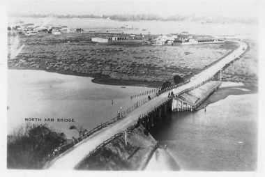 Lakes Entrance Historical Society
Photograph - Aerial view of North Arm Bridge, 1930c
... Aerial view of North Arm Bridge... Aerial view of North Arm Bridge ...Black and white photograph concrete bridge over North Arm, two people at southern end of bridge, swampy area approaching Club Hotel. Lakes Entrance Victoriabridges, township -
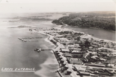
 Lakes Entrance Historical Society
Postcard - Aerial view of Lakes Entrance, 1940c
... Aerial view of Lakes Entrance... Aerial view of Lakes Entrance ...Also 1 Black and White Photographic copy 12.5cmx17.5cm, fair condition P01154-2Black and White Photographic miniature postcard showing the southern abutment of the North Arm Bridge, town, including Club Hotel and garage, sand, hummocks and in distance, the footbridge across Cunninghame Arm. Workmens huts at bridge approach, motor car and truck parked westside of bridge approach. Boats in western boat harbour. Atlantic Ethyl sign behind Club Hotel, and tanks on tall tankstands. Lakes Entrance Victoriabridges, coast, hotels, boats and boating, fences, transport -
Moorabbin Air Museum
Drawing (item) - Posters of Winjeel Wackett trainer Boomerang Spitfire Mk 1 Vampire schematic Curtiss Kittyhawk Combat jets of the World Aerial view of Moorabbin airport, Miscellaneous Aircraft Drawings
... World Aerial view of Moorabbin airport... Kittyhawk Combat jets of the World Aerial view of Moorabbin airport ... -
Moorabbin Air Museum
Drawing (item) - Jeanies Teenie Popular mechanics project Combat jets of the World Aerial view of Moorabbin airport CAC P175 anti tank project P141 CA 22 CA23, Miscellaneous Aircraft Drawings
... World Aerial view of Moorabbin airport CAC P175 anti tank... Popular mechanics project Combat jets of the World Aerial view ... -
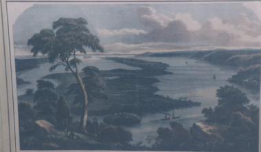
![Painting, untitled [Portland Port], n.d](/media/collectors/4f729f5597f83e03086015b1/items/655a82f77f3f3810362edb30/item-media/655a83847f3f3810362ef766/item-fit-380x285.jpg) Glenelg Shire Council Cultural Collection
Glenelg Shire Council Cultural CollectionPainting, untitled [Portland Port], n.d
Art Collection Previously located in History HouseThe painting depicts the Portland Port from an aerial perspective. The perspective is taken from the ocean looking down across the Port and into the town of Portland. Within the foreground is the ocean beyond the Main Breakwater, the Main Breakwater and the Port. Within the Port nine large ships are docked and another is being brought into the Port by two tugboats. The background features a distant view of the town of Portland and the landscape beyond the township. The work has a white wooden frame and glass.Front: TROMPF (white paint, bottom right corner) Back: (no inscriptions) -
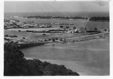
 Lakes Entrance Historical Society
Photograph - Lakes Entrance, 1940c
Also black and white postcard of same view number 03853.1 size 8.5 x 14 cm . c1940Black and white aerial photograph of town looking west from Mechanics Street to Bullock Island with Kalimna escarpment and Rigby Fraser and Flanagan Islands in distance, Avenue of Honour Cypress trees on foreshore Lakes Entrance Victoriaaerial photograph, settlement, caravan parks, camping, ocean -
 Lakes Entrance Historical Society
Photograph - Jemmys Point Lakes Entrance, 1880 c
Colour photograph print of early painting of view from Jemmys Point towards Metung showing paddle steamer and Aboriginals in bottom left hand corner Rigby Fraser and Flannagan Islands centre of painting, The Barrier on the left Nungurner Hills on right Gippsland LakesEntrance to The Gippsland Lakesaerial photograph, township, topography, jemmys point lakes entrance -
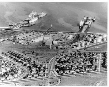 Port Melbourne Historical & Preservation Society
Photograph - Aerial view 1960s of Piers and surrounds
... Aerial view 1960s of Piers and surrounds... the 1960s Photograph Aerial view 1960s of Piers and surrounds ...Gives a good overview of this area of Port Melbourne at a point in time. Identifiable objects are Station and Princes piers; Centenary Bridge; Commonwealth Government Marine Engine works; Beacons; Bank Houses; Commonwealth Oil fuel storage tanks; Missions to Seamen; Trugo club; Railway yards; Beacon Rad, Williamstown RoadPort Melbourne piers and surrounds. Aerial photo from the 1960spiers and wharves, built environment, mission to seamen, beacon -
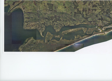 Lakes Entrance Historical Society
Photograph - Aerial view of Gippsland Lakes/Entrance to Tambo River, Gippsland Ports, 2006 c
... Aerial view of Gippsland Lakes/Entrance to Tambo River... Photograph Aerial view of Gippsland Lakes/Entrance to Tambo River ...Colour aerial photograph showing the entrance to Gippsland Lakes from Bass Strait westward to Reeves Channel Shaving Point at Metung through Lake King to Tambo River Gippsland Lakes Victoriaaerial photograph, waterways, township, topography, lakes entrance -
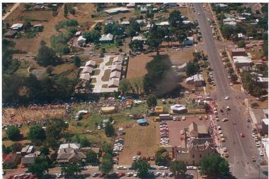 Buninyong & District Historical Society
Photograph - Aerial view of De Soza Park Buninyong taken from helicopter during the Gold King Festival in February 1991, Colour photograph taken from helicopter of De Soza Park
... Aerial view of De Soza Park Buninyong taken from helicopter... Park Photograph Aerial view of De Soza Park Buninyong taken ...An interesting street scene in Buninyong, showing local buildings, vehicles, and the roundabout.Original condition, good, but slightly faded.buninyong street scene., de soza park., gold king festival 1991. -
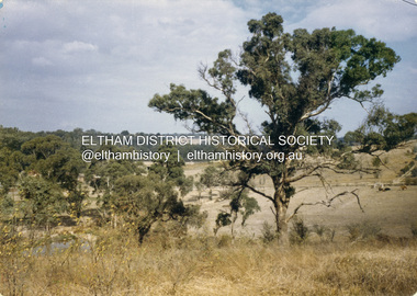 Eltham District Historical Society Inc
Colour Print, David Taylor, View from the rear Eltham High School looking south across Ely Street, Eltham towards the Fabbro family home, c.1976
The view looks across present-day Cronus Court housing development. Aerial photos for 1976 reflect the undeveloped landscape as viewed. By 1981 the estate was well established with all houses built.david taylor collection, eltham, eltham high school, fabbro's farm, cronus court -
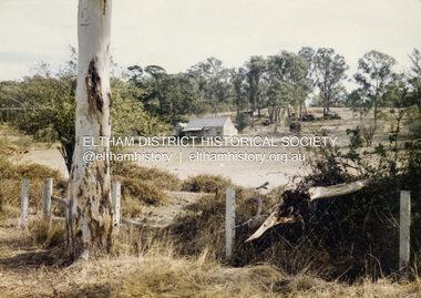 Eltham District Historical Society Inc
Colour Print, David Taylor, Falkiner's Cottage, Ely Street, Eltham, c.1976
Viewed from the western boundary at the rear of Eltham High School looking southwest across part of what would be become the Cronus Court housing development. Aerial photos for 1976 reflect the undeveloped landscape as viewed. By 1981 the estate was well established with all houses built. Falkiner Cottage, also known as Maynard's Cottage. Falkiner was the original owner and Maynard the last owner. The cottage was located on the north side of Ely Street where present day #19 is situated. The cottage ran in a north-south orientation with an easterly aspect down the hill.david taylor collection, eltham, eltham high school, cronus court, ely street, falkiner cottage -
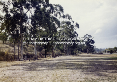 Eltham District Historical Society Inc
Colour Print, David Taylor, Western boundary, Eltham High School, c.1976
View looking north towards intersection of Susan Street and present-day Withers Way, behind the school near the western boundary. To the left of the photo is the housing development of Cronus Court. Aerial photos for 1976 reflect the undeveloped landscape as viewed. By 1981 the estate was well established with all houses built.david taylor collection, eltham, eltham high school, cronus court, susan street, withers way -
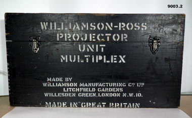 Bendigo Military Museum
Instrument - Multiplex Unit Projector, Williamson Manufacturing Co, Circa 1950
Multiplex mechanical stereoplotting equipment was used at the Army Survey Regiment, Fortuna Bendigo. c1950s. Multiplex equipment was imported from the UK in 1951 and introduced in the following year, to accelerate map production output covering CMF training areas at 1:25,000 map scale. Multiplex plotting was a productive advancement replacing the ‘Arundel’ method of graphical plotting planimetric detail that was expensive and slow, especially in timbered mountainous terrain. Air photos were made into small diapositives and mounted on racks in the exact position relative to when the aerial photos were taken. The technicians operated the Multiplex in a darkened room, with one photo projected with a green filter and the other through a red filter to form a 3D view of the overlapping photos. The 3D model projected onto a platen, which was a small platform that was raised up and down. The technician viewed the 3D image with special glasses fitted with red and green lenses. In the centre of the platen was a small pinhole that served as a floating mark, with a vertical pencil located exactly below the pinhole. This tracing table was moved to follow the topographic feature or contour line and draw it on the paper underneath. The technician raising or lowering the platform’s floating mark to match the height of the 3D terrain. It also replaced the slotted template method of mechanical adjustment of strips of aerial photography, however was restricted to each strip rather than between strips in the block. Although the Multiplex was phased out of production in 1968, it was used in the training of photogrammetry and aero-triangulation at the School of Military Survey located at Bonegilla, Victoria until the early 1990s. The history of the Multiplex is covered in more detail with additional historic photographs, in pages 50 to 51 of Valerie Lovejoy’s book 'Mapmakers of Fortuna – A history of the Army Survey Regiment’ ISBN: 0-646-42120-4. This instrument is only one of the projectors of a set and is unfortunately missing its platen, coloured filters and coloured glasses.A black wooden box containing a Multiplex Unit Projector (incomplete). The Multiplex has a Lamp Head, Barrel Housing, Body of the Projector and a Platen which is missing. .1 Protective wooden box .2 Multiplex Instrument .3 Multiplex Instrument Parts Diagram .4 A bank of Multiplex projectors in operation WILLIAMSON MANUFACTURING CO, PHOTOGRAPHIC ENGINEERS, SERIAL NUMBER 3437, TYPE MPC, LITCHFIELD GARDENS, LONDON AND READING.royal australian survey corps, rasvy, fortuna, army survey regiment, army svy regt