Showing 1088 items
matching demolition
-
 Port Melbourne Historical & Preservation Society
Letter - Correspondence from the Mission Arts Centre, 1987 - 1988
The Missions to Seamen building, designed by architect Harry Norris and built in 1937, was located on the site proposed 50 years later for development by the Sandridge Development Company. The building fell into disrepair after it was closed by the church in 1972, but enjoyed a brief and energetic period in 1987-90 when it was used as a community arts centre. These documents record the campaign waged to save the building from demolition. It was demolished in October 1995.Material relating to a campaign to save the Missions to Seamen building, 1987-88: correspondence from the Mission Arts Centremission to seamen, arts and entertainment, mission arts centre, national trust of victoria, harry a norris, pat grainger, barry merat, brian couldrey -
Port Melbourne Historical & Preservation Society
Flyer - Promotional material from Mission Arts Centre, 1987 - 1988
The Missions to Seamen building, designed by architect Harry Norris and built in 1937, was located on the site proposed 50 years later for development by the Sandridge Development Company. The building fell into disrepair after it was closed by the church in 1972, but enjoyed a brief and energetic period in 1987-90 when it was used as a community arts centre. These documents record the campaign waged to save the building from demolition. It was demolished in October 1995.Material relating to a campaign to save the Missions to Seamen building, 1987-88: flyers, campaign and promotional material from the Mission Arts Centremission to seamen, arts and entertainment, mission arts centre, national trust of victoria, harry a norris, pat grainger, barry merat, brian couldrey -
Port Melbourne Historical & Preservation Society
Flyer - Promotional material from Mission Arts Centre, 1988
The Missions to Seamen building, designed by architect Harry Norris and built in 1937, was located on the site proposed 50 years later for development by the Sandridge Development Company. The building fell into disrepair after it was closed by the church in 1972, but enjoyed a brief and energetic period in 1987-90 when it was used as a community arts centre. These documents record the campaign waged to save the building from demolition. It was demolished in October 1995.Material relating to a campaign to save the Missions to Seamen building, 1987-88: items relating to an open day at the Missions to Seamen building for Heritage Week, 22 to 25 April 1988, including notes for accompanying guided tourmission to seamen, arts and entertainment, mission arts centre, national trust of victoria, harry a norris, pat grainger, barry merat, brian couldrey, town planning, heritage -
Port Melbourne Historical & Preservation Society
Document - Papers, Correspondence and flyers, campaign to save Missions to Seamen building, 1987 - 1988
The Missions to Seamen building, designed by architect Harry Norris and built in 1937, was located on the site proposed 50 years later for development by the Sandridge Development Company. The building fell into disrepair after it was closed by the church in 1972, but enjoyed a brief and energetic period in 1987-90 when it was used as a community arts centre. These documents record the campaign waged to save the building from demolition. It was demolished in October 1995.Miscellaneous correspondence and flyers relating to a campaign to save the Missions to Seamen building, 1987-88: mission to seamen, arts and entertainment, mission arts centre, national trust of victoria, harry a norris, pat grainger, barry merat, brian couldrey -
 Ringwood and District Historical Society
Photograph, Last remaining house on Eastland Shopping Centre site in Ringwood - 1985, 1985
Photos (3) of the former McKinley home (Mayor 1927/28) and later Rymers' at 22 Adelaide Street, Ringwood, Victoria, 1985, prior to demolition for expansion of Eastland Shopping Centre. Covering letter from Connie White, 2014. 1. Ringwood house (Myer car park) 1985 shot 2. Ringwood - old house, Myer car park 3. Ringwood old house - Myer car park -
Federation University Historical Collection
Photograph - Photograph - Black and White, N.L. Harvey & Sons Photographers, Ballarat School of Mines Aerial View
The Ballarat School of Mines Campus is a campus of Federation University Australia.Aerial view of the Ballarat School of Mines campus from the Grant Stret/Eyre Street corner. The photograph was taken after the demolition of the gaol and before the E.J. Tippett Library and Hillman Recreation Reserve were built. The Ballarat Girls' Technical School is present in Grant Street, and in sthe Ballarat SChool of Mines Mining Laboratory in Albert Street. The Ballarat Brewery (then Carton and United Breweries) is present in Lydiard Street South.aerial, ballarat school of mines, ballarat gaol, ballarat school of mines tennis court, grant street, ballarat girls' junior technical school -
Port Melbourne Historical & Preservation Society
Photograph - Various Port Melbourne locations, Jun 1985
Part of Ron LAING's collection of photographs recording Port Melbourne over a thirteen year period. Donated to the PMH&PS by the photographer.Ron LAING photographs .01 - photo taken from a vessel at Station Pier, June 1985. Showing the Port Melbourne foreshore before the old yacht club fire and the building of the high rises. .02 & .03 - photos taken on the corner of Albert and Poolman Streets comparing the scene ten years apart .04 - photo of the Port Melbourne foreshore after demolition of Centenary Bridge, but before the coming of the high rises.built environment - civic, natural environment - beaches and foreshore, piers and wharves - station pier, port melbourne yacht club, pmyc -
 Whitehorse Historical Society Inc.
Photograph, St. John's Catholic Church, Mitcham, c1872c1888
Black and white photo of St. John's Catholic Church, Mitcham erected in 1872. Two wings at rear give the church a cruciform shape were added in 1888. This building became decrepit gradually and prior to its demolition in the 1950's, the end walls of the crossings were supported with heavy 'flying shores'. The church was temporarily replaced with a half-round nissan hut type building, in turn replaced by the present church.st. john's catholic church, mitcham -
 Ballarat Tramway Museum
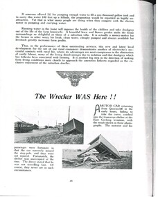
Document - Photocopy, M. Sayers, "The Wrecker WAS Here!!", 2000?
Photocopy of an article in the State Electricity Commission of Victoria Magazine, Contact, Vol 2, No. 1, May. 1937 titled "The Wrecker WAS Here!!". One A4 sheet. The article concerns the demolition of the Geelong East tram terminus by a motorist, travelling from Queenscliff. Two photos are in the item, one of which includes a Birney tram. Record revised 3/4/2019 to add digital images with those from Andrew Cook CD. trams, tramways, sec, geelong, east, shelters -
 Bendigo Historical Society Inc.
Photograph - BENDIGO ARCADE, c1950
Black and white photograph. Demolition site, taken from Old Bennett's Arcade. Brick walls each side, wheelbarrows and machinery on site. Opposite 2 & 3 storey buildings with shops and offices. In image F & E Stillwell, Furniture Warehouse. On windows 'Pitson Bros', GH? Pitson, GJ? Pitson, Public Accountants, Estate Agents, Travel Agents, Sister McKenzie, Chiropodist. Identified by James Lerk as a Alan Doney photo.Alan Doney Photoplace, arcade, bendigo arcade -
Port Melbourne Historical & Preservation Society
Book - Town of Port Melbourne Valuation, 1901
Valuation book, Town of Port Melbourne 1901-02 Purple-black cloth cover, maroon binding and cover gold-stamped. 69 spreads completed, listing name and occupation of tenant and owner of each property, description, number of rooms, size of property, rental etc. Letter from valuer detailing demolition etc pasted p 69; 2 pieces correspondence to Council pasted p. 68 (also Rates; assessments)Figures in ink, back end paper.local government, built environment, joseph turner -
 Eltham District Historical Society Inc
Photograph, Jim Connor, Main Road, Eltham, 14 Jan 2017
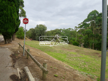
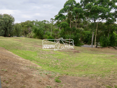
Eltham Gateway, Site of the former Eltham Shire Council offices at 895 Main Road, Eltham Demolished by State Government appoointed Commisoners in August 1996, the site was the original location of Shillinglaw Cottage which was acquired by Eltham Shire in 1963. The Council offices were builty in 1964. A community driven fundraising campain led to the rescu of Shillinglaw Cottage from demolition and it was relocated with Council assistance to its present location a few hundred metres away.Tomorrow's history documented todayeltham, jim connor collection, main road, eltham gateway, 895 main road, shillinglaw trees -
 Eltham District Historical Society Inc
Photograph, Jim Connor, Main Road, Eltham, 14 Jan 2017
Eltham Gateway, Site of the former Eltham Shire Council offices at 895 Main Road, Eltham Demolished by State Government appoointed Commisoners in August 1996, the site was the original location of Shillinglaw Cottage which was acquired by Eltham Shire in 1963. The Council offices were builty in 1964. A community driven fundraising campain led to the rescu of Shillinglaw Cottage from demolition and it was relocated with Council assistance to its present location a few hundred metres away.Tomorrow's history documented todayeltham, jim connor collection, main road, eltham gateway, 895 main road, shillinglaw trees -
![Photograph, Ann [Dowling] Myers, c.1918](/media/collectors/5b29fbbc21ea6714f814b353/items/628a005d1b6dacfccb86f356/item-media/628a01041b6dacfccb86fc3e/item-fit-380x285.jpg) Melton City Libraries
Melton City LibrariesPhotograph, Ann [Dowling] Myers, c.1918
Western Highway – north side Burnbank 1 – Cottage of Henri and Ann nee Dowling Myers side of road east of Myers Gully the junction of Reserve Rd. now known as Ryans Creek. Built c 1870. it remained in the family until a demolition order was placed on it in 1969 when vacated by Martha wife of Frederick 4th son of Ann and Henry. Her new house was built in McKenzie St on the south side near the corner of Smith St. Portrait photo of Annlocal identities, pioneer families -
Port Melbourne Historical & Preservation Society
Book - Town of Port Melbourne Valuation, 1900
Valuation book, Town of Port Melbourne 1900-01. Dark green cloth cover with maroon spine and label gold-stamped. 70 spreads completed, listing name and occupation of tenant and owner of each property, description, number of rooms, size of property, rental etc. Letter from valuer detailing demolition etc pasted p 70. Pages 73-77 removed but 72/74 and 76/77 placed in book. (also Rates; assessments)Markings in pencil. Cross streets added in red pen. Notes on lined paper pasted front end paper.local government, built environment, joseph turner -
 Buninyong & District Historical Society
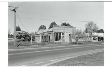
Photograph - Original B/W Photograph, Former Whyke's Grocer building, Warrenheip St, Buninyong, 18 September 1993
Original building was established by Whyke's family Grocery, built in 1860s. Stripped to apricot brickwork. Verandah removed. Situated East Side of Warrenheip St between Eyre St and Forest St, Buninyong. Building much altered and used as a restaurant in 1970s. Fell into disrepair. Revival took place but not restoration. 1990s under threat of demolition if not conforming to council safety requirements. Building has since been renovated as a pizza restaurant (2023). Vacant lots have since been built on.Established by a prominent local family, an example of a mid 19th century shop. Black and white photo of former Whykes Grocer, 1860's. Streetscape photo of former Whykes Grocer brick building. Power pole with Warrenheip St sign. 3 other shopfronts visible, street trees and vacant land between shops.buninyong, whykes, grocery, building, street scape, warrenheip st -
 Bendigo Historical Society Inc.
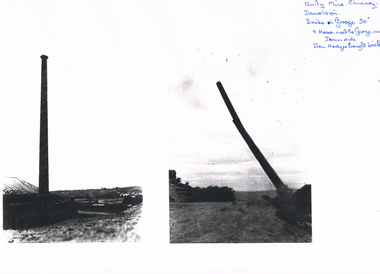
Photograph - LONG GULLY HISTORY GROUP COLLECTION: DEMOLITION OF UNITY MINE CHIMNEY
Two black and white photocopies of the Unity Mine Chimney. The one on the right shows the tapered chimney standing. It has a paler spiral pattern coming down the height of the chimney and a wider piece at the very top. The photo on the right shows the chimney falling. The top piece has gone and it has a bend and crack near the top. Written in the top right corner is: Unity Mine Chimney. Demolition. Bricks in Garage? 30' & House next to George on Downside. Ben Hodges bought bricks.bendigo, history, long gully history group, the long gully history group - demolition of unity mine chimney, ben hodges -
 Whitehorse Historical Society Inc.
Photograph, Britannia Street, Mitcham, 13/06/1986 12:00:00 AM
2 Coloured photos of Brittania Street, Mitcham. Looking North from Corner of Whitehorse Road. Shops on Western side of Britannia Street are located on the site of Barelli's shop, dwelling and bakehouse. To the north of these buildings and across a cobblestone lane now called Enterprise Way was the Salvation Army Citadel, .a further commercial building housing a printer. Erection of this building necessitated demolition of Barelli's stable and reclamation of its horseyard. The Salvation Army are now located on the Mitcham Road and Harrison Street corner.britannia street mitcham -
Kew Historical Society Inc
Archive (Sub-series) - Subject File, Kew Court House 1986-1989, 1986
Various partiesReference, Research, InformationSecondary Values (KHS Imposed Order)Subject file containing information relating to the Kew Post Office complex, including the Kew Court House and the Police Station. The correspondence between parties included the City of Kew, the Kew Historical Society, and the Victorian Government. Initially the correspondence related to the proposed use of the Court House as a Centre for the Society as it was being forced to vacate the Copy Shop (q.v) in Walpole Street due to its impending demolition. Later correspondence relates to the proposed sale of the Court House by the Victorian Government.kew - history, kew court house, kew police station, heritage campaigns - kew (vic)kew - history, kew court house, kew police station, heritage campaigns - kew (vic) -
Glen Eira Historical Society
Article - Elizabeth Street, 30, Elsternwick, formerly Trengrove
A one page article from the Southern Cross newspaper, dated 09/12/1998, on page 12, for the auction of the mansion at 30 Elizabeth Street. The article includes a brief history of the existence of a 1908 property called "Trengrove", occupancy of the current house built for Mrs SJ Hannon after the demolition of "Trengrove" in 1937, mention of the Edna Walling-designed garden, a description of the property and the interior plan and three colour photographs (168mm x 121mm; 59mm x 78mm; 58mm x 73mm) taken by Maurice Grant-Drew.rippon lea estate, elizabeth street, elsternwick, sargood fredericl sir, bent thomas, hannon s j mrs, georgian revival style, gardens, architectural features, walling edna, flats, house names, talbot birner morley, trengrove, architectural styles, grant-drew maurice -
 Eltham District Historical Society Inc
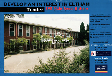
Document, Tender Documents for purchase of Former Eltham Shire Offices 895 Main Road, Eltham, April 1996, 1996
Graeme Hardiman Real Estate Prepared for Nillumbik Shire Council Maddock Lonie & Chisholm, 140 William Street, Melbourne Tenders closed at 3.00pm on 24 April 1996 Whilst the sale of the former Shire Office site went through and the Shire Commissioners approved the demolition of the building several months later in the year, ongoing community protests and objections eventually led to the reversal of the sale. Despite several further attempts to sell the site and community protests as recent as 2019, the vacant land remains in Council ownership.89 A4 pages; 1 x glossy paper with photo and 88 x photocopied pageseltham shire office, graeme hardiman first national real estate, maddock lonie & chisholm, nillumbik shire council, real estate, tenders -
 Orbost & District Historical Society
program, F.W. Niven & Co, 1893
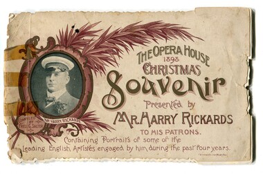
Harry Rickards was an English singer and comedian who managed and the bought the Opera House in Bourke Street, Melbourne. At the turn of the century, safety concerns forced the closure and eventual demolition of the Opera House. Rickards died in London on 13 October 1911, and the New Opera House, as well as the Tivoli business, was sold to boxing entrepreneur Hugh D. McIntosh. In 1914, in line with the other venues on the national circuit, the New Opera House was renamed the Tivoli. This program would have been retained as a souvenir of a visit to the Opera House.This item is a souvenir retained as a memento of a theatre event in the late 19th century.A souvenir booklet with a coloured drawing of a man, Harry Rickards, wearing a captain's hat on the left side. Rhis is inside an oval frame decorated with feathers. It is a "Christmas Souvenir of the Opera House 1893".rickards-harry salter-fred-g program-theatre souvenir -
Stawell Historical Society Inc
Map - Drawings, Wendy Jacobs, Western Highway, 2014
WD 1/13 - Site Plan WD 2/13 - Existing Conditions & Demolition Plan WD 3/13 - Floor Plan WD 4/13 - Elevations WD 5/13 - Sections AA & BB WD 6/13 - Sections CC WD 7/13 - Sections DD, EE & FF WD 9/13 - Roof Plan WD 10 /13 Reflected Ceiling Plan WD 12/13 - Toilet & Meeting Cup'd Details WD 13/13 - DetailsEleven (11) A1 Printed MapsWendy Jacobs Architect & Heritage Consultant Nov 2014 -
 Williamstown Botanic Gardens- Hobsons Bay City Council
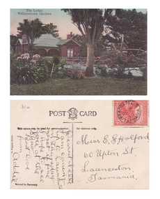
Postcard – Williamstown Botanic Gardens, M Schulz, Prague, c1900-1920
The original postcards in this series (2013.002 to 2013.018) were generously loaned to Williamstown Botanic Gardens by a private collector for copying. The logo in the middle of the words ‘POST CARD’ indicates the card was printed by M. Schulz in Prague. Schulz was a long-established company from Prague and printed postcards for customers from worldwide. Schulz printed in photo-chromolithography. The Curator’s lodge, designed by the Town Surveyor, HV Champion, was constructed in 1907 following the re-organisation of the north-east corner with the demolition of the old curator's cottage and erection of new gates. The postcards are evidence of the interest the gardens held as a subject for postcard publishers. The text and images provide a snapshot into fashions, social interests and concerns of the time. The professionally produced images provide a pictorial history of Gardens including changing planting styles, various structures and features of the Gardens eg the aviary, cannons, the fountain, the second Curator’s Lodge and gates. The images offer an opportunity to compare garden vistas with the present day. The card also demonstrates how postcards were used as a method of contact in contrast to the contemporary use as souvenirs. A colour image of a house (the Curators lodge) behind a fence with two children sitting on it. There are two large Cordylines, one in the forefront of the image standing in lawn and surrounded by pink flowers, and one closer to the house. The house is brown timber with two brick chimneys and has a green corrugated iron roof with gables over the windows at the front and side.Front: ‘The Lodge, / Williamstown Gardens’. Reverse: Centre top ‘POST CARD’ with a logo [MS] in the middle of the words; left side vertical ‘O. Rippon Series’; left side ‘This space may be used for communication.’; right side ‘For Address only.’; left side bottom ‘Printed in Germany’. There is a one penny red Tasmanian stamp on the top right hand corner. The card is addressed to ‘Miss E G Holford / 60 Upton St, / Launceston, / Tasmania.’ Top left corner in pencil ‘$10’ (believed to be inserted by the vendor.postcard, gardens, post-card, williamstown-botanic-gardens, hobsons-bay-city-council, curator’s lodge, children, cordyline -
 Melbourne Tram Museum
Newspaper - Photocopy, The Age Newspaper, Roper rejects proposal to protect historic tram engine room, 28-11-1989
Provides a report from The Age, 28-11-1989 written by Ingrid Swendsen, about the rejection by the Planning and Environment Minister , Tom Roper to protect the former cable tram winding or Engine house on the corner of Bridge and Punt Roads Richmond, despite the recommendation of the Historic Buildings Council to add it to the register. The building was later demolished by the Roads Corporation to widen the intersection. The Tramways have a small sub-station on the site. Quotes Douglas Hill of the National Trust and Roz Hansen of the Historic Buildings Council. Provides a report on the rejection of a recommendation to protect a historic building.Photocopy of a newspaper clipping from The Age 28-11-1989 - Roper rejects proposal to protect historic tram engine roomtrams, tramways, cable trams, engine house, winding house, punt road, bridge road, demolition, richmond, historic buildings council -
 Bendigo Military Museum
Document - INSTRUCTIONS, EXPLOSIVE TRAINING, Aust Army, c1953 - 1972
1. A4 pages held together with one staple - Assault Pioneers Demolitions Part 1, 1953. 8 pages. 2. A4 size page - held together with one staple - Assault Pioneers 1953 - 2 pages. 3. A4 size page single. Preparation of M18A1 Claymore mine for firing. 4. Foolscap page - Safety regulations for M2A1-7 Flame thrower. 5. Foolscap page - single sheet. Assault Pioneers, Mine Warfare and Booby Traps, General Rules.training, army, notes -
City of Kingston
Photograph - Colour, 29 January 1993
Bonbeach, Carrum and Patterson Lakes are suburbs in the City of Kingston. Bonbeach and Carrum were holiday destinations in early 20th century and over time the housing has converted to permanent residential structures. In Patterson Lakes, the area consists predominantly of newer housing developments and the tidal canal system which is accessible to many dwellings joins Port Phillip Bay.Bonbeach, Carrum and Patterson Lakes were previously part of the extensive Carrum Carrum Swamp. The area was once a source of fish and eels for the Mayone-Bulluk clan of the Bunurong people. Over time the area was drained and this allowed farming at Carrum and Bonbeach, although the area was prone to flooding. In the early 1920s and 30s the land was converted to residential dwellings. In 1973 investigations commenced nearby to Bonbeach and Carrum into the development of a unique residential area comprising canals and waterways. It was originally proposed to be known as "Gladesville". Circa 1974, the area was rezoned from rural to residential and named Patterson Lakes. Development has been continuous since the 1970s with staged construction of the waterways, residential housing, and supporting infrastructure and facilities.Laminated colour aerial photograph of the Bonbeach, Carrum and Patterson Lakes region within City of Kingston. This 1993 image includes Bonbeach High School prior to demolition, Bonbeach Primary School and Patterson River Golf Club. Sections of Patterson Lakes are not yet developed, including Rhode and Staten Islands. Long Island Point appears to be a recent development with many spare blocks and new houses under construction. The Patterson River marina is prominent and the river mouth as it meets Port Phillip Bay. The Carrum railway station is visible.Black type on white adhesive sticker: No. 6661 Black type on white adhesive sticker: 26E/6661, 29/1/93, 4.25 pm Black type on white adhesive sticker 29-1-93 Yellow circular adhesive stickerbonbeach, carrum, patterson lakes, patterson river, carrum carrum swamp, canals and waterways -
 Eltham District Historical Society Inc
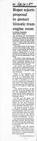
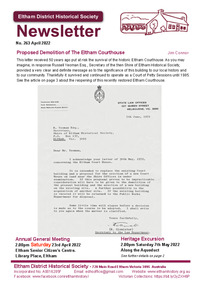
Journal - Newsletter, Newsletter, No. 263 April 2022, Apr 2022
Contents: • Proposed Demolition of the Eltham Courthouse by Jim Connor • Heritage Excursion – Along the Aqueduct – Saturday 7th May 2022 • Municipal District – Eltham (Victoria Gazette No. 140 – March 26, 1957 • Eltham Courthouse Officially Reopened by Jim Connor • Murray’s Bridge by Jim Connor • Shire of Eltham • A 21st Celebration? By Jim Connor • Eltham Cemetery Stories by Liz Pidgeon o Elizabeth Agatha (Betty) Erickson, nee Carrucan 1915-1990 • Our History – Our Library • Annual General Meeting – 2.00pm, Saturday 23rd April 2022The Shire of Eltham Historical Society was formed in October 1967. The first newsletter of the Society was issued May 1978 and has been published continuously ever since on a bi-monthly basis. With the cessation of the Shire of Eltham in late 1994, the Society's name was revised to Eltham District Historical Society and this name first appeared with issue No. 103, July 1995. The collection of the Society's newsletters provides a valuable resource on the history of the Society's activities, office bearers and committee members, guest speakers and subjects of historical interest pertinent to the former Shire of Eltham and the Eltham District.A4 newsletter distributed to members (Digital and A4 photocopy)newsletter, eltham district historical society -
 Eltham District Historical Society Inc
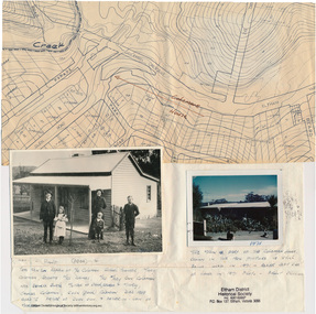
Folder, Colemans Corner, Eltham
Letter from Nillumbik Council to H.Gilham in response to consultation on Wattletree Road Bridge replacement, 13 August 2007, 1p. VicRoads brochure on Wattletree Road bridge replacement project, August 2007, 1p Photo of "Coleman's house", 1904 with brief family history. (Photo retrieved by Harry Gilham from from a 1972 'time capsule bucket' found at the Eltham Shire Office during its demolition in July-August 1996 (See also SEPP_0745 and 1678A) Photo of "Coleman's house", 1971 Survey plan showing location of Coleman's houseFolder of information and photos relating to the Colemans Corner precinct located on the corner of Main Road and Wattletree Road, Eltham. HG Booklet 9bus services, wattletree road bridge, coleman family, coleman's corner, harry gilham collection -
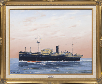 Queenscliffe Maritime Museum
Painting - Beltana, Dacre Smyth, SS Beltana
Beltana was launched in 1921 at a cost of £179,000. She was a passenger liner built specifically for the UK-Australia emigrant service via the Cape of Good Hope. In October 1917, she was requisitioned for Transatlantic service where she carried munitions and supplies, returning to emigrant service in 1919. On 31 March 1930 she was sold for £27,000 to Toyo Hogei Kabushiki Kaisha, Japan for conversion for the whaling trade. She was not renamed, being laid up in Japan. She never traded under the Japanese flag. In 1933 she was sold to Gentaro Kasegawa, Kobe for demolition. Mrs B SmythFramed oil painting of the ship BeltanaBeltanass beltana, transatlantic supply transport, wwi, migrant ship