Showing 1942 items matching " flooding"
-
 8th/13th Victorian Mounted Rifles Regimental Collection
Photograph - Born digital image
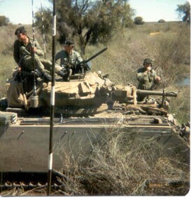
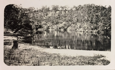
A region on the Lachlan River flood plain north of Booligal New South Wales with its lightly timbered grassland criss-crossed with numerous flowing channels and water filled billabongs provided a challenging training area for a unit equipped with M113 family of vehicles. A Squadron 8/13 VMR deployed there in September 1985 for its annual exercise. The MRV was from 3 Troop commanded by Corporal RAC (Bob) MacDonald of Wangaratta Victoria. Army Reserve training in challenging countryColour image of M113 Medium Reconnaissance Vehicle(MRV) of A Squadron 8/13 Victorian Mounted rifles on annual exercise in Booligal region NSW, 1985.booligal, annual exercise, 8/13 victorian mounted rifles -
 Warrnambool and District Historical Society Inc.
Document - Calendar 2021, 2020
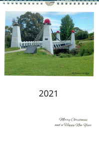
This calendar has local Warrnambool scenes taken during 2020, featuring a different image each month. Included are Wollaston Bridge, January 2020 Gippsland bushfire smoke in Warrnambool streets, Hopkins River, Proudfoots Boathouse, Merri River School, Deakin University, Hopkins River boat ramp, Warrnambool breakwater, Middle Island Warrnambool, Hopkins Falls, Merri River flood at Wollaston Bridge, Warrnambool War Memorial, private houseA4 size calendar, with wire binding, white background with coloured image of Wollaston Bridge and text in black.2021, Merry Christmas and a Happy New Yearbushfires, warrnambool, hopkins river, proudfoots boathouse, schools, education, deakin university, bridges, wollaston bridge, war memorials, harbours -
![The Punt, Echuca / [by] Nicholas Caire, circa 1876](/media/collectors/550653872162f11fb04854aa/items/57825721d0cdd1176ce1789a/item-media/57825765d0cdd1176ce19829/item-fit-380x285.jpg) Kew Historical Society Inc
Kew Historical Society IncPhotograph, Anglo-Australasian Photographic Company, The Punt, Echuca, c. 1876
Nicholas Caire was born on Guernsey in the Channel Islands in 1837. He arrived in Adelaide with his parents in about 1860. In 1867, following photographic journeys in Gippsland, he opened a studio in Adelaide. From 1870 to 1876 he lived and worked in Talbot in Central Victoria. In 1876 he purchased T. F. Chuck's studios in the Royal Arcade Melbourne. In 1885, following the introduction of dry plate photography, he began a series of landscape series, which were commercially successful. As a photographer, he travelled extensively through Victoria, photographing places few of his contemporaries had previously seen. He died in 1918. Reference: Jack Cato, 'Caire, Nicholas John (1837–1918)', Australian Dictionary of Biography.An original, rare photograph from the series 'Views of Victoria: General Series' by the photographer, Nicholas Caire (1837-1918). The series of 60 photographs that comprise the series was issued c. 1876 and reinforced a neo-Romantic view of the Australian landscape to which a growing nationalist movement would respond. Nicholas Caire was active as a photographer in Australia from 1858 until his death in 1918. His vision of the Australian bush and pioneer life had a counterpart in the works of Henry Lawson and other nationalist poets, authors and painters.Views of Victoria (General Series) No.34; ‘The Punt, Echuca’; Albumen silver photograph | Photo on card with Title and Description on reverse | Mounted 24 x 30 cm; Photo 12 x 17 cm.On Reverse: ‘The subject of this illustration is the principal crossing-place on the River Murray at Echuca, as regards the ordinary road traffic from the district of Riverina, New South Wales. After the periodical floods, the Punt is found to be insufficient for the large traffic; but this inconvenience will not be found to occur again to any great extent, as the new Railway Bridge from Moama will considerably lessen the road traffic through the Township of Echuca.’nicholas caire (1837-1918), echuca (vic), landscape photography -
 Eltham District Historical Society Inc
Album - Photograph, J.A. McDonald, Eltham-Greensborough Road, 18 Oct. 1956
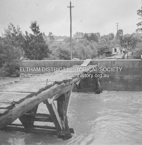
Bridge Street Bridge Flood level on Greensborough pier 18th October 1956 View looking west across the Diamond Creek and tempoary walking access bridge towards intersection of Susan Street. The building visible on centreeline is the present-day SES facility. Beware!.. our rivers are rising (1956, October 19). The Argus (Melbourne, Vic. : 1848 - 1957), p. 1. Retrieved August 24, 2022, from http://nla.gov.au/nla.news-article84392304Record of various Shire of Eltham infrastructure works undertaken during the period of 1952-1962 involving bridge and road reconstruction projects, sometimes with Eltham Shire Council Project Reference numbers quoted. It was during this period that a number of significant improvements were made to roads and new bridges constructed within the shire that remain in place as of present day (2022). In many situations, the photos provide a tangible visible record of infrastructure that existed throughout the early days of the Shire. The album was put together by or under the direction of the Shire Engineer, J.A. McDonald.infrastructure, road construction, shire of eltham, bridge construction, bridge street bridge, eltham, eltham-greensborough road, 1956-10-18, diamond creek (creek), floods, floodwater, silver street bridge -
 City of Moorabbin Historical Society (Operating the Box Cottage Museum)
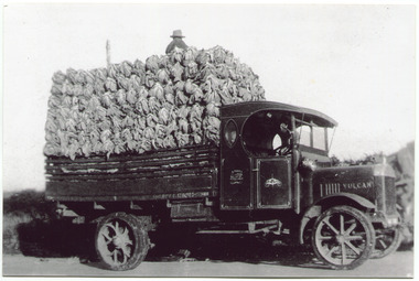
Photograph, Black & White, V Peterson, loaded Vulcan Truck 1929, c1929
The Peterson family were early settlers in Moorabbin Shire and established a market garden in East Boundary Road East Bentleigh. Horse drawn wagons traveled along Plateways to take their crops to the Melbourne Markets . With the advent of the motorcar the market gardeners gradually purchased trucks to transport their crops. Roads were being surfaced but ruts and flooding caused upsets and bogging of these trucks. The journey was quicker but unlike the Horses, these trucks could not drive themselves back to the farm.The early settlers like the Petersons and Marriotts, in the Parish of Moorabbin County of Bourke after Henry Dendy's Special Survey Brighton 1841, established market gardens, fruit & flower gardens, poultry & dairy farms, vineyards as well as shop businesses, blacksmiths, chemists, nursing homes and schools & Churches.Black & White photograph of a Vulcan truck driven by Vic Peterson, loaded with Cauliflowers from his market garden in East boundary Road East Bentleigh c 1929.Back Handwritten information unsgnedwagons, vulcan trucks, draught horses,, peterson vic, marriott dick, cauliflower crops, vegetable crops, poliomyelitis epidemics 20thc , elster creek, plateways moorabbin shire, smith j l; smith mary ann, stanley helen, smith vic chaff cutter, horse drawn carts, toll gates brighton, motor cars 1900, steam engines, early settlers, bentleigh, mckinnon, parish of moorabbin, city of moorabbin, county of bourke, moorabbin roads board, shire of moorabbin, henry dendy's special survey 1841, were j.b.; bent thomas, o'shannassy john, king richard, charman stephen, highett william, ormond francis, maynard dennis, market gardeners, vineyards, orchards -
 Bendigo Historical Society Inc.
Document - DRAINAGE PROBLEMS - MINERS SENSATIONAL EXPERIENCE AT THE VICTORIA QUARTZ
Handwritten notes from a Bendigo Advertiser report, Thursday June 16th 1910. Management had for some time been apprehensive that the flooding in the deep mines to the south would affect them. Lansell's 180 took the precaution of baling. On the Tuesday night the men at the Victoria Quartz had a sensational experience. The storage dam at 3324 ft level receives the overflow from the flooded mines to the south. The level connects with the 3310 level at the Big 180. The water flows uninterrupted into thestorage dam which has a capacity of about 270 tanks. The dam had been emptied on Tuesday morning and work continued until 10 pm that night. The platman noticed that the water was coming down the shaft in a regular torrent. They didn't take much notice as they thought it was a leakinig outlet valve on the ascending tank. At 11 pm the releiving shift came down the shaft and said that the dam at 3,324 ft must be overflowing. The velocity of the water pouring down the shaft increased and the men made a hurried exit from the bottom of the shaft which is down 310 ft from the 4.254 ft plat (a total depth of 4,564 ft). An inspection of the dam at the 3324 ft level found it to be overflowing. By morning (Wednesday) the shaft had filled, and the water rose to 7 ft in the plat at 4254 feet. Mining inspector hgave orders that men were not to go below the 3324 ft level. Baling continued without cessation at the Big 180 all day and could not lower the water. Drilling machines etc and a powerful air winch at the 4254 ft plat are under water. An inspection made of the 3100 ft level at the 180 mine where the workings are connected with the New Chum & Victoria showed that water was running strongly from that mine proving that the inrush was due to flooded water from the southern deep mines to the south. Document from Albert Richardson Collection of mining history. Document from Albert Richardson Collection of mining history.document, gold, drainage problems, new chum drainage scheme, miners sensational experience at the victoria quartz, bendigo advertiser 16/6/1910 page7, lansell's 180, big 180, new chum & victoria -
 Bendigo Historical Society Inc.
Postcard - GLADYS DEAN COLLECTION: POSTCARD, 1906 - 1908
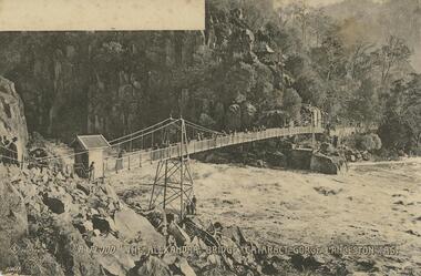
Printed black and white photographic postcard. Image is of a rocky gorge with a suspension bridge across the river below. A small wooden gatehouse is at one end and people are walking or standing at various points across the bridge and on the path in the distance. A white blank space is in the upper left hand corner of the image. A symbol of a diamond shape with the letters S C entwined, followed by the words No 76 Photoprint A Flood The Alexandra bridge. Cataract Gorge Launceston Tas are printed in white across the bottom edge. The numbers A10659 in white are printed in the lower left hand corner. The reverse is blank.Diamond shape with SC entwined No 76 Photoprint A 10659 The 'Wynphotoprint' Series published by Selwyn Cox Launceston Taspostcard -
 Bendigo Historical Society Inc.
Newspaper - JENNY FOLEY COLLECTION: UP AND AWAY
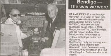
Bendigo Advertiser "The way we were" from Wednesday, May 12, 2004. Up and away: former Bendigo mayor Cr T.R. Flood, on right, gets ready to take off with an unnamed Qantas pilot of the first Boeing 707/338C, with a convertible passenger-cargo cabin, in 1967. The jet, named The City of Bendigo, took the mayor, and six other Bendigonians, from Avalon to Sydney, including a cruise over Melbourne. The Bendigo party were also guests of Qantas at the then modern Wentworth Hotel. Before returning to Victoria, they were taken on a tour of the Kingsford Smith aerodrome at Mascot.newspaper, bendigo advertiser, the way we were -
 Kew Historical Society Inc
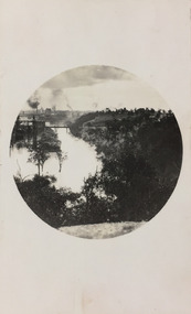
Photograph - Yarra River, Studley Park, 1924
Henry Beater Christian (1886-1962) , was a descendant of one of the earliest settler families in Kew. Employed at the Kew Asylum as a 'public servant', he was a skilled amateur photographer, photographing numerous scenes in Kew and on his travels around Victoria. The majority of his photographs date from 1916 to 1929. His finest photographs are housed in two photograph albums. Digital copy of a photograph from page 7 of the 47-page photograph album containing 261 gelatinous silver images, loaned by Diane Washfold with permission given to digitise and hold a copy in our collection. This photograph was taken during a flood year, perhaps 1923, when the Yarra encroached on the grounds of the Abbotsford Convent. In the distance, the Johnston Street Bridge separates the viewer from the industrialised landscape of Fairfield. In developing the photo, Henry Christian employed a circular frame to artistically focus the view. He empkloyed this technique for what he may have viewed as his best photographs. "Studley Park / Kew"henry beater christian (1886-1962), landscape photography, kew (vic.) — yarra river, christian-washfold collection, photograph albums, fairfield, kew, johnston street bridge, studley park -
 Kew Historical Society Inc
Photograph - Zig-Zag Bridge, 1924
Henry Beater Christian (1886-1962) , was a descendant of one of the earliest settler families in Kew. Employed at the Kew Asylum as a 'public servant', he was a skilled amateur photographer, photographing numerous scenes in Kew and on his travels around Victoria. The majority of his photographs date from 1916 to 1929. His finest photographs are housed in two photograph albums. Digital copy of a photograph from page 8 of the 47-page photograph album containing 261 gelatinous silver images, loaned by Diane Washfold with permission given to digitise and hold a copy in our collection. The Zig-Zag Bridge linked the grounds of the Yarra Bend and Kew Asylums. The wooden bridge was constructed in the 1870s and lasted through numerous floods until its destruction in 1929. A horizontal structure, the walkway was reached via a wooden staircase. The steps were requires due to the different levels of the banks on this stretch of the river. The photo is taken from the Kew side of the river. "Zig-Zag Bridge"henry beater christian (1886-1962), landscape photography, kew (vic.) — yarra river, christian-washfold collection, photograph albums, zig-zag bridge -
 Kiewa Valley Historical Society
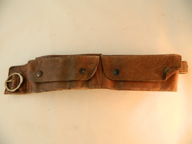
Belt Money, Circa 1950
This money, belt made of soft leather, would have been used in the mid 1900's by horse riding traders or wealthy property owners. It could also have been used by miners or other commercial business men. The main criteria for such a belt is security for valuables during travel on horseback. Commercial traders who plied their wares on horseback or caravans during a period where poor roads and flood prone rivers could dislodge wallets or money "sacks".The Kiewa Valley in the early 1900's was an environment which was frequented by the "canny" travelling salesman using dirt tracks and having to cross swollen rivers and creeks throughout the year. Travelling times within the rural areas in and surrounding the valley called for more frequent stops in bush lands. Camping presented itself with great challenges not to loose small cumbersome coin and notes. Local banks were of short supply and although bartering was a thriving method of transactions within the Valley traders from other regions were not so forth coming. Where ever possible local "trades" were called upon more than in city areas for limited products of a rural incline.This "vintage" handcrafted money belt has been professionally made circa 1950's. It appears as though it might have been made in a saddlery. There are five pockets each fastened by black painted "press studs". The stitching is of a high standard and the pockets are large and well defined. The buckle is circular with one fastening pin.handcrafts, leather work, vintage money belt, personal effects. -
 Orbost & District Historical Society
black and white photograph, 1920s - 1930s
There is no record of which family is in the photograph. The slips at Corringle was a popular picnic area for Orbost people. Corringle Slips is situated at the mouth of the Snowy River Estuary. The Corringle Slips were built by Samuel Richardson and sons during the time when the Orbost Shipping Company was operating. The Slips were washed away in the 1893 floods and reassembled by Martin Jorgensen who then became a part owner of the Slips. In the late 1890's, Corringle was a thriving rural community. (Information from Discovering Marlo brochure)This is a pictorial record of family life in Orbost in the first half of the 20th century. It portrays a typical Orbost family enjoying a leisure activity. The clothing can be seen as more formal than that worn at a family picnic in the present day,A black / white photograph of a group of people (adults and children) seated around a table set with a tablecloth on which are teacups, bottles of drink and cake. in the front is a bucket and two metal boxes. They are well-dressed with the men and boys wearing jackets and ties and some of the women wearing cloche style hats.on back - "Family at Slips"corringle-slips-marlo picnic-recreation -
 Robin Boyd Foundation
Document - Script, Robin Boyd, The Flying Dogtor. Episode 18 The Visitors, 1963
The mysterious spots were caused by mosquito bites, due to the stagnant water from the flood. They had run out of medicines, bandages, everything, with no money to buy more. The Dogtor discovered a gold nugget in his bag from the mines and told nurse Sister Spaniel to take it to the bank to change it for money. Life then returned to normal at Hilltop Hospital. Then one day, a big loud silver helicopter appeared in the sky with a notice: WOOMERA RANGE. V.I.P. TOP SECRET. SPACE SURVEY. ROCKET DIVISION.The Flying Dogtor" series was broadcast on Australian Television Network (later becoming the Seven Network) between February and April 1964 (see item D254 for schedule).Typewritten, carbon copy, foolscap, 2 pagesPage 1: handwritten 'CUT' on left hand side.the flying dogtor, robin boyd, crawford productions, manuscript -
 Stawell Historical Society Inc
Photograph, “Swinton” Homestead in Glenorchy with alight pole and flagpole on the front lawn, 1913 approx
Black and white photo of “Swinton” Homestead Glenorchy with light pole and flagpole on front lawn. Swinton was a family name of John Carfrae whose father was Thomas Swinton Carfrae of Edinburgh. When John Carfrae came to Ledcourt in 1848 he divided it into three runs, Ledcourt - Swinton & Newington. Alexander Grey came to Swinton in 1881. The Grey Family still live at Swinton. After severe floods in 1909 the original homestead was destroyed. This home picture was built in 1911 on a site on higher grounds.B/W. Photograph: of a substantial house with five chimneys and verandah and Flagpole, in the mid distance is a light pole with a gas light, in the foreground is a tree. This photograph is a copy of a negative owned by the society. Paid with a grant 1991. this photograph is of the home at SWINTON Glenorchy. glenorchy -
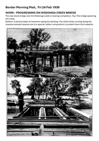 Wodonga & District Historical Society Inc
Photograph - Wodonga Creek Stock Bridge Collection
The Wodonga Creek Stock Bridge was constructed by the Country Roads Board in 1939. The date was recorded on a small plaque attached to one of the trestles. The bridge is an important reminder of one of the industries Wodonga was built on — cattle. It was constructed to develop a new stock route between Albury and Wodonga which would direct cattle away from the main bitumen roads and traffic bridges to the Wodonga Saleyards, where thousands of sheep and cattle were sold each month. It is a moderately tall timber trestle road bridge consisting of nine spans, with a deck length of 76 metres and deck width of 4.5 metres, and a maximum span length of 8.5 metres. The substantial timber deck featured decking laid horizontally and longitudinal running planks laid on top of it. The bridge also has timber side safety rails to discourage livestock from straying over the side. The bridge also became the centre of summer social activity for the young people of Wodonga as the area became a gazetted swimming area before the Wodonga Swimming Pool was constructed in 1959. In 1980 the Wodonga Saleyards were relocated to Bandiana to the east of the city. This meant that Wodonga Creek Stock Bridge was no longer needed for its original purpose. Although listed as a significant site by the Victorian Heritage and National Heritage Trust on 3/08/1998, the bridge fell into disrepair and also suffered damage from several floods. A suspension Bridge was constructed beside the Stock Route Bridge in 2013 and the old bridge was closed to traffic. Major damage caused by several floods, including a major flood in 2022 has resulted in the bridge being unsafe and its future is uncertain. The model of the Wodonga Creek Stock Bridge in our Collection made by Mr John Wild, depicts its current condition.The Wodonga Creek Stock Bridge is significant for technical, historic and social reasons and has been registered at the State Heritage level. It is of technical significance as a nine span bridge with tall timber trestles. Large bridges of this type are now very rare in Victoria. It is of historic significance as a surviving structurally authentic bridge designed specifically for livestock and drover use, on a historic stock route. The Stock Bridge is of social significance for its location at a popular riverside leisure spot since its construction in 1939.A collection of photographic images depicting the Wodonga Creek Stock Bridge. It contains both black and white and coloured images taken at different times in the Stock Bridge's history. A model of the Bridge made for Our Society is also included.wodonga creek stock bridge, wodonga heritage -
 Eltham District Historical Society Inc
Photograph, M. North, Main Road, Eltham near Fitzsimons Lane Roundabout, Dec 1985, 1/12/85
Two colour photographs of Main Road, ElthamSouth between Falkiner Street and Bolton Street at the roundabout of Fitzsimons Lane, Eltham, Dec 1985Noted on 463B 'See 1934 small black and white snap of flooded bridge and the same two shops. This snap taken from same location, Dec 1985. Old Eltham Park on right of photo The two shops at left (Ansel and Muir) Road ahead crosses new bridge over the Diamond Creek, Eltham Main Road now dual highway, through Lower Plenty to this bridge'main road, eltham, eltham south, fitzsimons lane, round about, falkiner street -
 4th/19th Prince of Wales's Light Horse Regiment Unit History Room
Regimental Scrap Book: 1990-1999, 2009
Archival quality A3 loose leaf slip case containing memorabilia documents, cuttings and photos about the Regiment for the period 1990-1999. Contents include:Training, Ceremonial, social activities. Hansard 18 Oct 1990 re future of the Regiment. Threats to the Regiment. Chief of General Staff Commendation to A Squadron 4/19 PWLH for assistance with flood emergency in Gippsland April 1990. Meritorious Unit Commendation to Prince of Wales Light Horse Troop while attached to 173 US Airborne Brigade, South Vietnam 1965/66. Freedom of City of Melbourne May 1992. 50th Birthday of Regiment. Closure of Traralgon Depot 1998.ceremonial, training, vietnam war, history 4 19 prince of wales s light horse, freedom of city melbourne, freedom of city traralgon, traralgon army depot, commendations, gippsland floods -
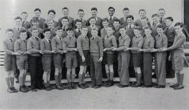 Federation University Historical Collection
Photograph - Image, Ballarat Junior Technical School Choir, 1956, 1956
The Ballarat Junior Technical School Back Row L-R: R.J. King, J. Halliday, B. Antonio, P. Montgomery, W. Wilkins, G. Kiddie, J. Clarke, G. Nicholls, K. Burge, J. Gullock Middle Row L-R: W. Doyle, I. Treganza, M. Moore, D. McLeod, B. Gamble, M. Elsey, W. Dowler Front Row: J. Taylor, G. Caddy, B. Flood, G. Rapkins, R. Whitten, R. Priddle, R. Wilson. J. Carroll, M. Tucker, F. Trigg, I. Franklin, N. Dell, N. Yean, C. Judd.ballarat junior technical school, choir, r.j. king, j. halliday, b. antonio, p. montgomery, w. wilkins, g. kiddie, j. clarke, g. nicholls, k. burge, j. gullock, w. doyle, i. treganza, m. moore, d. mcleod, b. gamble, m. elsey, w. dowler, j. taylor, g. caddy, b. flood, g. rapkins, r. whitten, r. priddle, r. wilson, j. carroll, m. tucker, f. trigg, i. franklin, n. dell, n. yean, c. judd -
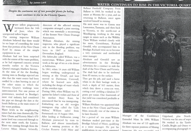 Bendigo Historical Society Inc.
Newspaper - LONG GULLY HISTORY GROUP COLLECTION: WATER CONTINUES TO RISE IN THE VICTORIA QUARTZ
Photo of a newspaper article titled Water Continues to Rise in the Victoria Quartz by James Lerk. Article mentions William Abraham who was the mining inspector, who played a significant role in the flooding problem. Water levels had risen dramatically. Water flowed from one mine to another where they were connected. Article also mentions Abraham's birthplace, his early start to work at the age of 10 as a tin dresser at Ashburton, Devonshire, England and his working life after he migrated to Australia at the age of 19. His career in Australia is also mentioned. The article is accompanied by a photo of Abraham with his horse.bendigo, history, long gully history group, the long gully history group - water continues to rise in the victoria quartz, james lerk, william abraham, new chum reef, matthew stevens, south bellevue, new chum and victoria mine, lazarus mine, new chum drainage association, william abraham snr, mary kane, lady miltoa (ship), cricket reserve gold mine, ballarat freehold company, wallaby mine, richard grenfell, bendigo advertiser, bendigo school of mines, confidence extended mine -
 Bendigo Historical Society Inc.
Letter - KANGAROO FLAT GOLD MINE COLLECTION: FILE RECORD RE CENTRAL DEBORAH TOURIST MINE STUDY, 3rd August 1983
File memo, from D.F. Evans, 3 August, 1983 re Central Deborah Tourist Mine Study, discussing the report from John Reynolds now lodged in the Preston Library. Main aspects of concern in report to Bendigo Mining NL are: 1. Proposal to redevelop shaft and establish tourist access 2. Calculation of volume of water in old flooded workings in North Deborah, Deborah, South Deborah and Deborah No. 2 mines 3. Volume of water involved in dewatering Central Deborah to 90m below the surface 4. Long term pumping reate required to control groundwater influx, estimated to be 90,500 gallons/day.bendigo, gold mining, central deborah gold mine, central deborah gold mine, dewatering, ground water, mining, bendigo mining nl -
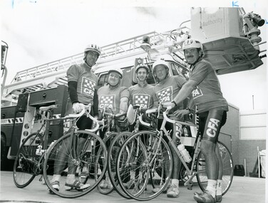 Bendigo Historical Society Inc.
Photograph - BENDIGO ADVERTISER COLLECTION: BIKES, 1996
8091.264a Photograph: Five men in CFA Tops with racing bikes, Fire truck behing. On Rear of Photo: 15/3 PH/WG Murray to Moyne charity ride L to R John Flood, Barry Cole, Bob Ellis, Dirk Vetch, Rod Roberts. Stick on label on rear: Editorial PMT Order Pub Date 5/4 Size Width 36:6 Depth 14.5 Section National, Page 2, Description Bike Riders. Special instructions/percentage S/S Order W Date 4/4 8091.264b Newspaper Article Bendigo Advertiser 5/4/1994recreations, sports, cycling, bendigo advertiser -
 Port Melbourne Historical & Preservation Society
Photograph - Smallpage children, Douglas Smallpage, 1934
.01 - Small B&W photo of flooded Crichton Avenue, Port Melbourne .02 - B&W photo of Smallpage family in backyard, Nov 1929 .03 - B&W photo of Smallpage children in backyard, Dec 1927 .04 - B&W photo of Smallpage children, Dec 1927 .05 - B&W photo of Smallpage children, Dec 1928 .06 - B&W photocopy of .02 .07 - B&W photocopy of .03 .08 - B&W photocopy of .02, Nov 1929 .09 - B&W photocopy of .05 .10 B&W large version of .01families, built environment - domestic, doug smallpage, crichton avenue -
 Kew Historical Society Inc
Photograph - Demolishing the Zig-Zag Bridge, 1929
Henry Beater Christian (1886-1962) , was a descendant of one of the earliest settler families in Kew. Employed at the Kew Asylum as a 'public servant', he was a skilled amateur photographer, photographing numerous scenes in Kew and on his travels around Victoria. The majority of his photographs date from 1916 to 1929. His finest photographs are housed in two photograph albums. Rare photograph of the demolition of the Zig-Zag Bridge linking the two asylums on either side of the Yarra River.Digital copy of a photograph from page 16 of the 47-page photograph album containing 261 gelatinous silver images, loaned by Diane Washfold with permission given to digitise and hold a copy in our collection. The Zig-Zag Bridge linked the grounds of the Yarra Bend and Kew Asylums. The wooden bridge was constructed in the 1870s and lasted through numerous floods until its destruction in 1929. A horizontal structure, the walkway was reached via a wooden staircase on the Kew bank of the river. The steps were required due to the different levels of the banks on this stretch of the river. This night-time photograph shows the remaining parts of the bridge being destroyed by fire."Demolishing Zig-Zag / 6. 1929"henry beater christian (1886-1962), landscape photography, kew (vic.) — yarra river, christian-washfold collection, photograph albums, zig-zag bridge -
 Kew Historical Society Inc
Map, MMBW, MMBW Plan No.117 Heidelberg & Kew, 1900-1910
The Melbourne and Metropolitan Board of Works (MMBW) was established by an act of the Victorian Parliament in 1890 to prepare for and to implement a sewerage and water reticulation system across what was then inner Melbourne, its surrounding and middle distance suburbs, including Kew. The MMBW was disbanded in 1991.The map collection of the Kew Historical Society has at its core the historic maps assembled and originally stored in the City Engineer's Department of the City of Kew. These include maps in a number of scales. The vast majority of maps were produced by the MMBW in the first two decades of the twentieth century, and are solid working maps, backed by linen for durability. These maps are historically significant to Kew, the City of Boroondara and to the history of the development of state utilities in Victoria. A number of the Kew maps have additional details added by former municipal officers, including the levels reached by various floods. As these were working documents, information was added to them long after the period of their initial production and distribution.Early map of part of the Borough of Kew, created in the early twentieth century, at a scale 160 ft to 1 inch. The map covers what was then the north eastern part of Kew showing the natural landscape and limited development on the south side of the Yarra River. In the Kew section, south of the river, the land is occupied currently by the Greenacres and Kew Golf Clubs. The map shows the extent of urban development by that time and the outlines of the few built structures in the municipality. The height above sea level of all parts of the landscape are indicated numerically in feet. Contour lines and the levels of historic floods were added in ink to the map at a later stage. MELBOURNE AND METROPOLITAN BOARD OF WORKS / PLAN NO. 117 / HEIDELBERG & KEW melbourne & metropolitan board of works, mmbw maps, borough of kew, cartography, mmbw plan no. 117, kew (vic.) -- maps, heidelberg (vic.) -- maps -
 Orbost & District Historical Society
black and white photographs, Howard D. Bulmer, first half 20th century
This bridge was built in the 1920s as a road and rail bridge, and was partly washed away by flood waters in 1934. After the end of the first World War the Victorian Railways considered an extension of the railhead across the river at Orbost, and in 1922 a new timber and steel girder structure, a joint Country Roads Board — Victorian Railways venture, was built and completed at a cost of £41,000 (the steel girders came from the Flinders Street viaduct reconstruction). Subsequently it was decided not to take the railway across the river, and the bridge has only been used by road traffic. This is a pictorial record of an early bridge across the Snowy River at Orbost.A large black / white photograph of the Orbost Snowy River bridge. There is a large copy as well as a postcard copy in sepia.on front - Snowy River Bridge Orbost H.D. Bulmer - photo - Lake Tyers.snowy-river-bridge-orbost -
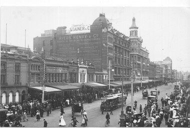 Melbourne Tram Museum
Photograph - Black and white - Swanston St looking north from Flinders St, c1900
Photograph of Swanston St looking north from Flinders St. There is one cable tram set in the view along with many horse-drawn vehicles, bicycles, and many pedestrians. In the background is part of Young and Jackson's Princes Bridge Hotel, a sign for "New American system without pain Dentistry", Ayers Henry & Co. clothing, Stainer & Co., Keystone Elgin watches. Visible is an open wire telephone lines on poles. Photo c1900. Understood that the photo appears in the James Flood book of Melbourne photos.Yields information about Swanston St, c1900.Black and white photograph on paper.trams, tramways, swanston st, cable trams -
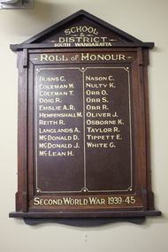 Wangaratta RSL Sub Branch
Memorabilia - Honour Board, South Wangaratta School and District, c1945
The original South Wangaratta Primary School served the district for over 110 years and closed in December 1985 before moving to new premises. When the school closed in 1989 and with the demise of the South Wangaratta Hall due to flooding in the 1990's the Honour Board was wrapped in a blanket and stored in a shed for the best part of 10 years before being donated to the Wangaratta RSL for safekeeping and permanent display. South Wangaratta School and District Honor Board lists names of students who served during WW2Timber Honour Board with two columns consisting of twenty one names in gold paint.School and District South Wangaratta. Roll of Honour. Second World War 1939-45world war 2, south wangaratta, honour board -
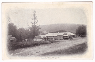 Marysville & District Historical Society
Postcard (item) - Black and white postcard, Keppel's Hotel, Marysville, Unknown
An early black and white postcard from Keppel's Hotel in Marysville. The hotel was originally built and opened by the Keppel Family in 1865. The Keppel's Australian Hotel was the first hotel to be opened in Marysville. The Keppel Family were among Marysville's earliest pioneering families. On the reverse of the postcard is a hand written message and a postage stamp. The postcard was posted on September 7th 1906.An early black and white postcard from Keppel's Hotel in Marysville.Post Card The Address to be written on this side SE 7/ 06/ VICTORIA Miss Davis/ "Bonnie View"/ Upper Maffra West. Wed./ Received your pretty little/ puss. It was so wet here the/ end of last week both/ the Jack + Honey were flooded./ It is lovely today. The/ holidays begin today. None/ of our people went to the Show/ or Exhibition. With love to all/ I have 129 ??? from E.C.marysville, victoria, australia, keppel hotel, keppel's australian hotel, australian hotel, keppel family, maurice john keppel, accommodation, postcard -
![Studley Park [Toll] Bridge, Kew](/media/collectors/550653872162f11fb04854aa/items/579ebf04d0cdd117c4c0815f/item-media/579ebf3ad0cdd117c4c0953e/item-fit-380x285.jpg) Kew Historical Society Inc
Kew Historical Society IncPhotograph, Studley Park [Toll] Bridge, Kew, 1870s
‘Studley Park Bridge’ or ‘penny bridge’ linked Church Street in Abbotsford and what is now Yarra Bend Park. The privately constructed bridge opened in 1857, gaining its popular name from the toll charged at the Abbotsford end. The engineer of the 485ft wide bridge was Mr. Austin and the builder was ‘Mr Grant, who threw the bridge over the Niagara’. Following the opening of Johnston Street Bridge, declining tolls led to the Bridge falling into disrepair. Badly damaged by the flood of 1891, the Bridge was compulsorily acquired by the Government in 1899, and later dismantled and sold for firewood.This work forms part of the collection assembled by the historian Dorothy Rogers, that was donated to the Kew Historical Society by her son John Rogers in 2015. The manuscripts, photographs, maps, and documents were sourced by her from both family and local collections or produced as references for her print publications. Many were directly used by Rogers in writing ‘Lovely Old Homes of Kew’ (1961) and 'A History of Kew' (1973), or the numerous articles on local history that she produced for suburban newspapers. Most of the photographs in the collection include detailed annotations in her hand. The Rogers Collection provides a comprehensive insight into the working habits of a historian in the 1960s and 1970s. Together it forms the largest privately-donated collection within the archives of the Kew Historical Society.A print, taken in the 1960s by Dorothy Rogers, from an original albumen silver photograph now in the collection of the Kew Historical Society. The photograph shows the toll bridge (also known as the Penny Bridge) from the northern end."P[enny] Toll Bridge - built 1857. from old photo"studley park bridge, penny bridge, bridge, timber bridge, toll bridge -
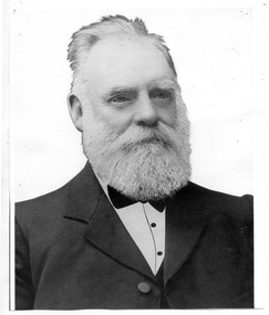 Tarnagulla History Archive
Photograph of John Shields Simpson, circa 1880s
Murray Comrie Collection. Information written by Murray Comrie: John Shields Simpson was born in Scotland in 1831, came to Victoria in 1853 and after mining for a time took up land at what was later to be the Nick O'Time Lead at Poseidon. He took up a store at Newbridge and in 1905 built a hotel alongside the store. Both were severely damaged in floods of the Loddon River in 1909. He was elected to the Tarnagulla Borough Council in 1882 and retained his seat until 1915 when he resigned. He was Mayor of the Borough on five occasions. Monochrome photographic portrait of a bearded man.Accompanying note identifies subject as John Shields Simpson.borough of tarnagulla, john shields simpson, mayor, council, local government, local people, newbridge, store, hotel