Showing 1442 items matching " lithographers"
-
 Glenelg Shire Council Cultural Collection
Print - Lithograph, Early View of Town of Portland, 1890-1905
Displayed in History House. Removed from frame and rehoused, January 2007. Previously owned by Murray Wilson, 1923-1989.Donated by Mrs Betty Wilson in memory of her husband, Murray Wilson (1923 - 1989)Lithograph of a drawing of Portland, viewed from an elevated position. Cliffs on foreground right curve towards a series of piers. To right is a church and a series of houses on blocks, with a wide street in front. Couta boats, row boats and steam ships are in the harbour, one steamship is berthed at the end of a long pier with a railway track leading from it. In background the coastline curves around the harbour, with a lighthouse evident on a bluff at upper left of image.Front: (no inscriptions) Back: Murray F. Wilson/from E. Wilson (on backing board, now removed) -
Creswick Campus Historical Collection - University of Melbourne
Photograph - Six photographs of the VSF, Victorian School of Forestry, Creswick in 1971
Six colour photographs of VSF, Victorian School of Forestry, Creswick in 1971. Four being exterior images of the grounds and buildings. Two being interior images from the VSF Library. Images include: VSF Building, old Creswick Hospital, front and rear, VSF Library, VSF Laboratory building, and grounds. The interior images are of the VSF Library, students, furniture, roll of honour, fireplace, VSF plaque, lithographs, Library books. -
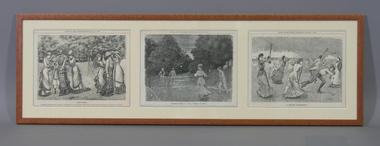 Tennis Australia
Page from Magazine, 1877-1881
Three pages from Punch magazine, each featuring a monochrome lithograph depicting tennis matches. (1) from issue July 7, 1877; image with caption 'LAWN TENNIS'; (2) from issue August 24, 1878; with caption 'WHERE THERE'S A WILL THERE'S A WAY'; and (3) from issue November 3, 1881; caption 'A MODERN TOURNAMENT'. Materials: Ink, Paper, Cardboard, Wood, Glass, Metal, Adhesive labeltennis -
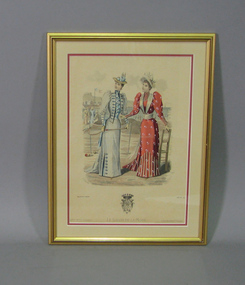 Tennis Australia
Lithograph, Circa 1880
A colour lithograph issued by the Salon de la Mode, featuring two women wearing high fashion of the late 19th century, posing next to a tennis court net. The woman on the left is holding a racquet. Below is the image of a coat-of-arms, with the monogram 'HVP', which is that of the director of the Salon de la Mode, Henry Petit. One of the engravers is identified as 'Lefranco'. Materials: Paper, Ink, Cardboard, Metal, Paint, Wood, Glasstennis -
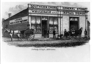 Tarnagulla History Archive
Photographic copy of lithograph: Pierce's Southern Cross Store, Tarnagulla, Pierce's Southern Cross Store, Tarnagulla, circa 1850 to 1871
Murray Comrie Collection. John Pierce's Southern Cross General Store, a wholesale grocer and spirit merchant was put up for sale after Pierce's death in 1871. It was later incorporated into the Flour Mill complex. De Gruchy & Leigh was a publishing and printing firm operating in Melbourne and regional Victoria from the late 1850s until the mid 1860s. The company published almanacs and guidebooks as well as prints (portraits, views and genre scenes), maps and architectural plans (Source: National Portrait Gallery, Canberra). This is a copy created from another item in the collection - a printed piece of paper which was either a packing label or receipt form used at the company or a brand label for bottles, perhaps for wine made by the proprietor. Copy probably made by Murray Comrie in the 1970s. Monochrome photographic copy of a lithograph. Depicts a building with glass front windows and signage stating 'J. Pierce Wine & Spirit Merchant' and 'Southern Cross General Store, Wholesale and Retail Depot'. In front of building on road are two horses hitched to carts and men standing on cart and in front of store. This store was located on the south-eastern corner of Commercial Road and King Street. The building was later incorporated into the flour mill complex.tarnagulla, commerce, shops, stores, shopping, food, alcohol, horses, transport, buildings, commercial road, main street, john pierce, southern cross general store -
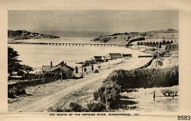 Flagstaff Hill Maritime Museum and Village
Postcard - Postcard Folder - scenes, George Rose, Rose Stereographic Company, Rose Series Picturesque Views of Warrnambool Australia [Warrnambool], 1880-1942
This postcard folder contains lithographs of photographs taken locally by Georg Rose between 1880 and 1942. He reproduced them at his company's premises, the Rose Stereographic Company at Armadale, Victoria. The postcard folder was purchased as a Warrnambool souvenir by the donor's parents around 1945 to 1950. Interestingly, the city on the cover is printed as "Warrambool", which is a location in New South Wales, but the postcards within all have the locations and text of Warrnambool. The photographs include the 'new' concrete bridge, built in 1922 to replace the original bridge, built in 1872. The boathouses belonging to Proudfoots and to Flett/Fanny Nelson are also pictured on the Hopkins River mouth. The twelve photographs included locations connected to other items in our Collection. The photographs are titled: - b. The Avenue and War Memorial. Warrnambool. Vic. c. The Blow-hole. Thunder Point. Warrnambool. Vic. d. Botanical Gardens. Warrnambool. Vic. e. Eagle Rock. Warrnambool. Vic. f. The New Concrete Bridge and Breakwater. Warrnambool. Vic. g. Liebig Street. Warrnambool. Vic. h. Looking to Thunder Point. Warrnambool. Vic. i. The Beach. Warrnambool. Vic. j. Hopkins Falls. Warrnambool. Vic. k. Shelly Beach. Warrnambool. Vic. l. The Mouth of the Hopkins River. Warrnambool. Vic. m. Panorama of Warrnambool. Vic. [Kepler Street towards Presbyterian Church on Spence St] George Rose, 1861-1942: - famous for his Late 19th and early 20th century photography. He was born in Clunes, Victoria, and was in his 20th year when he founded Rose Stereograph Company in 1880. He took the opportunity of a popular trend of the times to produce stereographs, pairs of almost duplicate photographs which appeared to be in 3D when viewed in a handheld stereo viewer. By the 1920s these lost their popularity, so he used his photographic skills to produce cards and postcards of scenes and people. The photographs in this postcard folder were taken between 1880 and 1942 by the renowned Victorian photographer George Rose. The locations match photographs and postcards in our collection that were taken at different times. A comparison between them shows the changes over time in the land and bay, the buildings and other structures, transportation and even the fashions of the times, building the story of our local history.This copy of a postcard folder has a blue-grey textured rectangular card cover with a sketch of a rose on the front along with the name of the postcard series. the location of the series' focus, the producer's details and lines for adding an address. The folded cover contains a long, concertinaed page with six titled photographs on each side, totalling twelve in all. Interestingly, the cover has the location name of "Warrambool", a place in NSW, instead of Warrnambool, the location of all of the photographs inside. The folder contains scenes from Warrnambool and nearby popular areas including Lady Bay, Port of Warrnambool, Warrnambool Breakwater, Viaduct, Merri River Footbridge, the Hopkins River Mouth, with Proudfoot’s and the Fanny Nelson/Flett boathouses. The cover has a sketch of a rose and inscriptions. The photographs for the lithographs were taken prior between 1880 and 1942 by well-known Victorian photographer, George Rose, Rose Stereograph Company of Armadale, Victoria.Image: [Rose with rosebud and leaves] Printed: "Rose Series / Picturesque Views of / WARRAMBOOL / AUSTRALIA" [correct spelling is WARRNAMBOOL] "PUBLISHED BY / ROSE STEREOGRAPH CO / ARMADALE. VIC." Printed lines (3) for an address. Printed rectangle [ ] for attaching a stamp.flagstaff hill maritime museum and village, great ocean road, shipwreck coast, warrnambool, flagstaff hill, flagstaff hill maritime museum, flagstaff hill maritime village, warramble, postcard, postcard folder, warrnambool scenes, picturesque views of warrnambool, picturesque views of warramble, lady bay, port of warrnambool, breakwater, warrnambool breakwater, viaduct, merri river footbridge, merri river suspension bridge, suspension footbridge, merri river mouth, hopkins river mouth, proudfoot's, fanny nelson, nelson's boatsheds, nelson's boathouse, boathouse, hopkins river boathouses, flett's boathouse, flett, george rose, image of a rose, rose series, rose stereograph co, rose stereographic company, lighograph, armadale victoria, lady bay beach, beach scene, lower light, concrete footbridge, 1922 footbridge, viaduct road, rose postcard, new concrete bridge, 1945, 1890, 1922, small footbridge, 1872 footbridge, 1872, merri river estuary, stingray bay, postcards -
 Queenscliffe Maritime Museum
Book - Royal Atlas 1861, Keith Johnston, The Royal Atlas of Modern Geography, 1861
Atlas of the word in 1861105 page leather bound atlas containing some coloured illustrations of maps of the countries of the world up to 1861. Published by William Blackwood & Sons, 1861. Folio [51x34cm] size with 9 pages of introductory text followed by 48 double-page spread and part coloured maps.non-fictionAtlas of the word in 1861geography, world atlas, keith johnstone -
 Melbourne Legacy
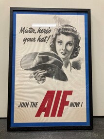
Poster, Join the AIF now!, 1941
A framed Australian Commonwealth Military Forces Second World War recruitment poster by Richard Haughton James (source AWM). The poster is an offset lithograph on paper framed by a blue border, mounted in a black frame. It is an early example of the work of the Commonwealth Advertising Division, set up in 1941 within the Department of Information, primarily to advertise recruitment drives for men's and women's services, munitions work, war loans and national savings campaigns.A record that Legacy holds some war memorabilia as Legatees were once solely returned servicemen.Black and white sketch of a wartime lady holding a soldier's hat used as a recruiting poster in a black frame.Test of the poster "Mister, here's your hat! JOIN THE AIF NOW!"world war two, recruitment, aif -
 Bendigo Historical Society Inc.
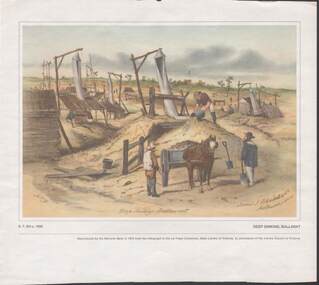
Painting - CAROL HOLSWORTH COLLECTION: 1970 NATIONAL BANK PAINTING 'DEEP SINKING - BALLARAT'
1970 National Bank painting reproduction 'Deep Sinking , Ballarat' by S.T.Gill c. 1855 Below the picture title the words - Reproduced by the National Bank in 1970 from the lithograph in the La Trobe Collection , State Library of Victoria , by permission of the Library Council of Victoria .Also on the painting is written -James J Blondell & Co Melbourne 1855. The painting shows mine shafts with windsails and windlasses a horse and cart , three men in the foreground several in the distancepainting, watercolour, gold diggers -
Bendigo Historical Society Inc.
Booklet - City of Bendigo Jubilee 1855-1905, April 1905
Cord bound booklet of 26 pages with red and brown title and Bendigo Crest on front cover. 'City of Bendigo Jubilee 1855-1905' A short Resume of Municipal Progress issued by A.Dunstan, Mayor, April 1905 Illustrated with B&W photos of the era and chronological list of events. Photos of Councillors from Sandhurst Borough, Sandhurst City and Bendigo City. Printed by J.B.Young, General Printer, Lithographer, Bookbinder etc., Lyttleton Terrace, Bendigo city of bendigo, jubilee, 1855-1905 -
 Tennis Australia
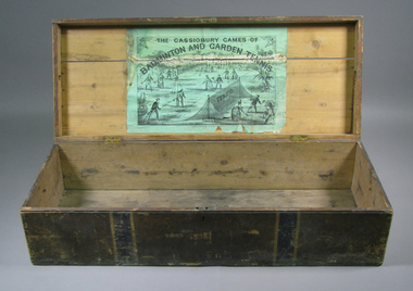
Chest, Circa 1876
An empty chest, originally housing a lawn tennis and badminton set. Black and green lithographic print features couples playing mixed doubles tennis and badminton in Cassiobury Park, with Cassiobury House in the background. Inscription: THE CASSIOBURY GAMES OF/BADMINTON AND GARDEN TENNIS/LONDON/DEAN & SON 160 FLEET STREET. The hourglass court used in Wingfield's version of lawn tennis is depicted in this lithograph. Materials: Wood, Metal, Ink, Glue, Paint, Paper, Lacquertennis -
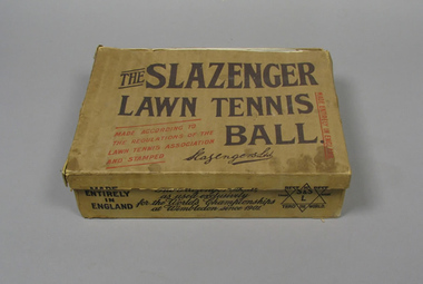 Tennis Australia
Ball container, Circa 1938
An empty Slazenger (UK) 'Lawn Tennis Ball' box. Printed on lid: 'MADE ENTIRELY IN ENGLAND/MADE ACCORDING TO/THE REGULATIONS OF THE/ LAWN TENNIS ASSOCIATION /AND STAMPED'. On front of box is printed: 'AS USED EXCLUSIVELY/FOR THE WORLD'S CHAMPIONSHIPS/AT WIMBLEDON SINCE 1901'. On side of box is printed: 'EXCLUSIVELY ADOPTED FOR/USE AT THE OLYMPIC GAMES/1904, 1908, 1912 AND 1920'. Elaborate colour lithograph label adhered to underside of lid. Materials: Ink, Cardboard, Papertennis -
 Geoffrey Kaye Museum of Anaesthetic History
Book, Longman, Brown, Green and Longmans, Physical Description of New South Wales and Van Diemen's Land. Accompanied by a geological map, sections, and diagrams, and figures of the organic remains, 1845
Dr. Gwen Wilson, Emeritus historian, gifted this book at ANZCA's first independent Annual Scientific Meeting held in Launceston in 1994. Dr Wilson presented this gift after her speech about the life of William Russ Pugh and his significant contribution to anaesthesia in Australia. It is unclear as to how the book came into Dr Wilson's possession. Published in London, 1845, for Longman, Brown, Green and Longmans, this book was formally owned by general practitioner Dr William Russ Pugh, being the first medical practitioner in Australia to administer ether anaesthetic on 7 June 1847, in Launceston. The author of the book, P E De Strzelecki acknowledges Pugh for his assistance during his stay in Launceston and for allowing him the use of his laboratory for the analysis of the soils and minerals that were subsequently reported in this book (Page 131). Tan coloured cloth book with an embossed circular motif on the centre of the front and back cover. The same embossed motif is repeated four times along the spine of the book. An embossed design of small, four petal flowers borders the edge of the front and back cover. The title of the book 'Strzelecki's New South Wales and Van Diemen's Land' is printed in gold on the spine. The cloth has come unstuck at various places around the spine and a small section is missing from the base of the spine. The cover is worn and has numerous dark stains possibly from mould. The book contains 19 engraved and lithographed plates. This includes a handcoloured octavo folding, geological map, bound as a frontispiece, depicting the NSW coast down to Gippsland and Tasmania, a fold out single colour geological cross section of the Newcastle Coal Basin, 14 plates illustrating shellfish and flora and three tinted lithographs. Single page maps at the back illustrate wind patterns around Australia. [front title page, two black ink stamps that have bled through to the next page] W R.PUGH [front title page, black ink, cursive writing] H Grant \ 5 May 1910 [front title page, pencil, cursive writing, written around Pugh's stamp] Purchased from \ (unrecognizable script) [front title page, previous owner's name was rubbed out and consequently tore the page making the entry unreadable] [Inner back cover, bottom LHS, blue stamp] BOUND BY \ WESTLEYS & \ CLARK \ LONDON [Inner front cover, bottom LHS, black and purple ink] P65 \ 76 \ 78 \ 98 \ 163 \ 164 \ 217strzelecki, van diemen's land, wilson, gwen, pugh, william, launceston, green and longmans -
 Bendigo Historical Society Inc.
Document - COHN BROTHERS COLLECTION: BROWN PAPER BAG LABELLED MISCELLANOUS DOCUMENTS
String bound Brown paper parcel labelled 'Miscellaneous Documents. Hundreds of documents enclosed appear to date from mid-1890's to mid 1900's. Inside surface of paper has attached torn advertising sticker of F W Niven, Lithographers, Printers, & Book Binders' 40-42 Flinders St Melbourne addressed to Cohns Bros Brewery ,based upon an Australian 15cm x 12 cm Red Ensign flag.bendigo, industry, cohn bros brewery -
 Bendigo Historical Society Inc.
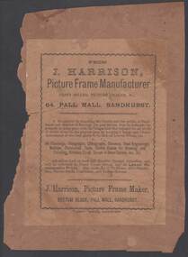
Document - J HARRISON PICTURE FRAME MANUFACTURER, 64 PALL MALL, SANDHURST
19th Century J Harrison,Picture Frame Manufacture of Bottom Block, 64 Pall Mall Sandhurst stick-on advertising leaflet. Attached to brown paper fragment. J Harrison was thanking friends and public of Sandhurst and district of Bendigo for past favours. Kept a large choice at lowest prices of Oil Paintings, Oleographs, Lithographs, Chromos, Steel Engravings, Mottoes, Illuminated Texts, Choice Copies for Drawing and Painting, Birthday Cards, Scraps in Great Variety, & etc.News Office Sandhurst.bendigo, industry, printing, j harrison bottom block, 64 pall mall sandhurst. 19th century printing techniques. -
 NMIT (Northern Melbourne Institute of TAFE)
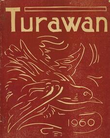
Magazine: Collingwood Technical School 1960, Turawan: the magazine of Collingwood Technical School 1960
The school magazines present a record of each year's school events such as staffing, programs, outings and includie student writings and drawings, reports and photos of events and teams. The cover of the monthly is a coloured lithograph of a bird. Copies held include May, June, July, August and September 1960. The cover of the annual edition consists of a simple black and white cover with title, the year and the school logo. Annual editions held include 1960, 1962, 1963, 1969. The school changed its name to Collingwood Technical College and the cover of these magazines feature a black and white Magpie. Magazines held for this entity range from 1970-1975.collingwood technical school, school magazines, collingwood technical college, nmit. -
 Ringwood and District Historical Society
Map - Public Land Sale by Thomas Ham, 2000 Acres for Sale - Crown Sections 20, 23, 24 - Ringwood, Victoria - 1855
Two 1850s surveyor's maps on cardboard backing showing area from Melbourne extending East beyond Bulleen and Nunawading. Detailed description of lots for sale and navigational directions to the property from Richmond by Thomas Ham, Victorian public servant, map maker, publisher, lithographer and original Ringwood land owner. Inset map enlarging area between Yarra River and Dandenong Creek, with southern boundary of allotments later forming part of Oban Road, North Ringwood.TRANSCRIPT: "This really valuable Property is now offered to the public for sale, in lots to suit purchasers at the Iow rate of £1 per Acre for 80 acres and upwards, and £1.10s per Acre for any smaller portion. Terms of payment Half Cash, Balance in 6 and 12 months, bearing 8 per cent interest. The Estate is well wooded with Gum, Cherry Tree and Stringy Bark, with Wattle in the valleys of the several creeks. Every lot is Staked and Trenched at the corners marked on the Plan thus - The Surveyor has carefully sub-divided the Property, in order to give every Farm a Creek for Water, Valley for Cultivation, and Hills for House and Grass Paddock. The ROADS have been very carefully laid out so as to give a firm, well drained, and nearly level road to each Homestead. Intending purchasers can readily find the property by the following directions, viz: Start from Richmond Bridge, at Hawthorne, then take the left-hand road to KEW. When at the "Woodman Inn", take the Cotham Road to the right, bearing due east, keep this Road, passing Trainor's "White Horse" Inn, and before you leave the fences, you will see calico bills (see margin) nailed to the Trees on the bush track leading to the Upper Yarra country, follow the Bills till you come to the SOUTH boundary line of the Property, which bears East and West (see Plan) where you will see Bills nailed up "THIS PROPERTY FOR SALE, etc." The Bills from Town lead direct to where Mr. Jull is erecting his Store, and arrangements have been made with him to show the lots to intending purchasers free of charge. At the respective corners of the lots the Bills are nailed up double, with numbers to denote the lot, and that the corner stake is adjacent. Any parties wishing to proceed to the property by way of BULLEEN will find Bills nailed on the Trees, commencing at the NEW INN, at "Wilson's Slip Rail." Keep this Track till you come to the Log Bridge, over the Deep Creek at Bloxhome's Paddock; go through the land now being cleared; keep the track over the hill till you come to an Iron House, you will then be on the property, which Iies to the North and East as per Plan. Follow the Bills till you come to Mr. Jull's Store, etc. etc. Further particulars can be had from the Agent for the Property. THOMAS HAM. " -
 Bendigo Military Museum
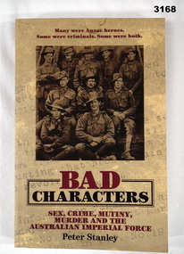
Book - BOOK, WW1, Peter Stanley, Bad Characters, 2010
Many were ANZAC Heroes. Some were criminals. Some were both. Leading war historian Peter Stanley reveals the citizen soldiers the army regarded as bad characters.Title: Bad Characters, Sex, Crime, Mutiny, Murder And The Australian Imperial Force. Soft cardboard cover, with black & red printing on front, spine & back. Mottled yellow with light grey print background. Front cover displays sepia photo of a group of ten soldiers in uniform. Back cover displays sepia colour photo of a group of soldiers, some in uniform. 286 pages, cut plain paper, illustrated in black & white, photos, line drawings & lithographs.books-biography, military history-army, bad, characters -
Bendigo Historical Society Inc.
Map - REDESDALE : COUNTY OF BENDIGO, 25 -10-77
Map. Redesdale, County of Bendigo, County of Dalhousie, County Of Talbot, Lyell, Kimbolton, Langwornor, Spring Plains, Glenhope, Emberton, Metcalfe, Hawkestone, River Coliban, Campaspe River, Back Creek. Photo-Lithographed at the Department of Lands and Survey, Melbourne by J. Noune, 25-10-77. Compared with original plans 12-11-78 M. Kemp. J.C.Kelsh, Draughtsman April 1876. Examined by E. Downward, 5-6-77. (number 121 in map cupboard 1)J. Nounemap, bendigo, redesdale -
Bendigo Historical Society Inc.
Map - TARNAGULLA : COUNTY OF BENDIGO, 13-5-22
Map. County of Bendigo, County of Gladstone.Inglewood, Glenalbyn, Kingower, Moliagul, Waanyarra, Laaneoorie, Woodstock, Loddon River, Township of Tarnagulla, Township of Newbridge, Township of Llanelly, Dunolly to Inglewood Railway, Tarnagulla Rifle Range, Laurie Station, Bullabul Creek, Arnold Township, Arnold Railway Station. Photo-Lithographed at the Department of Lands and Survey, Melbourne by W.J. Butson, 13-5-22.Price 1/-.By authority A.J. Mullett, Government Printer, Melbourne. (number 118 in map cupboard 1)A.J. Mullett, Government Printer, Melbourne.map, bendigo, tarnagulla -
Bendigo Historical Society Inc.
Map - HARCOURT : COUNTY OF BENDIGO, 23-3-10
Map. County of Bendigo, County of Talbot, Sutton Grange, Ravenswood, Walmer, Faraday, Castlemaine, Axe Creek, Barkers Creek, Melbourne to Echuca Railway, Victorian Water Supply in Connection with Barkers Creek Reservoir. Victorian Water Supply Reserve, Mt. Alexander State Forest. Three areas reserved for Sericulture (Silkworms). Photo-Lithographed at the Dept. of Lands and Survey, Melbourne by T.F. McGauran 23-3-10. Price 1/-. (number 101 in map cupboard 1)T.F. McGauranmap, bendigo, harcourt -
Bendigo Historical Society Inc.
Map - HEATHCOTE : COUNTY OF BENDIGO
Map. Heathcote, County of Bendigo, County of Dalhousie, Knowsley, Knowsley East, Dargile, Costerfield, Warrowitue, Tooborac, Langwornor, Argyle Station Ground, Bendigo to Heathcote to Kilmore Railway Line, Township of Heathcote, C.R.B. Main Road. Mount Ida Creek, Wild Duck Creek, Meadow Valley Creek. By Authority H.J. Green, Govt. Printer, Photo-Lithographed at the Department of Lands and Survey, Melbourne by W.J. Butson, Price 1/-. (number 91 in map cupboard 1)H.J. Green Govt. Printer.map, bendigo, heathcote -
 Bendigo Historical Society Inc.
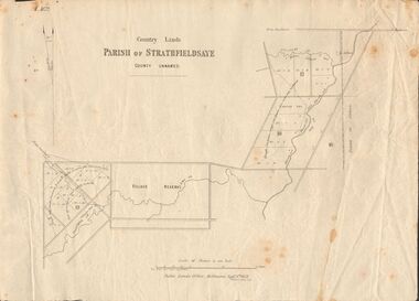
Document - MARKS COLLECTION: MAP OF PARISH OF STRATHFIELDSAYE 1858, 8th September, 1858
Buff coloured document. On top 'Country Lands, Parish of Strathfieldsaye, County Unnamed'. On bottom 'Scale 40 chains to an inch. Public Lands Office, Melbourne Sept 8th. 1858. William Collis, Lith ( lithographer )'. Map shows Village Reserve on Emu Creek, road from Sandhurst, Sheepwash Creek and Splitters Creek. Wellington Hotel marked on map near intersection of Sheepwash Creek, Axe Creek and Emu Creek. Axe Creek Pound near Splitters Creek.map, bendigo, parish of strathfieldsaye 1858 -
 Bendigo Historical Society Inc.
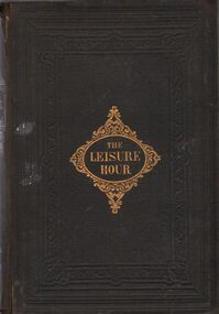
Book - HARRIS COLLECTION: 'THE LEISURE HOUR'
Black cover book, 828 pages, gold embossed 'The Leisure Hour' on front cover. Written inside front cover in black pen 'The Honourable F.F. Casey, Members of Parliament of Victoria, Australia' (writing appears childlike ) Three newspaper cutouts stuck to same page, J. Casey, Sir J. O'Shanessy and E.L. Zox? (difficult to discern) Written on top of title page in black pen 'Harriet Harris'. Harriet Harris was the mother of George Harris and the wife of Jonathan Harris, Axedale, Victoria. 'The Leisure Hour 1866' and 'London, Paternoster Row and 164 Piccadilly' on title page, surrounded by lithographed images of foliage and families reading books. Further cutting from newspapers stuck on first blank page 'Death of the Hon Francis Ormond, MLC and 'Spare the Horse'. Both stuck over child's drawings of a kangaroo and bird (written underneath 'The Buphaa Africanus' Four more cuttings on back blank page ' Policeman shot by a burglar'. 'The funeral of the late Mr. J.B. Watson', lithograph images of Hon John O'Shanassy, MLC and W.J.T. Clarke Esq.harriet harris, axedale, education -
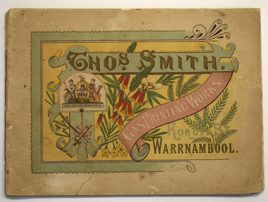 Warrnambool and District Historical Society Inc.
Booklet - Printer's Advertising Booklets, Thomas Smith, Printer, Koroit St. Warrnambool, Thos. Smith Gas Printing Works Koroit St. Warrnambool, c. 1900
A booklet advertising the work of Warrnambool printer Thomas SmithThese are two copies of a advertising booklet.The cover is multi-coloured and includes an ornamental border, a crest, scroll work, images of flowers and fronds and printed headings. One copy is missing its cover and the cover of the other copy is detached The booklets contain black and white photographs and drawings, reproductions of the printer's work and a sketch map of the Warrnambool C.B.D. The booklets are bound with cotton thread.non-fictionA booklet advertising the work of Warrnambool printer Thomas Smith 19th century warrnambool businesses, thomas smith printer, lithographer warrnambool -
 Eltham District Historical Society Inc
Document - Map, Victoria. Department of Crown Lands and Survey, Town of Eltham, Parish of Nillumbik, County of Evelyn, 2 October 1929
Township of Eltham, Parish of Nillumbik, County of Evelyn / lithographed at the Department of Lands & Survey Melbourne 5th June 1888, amended 2 October 1929 This amendment from the 1888 original shows the reserve for the the State School marked as permanent with dimensions added to Main Road and block frontages along Main Road between Mount Pleasant Road and Dalton Street and Metery Road Possibly photocopied from a copy held at PROV by Harry Gilham whilst resaerching Eltham Primary School history in 1995.a. armstrong, a. lavard, arthur c. allan, arthur c. allen, b. bowatere, baxter street, benjamin oliver wallis, bolton steet, c. souter, c.s. hain, cemetery reserve, charles brown, charles newman, charles symons wingrove, christopher caldwell, church of england, d. anderson, dalton street, david ballard, e. james, e.m. peck, edward dumaresq, eltham town, ely street, f.e. falkiner, f.m. peck, falkiner street, flint street, g. buckingham, g. drabble, george stebbing, godalmin street, h. peck, h.c.whess, h.h. farquharson, h.j. bews, henry stooke, j. goer, j. mcdonald, j. mclaren, j. roberts, j.b. knagers, james irish, jane bailey (nee matthews), john l. smith, john mason, john scott, john smith, joseph stevenson, joseph verse, k. wingrove, k.e. dunstan, kerby street, kirby street, location tbd, m. coman, map, michael o'shea, o.b. mccutcheon, p. & g. tumbull, p.k. mccaughan, p.p. cotter, porter street, pound reserve, robert hepburn, roman catholic church, s. evans, samuel dagley, samuel phillips, samuel ramsden, t. upton, t. watkins, t.a. stark, t.c.b. batt, t.p. cross, thomas grant, thornton street, w. adam, w. blain, w. long, w. watkins, w.f. ford, w.h. hull, w.r. belcher, w.t. schultz, william thomas, eltham primary school, eltham state school, eltham state school no. 209, quarry reserve -
 Bacchus Marsh & District Historical Society
Map, Allotments in the Village of Rowsley, Parish of Gorrocburkghap, County of Grant c.1856
Rowsley is a locality 11 kilometers south-west of Bacchus Marsh. The date of this map is uncertain. A very similar map held by the State Library of Victoria (SLV) contains slightly more information than this copy and is dated as an 1856 map. SLV reference: 'Allotments in the Village of Rowsley, Parish of Gorrocburkghap, County of Grant', by T. Nixon, Assistant Surveyor, May 1856 ; Surveyor General’s Office, July 18 1856 (lithographed by R. Meikle). (1856). Melbourne: Surveyor General’s Office. MAPS 820 BJE 1837- ROWSLEY 1856. A single page paper map. A cadastral map of the Village of Rowsley in Victoria, showing numbered land allotments. 57 allotments are shown on the map and some areas set aside as reserves. Allotments 8, and 10-16 are outlined in red ink and allotment 9 has a cross in red ink on it. The map is pasted into a bound volume containing 76 maps or plans in total. High resolution digital image stored on BMDHS computer network. rowsley victoria history, rowsley victoria maps -
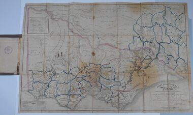 Bendigo Historical Society Inc.
Document - HARRIS COLLECTION: HAMS SQUATTING MAP OF VICTORIA, PORT PHILLIP DISTRICT, NSW
Thomas Ham was a cartographer, engraver, lithographer and publisher in Victoria and Queensland. He compiled and printed several editions of his squatting map, beginning with A map of Australia Felix in 1847 and changing its title to Ham's squatting map of Victoria in 1851. The 1851 edition was accompanied by a key listing the names of all the squatters within squatting districts and counties. Later editions show the existing counties, but some areas of Gippsland and the Australian Alps are still described as 'unsurveyed country'. (State Library Victoria https://www.slv.vic.gov.au/squatting-map-victoria)Folding map enclosed in burgundy cover. Map backed by cloth and bound. Rare, early map of Victoria and neighbouring Port Phillip District of New South Wales. Written on bottom RH corner of map: Ham's Squatting Map of Victoria ( Port Phillip District, New South Wales ) carefully corrected to this date from the Colonial Government Surveys, Crown Lands, Commissioners & Explorers Maps, Private Surveys & c. Respectfully inscribed (with permission ) to His Excellency Sir Chas A. Fitz-Roy Knt, Governor of New South Wales &c &c by his Obedient Servant, The Compiler, 1851. Compiled, engraved and published by Thomas Ham, Melbourne. Proposed and original boundary ( in legend) have been coloured in in blue and pink ink ( later addition ?) Number on map show 'reference to proprietor's Printed on back of map ' J.G. AD 1852, with two cross hatched decorations and two hearts entwined. On other back panel in pencil enclosed in a drawn frame ' G.S.H., 1889, Axedale' (George Harris, Axedale, belongs in Harris Collection) Stamped in purple ink 'Royal Historical Society of Victoria, Bendigo Branch. Written 1959, 53.map, victoria, squatting map -
Port Melbourne Historical & Preservation Society
Book, Amanda Scardamaglia, Printed on Stone, The Lithographs of Charles Troedel, 2020
The book is an account of the Charles TROEDEL & Co and their lithograph production. The author, Amanda SCARDAMAGLIA, mentioned the company in a footnote to her PhD thesis. From the interest came her first book 'From Stone to Print'. this book, 'Printed on Stone', covers the history of lithography as well as that of Charles, company from 1863 to 2013. In 1887 Edward COOPER joined the business & in 1890 he and Charles formed a partnership until the 1890's depression forced the temporary closure of the business in 1895. The book is lavishly illustrated with examples of the work.Hard cover book of 234 pages with its spine bound in red. Images on the pale yellow cover are two of Empire Dandelion Cocoa; one of Harper Oriental Coffee and one of R. Harper & Co's Pearl Rice .Presented to the Port Melbourne Historical Society August 2022 Amandabuilt environment - commercial, charles troedel, chas troedel & co, amanda scardamaglia, lithography, troedel & cooper -
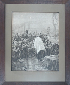 Mission to Seafarers Victoria
Print - Reproduction, Holy Communion on the battlefield (original painting title: Preserve Thy Body and Soul), c.1915
The original artwork painted by William Yates Holt Titcomb (1858-1930), an English artist specialist in religious subjects, is located in Clifton College Chapel, Bristol, England (visible in their virtual tour online). The original title draws on the Giving of Communion words: The body of our Lord Jesus Christ, which was given for you, preserve your body and soul unto everlasting life. Take and eat this in remembrance that Christ died for you, and feed on him in your heart by faith with thanksgiving. The blood of our Lord Jesus Christ, which was shed for you, preserve your body and soul unto everlasting life. Drink this in remembrance that Christ's blood was shed for you, and be thankful. The body of Christ. The blood of Christ. The body of Christ keep you in eternal life. The blood of Christ keep you in eternal life. The body of Christ, broken for you. The blood of Christ, shed for you. The bread of heaven in Christ Jesus. The cup of life in Christ Jesus.FigurativeReproduction ( Lithograph?) framed mounted and glazed print. The image shows a group of soldiers kneeling before a makeshift altar during World War One in Flanders field with a Red Cross flying on a flag pole at the far right of the composition. A Union Jack flag is being used as an improvised altar cloth. A priest or chaplain in a surplice, also a soldier , administers the sacrament to the reverent congregation. The print is glazed with a substantial window mount and housed in a dark wood frame with eyelet screws and very rusted hanging wire.Preserve Thy Body + Soulpainting, world war one, ww1, wwi, soldier, priest, altar, union jack, red cross, red cross flag, titcomb, andre sleigh and anglo ltd, clifton college, royal academy exhibition, 1915, preserve thy body and soul, reproduction print, the soldiers' communion, william yates holt titcomb (1858-1930), artwork-paintings