Showing 11595 items matching " map"
-
 Whitehorse Historical Society Inc.
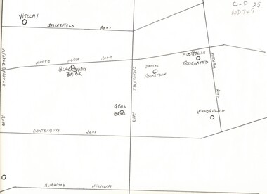
Map, Potteries, n.d
Sketch map of location of potteries in the area bounded by Middleborough, Springfield, Mitcham Roads and Burwood Highway.Sketch map of location of potteries in the area bounded by Middleborough, Springfield, Mitcham Roads and Burwood Highway.Sketch map of location of potteries in the area bounded by Middleborough, Springfield, Mitcham Roads and Burwood Highway.potteries, vitclay pipes pty ltd, blackburn brick and tile co., geal bros., wunderlich limited, australian tesselated tile co. pty ltd., daniel robertson australia pty ltd -
 Peterborough History Group
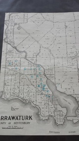
Map - Map of Curdies River Inlet district, Narrawaturk
Shows the allotment boundaries and names of landowners at the timeSignificant as it shows owners of rural land in the Peterborough area.Photocopy of an old mapHandwritten notes and markings on the map.peterborough, curdies river, curdies river inlet, old maps, maps, narrawaturk -
 Greensborough Historical Society
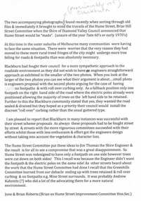
Folder, Hume Street Improvement Committee, 1958_
The Hume Street Improvement Committee was one of several 'progress associations' in the Greensborough area at the time the area was being urbanised. A typed page explains the concerns of residents when the street was being paved. Includes photographs and maps of area.These documents are concerned with the urbanisation of Greensborough in the mid 20th century while residents tried to maintain the rural feel of the area.Foolscap manilla folder containing various lists, maps and photographs.On cover "Hume Street Improvement Committee/ spare circulars/maps"greensborough, road making, brian roberts, hume street improvement committee, briar hill -
 Orbost & District Historical Society
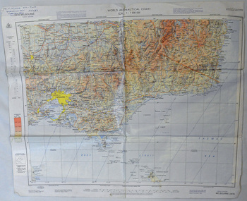
map, 1985
An aeronautical chart is a map designed to assist in navigation of aircraft. Using these charts and other tools, pilots are able to determine their position, safe altitude, best route to a destination, navigation aids along the way, alternative landing areas in case of an in-flight emergency, and other useful information such as radio frequencies and airspace boundaries. World aeronautical charts have a scale of 1:1,000,000 and cover relatively large areas. Orbost Aero Club began in 1969 with Basil Dowie as Chair, David Nixon as Secretary/Treasurer. The group went into recess from 1977-1991 closing in 1997. The mid 1960s were boom years in flying training in Australia and the number of Aero Clubs grew rapidly. The Club played a significant role in the establishment of the small airport at Marlo and in the ongoing operation and development of the airport over the years particularly for patient transfer by aerial ambulance. The Orbost Aero Club Club played a significant role in the establishment of the small airport at Marlo and in the ongoing operation and development of the airport over the years.A laminated map of eastern Victoria. A World Aeronautical Chart. It shows elevations, longitude etc and is designed for pre-flight planning as well as pilotage. Top left hand corner - D.F.N.Nixon VH-FWD 12 Kristine Ct Cheletenham 27/7/87orbost-aero-club aeronautical-map -
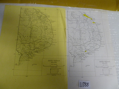 National Vietnam Veterans Museum (NVVM)
Map, 1983 (exact)
Two maps of South Vietnam dated 1954-1975. One on plain paper, one on yellow papermaps, south vietnam -
 Clunes Museum
Map
A MAP OF THE BOROUGH OF CLUNES. SCALE 20 CHAINS TO 1 INCH. MAIN HIGHWAYS NAMED. NO STREET NAMESdocument maps, borough of clunes map -
Whitehorse Historical Society Inc.
Map, Legislative Council - Electoral Provinces, 1991
State of Victoria. Legislative Council Electoral Provinces. Sheet 3 Metropolitan Map. 1990 - 1991 redivision.State of Victoria. Legislative Council Electoral Provinces. Sheet 3 Metropolitan Map. 1990 - 1991 redivision.State of Victoria. Legislative Council Electoral Provinces. Sheet 3 Metropolitan Map. 1990 - 1991 redivision.electoral boundaries, victoria. parliament. legislative council -
Whitehorse Historical Society Inc.
Map, Boroondara, Nunawading, 1853
Map of section of Parishes of Boroondara and NunawadingMap of section of Parishes of Boroondara and Nunawading with allotments numbered and named. Note on verso: Boroondara and Nunawading c1853.Map of section of Parishes of Boroondara and Nunawading maps, parish of nunawading, parish of boroondara -
Whitehorse Historical Society Inc.
Map, Shire of Blackburn and Mitcham, c1920
Hand drawn map of the Shire of Blackburn and MitchamHand drawn map of the Shire of Blackburn and Mitcham (Sheet 2) Scale 4 chains = 1 inchHand drawn map of the Shire of Blackburn and Mitchamshire of blackburn and mitcham, tunstall, nunawading, mitcham, maps -
Creswick Campus Historical Collection - University of Melbourne
Map, 1923
Creswick proposed extension, 25-5-1923.Cloth map -
 Ballarat Tramway Museum
Postcard, H&B, Lake Wendouree within an embossed map Australia, 1910's?
Postcard - with a view of Lake Wendouree within an embossed map Australia - no Tasmania. Coat of arms also embossed. Has words "Lake Wendouree Ballarat" within photograph. In top left hand corner, has Australian Coat of Arms, partially embossed, printed in blue with words "Greetings from Australia". See also Reg Item 4004 for a similar card and written originally by the same person. On rear, the post card has been divided into two with a the words "Commonwealth of Australia and Post Card" and artistic symbol with the initials "H&B". Early Commonwealth of Australia postcard, after the Post Master General's department formed late 1900's. See also Reg item 4004.Printed coloured / black and white postcard. On rear in ink " Happy New Year, from Ern & Lucy, children to Esther" ????trams, tramways, lake wendouree, postcards -
 Federation University Historical Collection
Map - Geological, Tallangatta, New South Wales: 1:250,000 Geological Series, SJ 55-3, 1966, 1966
Compiled by the Geological Survey of N.S.W., Division of Regional Geology. Topographical base compiled from Snowy Mountains Hydro Electrical Authority, Department of Lands, County maps and Snowy Lease Map. Other sheet adjoin this map. There are 13 formation sections grouped into 9 - Quaternary, Tertiary, Middle Devonian, Lower to Middle Devonian, Lower Devonian, Upper Silurian, Silurian, Upper Ordovician and Ordovician.Large coloured map showing geological features, faults, bores, rivers and mineral deposits.Scale of map, longitude and latitude, river names. "Tallangatta 1:250,00" written in black pen.tallangatta, new south wales, geological survey, topographical base, snowy mountains hydro electrical authority, department of lands, snowy lease map, department of mines, quaternary, tertiary, middle devonian, lower to middle devonian, lower devonian, uper siluran, silurian, upper ordovician, ordovician -
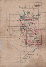 Tarnagulla History Archive
Linen-Backed Map of Poseidon Goldfield, c1915, with Mining Leases and Shaft locations
This is a very nice foolscap-size map, probably prepared by a Mines Department or other Government surveyor with the intention of assisting to attract mining capital to the goldfield. The red sketched-in deep lead positions are inaccurate. The pencil notation upper left reads "Lowther's Lease 6415". Lowther was a Tarnagulla mining promoter of the time. The Tarnagulla Racecourse location is marked as is the Woolshed Reef State School. -
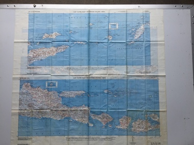
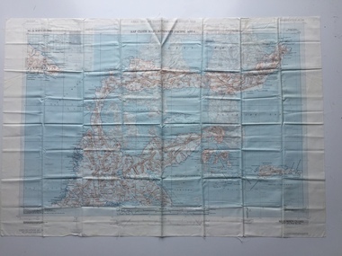 B-24 Liberator Memorial Restoration Australia Inc
Map - US World War II multi-coloured map- Southwest Pacific Area, No. 23 North Celebes, No. 24 South Celebes, 1942-1943
Silk and rayon maps were produced by the United States (c. 7.5 million in total), Great Britain (some 1.75 million in total) and Australia during World War II. They were issued to Allied military personnel as part of 'escape and evasion' kits.This map, printed on acetate rayon, is an original US 'escape and evasion' kit map from World War II.A multi-coloured, contoured, double-sided map printed on acetate rayon AAF Cloth Map - Southwest Pacific Area Side 1 - No. 23 North Celebes Side 2 - No. 24 South Celebesworld war ii, silk maps, united states of america, a189 -
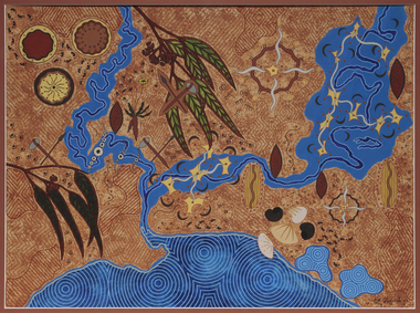 Merri-bek City Council
Acrylic on watercolour paper, Mandy Nicholson, Cultural Map of Melbourne, 2003
Primarily a painter, Mandy Nicholson also produces ceramics, carvings, murals, prints, designs and children’s clothing. Born in 1975, Nicholson was raised in Healesville and belongs to the Wurundjeri-willam (Woiwurrung language) clan of the Kulin Nation. Mandy’s paintings often represent important cultural rituals and are executed in her distinct graphic style using the traditional motifs of her people blended with contemporary interpretation. Cultural Map of Melbourne shows significant sites across Melbourne. These include scar trees, corroboree trees, stone quarries, bush tucker sites, significant rivers, fresh water wells and traditional campsites. -
Whitehorse Historical Society Inc.
Map, Pocket guide to walking and wheeling in Whitehorse, 2008
Map showing walks, cycle tracks and off lead areas for dogs in Whitehorse.Map showing walks, cycle tracks and off lead areas for dogs in Whitehorse. Includes walking and cycling groups.Map showing walks, cycle tracks and off lead areas for dogs in Whitehorse. walking trails, bicycle paths, city of whitehorse -
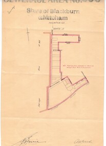 Whitehorse Historical Society Inc.
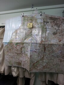
Map, Sewerage area No 966, 1/06/1933 12:00:00 AM
Map of sewerage are no. 965 covering part of North Blackburn.Map of sewerage are no. 965 covering part of North Blackburn. Note that Stuart Street is now part of Thiele Court. Map of sewerage are no. 965 covering part of North Blackburn. middleborough road, blackburn, sergeant street, stuart street, thiele court, blackburn north, attunga street, walker, a. w., borrie, e., shire of blackburn and mitcham, sewerage and sanitation -
Clunes Museum
Map, DEPARTMENT OF LANDS AND SURVEY, TOWNSHIP OF CLUNES, PARISH OF CLUNES, COUNTY OF TALBOT, 1950
MAP OF CLUNES ON PAPER SHOWING HOTELS AND TOWNSHIP HIGHLIGHTS COMPLETE WITH LEGEND. OVERWRITTEN NOTATIONS IN RED AND BLUE INKPRICE 2stownship of clunes 1950, hotels of clunes -
Whitehorse Historical Society Inc.
Map, Waverley, c1985
Map of Waverley, including Box Hill Soiuth, Blackburn South, Vermont, Vermont South, Burwood East, Burwood, Ashburton, Mount Waverley, Glen Waverley, Oakleigh South, Clayton North and Mulgrave.Map of Waverley, including Box Hill Soiuth, Blackburn South, Vermont, Vermont South, Burwood East, Burwood, Ashburton, Mount Waverley, Glen Waverley, Oakleigh South, Clayton North and Mulgrave. UBD map issued by Nicholls Gledhill Real Estate Agents. Scale 1:50,000.Map of Waverley, including Box Hill Soiuth, Blackburn South, Vermont, Vermont South, Burwood East, Burwood, Ashburton, Mount Waverley, Glen Waverley, Oakleigh South, Clayton North and Mulgrave. blackburn south, burwood east, vermont, vermont south, forest hill -
Clunes Museum
Map, 1962
.1 &.2 MAP OF BALLARAT SHIRE GROUP RURAL FIRE BRIGADES FIRE CONTROL MAP. COMPILED BY C. H. FENTON. (2 COPIES) DETAILING SEALED ROADS, STATE FORESTS, PINE PLANTATIONS, FOREST AREAS, RAILWAYS, BOUNDARIES, TOWNSHIP AREAS CEMETERIES, CREEKS, SWAMPS AND HOUSES.local history, document, maps, fire brigade -
Whitehorse Historical Society Inc.
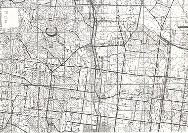
Map, Aerial maps, 2/04/1966 12:00:00 AM
Melbourne 1966 project, runs 10A and 11A, lens 122 151.75 mm 9,800. Photo nos 77, 107, 109, 161, 163, 165.Melbourne 1966 project, runs 10A and 11A, lens 122 151.75 mm 9,800. Photo nos 77, 107, 109, 161, 163, 165. Areas and boundaries: Map no 77 W. Park and Cook Roads; E. Dubon Rd; N Oban Rd; S Reilly St. Map No 107. W. Indra Rd and Pakenham St; E. Rooks Rd & McLares Rd; N. Maroondah Hwy; S. Hawthorn Rd & Eley Rd. Map No 109 W. Elgar Rd. E. Blackburn Rd & McKean St; S. Eley Rd & Burwood Hwy. Map No 161. W. Elgar Rd & Huntingdale Rd; E. Blackburn Rd; N. Burwood Hwy; S. Waverley Rd. Map No 163. W. Blackburn Rd; S. Springvale Rd; N. Eley Rd & Hawthorn Rd; S. Glen Waverley Railway Line. Map No 165. W. Stanley Rd, Vermont South; E. Cathies Lane, Wantirna South; N. North of Burwood Hwy; S. High Street. Melbourne 1966 project, runs 10A and 11A, lens 122 151.75 mm 9,800. Photo nos 77, 107, 109, 161, 163, 165. aerial photographs, blackburn, blackburn south, forest hill, nunawading, box hill, burwood, burwood east, donvale, mount waverley, glen waverley, wantirna, vermont south, mitcham, ringwood north, ringwood -
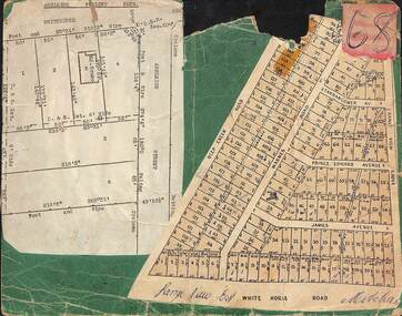 Ringwood and District Historical Society
Card, Collage of Residential Subdivision Map Clippings - Ashleigh Poultry Farm, Blackburn, Vic and Range View East, Mitcham, Vic. (Undated, circa 1930s)
Weekly Times (Melbourne, Vic.) Sat 24 Aug 1935 Page 6 - 1800 Chickens Burnt. Starting in the incubator room, a fire at the Ashleigh Poultry Farm, Whitehorse Road Blackburn, early on August 20, incinerated 1800 young chickens and 1000 eggs. The incubator room and the chicken pens were reduced to ashes, but a large drum of kerosene standing in the room was undamaged! The owners of the farm, Mrs N. Foote and her sons, have suffered a severe setback, as practically all their chickens and eggs are gone, and it is too late to start hatching again this season.Two maps mounted on green cardboard. 1. Ashleigh Poultry Farm - Layout of weatherboard house and six residential allotments on Whitehorse Road and Ashleigh Street (later Ashburn Place), Blackburn, Victoria. 2. 140 allotments with frontages on Deep Creek Road, Warnes Road, Range View Grove, Tarrangower Avenue, Prince Edward Avenue, James Avenue and White Horse Road, Mitcham, Victoria. -
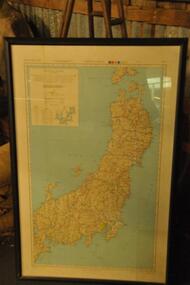
 B-24 Liberator Memorial Restoration Australia Inc
Map - US World War II-coloured map, - Southwest Pacific Area, No.22 Southwestern, No.26 East Java, No.25 Timor, 1943
Silk and rayon maps were produced by the United States (c. 7.5 million in total), Great Britain (some 1.75 million in total) and Australia during World War II. They were issued to Allied military personnel as part of 'escape and evasion' kits.This map, printed on acetate rayon, is an original US 'escape and evasion' kit map from World War II.A multi-coloured, contoured, double-sided map printed on acetate rayon AAF Cloth Map - Southwest Pacific Area Side 1 - No. 22 Southwestern and No. 26 East Java Side 2 - No. 25 Timorworld war ii, silk maps, united states of america, a188 -
 Greensborough Historical Society
Map, Keelbundora. Counties of Bourke and Evelyn, 1950_11
Covers area bounded by Merri Creek, Yarra River, Plenty River and Crown Portions 24 to 28, with section including Maroondah Aqueduct and Darebin Creek.Photocopy of digitised mapkeelbundora (parish) -
 Running Rabbits Military Museum operated by the Upwey Belgrave RSL Sub Branch
Map
Map of Inner Japanuniform, army -
 Running Rabbits Military Museum operated by the Upwey Belgrave RSL Sub Branch
Map
Map Malaysia 1150maps, 2002, army -
Hand Tool Preservation Association of Australia Inc
Map
This item is part of the Thomas Caine Tool Collection, owned by The National Trust of Australia (Victoria) and curated by the Hand Tools Preservation Association of Australia.Map of gippsland lakes -
Clunes Museum
Map
Photocopy of map Underground Survey of mines at Clunes Clunes Goldfields Co. (two sheets joined) Port Phillip Co.Nilcartography, clunes mines, clunes goldfield co. -
Whitehorse Historical Society Inc.
Map, Shire of Blackburn and Mitcham, c1920
Map of the Shire of Blackburn and Mitcham (Sheet 2) with gas and sewered areas coloured.Map of the Shire of Blackburn and Mitcham (Sheet 2) with gas and sewered areas coloured. Scale 8 chains = 1 inch.Map of the Shire of Blackburn and Mitcham (Sheet 2) with gas and sewered areas coloured.shire of blackburn and mitcham, sewerage and sanitation, gas supply -
 Whitehorse Historical Society Inc.
Map, Orchards 1922, 1922
1922 map showing orchards in Doncaster East, Blackburn, Mitcham, Tunstall, Ringwood, Vermont, East Burwood, Tally Ho.vermont orchards, tunstall, ringwood, blackburn, tally ho, east doncaster