Showing 9983 items
matching sections
-
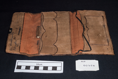 City of Moorabbin Historical Society (Operating the Box Cottage Museum)
Personal Effects, lady's leather wallet, 20thC
A lady's brown soft leather wallet with 3 sections and a brass clasp A.C.I ENNIS WITH COMPLIMENTS FROM / JAMES LYONS LTD / SAWMILLERS & TIMBER MERCHANTS / CAIRNS N.Q.moorabbin, brighton, early settlers, pioneers, cheltenham, craftwork, leather, wallets, purses -
 Port Melbourne Historical & Preservation Society
Plan - Walter Avenue, Port Melbourne, Town of Port Melbourne, 1893 - 1919
Plan of Walter Avenue showing various cross sections, date unknown.engineering - roads streets lanes and footpaths, walter avenue, loans program -
Port Melbourne Historical & Preservation Society
Plan - Rouse Street footbridge, Borough of Sandridge, 6 Oct 1877
Elevation, ground plan and traverse section of Rouse Street footbridge. 1877.Samuel Carter (?) 6/10/1877. Edward Clark (Town Clerk) 6/10/1877.engineering - bridges, sandridge lagoon, edward clark, town clerks -
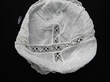 Churchill Island Heritage Farm
Clothing - Mob Cap, Budoir
A mob cap was worn over the hair when indoors working and a hat could be placed over it when going outdoors. It was quite reasonable to receive visitors while wearing a mob cap. This cap has been labelled as a ‘boudoir’ cap to be worn over curlers or to keep a lady’s hair in place overnight. It is made of cotton and has beautiful torchon lace inserts with the same lace trim around the edge. This torchon lace is a handmade bobbin lace using soft cotton thread.in a simple design of filled diamonds alternating with spiders. These caps were worn by women in Georgian times and called a ‘bonnet’. The term ‘mobcap’ may have come from the Dutch or French languages but the name was cemented during the French Revolution when most of the revolutionary women were wearing these caps. During the Victorian era they were mostly worn by servants or nurses.Churchill Island has a large lace collection, which was added to by three successive generations of the Amess family - Jane, Janet, and Unity. The Amess family owned Churchill Island from 1872 to 1929. Jane was wife of Samuel Amess, who was the first Samuel Amess to own Churchill Island. The examples of lace are notable for their variety, and provide respresentative examples of techniques from the late nineteenth to the early twentieth centuries. white cotton mob cap, with central lace section in the form of a crossPackaged with note: "White cotton handmade lace mob cap"lace, lace collection, churchill island -
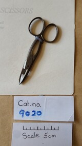 Coal Creek Community Park & Museum
Button hole scissors
Belonged to Miss Elizabeth Bull, born in 1851, who came to Australia with her parents R & L Bull and settled in Bairnsdale, in Eastern Victoria in the 1860s. Donated by Mrs A. S. Fulton of 21 Waterloo St Camberwell, Victoria on 5th September 1986.Metal button home scissors with square cut section in top blade. -
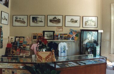 Churchill Island Heritage Farm
Photograph - Photograph of Churchill Island Shop
Churchill Island Heritage Farm has a large photographic collection dating from the nineteenth century. This series shows more contemporary photographs taken from around Churchill Island.Photograph of section of the Churchill Island Souvenir Shop showing a number of displayscatalogue number written on reverse in pencilphotograph, churchill island -
 Bendigo Historical Society Inc.
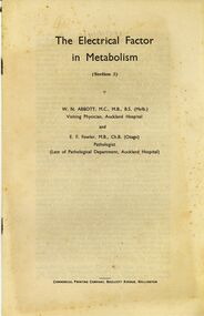
Document - BILL ASHMAN COLLECTION: THE ELECTRICAL FACTOR IN METABOLISM (SECTION 2)
Nineteen copies of a booklet titled The Electrical Factor in Metabolism (Section 2)W.N.Abbott & E.F.Fowlersciences, general, scalebuoy -
 Bendigo Historical Society Inc.
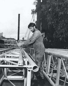
Photograph - AUSTIN COLLECTION: MINER WORKING ON NEW LIFT
Black and white photograph of Paul Maher working on a section of the lift mast.mining, business, central deborah gold mine -
Bendigo Historical Society Inc.
Tool - INDIGENOUS STONE TOOL COLLECTION: GRINDING STONE
Brown stone grinding tool which formed the top section, the 'muller'. -
Moorabbin Air Museum
Book (item), Jet Propulsion and Gas Turbines, 1948
Owned by Paul Straney, purchased in Sydney. -
Moorabbin Air Museum
Manual (item) - GAF Drawing Office Manual Volume; Bob Nash; Specifications; General; Bolts; Clips; Design; Drills; Electrical; Grommets; Injection Moulding; Knobs; Fasteners; Nuts; Materials; Lofting; Limits; Pins; Screws; Rivets; Pipes; Washers
-
 Buninyong & District Historical Society
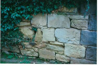
Photograph - Original Photograph, C J Brooks, Section of sandstone wall, 405 Learmonth St. Buninyong, July 1995
Stone of which wall is constructed is believed to have been used in the construction of Jamieson's Buninyong Inn, built for Margaret Jamieson starting about 1853. She owned the earlier Buninyong Inn which impinged on they surveyed Learmonth St. and was demolished. Margaret died in 1854 before the building was completed by her son, who built the third Buninyong Inn on the corner of Learmonth and Warrenheip. The two story hotel was tenented for a while, then bought by Dr. Sparling who demolished it.Colour photo, Section of sandstone wall, 405 Learmonth St. Buninyong.buninyong, jamieson, sparling, buninyong inn, wall, sandstone -
Tatura Irrigation & Wartime Camps Museum
Recorder, 1940's
Made by Internees at Camp 3, Tatura. The material was selected from firewood. Erich Bulach tuned the recorder to a perfect pitchHandmade wooden section (mouthpiece) of a recorder. End has been pluggedrecorder, frank r, doster h, vollmet h, camp 3, tatura, ww2 camp 3, musical, instruments, wind -
Tatura Irrigation & Wartime Camps Museum
Sports program, c1940
Program for sports held at camp 3 Tatura during WW2 by InterneesSports program, typewritten and duplicated with sections handwritten in ink of individual informationsport, camp 3, kazenwadel, gerda, decker, tatura, documents, programmes -
Creswick Campus Historical Collection - University of Melbourne
Education kit - 3D Model - Leaf Structure, Biocalderoni KFT, Leaf Structure model
Plastic and foam model of the cross section of a beech leaf. Fagus silvatica -
Stawell Historical Society Inc
Map, Underground Survey of the Principal Mines of Stawell 1879, 1879
Pleasant Creek & Newington, Prince Patrick, Prince Alfred, Pioneer and Galatea, Pleasant Creek Cross Reef No. 1&2, Magdala, Old Shaft, Extended Cross Reef, Crown Cross, Great Northern, Sloanes & Scotchmans, South Cross, 10 & 11 United Scotchmans South Cross, Scotchmans Shafts, North Scothmans, West Scotchmans, Emerald Isle & Rose of Denmark, Albion, South Scotchmans, Newington & Pleasant Creek, Pleasant Creek Cross Reef, Moonlight, Extended Cross Reef, Crown cross United, Great Northern ShaftVery large Map on cloth backing, showing cross sections of mines.Surveyed by H.C. Bates. Drawn by Arthur Edwards. October 30th 1879. Scales 120 feet to an inchmining, gold -
Koorie Heritage Trust
Booklet, Public Records Office Victoria, Finding your story : A resource manual to the records of the Stolen Generations in Victoria, 2005
"Finding Your Story" provides a comprehensive and cohesive resource of government and non-government record and archival collections in Victoria relevant to the Stolen Generations and their families.120 P; 16 sections; ports.; refs.; index; 32 cm."Finding Your Story" provides a comprehensive and cohesive resource of government and non-government record and archival collections in Victoria relevant to the Stolen Generations and their families.aboriginal australians -- victoria -- archives. | children, aboriginal australian -- government policy -- victoria -- archives. | victoria -- archival resources. -
 Whitehorse Historical Society Inc.
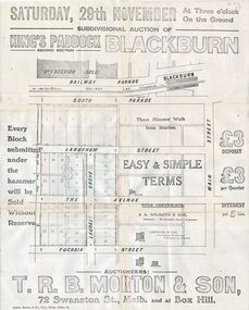
Document, Kings Padddock Blackburn
Plan showing land for sale at Kings PaddockPlan showing land for sale at Kings Paddock, Blackburn (second section).Plan showing land for sale at Kings Paddockauctions, kings paddock, blackburn, south parade, laburnum street, the avenue, fuchsia street, laurel grove, main street, t.r.b. morton & son -
Lakes Entrance Regional Historical Society (operating as Lakes Entrance History Centre & Museum)
Photograph, Judy Davies, 2010
Colour photograph of monumental section of Bumberrah Cemetery near Johnsonville Victoriacemeteries, water supply -
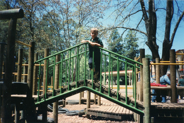 Mt Dandenong & District Historical Society Inc.
Photograph, Mount Dandenong Primary School 1997, 1997
Miss Bell (1900 – 1984) The ‘Miss Bell Playground’ was named after Miss Rebecca Adelaide Bell, a retired teacher who regularly helped out at Mt Dandenong Primary school for 8 years. Born in NSW, Miss Bell had taught in several states and had fond memories of holidays spent at ‘Mountjoy’ in the Dandenong Ranges. When she retired Miss Bell built a home in Jeeves Avenue where she lived out the rest of her life with her Siamese cats. Miss Bell helped the children with reading, grammar spelling and history. She really cared about the children and her school visits brought her a lot of happiness. Student standing on section of play equipment in Miss Bell Playground 1997.mount dandenong, mt dandenong school, miss bell, rebecca adelaide bell, school, playground -
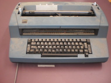 Wangaratta High School
Electric Typewriter
IBM Electric typewriter Blue body with black keyboard and interior sectionsIBM -
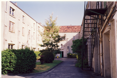
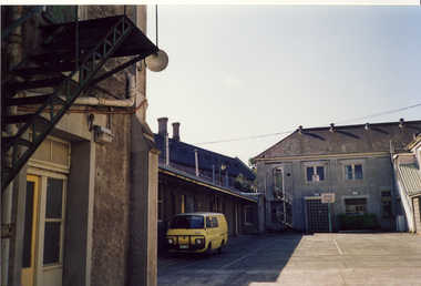
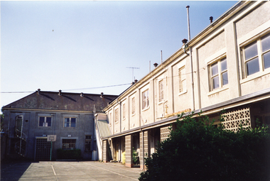
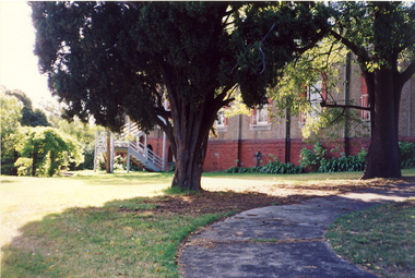 Kew Historical Society Inc
Photograph, Former Convent of the Good Shepherd, Abbotsford, c.1990
The former Convent of the Good Shepherd at Abbotsford includes ecclesiastical, residential, educational and utility buildings constructed during the late nineteenth and twentieth centuries on a bend of the Yarra River. In 1975 the site was purchased by the Victorian Government as a higher education campus. A proposed redevelopment of the site in the late 1990s led to a community-based heritage battle which resulted in 2004 in the transfer of the convent site south of St Heliers Street to the Abbotsford Convent Foundation for community use. (Source: Heritage Victoria)This photograph is part of a series taken c.1990 by the photographer Rick Lowell. It was taken before the heritage campaign to preserve the site for community use.Colour snapshot of a part or section of the Former Convent of the Good Shepherd, Abbotsfordconvent of the good shepherd, abbotsford -
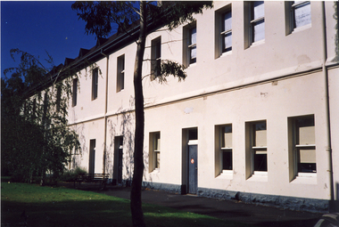
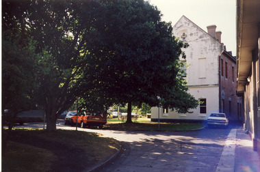 Kew Historical Society Inc
Photograph, Former Convent of the Good Shepherd, Abbotsford, c.1990
The former Convent of the Good Shepherd at Abbotsford includes ecclesiastical, residential, educational and utility buildings constructed during the late nineteenth and twentieth centuries on a bend of the Yarra River. In 1975 the site was purchased by the Victorian Government as a higher education campus. A proposed redevelopment of the site in the late 1990s led to a community-based heritage battle which resulted in 2004 in the transfer of the convent site south of St Heliers Street to the Abbotsford Convent Foundation for community use. (Source: Heritage Victoria)This photograph is part of a series taken c.1990 by the photographer Rick Lowell. It was taken before the heritage campaign to preserve the site for community use.Colour snapshot of a part or section of the Former Convent of the Good Shepherd, Abbotsfordabbotsford convent -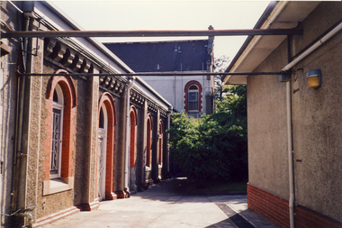
 Kew Historical Society Inc
Photograph, Former Convent of the Good Shepherd, Abbotsford, c.1990
The former Convent of the Good Shepherd at Abbotsford includes ecclesiastical, residential, educational and utility buildings constructed during the late nineteenth and twentieth centuries on a bend of the Yarra River. In 1975 the site was purchased by the Victorian Government as a higher education campus. A proposed redevelopment of the site in the late 1990s led to a community-based heritage battle which resulted in 2004 in the transfer of the convent site south of St Heliers Street to the Abbotsford Convent Foundation for community use. (Source: Heritage Victoria)This photograph is part of a series taken c.1990 by the photographer Rick Lowell. It was taken before the heritage campaign to preserve the site for community use.Colour snapshot of a part or section of the Former Convent of the Good Shepherd, Abbotsfordabbotsford convent, convent of the good shepherd, abbotsford (vic.) -
 Kew Historical Society Inc
Photograph, Former Convent of the Good Shepherd, Abbotsford, c.1990
The former Convent of the Good Shepherd at Abbotsford includes ecclesiastical, residential, educational and utility buildings constructed during the late nineteenth and twentieth centuries on a bend of the Yarra River. In 1975 the site was purchased by the Victorian Government as a higher education campus. A proposed redevelopment of the site in the late 1990s led to a community-based heritage battle which resulted in 2004 in the transfer of the convent site south of St Heliers Street to the Abbotsford Convent Foundation for community use. (Source: Heritage Victoria)This photograph is part of a series taken c.1990 by the photographer Rick Lowell. It was taken before the heritage campaign to preserve the site for community use.Colour snapshot of a part or section of the Former Convent of the Good Shepherd, Abbotsfordabbotsford convent, convent of the good shepherd, abbotsford (vic.)