Showing 2472 items matching " township"
-
 Mt Dandenong & District Historical Society Inc.
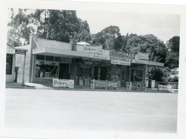
Photograph, Southall's Newsagency Olinda, late 1920s
Small photograph from the Olinda township showing view of Southall's Newsagency with milkbar and confectionary. There are many old advertising signs clearly visible. The road is not yet made so this would place the date around the late 1920s.southalls, olinda, newsagency, milkbar -
 The 5th/6th Battalion Royal Victoria Regiment Historical Collection
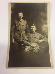
Souvenir - Photographs and Post Cards, 1916-1918
cameras were not common during the first world war. as such post cards of portraits and the damage of the battlefield were common.Collection of black and white post cards and photographs. 20 post cards are of the township of Villers Brettoneux after the German shelling. 2 are of Australian Soldiers. One of the photos is written on, otherwise the post cards are unmarked and in good condition." Stanley and I taken in London August 1916.ww1, souvineer, post card, wark vc club -
 National Vietnam Veterans Museum (NVVM)
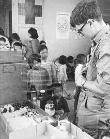
Photograph, Gibbons, Denis, Medcap
Denis Gibbons (1937 – 2011) Trained with the Australian Army, before travelling to Vietnam in January 1966, Denis stayed with the 1st Australian Task Force in Nui Dat working as a photographer. For almost five years Gibbons toured with nine Australian infantry battalions, posting compelling war images from within many combat zones before being flown out in late November 1970 after sustaining injuries. The images held within the National Vietnam Veterans Museum make up the Gibbons Collection. A black and white photograph of a medic attached to 161 (Indep) Recce Flt administers vitamin pills to children during a Medcap conducted at Xuyen Moc after the township had been cleared of VietCong forces by 5 RAR. photograph, 161 reconnaissance flight, xuyen moc, 5 rar, gibbons collection catalogue, medic, viet cong, vietnamese children, denis gibbons -
 Lakes Entrance Historical Society
Book, Bates Bob, Lucy Stonebridge, 2003
A sympathetic account of the life of Lucy Strobridge a woman who lived in isolation in the bush in the old Brookville mining area, Swifts Creek being the closest permanent township. The author gives an account of Lucy's family history, and the history ofsettlers, mines and mining, genealogy -
 Bendigo Historical Society Inc.
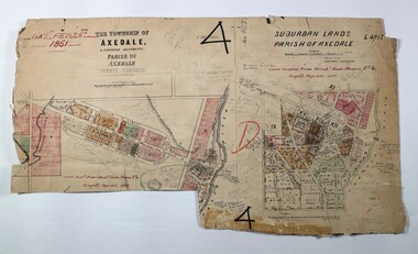
Map - LOCAL AREA PLANS, See above
Map: Compilation of maps: Town lots Bridgewater dated April 29 1871. Village of Colbinnabbin, dated 5 December 1866, Township of Axedale 1858 (Larritt). Suburban lands Axedale dated April 12 1871map, bendigo, parish plan, bridgewater, colbinnabbin, axedale, suburban lands -
 Clunes Museum
Photograph, KODAK, 1999
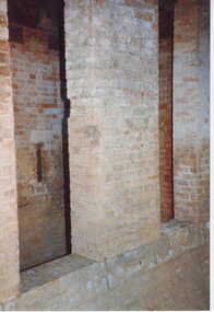
VIEW OF POWDER MAGAZINE USED IN MINING DAYS TO STORE EXPLOSIVES. BUILDING MATERIALS SOLID BRICKCOLOURED PRINT PHOTOGRAPH OF POWDER MAGAZINE INTERIOR. SITUATED IN A PADDOCK ON SMEATON ROAD APPROX. 2 KM. FROM TOWNSHIP ON LEFT HAND SIDE. SMALL WINDOW IN LEFT HAND WALL SOLID STEP LEADING TO RECESS.local history, photography, mining, powder magazine -
 Sunbury Family History and Heritage Society Inc.
Photograph, Bulla P, 1988
The photograph was taken from the west side of Bulla Hill near Loemans Road, which is west of the township of Bulla. The rocks outlining the name of the town were a landmark when approaching the township along the Sunbury Road on the west side of the town. They remained there until the school was closed in 1996 and the new owner removed them.A coloured photograph of Bulla Primary School with the word 'Bulla' formed from rocks on the distant hillside. schools, bulla primary school -
![Map, Plan of Subdivision of Crown Portion 23 & parts 24-25, Parish of Korkuperrimul [1900s?]](/media/collectors/5e461d8021ea67224c82f2a1/items/675fe058304668462205d4fb/item-media/675fe0ef304668462205d7d6/item-fit-380x285.jpg) Bacchus Marsh & District Historical Society
Bacchus Marsh & District Historical SocietyMap, Plan of Subdivision of Crown Portion 23 & parts 24-25, Parish of Korkuperrimul [1900s?]
The Parish of Korkuperrimul includes a significant section of the township of Bacchus Marsh and extends in western and northern directions from the township area. The date of the subdivision indicated on this plan has not been established. The engineer's stamp on the drawing shows the firm of Muntz and Muntz who were operating under that name in the early part of the 20th century.A single page paper map showing 20 blocks of land for sale in the Parish of Korkuperrimul. Scale 100 feet to 1 inch. The map is pasted into a bound volume containing 76 maps or plans in total. High resolution digital image stored on BMDHS computer network. Stamped: 'Muntz & Muntz Civil Engineers, Architects & Surveyors, Trustees Chambers ?? Cor Collins Street and Bank Placeland sales bacchus marsh, bacchus marsh victoria maps, land sales korkuperrimul parish -
 Greensborough Historical Society
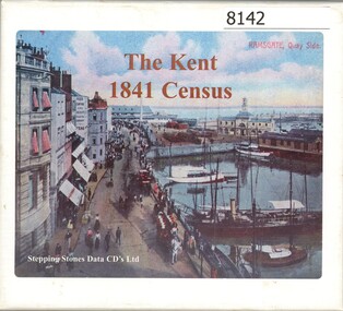
CD-ROM, Stepping Stones Data CDs Limited, The Kent 1841 census, 1841
CD set contains the 1841 census for Kent in Great Britain. It is searchable by Parish, township and hamlet. May assist in family history research.3 x CD-ROMs , contents note and instructions for use in boxcensuses great britain, kent england, family history -
 Koroit & District Historical Society
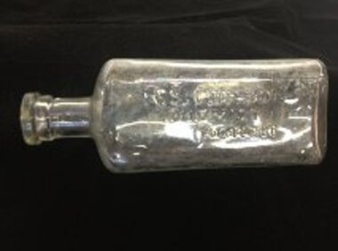
bottle, R S Corson Chemist Koroit, 1920s
R S Corson was a chemist in Koroit in the 1920s. This bottle was unearthed in a garden in the nearby township of Kirkstall.The bottle is an example of the type of bottle used by a chemist at this time.clear glass pharmacy bottle that would have held a liquid.the name "R S CORSON/CHEMIST/KOROIT" is moulded into the glass.chemist, corson, bottle -
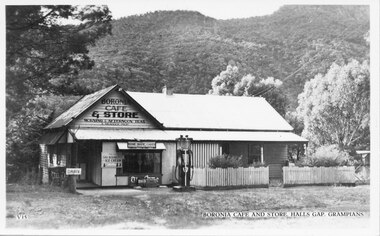 Halls Gap & Grampians Historical Society
Postcard - B/W, C 1930s
The picture is of Boronia Cafe and Store, which was situated one kilometre south of Halls Gap township.The postcard shows a building with a sign reading "Boronia Cafe & Store". The building has a picket fence at the front and a canvas awning on part of its verandah. There is a petrol pump at the front of the building and wooded hills behind.buildings, shops -
 Eltham District Historical Society Inc
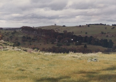
Photograph, Balaclava Open Cut Mine near Whroo Historic Reserve; 9 Oct 1994, 20/11/1994
Whroo Historic Reserve contains a number of interesting features relating to the former township and gold workings.Record of the Society's history of activities - Spring 1994 excursionRoll of 35mm colour negative film, 4 stripsKodak Gold 100-4shire of eltham historical society, activities, whroo, balaclava hill, balaclava mine, gold mining, whroo historic reserve -
 Eltham District Historical Society Inc
Photograph, Whroo Historical Area; 9 Oct 1994, 20/11/1994
Whroo Historic Reserve contains a number of interesting features relating to the former township and gold workings.Record of the Society's history of activities - Spring 1994 excursionRoll of 35mm colour negative film, 4 stripsKodak Gold 100-4shire of eltham historical society, activities, whroo, balaclava hill, balaclava mine, gold mining, whroo historic reserve -
 Eltham District Historical Society Inc
Photograph, Balaclava Open Cut Mine near Whroo Historic Reserve; 9 Oct 1994, 20/11/1994
Whroo Historic Reserve contains a number of interesting features relating to the former township and gold workings.Record of the Society's history of activities - Spring 1994 excursionRoll of 35mm colour negative film, 4 stripsKodak Gold 100-4shire of eltham historical society, activities, whroo, balaclava hill, balaclava mine, gold mining, whroo historic reserve -
 Eltham District Historical Society Inc
Photograph, Whroo Historical Area; 9 Oct 1994, 20/11/1994
Whroo Historic Reserve contains a number of interesting features relating to the former township and gold workings.Record of the Society's history of activities - Spring 1994 excursionRoll of 35mm colour negative film, 4 stripsKodak Gold 100-4shire of eltham historical society, activities, whroo, balaclava hill, balaclava mine, gold mining, whroo historic reserve -
Clunes Museum
Photograph - PHOTOGRAPHS - SLIDES
FORTY FOUR SLIDE COLLECTION OF CLUNES TOWNSHIP DONATED TO CLUNES MUSEUM BY MR. G. HATHEALLCOLLECTION 44 PHOTOGRAPHIC SLIDES OF CLUNESlocal history, photography, photographs, slides, clunes township, mining, sawmill -
Stawell Historical Society Inc
Book - History, Phil Waring, A History of the Pubs & Publicans of Landsborough 1862 - 2000, Author Phil Waring, 2023
This publication relates specifically to the Hotels in the township of Landsborough and in Landsborough Vallet from the Malakoff to Glenisters Gap.Light Green A4 Book with colour photograph of Landsborough Hotel on CoverAuthor Phil Waringhotels -
 Federation University Historical Collection
Document, Declaration of Ernest by owners of land in Yendon being held as a site for Public Hall and Free Library; 1891, 1891
Document outlining the agreement between five males, all residents of Yendon. Land that had been purchased - being part of Crown Allotment Five Section six, Township of Buninyong East, Parish of Buninyong, County of Grant, has been purchased "as a site for a public hall and free library for the use and benefit of the inhabitants of the Township of Yendon."Thick paper, hand written. Red dots indicate places for signatures Document stamped in green - 0122083 Signatures of; John Winterburn Kemp, Philip Ballantyne, Samuel Henry Mayo, Thomas Dooley, Thomas Watsondeclaration of ernest, land title, free library, public hall, yendon, buninyong, paris of buninyong, county of grant, john winterburn kemp, philip ballantyne, samuel henry mayo, thomas dooley, thomas watson -
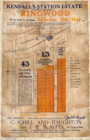 Ringwood and District Historical Society
Flyer, Auction Sale Advertisements - Kendall's Station Estate, Ringwood, Victoria - 1914
Advertisements for auction sale on Saturday, 9th May (1914) 43 township and villa allotments directly opposite the railway station, showing terms of sale and subdivision layout. Un-named newspaper clipping advertising this auction also attached.Subdivision includes James Street and William Street (later Kendall Street), Ringwood. Agents in conjunction - Coghill & Haughton and J.B. McAlpin. Sale by order of Mrs. E. Kendall. -
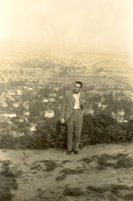 Federation University Historical Collection
Photograph, Frank Wright on Beacon Hill, Great Malvern, 1934, 05/07/1934
Frank Wright was a renown resident of Smeaton, where he was born. He lived at Laura Villa, and attended Smeaton State School. His father William was a gold miner and his mother's name was Sarah. Their family won many singing and instrumental awards. Frank was tutored by Percy Code and was awarded a gold medal for the highest marks in the ALCM examinations in the British Colonies at the age of seventeen years. He became the Australian Open Cornet Champion by the age of eighteen. A year later, Frank conducted the City of Ballarat Band, and later the Ballarat Soldiers’ Memorial Band. He formed the Frank Wright Frisco Band and Frank Wright and his Coliseum Orchestra. These bands won many South Street awards, and Frank as conductor won many awards in the Australian Band Championship contest. In 1933 Frank Wright sailed to England to conduct the famous St Hilda’s Band and was later appointed Musical Director of the London County Council, where he organized many amazing concerts in parks, in and around the London district. He was made Professor of Brass and Military Band Scoring and conducted at the Guildhall of Music and Drama. Frank was often invited to adjudicate Brass Band Championships around Europe, in Australia, including South Street and in New Zealand. The Frank Wright Medal at the Royal South Street competition is awarded to an individual recognized as making an outstanding contribution to brass music in Australia.Black and white photograph of a man dressed in a suit and standing in a cleared area on a hill with small shrubbery behind and then the far background is made up of a township and fields. The man is Frank Wright and the place is Beacon Hill overlooking Great Malvern.Written in pencil on the back - Au, Frank Wright on Beacon Hill, Great Malvern, 5.7.34frank wright, conductor, beacon hill, great malvern -
Clunes Museum
Document - EXTRACT, CIRCA 1986
PHOTOCOPY EXTRACT FROM VICTORIAN GOVERNMENT GAZETTE PAGE 3973 NO. 86 - 15 OCTOBER 1986 REGARDING VESTING OF LAND IN THE MUNICIPALITY OF THE SHIRE OF TALBOT AND CLUNES. THAT BEING CROWN ALLOTMENT 34, SECTION C, PARISH AND TOWNSHIP OF CLUNESHANDWRITTEN IN PEN: CLU0066-01756 171/86local history, government, state government, shire of talbot and clunes -
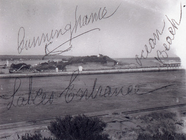 Lakes Entrance Historical Society
Photograph - New Works, 1920c
Black and white photograph showing entrance view from western pier towards eastern pier and works buildings, includes flagstaff rocket shed, township in distance, tramline along western pier in foreground, at Lakes Entrance, Victoria.Cunninghame Ocean Beachwaterways, piers, historic buildings -
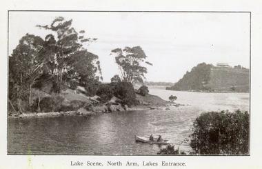 Lakes Entrance Historical Society
Photograph - North Arm, 1920c
Copy same view but titled 'North Arm - Lakes Entrance' 11.5 x 18Black and white photograph of the North Arm. It shows the calm waters of the arm which twist and turn between high scrub covered banks. Distant view of township, two people in small boat in foreground. Lakes Entrance VictoriaLakes Scene North Arm Lakes Entrancevegetation, topography, waterways -
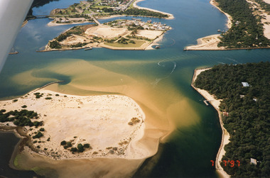 Lakes Entrance Historical Society
Photograph - Lakes Entrance, 1997
Date made 7 July 1997Colour photograph being an aerial view of entrance at Lakes Entrance, showing the sand hummocks, the sand bar offshore a fishing boat entering the channel through the bar which appears to be recently dredged township of Lakes Entrance Victoria waterways, islands, boats and boating -
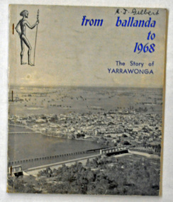 Orbost & District Historical Society
book, Yarrawonga Chronicle, From Ballanda to 1968; the story of Yarrawonga, October 1968
This book was published as part of the "Back to Yarrawonga" celebrations in October 1968 and the centenary of the First Survey of the Township of Yarrawonga.This is a useful reference tool on the history of Yarrawonga.A 90 pp paper back book titled, "From Ballanda to 1968; The Story of Yarrawonga". On the front cover on a glossy grey background is a photograph of Yarrawonga. The title is in blue print.yarrawonga-history