Showing 174634 items
matching barkly-street
-
 Port Fairy Historical Society Museum and Archives
Photograph
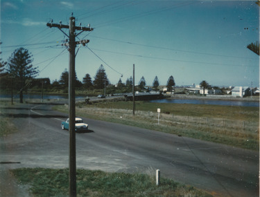
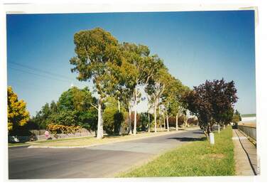
Moyne river bridge photograph taken in 1956 showing Blakes caravan park in backgroundColoured landscape of the Moyne River bridge taken from the balcony of the house (Riverside) on the corner of Regent Street and Gipps street From Tom Bartlett's Gipps Street looking East over bridge 1956bridge, moyne river, traffic, gipps street -
 Melbourne Legacy
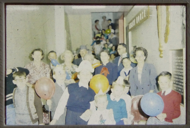
Slide, Legacy House in Market Street, 1950s
Two slide images of the staircase in the old Legacy House in Market Street, probably from the 1950s. It shows children and people gathered together, some are holding balloons and some have party hats on. Legacy rented the Market St premises for many years. It was part of the Western Market complex that was demolished and redeveloped in the early 1960s. Legacy held meetings, activities and the girls classes on the second floor of the building, accessed by this staircase, but it was barely fit for purpose. In the 1940s a generous donation by an anonymous donor meant Legacy could purchase a building at 342 Swanston St, but due to several factors were never able to inhabit it. Finally it was sold in 1954 and Junior Legacy Melbourne purchased 289-299 Swanston Street Melbourne (previously called Red Cross House) in 1956 from the Commonwealth Government.A record of the Market Street building that Legacy occupied for many years until 1956-7.Colour slide x 2 of the staircase at Legacy House in Market Street.properties, market st -
 Eltham District Historical Society Inc
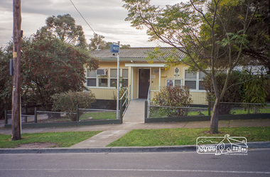
Photograph, Margaret Ball, Police Station, Pryor Street, Eltham, June 1999, 1999
In 1959 the Victoria Police purchased this house in Pryor Street to be refurbished as the Eltham Police Station. In 1961 the Police moved out of 728 Main Road and into the Pryor Street building following required modifications to bring it in line with the standards used for Police Stations throughout the State.The Margaret Ball (Pre 1960s Houses) Collection was a personal project initiated to mark the year 2000 and arose as a result of the disappearance of many pre-1960s parts of Eltham due to development. Approximately 200 pre-1960s style houses that were left in Eltham between Main Road and east to Bible Street, between Cecil Street to the north and south to Dalton Street were photographed in late 1999. Not all of the houses could be photographed; some because the garden or trees blocked the view of the house, others because of rubbish or cars were in the way, some because people were working on the house or in the gardens at the time.Roll of 35mm colour negative film, 10 stripsFuji 200eltham, houses, streets, margaret ball (pre 1960s houses) collection, pryor street, police station -
 Tatura Irrigation & Wartime Camps Museum
Photograph, Shire Office and Library, Casey Street, Tatura
Shows picture of the former Shire office and Library in Casey Street, Tatura. Colour photograph showing former Shire Office and Library in Casey Street, Tatura. Photograph stuck onto piece of white cardboard. shire office tatura, tatura library, casey street tatura -
 Tatura Irrigation & Wartime Camps Museum
Photograph, Casey Street Tatura
Shows picture of the view looking west along Casey Street, Tatura. Colour photograph showing view looking west along Casey Street, Tatura. Photograph stuck onto piece of white cardboard. tatura victoria, casey street tatura -
 Tatura Irrigation & Wartime Camps Museum
Photograph, Mechanics Institute and Victory Hall Hogan Street Tatura
Shows picture of Mechanics Institute and Victory Hall, Hogan Street, Tatura. Colour photograph showing Mechanics Institute and Victory Hall in Hogan Street, Tatura. Photograph stuck onto piece of white cardboard. hogan street tatura, mechanics institute tatura, victory hall tatura -
 Tatura Irrigation & Wartime Camps Museum
Photograph, Clock Tower intersection, Hogan Street, Tatura
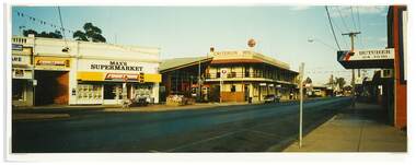
Shows picture of businesses at the Clock Tower intersection, Hogan Street, Tatura. Looking east along Hogan Street.Colour photograph showing businesses at the intersection just up from where the Clock Tower is located in Hogan Street, Tatura. Photograph stuck onto piece of white cardboard. hogan street tatura, criterion hotel tatura, max's supermarket tatura, tatura handyman's hardware, tatura post office, tatura butcher -
 Wodonga & District Historical Society Inc
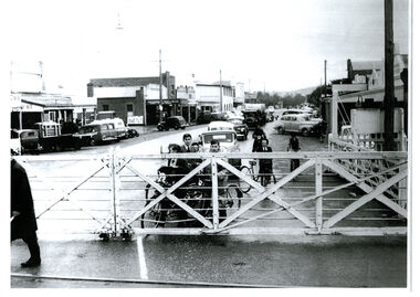
Photograph - High Street, Wodonga Level Crossing, 1954
This image is representative of many photographs illustrating the level crossing in the centre of Wodonga. Since its opening in 1873 the railway line had crossed High Street, originally called Sydney Road. It bisected the city with level crossing gates frequently stopping the flow of traffic and pedestrians as trains passed through. Signal Box B stood on the eastern side of the High Street level crossing and a big wheel closed and opened the gates. On 17th September, 1961, it was replaced by boom gates and flashing lights. The railway crossing was removed from High Street as part of the Wodonga Rail Bypass project. This involved a 5.5 kilometres bypass, the elimination of 11 level crossings and the relocation of the Wodonga station. It was moved from its original central location to a position on a new line on the northern edge of the town. The old station closed on 8 November 2008 and the new station opened on 25 June 2011.This image has local and statewide significance as it captures the former crossing in a major railway system. The railways played a critical role in opening up Victoria and connecting Australia for trade, business, social communication and transport.A black and white photo of the railway level crossing in High Street, Wodonga with gates closed. The Melbourne to Sydney railway line went through the centre of Wodonga and trains frequently held up internal vehicular and pedestrian traffic in the main street. railways wodonga, wodonga railway relocation, high st wodonga rail crossing -
 Surrey Hills Historical Society Collection
Photograph, Group of children playing in the backyard, 11 York Street, Mont Albert
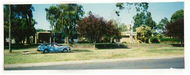
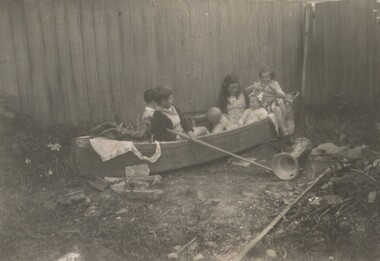
The photo probably includes Barbara, Ken and Laurie Young, the children of Ernest Lance (Lance) Young and his wife Beryl Mair who married in 1939 and came to 11 York Street during the WW2 years. The donor does not recognise all of the children. Linda Lawrence is the tallest girl; her brother Ken is largely obscured. Laurie is the youngest girl with the pigtails. Her sister Barbara is at the back. The Lawrence family lived next door at 15 York Street (there was no 13 York Street). A black & white photo of 3 girls and 2 boys in imaginative play in a canoe positioned against a timber paling fence.On rear: Photographer's processing stamp "4938"laurie young, ken young, children, barbara young, york street, back yards, mont albert -
 Federation University Historical Collection
Document, Graeme Tyrrell, Overview for the Development of Gardens Lydiard Street Campus, 1988, 01/12/1988
The report was prepared by Graeme Tyrrell, headgroundsman/Gardener at the Ballarat School of Mines (SMB) for Bob Feary, Manager of Facilities at SMB. The report was designed to present a broad cover of current plans for specific sites at the Lydiard Street campus.Seven page report on the development of the Ballarat School of Mines Gardens, including the Motor Mechanics Portable, Hickman Street (now demolished); Recreation Building (now demolished), E.P.U.Y Building, Hickman Street, vacant block behind creche (now site of UBTec building); Creche, Grant Street (now demolished); Former Courthouse building, Grant Street terrace, Brick Court yard, conifer beds lining Lydiard Street, Herb Garden above M.B. John Building, Terrraced area above Ballarat School of Mines Botanical Garden (referred to as Von Mueller garden). The report includes a campus plan. The report is copied onto white paper and is stapled at the top left corner. ballarat school of mines botanical gardens, ballarat school of mines, bob feary, graeme tyrrell, gardens, ballarat school of mines campus, smb campus -
 Stawell Historical Society Inc
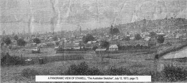
Drawing, Town & Big Hill from King Street area -- Sketch
Town & Big Hill from King Street areaBlack and White sketch drawn from King Street area St Patrick's church just right of centre. Poppet heads on skyline. A Panoramic View of Stawellstawell -
 Eltham District Historical Society Inc
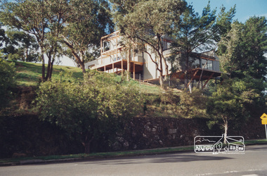
Photograph, Kinloch Gardens, 93 Arthur Street, Eltham, 1998c
New home on the Kinloch Estate as seen from Arthur Street, ElthamDigital file only; created from scan undertaken by EDHSarthur street, eltham, houses, jelbart property, kinloch gardens -
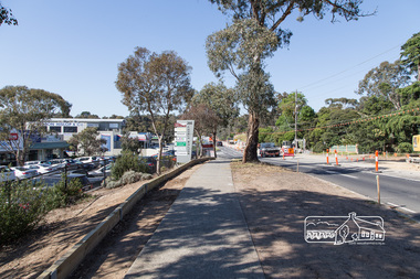
 Eltham District Historical Society Inc
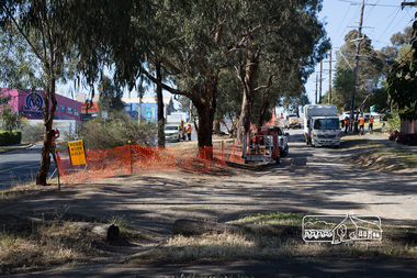
Photograph, Peter Pidgeon, Bolton Street upgrade, Eltham, 13 November, 2017, 13/11/2017
North bound lane closure, near Bridge Street, McDonalds on left. Born Digitalbolton street, bolton street upgrade, eltham, streets, mcdonalds restaurant -
 Eltham District Historical Society Inc
Photograph, Peter Pidgeon, Bolton Street upgrade, Eltham, 13 November, 2017, 13/11/2017
North bound lane closure, near Bridge Street, McDonalds on left. Born Digitalbolton street, bolton street upgrade, eltham, streets, mcdonalds restaurant -
 Eltham District Historical Society Inc
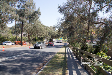
Photograph, Peter Pidgeon, Bolton Street upgrade, Eltham, 13 November, 2017, 13/11/2017
North bound lane closure, near Bridge Street, McDonalds on left. Born Digitalbolton street, bolton street upgrade, eltham, streets, middy's -
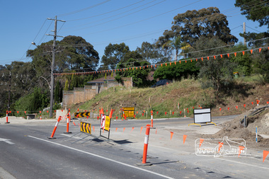
 Eltham District Historical Society Inc
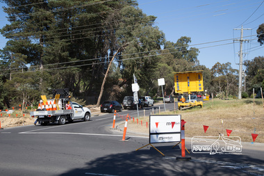
Photograph, Peter Pidgeon, Intersection with Grand Boulevard, Bolton Street upgrade, Eltham, 13 November, 2017, 13/11/2017
North bound lane closure, near Bridge Street, McDonalds on left. Born Digitalbolton street, bolton street upgrade, eltham, streets, grand boulevard -
 Eltham District Historical Society Inc
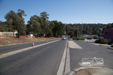
Photograph, Peter Pidgeon, Bolton Street upgrade, Eltham, 13 November, 2017, 13/11/2017
North bound lane closure, near Bridge Street, McDonalds on left. Born Digitalbolton street, bolton street upgrade, eltham, streets, eltham ridge, shops -
 Eltham District Historical Society Inc
Photograph, Peter Pidgeon, Intersection with Pedersen Way, Bolton Street upgrade, Eltham, 13 November, 2017, 13/11/2017
North bound lane closure, near Bridge Street, McDonalds on left. Born Digitalbolton street, bolton street upgrade, eltham, streets, pedersen way -
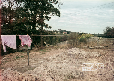 Eltham District Historical Society Inc
Photograph, Russell Yeoman, 66 Susan Street, Eltham, c.1965, 1965c
Looking southeast from backyard, Bridge Street visible under washing.Digital file only; created from original colour positive slide transparencyeltham, streets, susan street, eltham skate park, alistair knox park, bridge street, russell yeoman collection -
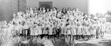 Surrey Hills Historical Society Collection
Photograph, Benson Street Methodist Church Sunday School, 1950s
Primary classes of the Benson Street Methodist Church Sunday School, 1950sA black and white photograph of a large group of small children and ladies standing outside a building.benson street uniting church, churches, benson street, surrey hills, clothing and dress, 1950-1959, sunday school -
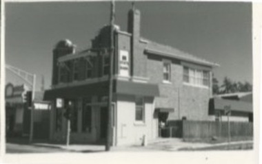 Kilmore Historical Society
Photograph, 27 Sydney Street
14cm x 9cm black and white photograph of the building at 27 Sydney Street. The occupants of the building at the time of the photograph was the State Bank. Double story building with a semi-rendered facade and a medium toned brick building, with a wooden fence on the side. There is a side access ramp, and an analog clock on the front of the building.Written on the building: 27 Syd SSB IIIbank, state bank, banks and banking -
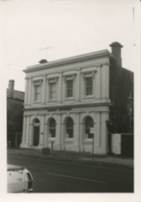 Kilmore Historical Society
Photograph, 39 Sydney Street, 1980's?
Was the building which housed the Old Colonial Bank of Australasia Ltd.9cm x 12.5cm black and white photograph of the building at 39 Sydney Street. The double story building has an ornate light-coloured facade, which darker brickwork on the sides. Arched windows on the ground floor and rectangle window with trim on the top floor. Signage on the building states "Dornal Antiques".storefronts, retail store, antique dealers, antiques -
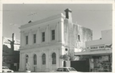 Kilmore Historical Society
Photograph, 39 Sydney Street, 1980's?
Was the building of the Old Colonial Bank of Australasia Ltd. At the time of the photograph operating as a doctors office.14cm x 9cm black and white photograph building at 39 Sydney Street. The double story building has an ornate light-coloured facade, which darker rendering on the sides. Arched windows on the ground floor and rectangle window with trim on the top floor. The newsagency neighbouring the property can be seen.Written on the back: 39 Sydney Coll Bank 115store front, shop front, antiques, antiques dealer -
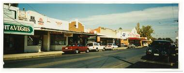 Tatura Irrigation & Wartime Camps Museum
Photograph, Hogan Street, Tatura
Shows picture of a few of the businesses in Hogan Streets, Tatura. Fresh Fruit and Vegies, Newsagents, real estate, Kings Family Tuckerbag.Colour photograph showing a few of the businesses in Hogan Streets, Tatura. Photograph stuck onto piece of white cardboard. hogan street tatura, tatura businesses, tatura newsagency, kings family tuckerbag -
Hume City Civic Collection
Book - Street Directory, Gregory"s Melbourne Street Directory
This 1972 Gregory's Melbourne Street Directory published by Gregory's Guides & Maps Pty Ltd was used by the donor, her husband and family.A black leather removable cover with gold embossed vintage car on the front enclosing a Gregory's Melbourne Street Directory.Gold embossed vintage car on front cover.joan houston, maps, street directory, roads, suburbs -
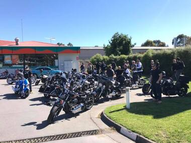 Greensborough Historical Society
Photograph - Digital Image, Marilyn Smith, Were Street Christmas celebrations 2018. Motor bikes, 2018_12
The 2018 Christmas celebration in Were Street Montmorency included this group of motor cyclists.Digital copy of colour photograph.were street montmorency, were street montmorency christmas 2018 -
Ballarat Heritage Services
Photograph - Black and White, Davies the Baker, Eureka Street, Ballarat
The site of Davies the Baker became a playground west of the Eureka Street Primary School.A wide panoramic photograph showing numerous Davies Bread Bakery trukjs and drivers, and two members of the Davies family. They are standing together and are Frederick Tablot Davies, Mr Davies Senior, and Foreman Hector Godfrey's Smith.davies bakery, eureka street, frederick davies, hector godfrey smith -
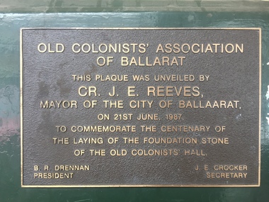 Old Colonists' Association of Ballarat Inc.
Photograph - Photograph - Colour, Centenial Plaque on the outside of the Old Colonists' Hall, Lydiard Street North, Ballarat, 21/06/1987
Plaque commemoting the centenary of the Old COlonists' Hall in Lyduard Street North, Ballarat,Old Colonists' Association of Ballarat This plaque was unveiled by Cr. J.E. Reeves, Mayor of the City of Ballaarat, on 21st June, 1987, to comemorate the centenary of the laying of the foundation stone of the Old Colonists' Hall B.R. Drennan J.E. Crocker President Secretaryold colonists' hall, j.e. reeves, b.r. drennan, j.e. crocker, centenary -
 Surrey Hills Historical Society Collection
Photograph, 3 Beatty Street, Mont Albert
Original address was No. 1 Victoria Street; became 3 Beatty Street in 1969. Occupants: 1891-1905 Leopold Augustus Carter, Collins Street dentist (see Alan Holt cards for details of tenants); son of Ernest Carter, dentist, of 'Shrublands' in Balwyn Road, Canterbury. 1905-1909 James Johnston Hemphill, Esquire 1909-1919 G. E. Jeans, Gentleman 1919-1920 Colin Friend, medical practitioner 1920-1964 Augustin Lodewyckx 1964-1967 Mina Lodewyckx 1967- Lodewyckx family A black and white photo of a house surrounded by trees, possibly fruit trees.beatty street, mont albert, victoria street, leopold augustus carter, james johnston hemphill, augustin lodewyckx, mina lodewyckx, lodewyckx family