Showing 954 items
matching bluestone%20buildings
-
 Eltham District Historical Society Inc
Film - Video (VHS), Jenni Mitchell, Demolition of the Shire of Eltham Offices, 1996
Poor video quality (noise and interference), incomplete and unedited raw footage. A video documenting the demolition of the Shire of Eltham offices at 895 Main Road Eltham under the direction of the Commissioners appointed for the new Shire of Nillumbik and some of the communities activities surrounding the event. The building was demolished exactly 25 years after the southern wing housing Engineering and Planning on the upper level and the Eltham Library on the ground level was opened in celebration of the Shire of Eltham's centenary. Video has lots of distortion and noise, and sections of clips dubbed over. Immediate initial footage of Jenni Mitchell talking about asbestos claims in the Shire Offices (Sigmund Jorgensen standing behind her) advising Council did a review of the building several years previously and had been cleared of health problems. Cuts to group of people standing outside front door of offices but possibly voice dub over not related ? Then the date 27 Jul 1996 on a scene flashes on screen immediately followed by an edited clip intro of title and credits with classical music track. It then opens with Jenni Mitchell driving to the Shire Offices on Saturday 27 July 1996 at 11.00am. Footage of Main Road past Pitt Street, Alistair Knox Park then entering Shire Office driveway which is fenced off and contractor signs hanging up. Scenes at rear of building showing some internal demolition has commenced. View of the Administration wing. More clips of road driving, Alistair Knox Park, Eltham Library and visitor car park for Shire Offices. Cuts to a group of people standing in access to visitor carpark with new Eltham Library in background, one being immediate former Shire of Eltham President, John Graves. Scenes of people looking through chain link fence and security guard checking front door. John Graves being filmed that someone informed him the Shire was offering the building to the Community Health Centre for $2.3 million and that if they had been offered a price of $1.1 for what it apparently was sold for they would have snapped it up. View of truck loaded with brick rubble literally struggling to ascend the hill of Library Place to exit into Main Road. Cuts to a scene looking at Eltham War memorial Hall through the Memorial Gate, then the Shillinglaw trees and large banner sign ‘Delta Demolitions’ hanging on office façade. Views of front door, old library and bluestone wall. Scene (31 Jul 1996) filmed at night of several white crosses with “RIP Community” and “RIP Democracy”. Scene (1 August 1996) again driving along Main Road towards the Shire Offices then scenes of the offices showing substantially more demolition to exterior, groups of people standing on footpath outside watching, Delta heavy demolition machines, woman holding sign “Democracy where have you gone …”, the odd person in full protection gear and breathing apparatus hand carrying materials out to place on rubbish pile in front of people standing on footpath watching (with no protection) and then stamping on it to break it creating dust, security person in hard hat (no other protection) wandering around, many groups standing around watching, news film crew, person standing on roadside edge holding signs facing traffic stating “Pirate Planning” and “ Grant us your ears” also sign on back of parked car “Elthams High Jacks”, another sign “Community Democracy”, views of crosses in Main Road median strip “RIP Community”, groups of people on footpaths and reporters conducting interviews, footage of unknown person standing with Jenni Mitchell and Sigmund Jorgensen advising people have the right to protest, Jenni Mitchell urging people to ask questions of local MP and Council and Sigmund Jorgensen referring to the three historic Shillinglaw trees with demolition machinery operating in background, Jenni Mitchell and others installing more crosses in median strip; demolition machines operating inside and outside the building, more views of onlookers including Sigmund Jorgensen then Police approaching on footpath, workers and machinery continuing to operate, views of the old library being demolished, the former Community Services department, security personnel. Scene (2 August 1996) more heavy demolition machinery in operation smashing building up, people standing around southern wing watching, view overlooking Eltham Library of train pulling in to Eltham station. Scene (7 August 1996) more heavy demolition and people wandering around with only hard hat protection, no dust protection, comments from one operator dumping a bin of material stating “wait till there’s a Hungry Jack’s here, you’ll be laughing, fuel, videos, hamburgers. You’ll be up with the rest of the world soon, you’ll have electricity and everything here, ha ha ha ha”, more heavy machinery demolition and breaking up of materials, view of Hitachi train going by and Administration wing, view inside the front door opening of the staircase leading to upper level, person walking around operating heavy machinery with a hose spraying rubble (no protective gear other than hard hat interspersed with edit cuts of meeting of Commissioners and independent observers on panel as well as members of the community in public gallery. Nillumbik Shire CEO Barry Rochford addressing the meeting., Chief Commissioner Don Cordell directly addressing Jenni Mitchell with respect to permission to take photographs, Barry Rochford continues to address the question asked of Council about the valuation of the former Shire of Eltham Office building/site, public gallery calling out asking why was building demolished, what was the urgency. Scene (14 August 1996) views of southern wing, previous single demolition operator again mocking people filming, operators working in and around building, Shillinglaw trees and largely demolished front, heavy demolition equipment at work, piles of building rubble, hose spraying water over rubble, large trucks arriving for rubble removal and loading of truck. Scene (21 August) more of the same, building virtually down, Shillinglaw trees standing tall and alone, water spraying on rubble and wattle in bloom. Cuts to Council meeting with public onlookers. Barry Rochford walks out, Wayne Phillips addresses meeting explaining one or two people shouting, members of the community challenging Council (Commissioners) about why due process appear to have been subverted. Former Shire President Robert Marshall in public audience, cuts back to Shire office carpark entrance site and sign hung on fence in front of library “Think Again!” and people standing around observing awaiting a protest demonstration erecting a large sign on stilts stating “Shell No!”, people singing a revised version of God Save the Queen (God Save Us All), Sigmund Jorgensen in attendance, Jenni Mitchell, Sigmund Jorgenson and others address the protest crowd, followed by people mingling, music being played then people standing around the cleared site circumference all with arms linked (video very broken up with noise) then chants “Save the Gateway” and “No Shell for Eltham” and more music and singing “Put up a parking lot”. The crowd then proceeds to walk along the footpath of Main Road. Scene (15 Sep 1996) meeting at Montsalvat in Great Hall addressed by Sigmund Jorgensen discussing a recently published list of the Commissioner’s to senior Council Officers of banned Nillumbik people, others encouraging people to view proposed plans for the site and lodge objections. Specific issues regarding asbestos claims are also addressed. Harry Gilham addresses the meeting on the subject of the Eltham War Memorial and Memorial Gardens and how Council believe a roundabout in the vicinity is of greater importance. Views of various artworks on display (for auction) and music performance in the Barn Gallery. Meeting addressed by Sigmund Jorgensen discussing an appeal against Council granting a permit to Dallas Howgate to develop the site and that the Minister has called the matter in to be decided by the governing council. This is followed by an auction of paintings.VHS Video cassette (poor quality) Converted to MP4 file format 45:01, 535MBvideo recording, 895 main road, alistair knox park, artworks, auction, barn gallery, barry rochford, community health centre, dallas howgate, delta demolitions, demolition, don cordell, eltham, eltham library, eltham shire office, eltham war memorial, eltham war memorial gate, eltham war memorial hall, great hall, harry gilham, jenni mitchell, john graves, library place, main road, memorial gardens, mervyn hannan, montsalvat, pitt street, protest, robert marshall, roundabout, shell oil, shillinglaw trees, sigmund jorgensen, sign, wayne phillips -
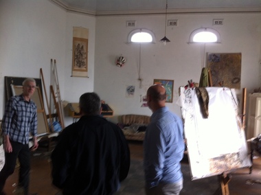 Freemasons Victoria - Gordon Lodge, 99
Original Gordon Lodge lodge-room 1886
A picture of the original Gordon Lodge lodge-room of 1886 - room currently in use by the Lodge's artist-in-residence. Below is a newspaper article from the North Melbourne Advertiser (Vic: 1873 - 1894) for Friday 22 April 1887 that describes the architecture of the building at the time of its completion. From some of the details included in the article it is obvious that the journalist who wrote the article was a Freemason. THE MASONIC HALL ASCOT VALE North Melbourne Advertiser (Vic. : 1873 - 1894) Friday 22 April 1887 THE MASONIC HALL ASCOT VALE The now Masonic Hall, Ascot Vale, the foundation stone of which was laid by the Worshipful Master of the Gordon Lodge (Bro, W. F. Lamonby) in October last has just been completed, and will be formally opened: with grand Masonic ball on the 13th prox. The hall stands on a fine block of land having a frontage of 50ft to the Maribyrnong road by a depth of 130 ft., and is built of brick and cement on a most substantial foundation of bluestone. The Tuscan style of architecture has been adopted with the most successful result, and the front design which is especially handsome, includes four massive pilasters with frieze architrave and enriched cornice, forming the entablature of the order,- and giving a most imposing appearance. The front door, over which are the masonic emblems, is seven feet wide, and two escape doors made to open outwards in compliance with the Central Board of Health regulations are also provided, in case of emergency. In the vestibule is a very fine elliptic arch with keystone enriched with fruit, and the whole floor, 9ft. 6in. wide, is laid with Cawkwell's encaustic tyles. On the right, of tile vestibule is a commodious committee room 22ft. by 12ft 6in with side entrance for members, so that in case the main hall is engaged no inconvenience need be caused. On the left is the Secretary's room, and off this again is a staircase cellar. The vestibule is well lighted with two exceedingly pretty chandeliers, which have a very pleasing effect and give it a nice bright appearance ascending a handsome staircase leading from the vestibule the upper storey is reached, and here everything is splendidly arranged, especially 'the Lodge Room, which is a model of neatness and of comfort. The dimensions are 28ft. x 22ft 6in. with an elevation of 17ft. 6in. to the beautiful cove ceiling, which is quite a work of art. At the east end of the room on a raised dais is the master's chair with the masonic emblems, and neat forms of polished kauri are placed at the sides for members, about 150 of whom can be accommodated. The lighting and ventilation have both been well attended to and all is very complete. The main hall is 75ft. by 35 ft. with a stage 15ft. deep, leaving the auditorium 60ft. x 35ft. with a seating capacity about 600. Round the walls up to 6ft 6in. is a handsome dado in Portland cement and above it are panelled Tuscan pilasters to the entablature, architrave enriched frieze and medallion cornice forming the main cornice to the hall. Immediately inside the cornice is a sunken panel all-round the ceiling relieved with ornamental outlet ventilators. There are twelve large windows, six on each aide, and the sashes, skirting boards, and doors throughout the building are beautifully painted in imitation of grained cedar. Two enormous gas reflectors, each for 50 lights are suspended from the ceiling and besides these, four elegant hanging chandeliers for lighting up the proscenium, and back of the stage, under which is a storeroom for seats, &c, when the hall is required for a ball. The floor is made of kauri, secretly nailed, and is beautifully finished off. At the back of the stage are two lavatories and ladies and gentlemen's dressing rooms, between which are a connecting passage for a call boy. Outside is a capital asphalted yard, and the other usual conveniences on an improved plan. There is a right-of-way asphalted on each side of the building, and a large lamp is to be placed opposite the main entrance to light up the front. Everything that forethought and ability could suggest to make the hall comfortable and popular has been done, and it now only remains for the public to avail themselves of the advantages offered them by the enterprising Company. The cost of the building and furniture, including a magnificent piano, was £2,500, and the land £300. Mr J. C. M. Cowan, of Ascot Vale, is the architect, and Messrs Parker and Pater, of South Melbourne, the contractors. The plastering was done by Mr I Nicholas, of Murray Street, Moonee Ponds, who is also entitled to great praise for his splendid workmanship. Mr Cowan has been most assiduous and particular in seeing that his instructions were carried out to his satisfaction, and the result must be exceedingly gratifying to him and to the directors. The Masonic hall is only one of the many buildings erected by Mr Cowan in this district, among the others being the well known residences of Meessrs. J. Levy, Mooneo Street; W. Murphy, Eglington street; G. Groube, Maribyrnong street; C. A. Arvier, Moonee Ponds ; and F. Paul, Mount Alexander road. It may also be mentioned that Mr Cowan generously presented the plans for the now local fire brigade tower which is acknowledged to be one of the strongest and most graceful around Melbourne, The new Masonic Hall does infinite credit to the borough, and in accommodation, design, and comfort it is not surpassed by any similar building of the kind outside the city. -
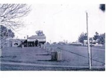
 Eltham District Historical Society Inc
Photograph, Tess Justine (Nillumbik Shire Council), Murray's Bridge over the Diamond Creek, Eltham North, 19 Feb 2022
Murray's Bridge over the Diamond Creek on the Diamond Creek Trail just prior to demolition and replacement with a new steel bridge. Heritage advice obtained by Nillumbik Shire Council, following a suggestion by the Eltham District Historical Society (EDHS), is that the original bridge appears to have been a simplified version of the Country Roads Board’s (CRB) standard timber bridge design of the early-to-mid 1920s. In c1990 Murray’s bridge was renovated with three recycled steel girders as part of a bike/pedestrian path in the reserve. During these alterations many parts of the bridge were removed, and some were replaced. Heritage advice indicates the condition of Murray’s bridge is poor. The remaining original parts are all in poor condition, with severe weathering, splitting and rot, especially to the stringers retained on the bridge. Heritage advice is that Murray’s Bridge does not have sufficient significance in the cultural history of the Nillumbik area to warrant inclusion in the Nillumbik Shire Heritage Overlay and also does not have sufficient significance as a rare survivor to warrant inclusion in the Nillumbik Shire Heritage Overlay. There are no indications in the historical record that this site was individually important to the cultural history of this area. EDHS is comfortable with the heritage advice provided to Council and has worked closely on this project with Council. EDHS has suggested some of the removed timbers be used in the vicinity of the bridge for landscaping and possibly seating, so as to retain these remnants close to the site of the original bridge, which is the last old timber bridge along the lower reaches of the Diamond Creek. Mary (Sweeney) Murray and John Wright Murray selected 80 acres, Lot C Section 16 and Lot 5 Section 17 Parish of Nillumbik, under an occupation license in 1866. John died in 1867 and freehold was granted to his son John in 1873. The farm was known as ‘Laurel Hill’. John Junior was an Eltham Shire councillor and sometime president from 1887 up until 1897. He added Lot A Section 16 to the farm in ca1888. John and his younger brother James arranged to rent/purchase Lot B Section 17, across Diamond Creek to the west, in ca1900. It appears that John and James farmed separately for a few years, with a new homestead built for James ad family on the high point of Lot B Section 17 in ca1910. John sold off Lot 5 Section 17 in 1912. When John died in 1912 James took over the land on both sides of the Diamond Creek. The old homestead on the west side of the Creek disappeared. A farm bridge over Diamond Creek from this period may have been located close to the northern boundary of the farm. John Langlands, owner of the farm known as ‘Ihurst’ on the west side of Diamond Creek to the south of the Murray’s land, died in 1907. In 1909 his land was then subdivided into 100 lots to become the ‘Glen Park Estate’. Other similar subdivisions of nineteenth century farms around Eltham in this period included the ‘Franktonia (or Beard’s) Estate’ to the northeast and ‘Bonsack’s Estate’ between Eltham and Greensborough. Soon after the opening of the railway extension line from Eltham to Hurstbridge in 1912, Glen Park and nearby residents including James Murray agitated for a railway station or siding to be located half-way between Eltham and Hurstbridge, so that the Glen Park residents who used the railway daily did not have to walk into the Eltham or Hurstbridge stations. Some believed Coleman’s Corner (opposite Edendale Farm) was an appropriate spot for the platform. James Murray was among those who thought the railway should be located on his land, closer to half-way between Eltham and Hurstbridge stations. The Railways Commissioners warned that the locals would have to fund these works themselves. The Glen Park Estate residents initially had difficulty accessing Eltham by road, with only an old low-level bridge over Diamond Creek at the south end of their estate. A new timber trestle bridge across the creek, now on Wattletree Road, was opened in 1915. Road access to the north was gained in 1927 when the new Murray’s Road, which crossed the Murray’s land, was built. Residents continued to agitate for a Glen Park station. By 1926 the Railways Commissioners’ preferred site was on the Murray’s land. They arranged an estimate of cost of a full-length platform. The estimate was too much for the locals, who in 1928 argued unsuccessfully for a shorter and hence cheaper platform. By 1929 Murray had agreed to donate the land, but the locals would still have to fund the works. Murray decided, unilaterally it would appear, to commence work on a timber trestle road bridge over Diamond Creek to link the new Murray Road to the proposed station. Late in 1929 he stopped work on the bridge, for reasons unknown, but started work again and completed the bridge in 1931. There is no further newspaper evidence of the campaign for the Glen Park station until 1939, when Murray and another local, Mr Maxwell, met the Railways Commissioner. The Glen Park locale now included 45 homes on the west side of the creek and 20 on the Eltham side. Most of the residents used the train every day. The Commissioner remained adamant that only a full-length platform could be built for safety reasons. It appears the campaign dissolved at this point. The increasing move to cars may have had an impact. There is no evidence of Murray’s bridge ever being connected to Murray’s Road, or of it having wide use for any purpose by locals. James Murray died in 1947 and the farm was taken over by his son James (Jim). Jim started to sell off parts of the farm in the 1980s, retaining a few acres around the ca1910 homestead and building a new house there. Recreation reserves were established along the creek. In ca1990 Murray’s bridge was renovated with steel girders as part of a bike/pedestrian path in the reserve. The old farmhouse was demolished in ca2014. * * * A theory posted on local community Facebook groups was that the bridge was built in the 1860s and was built to be more robust than was necessary for the movement of cows from one side of the creek to the other. It was suggested the robustness was necessary to support the weight of gold ore being transferred from a mine on Murray’s land to a railway siding near Murrays Bridge (presumably for transfer and processing at Diamond Creek). Perhaps this may have been one of the motivators for Murray, who really knows? Knowing when mining operations ceased on his land and how that fits the overall timeline would be useful but at the time the bridge was built, local gold production was minimal at best. The known facts are: • The railway line came to Eltham in 1902. • The extension of the railway from Eltham to Hurstbridge was constructed in 1912 so no railway line even existed through Murray's property until 1912 and the Victorian Railways maps at the time show no such siding on Murray’s property. • In 1923 a new company was formed in anticipation of the old Diamond Creek Gold Mine being re-opened. The mine had been previously closed and flooded. It was noted in the press at the time that the mine was within a mile of the railway. Nothing really came of this. • Construction of Murrays Bridge was commenced by James Murray in early 1929 in anticipation of a proposed flag station being nominated on his land, but work ceased shortly afterwards. The proposed flag station was commonly referred to as Glen Park as the residents of the Glen Park Estate wanted Option 1, located near them with the platform adjacent to Colemans corner. This was probably never going to fly as it was virtually in eyesight of Eltham station. Allandale Road was the third option, but the Commissioners' preferred option was No. 2 - on Murray's property. • The Railway Commissioners were not going to finance any such station and the works had to be funded by private landowners and residents, hence Murray investing in this himself. • Murray recommenced work two years later and finished his bridge in 1931 but unfortunately for him, the proposed flag station never eventuated. The bluestone siding you reference may well have been built by Murray as part of the proposed station platform. • Up until then, apart from the Main Road bridge, which was washed away in 1924, virtually all local crossings over the Diamond Creek were low lying bridges – Kaylocks Bridge at Brougham Street, Diamond Street bridge, Glen Park Road bridge. It is expected that Murray also had a low-lying bridge to connect his land either side of the creek. These were all washed away or severely damaged multiple times in the 1920s. Lessons were learnt, and Murrays Bridge appears to have been built in accordance with Country Road Board standards of the time. Flood damage was ongoing, and even more recently constructed raised bridges kept getting washed away, e.g., the new Wattle Tree Road bridge in 1958 just months after completion. Murray’s bridge was reinforced with steel some 30 years ago presumably to provide additional floodwater resistance, given the history of bridges disappearing in floodwaters. • In March 1932 it was reported in the Advertiser that there were still some prospectors operating around Eltham North who apart from further scarring the face of the earth over the previous two years had gained significant experience but little gold - hardly a driving factor for constructing a dedicated railway siding and bridge to transfer gold ore. It is far more probable that James Murray was hoping to have the railway station located on his property and invested his money by building the bridge to lead to it as well as a station platform. Had the station eventuated, it may well have driven up the value of his land for subdivision and new housing estates like the Glen Park Estate. That did not eventuate. Whilst the bridge was indeed old (90 years), the core structure being completed in 1931, it had been modified substantially from original and hence had no significant historic value – i.e., it was not a representative example of its type, construction, and age. Given that the bridge was not worthy of saving, the Eltham District Historical Society with Council’s support, and the Eltham Woodworkers group endeavoured to see what suitable sized timbers were salvageable to fabricate a commemorative seat. Unfortunately, the experts at the Woodworkers group were unable to salvage any suitable length/width timbers to fabricate the seat due to the presence of rot. Last remaining wooden trestle bridge on the Diamond Creek Trail just prior to demolition and replacementBorn digital image (27)diamond creek (creek), diamond creek trail, murrays bridge, ‘laurel hill’, john wright murray, mary (sweeney) murra, john murray jnr, james murray, john langlands, ‘ihurst’, ‘glen park estate’, beard's estate, franktonia, bonsack's estate, glen park estate, glen park railway station -
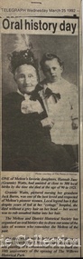 Melton City Libraries
Newspaper, Oral History Day, 1992
Mary Tolhurst M&DHS - March 29th Dunvegan Willows Park Melton 1992 Ladies Oral History Day Graham Minns President Ray Radford MC Sound recording transfer to CD 2011 by Tom Wood Edited typescript by Wendy Barrie 2013 I was born in Rockbank, and when I was five years old moved to Toolern Vale and started and finished school there. Toolern Vale only consisted of the Store, Post Office and shop, where you could buy your fodder, and pollard supplies, the Hall, the little Church and the bluestone School. The School changed shape three times from the 1800s[1869] til the time I went there. There was four generations of my family that went there and it was destroyed by fire in 1965. Marjorie nee Myers Butler. Yes, I remember along with it your lovely Ronisch piano. Mary, quite true! Marj what you say about the Ronisch piano. When I came the age to learn music my mum and dad couldn’t really afford it, but still what parents do for their children. They had Marj go along with them and pick this lovely Ronisch piano. It was known round the district. Everyone commented about the loss that lovely piano. After leaving school it was war time, 1939, then it was work, When I was 7 year old I was put out into the cow yard. In 1940 when the soldiers were going away our milk was confiscated it had to go to Bacchus Marsh. It used to go the Sunbury to be brine cooled and then go to Melbourne. Then they took it then to the Lifeguard Milk Factory at Bacchus Marsh. It had to go as condensed milk to the soldiers. This year is 50 years of the Land Army. I was an unofficial Land Army but they still kept check on me. I went onto married life and I followed the cows right through [howls of laughter] and we went on until the 1965 fire. That’s when we got out of the cows. Marjorie asks, was Granny Watts your grandmother or great grandmother? Mary: She was my great grandmother, the midwife of Melton. The 1965 fire started ¾ of a mile above our place, Frank Ryan’s sheds were burnt and his house was saved, then it wiped the School out, the Hall, the Church the Post Office and Store and little house that was Charlie Charlton’s in the early days. Mrs Wilson’s place was saved by the Fire Brigade by pulling boards off the side, and from there it went over the hill and it was stopped at the Rockbank Railway Station. If it had of got over the railway they said it would have gone into Werribee. A lot was burnt out in that strip. Mary nee Nixon Collins: 18 houses burnt that day. Audience question, did Melton get burnt that day? Ray: No. It came down through the Toolern Vale road and cut across about a mile and a half from the cross roads at Toolern Vale from north westerly to the south east and cut through over the Keilor road. Mary: It came in across the creek at Funstons in Toolern, then through Jim Minns. Dorothy was it your place then [nee Knox Beaty] to Ken Beatty’s and from there it went through to Doug McIntosh’s and to Cockbills and the wind changed and it came across to the railway line, and that is where they stopped it. [the cause of the fire was controversial, they had been burning off the night before and there was some talk of someone starting it. It was very hot and very strong wind, it was a terrible day] Ray: When the fire went through McIntosh’s they had a haystack on the north side of their house and the haystack got caught and the fire burnt a hole through the side of the house and the boys pyjamas on the bed. The house was saved. It came through like and express train roaring at you, I was at McIntosh’s when it went roaring past. You couldn’t see, dust and ash and tremendous heat. The fire started about 12 o’clock Jack [husband] said to me, fire, I said where, where? Just up the road, what have I got to do? and he went out and he had gone to the fire and left me. I tried to get the animals and I put out buckets of water, putting the buckets of water out saved my life. Chas Jones and another friend of his came in and they picked up the buckets of water, I thought I had better get out because the fire was on the haystack up the paddock and when I went to go out through the north side of the house and couldn’t get out, I’ll go through the front gate so I went around the other side of the house. I got caught there and Chassy Jones and his friend came round carrying the bucket of water and I panicked. He threw the bucket of water over me. Well that is what saved my life because I was damp, whenever we tried to leave the ball of fire came over me and over my shoulder and my hair was scorched. Chassy Jones lost his truck and Keith Watt his big truck because he had the water tank on it and they couldn’t get out of the yard. Granny Watt’s house, the first private hospital had condemned and Jack and I pulled it down and had it moved up to Toolern and had it in the yard a fortnight and it was all burnt and we didn’t get the shed we wanted. Every 13 years right up until Ash Wednesday fires, there has always been fire close at hand. The 1952 fire went down the back of the house, the 1965 fire took the house, and the house that I live in now, it is the third house that has been on that spot. When the Hunters owned it, Mrs Hunter was nearly burnt in her bed. They had a 13 roomed house. In 1924 the house burnt down, and there was another house was built there and that was the one that burnt down. Edna: So Mary built a brick veneer house. Marjorie: like the three little pigs [laughter] Collins - Mary M &DHS - March 29th 1992 Ladies oral history day at Dunvegan, Willows Park Melton. Graham Minns President Ray Radford MC Sound recording transferred to CD 2011 Edited typescript by Wendy Barrie 2013 Mary Collins nee Nixon born in Terang 1907 down in the Western District and we shifted to Melton when I was 5 and a half then I started school here in Melton, and spent all my school life at Melton State School, next to the Church of England, it’s called the Primary School now. I got my Qualifying and Merit Certificate then I left School because there wasn’t a High School. When I was 16 I got and job in the Melton Post Office and I worked there, I was the first girl in Melton to deliver the mail, and worked on the telephone and the Bank business. Mrs Ross and myself behind the counter, there were about 500 – 600 people in the Shire at that time and now when I go into the new Post Office there is 36,000 here there’s still 2 people behind the counter [laughter from the audience] and wait in a queue right out to the door. Times haven’t changed much have they! There was a manual telephone and you had to ring the handle, and there were eight subscribers when I went there and when I left there were 46 I had coaxed that number to join the telephone, even the police station didn’t have the phone on. The two Hotels and the two Chaff mills and Mr Ernie Barrie, Parkers the butcher, the Shire Office was No 8, and the Police house was next to the Courthouse on the corner. They were number 9. I can remember a lot of the numbers still. The Post Office was the Agency for the Commonwealth Bank [comment from audience member] I used to do the Bank business too, I left after four years there, mother wasn’t very well. The Inspector who used to come up to the Post Office asked me if I would take up casual Post Mistress and to go around the different districts but I refused and when Mrs Ross’s holidays were due I was the replacement. I wasn’t 21. I loved my work meeting everybody and most people had horse and jinkers and when the elderly would come in there would be Mr Tom Morrow, he only had one arm and Mrs Dunn came from Bulman’s road in their horse and jinker. They were elderly I would see them pull up out the front and quickly get their mail and run out to them because they didn’t have to get out of the jinker to tie up their horse. If someone had a baby in arms I would tear out and hold the baby while they got down. Mrs Ross was very very strict. I had to sweep the Post Office, she had a couple of mats and there would be a threepence or a sixpence under the mats show she knew whether I lifted the mat, I was whether I was honest or not. Graham: How much were your wages? I got 27/7 pence a week for a 52 hour week. I had to work every holiday except Good Friday and Christmas Day and even when it was Monday holiday I always had to go to work from 9am - !0 am, the Post Office was always open. In the winter I had to wait until twenty past six in case there were any telegrams to deliver. I delivered them on a push bike. One time Tom Barrie told me this years afterwards. I used to go home for lunch. We lived on the Keilor road and I used to ride my bike home. On the hot days the boys used to go and swim in the swimming pool down near a turn in the creek there was a hole where the boys would swim in the nude, they didn’t have any bathers and they didn’t have any watches in those days. Tom Barrie said they always used to watched for me as I was always about 3 minutes past 1, my lunch hour was from 1-2. One particular day they missed seeing me and swam on, and of course they were all late for school when they got back and were all kept in a night. I did get a fortnight holiday. I loved my work and I knew everyone in the district right from Toolern Vale to the Marsh and everybody at Melton South. Did you listen into conversations on the Switchboard? Oh no. [laughter] Melton did not have electricity then. I had to fill the lamps everyday with kerosene. The Staughton Memorial was outside the Post Office. It had four posts with the chain looped around it, and that’s where the people used to tie up their horses. Marjorie nee Myers Butler comments about sitting and swinging on the chains. Mr Fred Coburn lit the acetylene gas light in the Memorial. It was the only streetlight in Melton. There was no electricity until 1939. Ray Radford comments about another gas street light which was on the corner of Station road. [later] Mary passes around her school photos. Mary mentions the names of those who have passed away, Maisie McDonald, ,Marian Wraith, Hilda McCreey, and Valda McDonald. I have written the names on the back. Marjorie comments about Marie Jongebloed and Greta are the only two girls left out of big family of ten I think there were [hesitates] 4 or 5 girls and the rest were boys. Mary. Flora Woodley, Dorrie Flynn and Margaret McDonald are still alive. They are my age we were all born about 1907. Marjorie points out herself in a later photo [1921 and 1922 School ] Mary mentions the name Walsh and identyfies following names, the Parker boys, Ken Beaty, Malc and Linda Cameron, Maisie Mc Donald, Ted Radford, George Nixon, Norman Minns, he was later the Shire Secretary of Werribee. One of the Woodley girls. [Maisie Arthur] Marjorie: Rosie Shearwood, June Whiting Mary. Lily Mc Donald, she has passed away. Isabel Harrison nee Tinkler, she lives at Werribee, Doreen Rogers, Marjorie Walker, Jess McIntosh, Mary Gillespie. Mr Malone was the Junior teacher Mr Roe and Miss Cooke. Fred Myers, my sister [Elizabeth] and the year was 1921. Myers (Barrie) School Photo Collection. Many of the names were identified at the 1970 Centenary of Melton State School No. 430. Edna Barrie organised, compiled and typed the lists to accompany these photos for the year 1921. The 1922 photo shows the higher grades. Ladies Oral History Day event held by Melton and District Historical Society, article featured in the Telegraphlocal identities, local special interest groups -
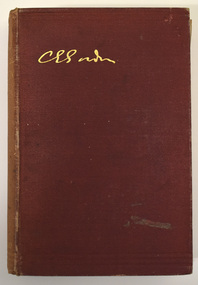 Warrnambool and District Historical Society Inc.
Book, The Journals of Major-Gen. C.G. Gordon, C.B. at Kartoum (sic), 1885
Journals of General Gordon of KhartoumThis is a book of 316 pages, plus 33 pages of information on other books for sale by the publisher.The book has a dark red cover with gold lettering on the front cover and the spine. The pages contain printed text, two maps, a portrait and thirty black and white illustrations.non-fictionJournals of General Gordon of Khartoumgeneral gordon of khartoum, gordon, kartoum -
 Glen Eira Historical Society
Pamphlet - St Margaret’s Church of England, Ripley Grove
A pamphlet with brief history of St Mary’s –St Margaret’s Caulfield 1860’s to 1948 written for parish dinner on 15/10/1957 by person unknown.st mary’s church, st margarets church, glen eira road, hood crescent, st clement, st agnes, st catherine, shelford, bluestone, clergy residences, bells, halls, sunday schools, schools -
Glen Eira Historical Society
Letter - St Margaret’s Church of England, Ripley Grove
Documents about the closure of this church. Correspondence to the St Margaret’s church congregation giving reasons why the church is not a viable asset to the particular are now from the Rev John W Wilson date 10/11/1987 Typed copy of annual financial report for the year ending Dec 1987 for St Margarets Anglican Church Caulfield Typed copy of St Margaret’s Anglican Church Caulfield 1988 Easter Edition for church closurest margaret’s anglican church, caulfield, ripley grove, prentice kw rev, st mary’s, st pauls, st agnes, st catherine, manses, wilson john rev, fillmore mr, gillespie d, tait mrs, lynch mr, giles mr, drovelson mrs, norton mr, davies mr, watson mr, black a, coulter marie mrs, gray pat, carpenter g, hosking bert, black ann, crabbe elsie, foster noel, nicholas norma, roberts freda, deyssing helen, prentice madge, fillmore wally, black dick, bates alice, bluestone, clergy residences, bells, sunday schools, schools, gillespie david, prentice madge l, norton bill, prentice kenneth w vicar, winwood mr, winwood mh mrs, baldwin er, organ, ralph bell mrs, penman jean mrs -
Glen Eira Historical Society
Ephemera - St. Mary’s Church, Caulfield
Two copies from St. Mary’s Anglican Church Caulfield, orders of service to celebrate Victoria’s 150th anniversary April 28, 1985. Four copies of pamphlet from St. Mary’s Anglican Church, Caulfield for The Joys of Living in Victoria, a festival of flowers and music dated April 25-28 1985. Included is a brief history from the 1850’s to 1985 of the church. Official opening leaflet with details of events and sponsors. The Joys of Living in Victoria, a festival of flowers and music order of service. Roneoed copy dated 25/04/1985.st. mary’s anglican church, caulfield, brooks r.c. rev., glasson william, organists, glen eira road, allen s. m. and sons, furniture stores, kennington laundry and drycleaners, drycleaners, glen huntly road, elsternwick, nepean highway, gardenvale, caulfield south, t. bathursts and co., funeral directors, ricks camera shop, elsternwick furnishing co., rothels pty. ltd., the sausage factory, four corners picture framing co., taylors the discount store, eight st. georges road, reception rooms, mane event hairdressing, fiskens pharmacy, boyd w. fox chemist, elsternwick travel world, mahony denis, hairline 309, hairdressers, madge tulloch florist, florist shops, michelson and associates, estate agents, port phillips press pty. ltd., printing industry, sommers jill, caulfield city choir, choirs, the tait-smith chamber group, tudor choristers, cathedral brass ensemble, trumble joan, brookes raymond rev., porter miss, park street, stephen george sir, hood crescent, bluestone, reid mr., architects, macartney mrs., st. mary’s church, st. stephen’s, gardenvale, st. clement, elsternwick, st. agnes, glenhuntly, glen huntly, st. catherine, caulfield, langley canon, shelford, green bishop, schools, helenslea, caulfield grammar school, davis j.h. rev., house names -
Glen Eira Historical Society
Document - St. Mary’s Church, Caulfield
Photocopied copy of Andrew Ward’s February 1994 conservation study he completed of St. Mary’s Church. Includes exterior and interior photograph. Two information leaflets on St. Mary’s Church of England and St. Mary’s Jubilee School, giving brief history of the church and hall. Includes sketches of church features.glen eira road, st. mary’s church, gothic architecture, bluestone, towers, bell, reed and barnes, stephen george sir, helenslea, jubilee school, schools, stained glass, bell towers, arches, roofs, bonham james, perry bishop, little and byrne, peck arthur, hood crescent, ward andrew, building construction, reid and barnes, cockram and co., moorehouse bishop, webb charles, goe bishop, shelford girls grammar school, architectural features, porches, bishops -
Glen Eira Historical Society
Document - Uniting Church Archives, Orrong Road, 78-66, Elsternwick
Five documents about the history of Elsternwick Methodist Church: 1/Two copy of the Centenary History of Orrong Road Uniting Church 14 November 1887-14 November 1987 by Norma Ward. Includes a list of Ministers, supernumeries and members of the male choir. 2/Handwritten updated history by N. Ward. 3/Roneoed copy of history of church by Betty Snowball dated 1978. 4/Caulfield Conservation study by Andrew Ward dated January 1995. 5/Printed extract of minutes dated 28/10/1927, 20/01/1928, 04/04/1928 and 07/06/1928. Details include the design of windows, placement in church, cost incurred of windows, the unveiling of windows, who by and appointment of committee to solicit donations to reduce debt reduction.methodist church, orrong road, elsternwick, snowball betty, foundation stones, campbell james, sunday school, halls, organs, leadlight, cato college, crouch t.j., architect, gothic revival architecture, bluestone, architectural features, mccallum alex, monuments and memorials, oakleigh arthur, stained glass, cato methodist ladies college, orrong road uniting church, cato parish, chapels, architects, crouch t.j., builders, ireland and newton, ward norma, religious structures and establishments, point nepean road, catterall john, daniel george, cook r. osborne, williams spencer, eggleston j., symons f., clergy, johns w.t., knuckey h.m., mitchells a.h., webster n.d.l., butcher t.w., cocks w.h., arthur g.t., warren j.e., williams r., hooper r.e., allen h.f., bennett m.m., walklate c.j., elliot n., hull j.e., chadwick r.j., roberts v., johnson l., coombe m., prior family, prisk family, mclaughlin family, searls family, bartrop family, orames fred, peverill family, brown family, crave e.s., bremer family, lambert family, grimwood family, kenny joe, wilson family, furlong family, oakley r. mck., holt vera, holt thelma, towans furniture removal, bouchier miss, trevena miss, matthews g.f., whitbourn m.j., penhallbrick family, searls beat, charlesworth albert, adams percy, leather tom, crone ted, hill herb, clubs and associations, staniland grove, beck family, rogers family, phillips family, kent family, kemp family, oakley family, bowden family, whiteside jack, bond family, beddoe bob, aston family, eddy r.d., marshman family, blackie family, kerr family, crellin family, towan family, curtis family, clarks, vivian george, lansell family, carmichael family, bright family, borcher family, albury family, cole family, semmens family, symons family, crowe e.s., hill bert, ward les., marriott jack, mcdonald malcolm, frost charles, macalese jack – entertainer ventriloquist, dunnachie frank, fletcher jack, gamley doug sen., old aubrey, gregory fred, roach family, grimwood family, hill frank, hill alan, sprott norm, guard w.h. rev., wellard ralph, bower wally, dunstan bert, hill herb, proctor keith – organist, gamley doug, slate tiles, rowan street, builders, jones and co., elsternwick uniting church – st. john’s, glenhuntly road, fijian assembly of god, victorian synod of the uniting church, plaques, memorials, mcoakley r. mrs., mcoakley r. mr., pensford mr., davies f.e. mr., brooks robinson and co., eddy r.d., whitborn m.j. mrs., whitborn g.f., tarah mr., arthur w. rev., biddoe mr., davies mr., crow mr. -
Glen Eira Historical Society
Letter - Kooyong Road, 415, Elsternwick
Two items about valuation of this property: 1/Typed letter dated 28/01/1977 from the Perpetual Executors and Trustees Association fo Australia Limited by Trust Officer RM Morrison to WV Scott of SP Simmond’s estate agents regarding the report and evaluation for the Sir Hugh Gerner Brian estate located at 415 Kooyong Road Elsternwick, included certificate of title. 2/Copy of typed letter by valuator WV Scott with details of the external and internal condition and valuation of the property with handwritten note,s dated 08/02/1977.kooyong road, elsternwick, brain hugh gerner sir, brain lady, land values, brick houses, bluestone -
Glen Eira Historical Society
Document - Roseneath, Nepean Highway, 31, Elsternwick
A photocopy of a Caulfield Conservation Study conducted in January 1995 by historian Andrew Ward of the house Roseneath named thus by 1904. The document includes a photocopied photograph of the front façade, although the features are unclear. The document, which includes a bibliography, details the history of Roseneath, including owners and occupiers, as well as the architectural features of significance and historical value.ward andrew, millar william, boyle andrew, worthington george, tulloch annie, cross anastasia, meek alex, caulfield, roseneath, elsternwick, nepean highway, mcmillan street, point nepean road, rusden street, cumbernauld, hawthorn road, glenmoore, st. georges road, caulfield south, shire of caulfield, east st. kilda riding, historic buildings register, national trust register, national estate register, italianate style, architectural styles, architectural features, mansions, brick houses, verandahs, cast iron work, bluestone, bay windows, land subdivisions, merchants, judges, leases, councillors -
Federation University Historical Collection
Book - Book - Scrapbook, Ballarat Institute of Advanced Education: Scrapbook of newspaper cutting. Book 1; December 1968 to August 1969
Newspaper cuttings relating to Ballarat Institute of Advanced Education. These are from various newspapers and include The Age, Ballarat Courier, The Australian, The Herald. The cuttings cover the period from 21 December 1968 to 12 August 1969. Book with grey cover, front. Spiral boundballarat institute of advanced education, biae, metallurgy scholarship awards, higher pay for academic staff, deep-sea housewife, jan watson, yendon bluestone for smb, building at mt helen, hepburn springs camp, cricket match, government may cut grants, quotas a must, apex scholarship to christopher dower, j m hasker of cement and concrete association, concrete course at smb, john stevens winner of gold medal, master plumbers' association, trade students prize night, education the answer, smb success depends on local support, $950000 expasion by smb, dr r schrieke, barry shearer, craftsmen receive awards, top swimmers, stephen yorke, ian ellis, apprentices on show, open night at smb, master builders' awards, first equipment at mt helen, craftsmanship awards, commonwealth must not control education, courses in computers, motor for trainee mechanics, bores under road, don skewes invents drill, bluestone blocks as terracing at smb, boost college intake, the lake relay, stuart alexander wins award, biae commands interest, ballarat gas company scholarships, smb on eve of new era, alan graham, r w richards medal, art in the sunshine, retirements from engineering firm, stan sweatman joins biae, smb diplomates in many fields, $130000 computer at biae, learning for living -
 Federation University Historical Collection
Photograph, Back Views of the Former Ballarat Supreme Court, 28/09/2020
The former Ballarat Supreme Court was renovated to become the Courthouse Theatre.Photograph of the rear of the Former Ballarat Supreme Courtballarat school of mines, former courthouse theatre, courthouse theatre, bluestone -
 Federation University Historical Collection
Photograph, Former Ballarat Gaol Gates, o4/2020
The former Ballarat Goal was transfered to the Ballarat School of Mines. Colour photographs of the gates at the former Ballarat Gaol. ballarat gaol, gaol gates, bluestone -
 Federation University Historical Collection
Photograph - Black and White Photograph, William Collard Smith's Colonial Land Office
Photograph of illiam Collard Smith's Colonial Land Office in Ballaratwilliam collard smith, colonial land, auctioneer, bluestone, ballarat -
 Mission to Seafarers Victoria
Photograph - Photograph, Black and white, Herald Sun, 18 May 1937
On 18 May 1937, Lord Huntingfield, Governor of Victoria (14 May 1934 – 4 April 1939) layed the foundation stone of the last of the missions built in Melbourne. The Mission to Seamen, Port Melbourne opened in December 1937, superceded the original 19th C building and service point in Port.Demolished in the late 20th C by developers the building was of architectural significance and funded originally by Alfred Nicholas who gifted 18,000 pounds. An indicator of the importance of shipping and seafarer welfare as regarded by Industry and business during the interwar years of the 1930s. This photograph is a record of the founding of the building. The stone is now part of the bluestone wall on Beach Road, Port Melbourne. The Mission was given the name: George V Memorial Institute, and the concert hall was given the name Huntingfield Hall.A black and white photograph depicting the laying of a foundation stone. Photograph of two clergymen standing to one side of the Governor of Victoria (1934-1939), Lord Huntingfield, who is holding a trowel in his left hand. A foundation stone, resting on a low brick wall is thought to be the granite foundation stone of the Port Melbourne Mission. A small crowd of approximately 21 people are gathered behind the wall. Back of photograph stamped, "Herald Feature Service Melbourne".port melbourne, beach road, lord huntingfield, art deco, alfred nicholas, foundation stone, trowel, harry a. norris, george v memorial institute, port melbourne mission, 1937 -
 Mortlake and District Historical Society
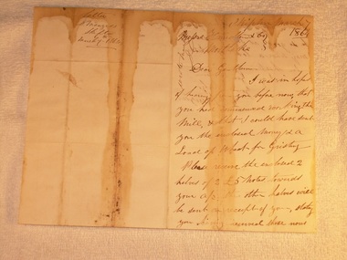
Letter for payment of account Mortlake Mill, March 7 1864
This letter was sent by a customer D. Menzies at Skipton to the Mortlake Mill, detailing an unusual payment method for the processing of his wheat into flour. David Menzies was a Scots farmer who lived in Skipton c. 1860's on a bend in the Mount Emu Creek. He helped establish the local school and a lane in the township bears his name. The letter illustrates the nature of commerce and the difficulties of communication and life generally in the country at the time. The bluestone Mortlake Mill built in 1856, has been a prominent landmark in Mortlake for over 150 years. It played a significant role in the commercial life of the town and was initially a wind-mill to process district grain for sale. The goldrush at Ararat 100 km. away led to a temporarily increased population and demand for foodstuffs. In 1857 the Mill was sold to Aikman, Hamilton and Geddes who converted it to steampower and later built the prominent chimney, which is on the Heritage Register as part of the National Estate. D. Menzies at Skipton lived at least 85 km away - his wheat which urgently needed milling, faced a slow and arduous journey by bullock dray. After the demise of the Ararat goldfields and the decline in population (as well as the district soils proving unsuitable for sustained wheat cultivation), the operation of the Mill declined too and the proprietors increased their involvement in other activities - supply of building materials, timber felling and sawmills. Despite the apparent difficulties of conducting business in the 1850's, it is notable that commerce thrived at that time in country districts, as an examination of Mill accounts and records show.Handwritten letter dated 1864 (water-stained)Skipton March 7 1864 [to] Messrs. Hamilton & Co. Mortlake. Dear Gentlemen, I was in hope of hearing from you before now that you had commenced working the Mill, & that I could have sent you the enclosed money [for a] load of wheat for Gristing. Please receive the enclosed 2 halves of 2 [two] 5 [pound sign] notes forwarded to your account. the other halves will be sent on receipt of your stating you having received those notes sent. As I am out of flour be so good as say how soon I may send a load of wheat. In haste I am Gentlemen Yours truly D. Menziesmortlake mill grain wheat hamilton geddes aikman laang dixie menzies skipton -
 Mortlake and District Historical Society
Mortlake Streetscape, Photograph, Late 19th Century
Intersection of Officer and Townsend Streets, Mortlake. Early street lamps and the telegraph line from Hexham to Mortlake Post & Telegraph Office in Shaw Street erected in 1862 are visible. Mount Shadwell Store purchased by A. S. Stewart in the mid 1880's from Clarke & Co. of Geelong. In this photograph one can see the previous two stores - the building in the centre would have been the original Store owned and built by the Rae & Robertson circa 1860 and sold to Grieve & Benn in 1862 - the bulding on the right hand side was the business premises of the Mount Shadwell Store owned by Grieve & Benn later used as a storeroom when the building on the right was erected by them to become the main business premises which John Grieve sold to Clarke & Co. of Geelong in 1882 and they to A. S. Stewart It still operates as a supermarket in 2011.Even though in 2011 a facade now covers the entire front of these three building, the original buildings are still within the fabric of the store and includes a cellar in front of the oldest building. Black and white photographmount shadwell store, bluestone buildings -
![Article and Photograph, Greensborough [Rose Series postcards], 2017_](/media/collectors/4f729f5697f83e03086015b8/items/5dd4a93b21ea6715f012648b/item-media/5dd4a96421ea6715f01297a9/item-fit-380x285.jpg) Greensborough Historical Society
Greensborough Historical SocietyArticle and Photograph, Greensborough [Rose Series postcards], 2017_
Photos of Greensborough taken from the Rose Series of postcards, posted by Helen White.This photograph and text was copied from a Facebook site. Members are people who lived in the Greensborough area and share their reminiscences of the area with others. The site is administered by a GHS member but is not officially affiliated with the Society. Any information is the opinion of the contributor. Article and photograph sourced from social media.greensborough, bluestone bridge greensborough, greensborough hotel -
 Greensborough Historical Society
Photograph - Digital image, Main Street Bridge Greensborough, 1910c
View of bridge over Plenty River at Greensborough. Photographs from the collection of Peter Blackbourn, a descendant of the Chapman Stock family. Annotations to photos by Peter Blackbourn.Digital copy of black and white or sepia photograph.peter blackbourn, main street greensborough, bluestone bridge -
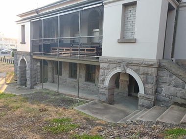
Glenelg Shire Council Cultural Collection
Photograph - Photograph - Burswood, Portland, n.d
Black and white photo. 'Burswood', front view, taken from garden on left.historic house, bluestone building -
 Greensborough Historical Society
Photographs, Greensborough Views, 1900c
Various views of Greensborough & district in the early 1900's.Records the houses, roads and bridge in Greensborough.2 copies of early Greensborough district photographs.Nilgreensborough, bluestone bridge, main street, aqueduct bridge, plenty river -
Marysville & District Historical Society
Booklet (Item) - Information booklet, The Big Culvert, Unknown
An information booklet that was produced as a guide to The Big Culvert.An information booklet that was produced as a guide to The Big Culvert. The Big Culvert is a historic granite and bluestone arch along the Yarra Track, a major route to Melbourne through the 1800s. Built in 1870 and a major piece of infrastructure for its time, the heritage listed culvert allowed water to flow under often-flooded the road. The Yarra Track is the former name of the gold fields road from Healesville to the Woods Point and Jordan Goldfields, in Victoria, Australia. A direct route via the Yarra River and the Great Divide was discovered by Rieck in September 1862 and became known as the Yarra Track. Early in 1863, the Victorian Government decided to construct a 193-kilometre (120 mile) road along the route. Its original width varied between 4 and 6 metres (12 and 20 feet), and was designed to accommodate horse-drawn vehicles. The Track involved the climbing of the Black Spur, descent into the Acheron Valley, and then through Marysville to the Cumberland where it followed the existing route.the big culvert, yarra track, victoria, healesville, wood's point goldfields, jordan goldfields, black spur, acheron valley, cumberland valley -
Marysville & District Historical Society
Flyer (Item) - Information flyer, The Big Culvert, 26-03-2016
An information flyer that was produced as a guide to The Big Culvert.An information flyer that was produced as a guide to The Big Culvert. The Big Culvert is a historic granite and bluestone arch along the Yarra Track, a major route to Melbourne through the 1800s. Built in 1870 and a major piece of infrastructure for its time, the heritage listed culvert allowed water to flow under often-flooded the road. The Yarra Track is the former name of the gold fields road from Healesville to the Woods Point and Jordan Goldfields, in Victoria, Australia. A direct route via the Yarra River and the Great Divide was discovered by Rieck in September 1862 and became known as the Yarra Track. Early in 1863, the Victorian Government decided to construct a 193-kilometre (120 mile) road along the route. Its original width varied between 4 and 6 metres (12 and 20 feet), and was designed to accommodate horse-drawn vehicles. The Track involved the climbing of the Black Spur, descent into the Acheron Valley, and then through Marysville to the Cumberland where it followed the existing route.the big culvert, yarra track, victoria, healesville, wood's point goldfields, jordan goldfields, black spur, acheron valley, cumberland valley -
 Marysville & District Historical Society
Photograph (Item) - Black and white photograph, Unknown
A black and white photograph taken at the unveiling of the sign placed at The Big Culvert.A black and white photograph taken at the unveiling of the sign placed at The Big Culvert. The Big Culvert is a historic granite and bluestone arch along the Yarra Track, a major route to Melbourne through the 1800s. Built in 1870 and a major piece of infrastructure for its time, the heritage listed culvert allowed water to flow under often-flooded the road. The Yarra Track is the former name of the gold fields road from Healesville to the Woods Point and Jordan Goldfields, in Victoria, Australia. A direct route via the Yarra River and the Great Divide was discovered by Rieck in September 1862 and became known as the Yarra Track. Early in 1863, the Victorian Government decided to construct a 193-kilometre (120 mile) road along the route. Its original width varied between 4 and 6 metres (12 and 20 feet), and was designed to accommodate horse-drawn vehicles. The Track involved the climbing of the Black Spur, descent into the Acheron Valley, and then through Marysville to the Cumberland where it followed the existing route.Unveiling of sign/ at "Big Culvert" In front Max Cockerrell and - Rear: second back Geoff Pope R.H.S. rear: Nancy "/ Anne "the big culvert, yarra track, victoria, healesville, wood's point goldfields, jordan goldfields, black spur, acheron valley, cumberland valley -
 Marysville & District Historical Society
Photograph (Item) - Colour photograph, 20-09-2008
A colour photograph of the entrance to The Big Culvert.A colour photograph of the entrance to The Big Culvert. The Big Culvert is a historic granite and bluestone arch along the Yarra Track, a major route to Melbourne through the 1800s. Built in 1870 and a major piece of infrastructure for its time, the heritage listed culvert allowed water to flow under often-flooded the road. The Yarra Track is the former name of the gold fields road from Healesville to the Woods Point and Jordan Goldfields, in Victoria, Australia. A direct route via the Yarra River and the Great Divide was discovered by Rieck in September 1862 and became known as the Yarra Track. Early in 1863, the Victorian Government decided to construct a 193-kilometre (120 mile) road along the route. Its original width varied between 4 and 6 metres (12 and 20 feet), and was designed to accommodate horse-drawn vehicles. The Track involved the climbing of the Black Spur, descent into the Acheron Valley, and then through Marysville to the Cumberland where it followed the existing route.the big culvert, yarra track, victoria, healesville, wood's point goldfields, jordan goldfields, black spur, acheron valley, cumberland valley -
 Marysville & District Historical Society
Booklet - Information booklet, Wilks Creek Bridge, 1993
A history of the Wilks Creek Bridge and its connection to the Yarra Track.Paperback. Front cover has an old photograph of the Wilks Creek Bridge.non-fictionA history of the Wilks Creek Bridge and its connection to the Yarra Track.wilks creek bridge, yarra track, narbethong, marysville, victoria, clement wilks, wood's point goldfields, jordan goldfields, john monash, monash and anderson, 2009 black saturday bushfires -
 Marysville & District Historical Society
Photograph (Item) - Colour photograph, Pre 2009
A colour photograph of the Wilks Creek Bridge near Marysville in Victoria.A colour photograph of the Wilks Creek Bridge near Marysville in Victoria. The Wilks Creek Bridge is a former timber and bluestone road bridge on the Yarra Track, and is located just off the Black Spur route, between Narbethong and Marysville, Victoria, Australia. It was built in 1870 to the design of colonial Public Works Department engineer Clement Wilks as part of the construction of a new road to the Woods Point and Jordan Goldfields. Like many bridges of the period, it had a timber superstructure employing squared beams supported by struts and straining pieces, on cut bluestone abutments. The bridge was remodelled around 1900 by engineer John Monash of the famous bridge-engineering firm of Monash and Anderson. It was last used for heavy vehicular traffic in 1980 following the realignment of Marysville Road, and was left to decay until its demolishment in 2008. All timber traces of the bridge were destroyed in the 2009 Black Saturday fires. The handcrafted bluestone masonry wingwalls and abutments, especially shaped to receive timber struts, rate among the earliest of its kind surviving intact in Victoria.wilks creek bridge, yarra track, narbethong, marysville, victoria, clement wilks, wood's point goldfields, jordan goldfields, john monash, monash and anderson, 2009 black saturday bushfires -
 Marysville & District Historical Society
Photograph (Item) - Black and white photograph, 1993
A black and white photograph taken at the re-opening of the Wilks Creek Bridge picnic area and launch of Ann Thomas' book Wilks Creek Bridge.A black and white photograph taken at the re-opening of the Wilks Creek Bridge picnic area and launch of Ann Thomas' book Wilks Creek Bridge. The Wilks Creek Bridge is a former timber and bluestone road bridge on the Yarra Track, and is located just off the Black Spur route, between Narbethong and Marysville, Victoria, Australia. It was built in 1870 to the design of colonial Public Works Department engineer Clement Wilks as part of the construction of a new road to the Woods Point and Jordan Goldfields. Like many bridges of the period, it had a timber superstructure employing squared beams supported by struts and straining pieces, on cut bluestone abutments. The bridge was remodelled around 1900 by engineer John Monash of the famous bridge-engineering firm of Monash and Anderson. It was last used for heavy vehicular traffic in 1980 following the realignment of Marysville Road, and was left to decay until its demolishment in 2008. All timber traces of the bridge were destroyed in the 2009 Black Saturday fires. The handcrafted bluestone masonry wingwalls and abutments, especially shaped to receive timber struts, rate among the earliest of its kind surviving intact in Victoria.wilks creek bridge, yarra track, narbethong, marysville, victoria, clement wilks, wood's point goldfields, jordan goldfields, john monash, monash and anderson, 2009 black saturday bushfires