Showing 8360 items matching "bridges"
-
 Eltham District Historical Society Inc
Photograph, Burkes Bridge, Hurstbridge
... bridges ...Colour photograph showing the old and new Burkes Bridges over Arthurs Creek, Hurstbridgeburkes bridges, bridges, hurstbridge, hurstbridge arthurs creek road, arthurs creek road, arthurs creek -
 Hume City Civic Collection
Photograph
... bridges ...A b/w photograph of the Macedon Street bridge over Jackson's Creek, with a car approaching.macedon street, bridges, jackson's creek, transport, sunbury, george evans collection -
 Phillip Island and District Historical Society Inc.
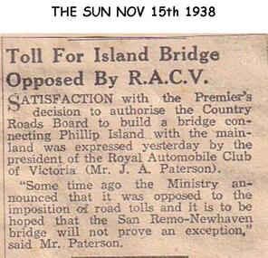
Newspaper clippings, 15/11/1938
... bridges ...Newspaper article in The SunArticle expressing opposition to tolls on Newhaven - San Remo Bridgelocal history, documents, newspapers, bridges, phillip island, tolls, black & white newspaper clipping, j a paterson president of racv -
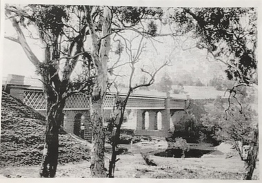 Kew Historical Society Inc
Photograph, Chandler Highway Bridge, 1930s
The railway viaduct linking the Outer Circle railway from Kew to Fairfield was constructed in the 1890s. In the 1930s it was converted into a motorway bridge.Photocopy of a photograph of the bridge linking Kew and Fairfield. Dated to the 1930s following the construction off the Chanler Highway.outer circle railway, viaduct (kew fairfield), john monash, chandler highway bridge -
 Port Melbourne Historical & Preservation Society
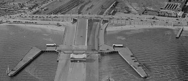
Photograph - Station Pier and surrounds c1940
It appears that there was some sort of event as there are many pedestrians and many vehicles on Centenary Bridge but very few on the pier. Circa 1940.Aerial photo approx 1940 showing Station Pier, Centenary Bridge, railyards and vehicles on Swallow St. piers and wharves - station pier, centenary bridge, transport - railways, swallow street -
 Lakes Entrance Historical Society
Postcard - Lakes Entrance from Jemmys Point, Bulmer H D, 1950c
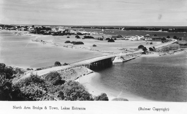
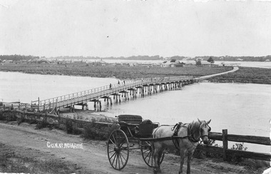
Township of Lakes Entrance from Jemmys PointColour tinted postcard of township showing bridge across North Arm; town buildings including Club Hotel, Methodist Church, Maranui Guest House; tower of Central Hotel; jetties in Cunninghame Arm, and sand dunes. Caravan parked beside concrete brick constructed toilet block opposite road to Bullock Island. Footbridge across Cunninghame Arm in distance, also lookout tower on Esplanade, and Life Saving tower over hummocks. Lakes Entrance VictoriaNorth Arm Bridge and Town, Lakes Entrancetownship, jetties, guesthouses, islands, hotels -
 Hume City Civic Collection
Photograph
The original swing bridge was built across the Deep Creek in 1854 to allow the Daniel family to visit the Dickens sisters. It was renewed in later years and was used by Bulla children until the school closed in 1995.A coloured photograph of the swing bridge which straddles the Deep Creek at Bulla. The photograph shows the full length of the wooden and wire bridge from bank to bank. There is a thick row of conifers growing along the opposite river bank.bulla swing bridge, deep creek, daniel family, bulla state school, george evans collection -
 Mt Dandenong & District Historical Society Inc.
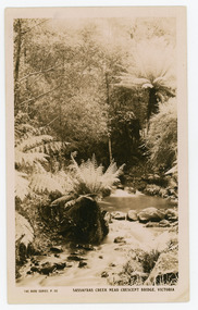
Photograph, Sassafras Creek Near Crescent Bridge. Victoria
Rose Series post card # P. 90. Sassafras Creek near The Crescent Bridge. View of water and ferns. Post 1920.Rose Series sepia coloured post card showing a small creek running through the centre of the photo edged by rocks and tree ferns.On front: The Rose Series, P. 90. SASSAFRAS CREEK NEAR CRESCENT BRIDGE. VICTORIA.sassafras creek, crescent bridge, creek, bridge, tree ferns, rose series, post card -
 Orbost & District Historical Society
black and white photographs, 1976 - 1977
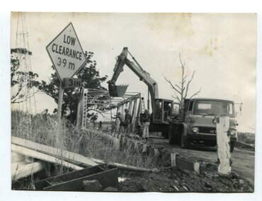
These photographs are of the demolition of the road bridge across the Snowy River at Orbost. This bridge over the Snowy River was opened on July 4 1922. It was constructed in 1922 alongside the previous suspension bridge. Its building was a combined effort of the Victorian Railways and the Country Roads Board at a cost of 35,000 pounds. It was replaced in 1976 by the present bridge after several major floods.This bridge was replaced in 1976 after several major floods. These photographs are pictorial records of its demolition.Four black / white photographs of the demolition of a road bridge across a river. In them can be seen trucks, excavators and workmen. In 3246.1 there is a triangular road sign - "LOW CLEARANCE 3.9m"bridge-demolition orbost-snwoy-river-bridge -
 Mission to Seafarers Victoria
Photograph - Photograph, Black and white
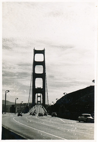
This photograph is part of series depicting Allan Quinn's travels through San Francisco in 1949. This photograph was taken while travelling across the Golden Gate Bridge.This is a photograph from the Allan Charles Quinn collection which is a collection of letters and photograph depicting aspects of life at sea for a young man in the era immediately following World War II.A black and white photograph of the Golden Gate Bridge, in San Francisco, dated 9-11-49.Reverse: 9-11-49 (handwritten in blue ink)/ K8 / B (handwritten side ways in pencil).allan-quinn, photograph, san-francisco, golden-gate-bridge, 1949 -
 Marysville & District Historical Society
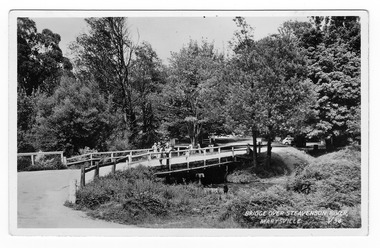
Postcard (Item) - Black and white postcard, Valentine Publishing Co. Pty. Ltd, BRIDGE OVER STEAVENSON RIVER, MARYSVILLE. V.34, 1923-1963
A black and white photograph of a bridge over the Steavenson River in Marysville in Victoria.A black and white photograph of a bridge over the Steavenson River in Marysville in Victoria. The Steavenson River is named after the Victorian Assistant Commissioner of Roads and Bridges, John Steavenson who arrived in Victoria in the early 1860s. This postcard was produced by Valentine Publishing Co Pty. Ltd. as a souvenir of Marysville.VALENTINE'S POST CARD A GENUINE PHOTOGRAPH 1940marysville, victoria, steavenson river, valentine publishing co, postcard, souvenir, john steavenson -
 Chelsea & District Historical Society Inc
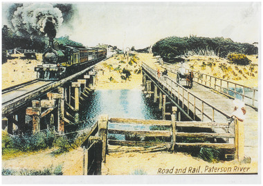
Photograph - Patterson River Postcards, Rail and Road Bridge, c 1905
The first bridge over the river was built in the early 1880's, prior to this it was a pontoon bridge. Dr. Sheldon's Magnetic Liniment was advertised as being able to relieve "at once rheumatism, lumbago, lame back, cuts, bruises or burns, will effect a cure in a remarkably short time. Price 1s 6d and 3s"Two postcards of the road bridge (Nepean Highway) with a horse and cart and people crossing and single line rail bridge , with a steam train crossing over Patterson River, near the mouth of the river. One card has been coloured, the other has been modified to advertise Dr Sheldon's Magnetic Liniment.DR SHELDON'S NEW DISCOVERY 16' & 3' BANISHES ALL PAINS AT CARRUM VICTORIApatterson river, road bridge, rail bridge, dr sheldon's linament, chelsea, steam train, transport, chelsea bridge, patterson bridge -
 Lakes Entrance Historical Society
Postcard - North Arm bridge. Lakes Entrance Victoria c1900, Cooper Alexander, 1900c
... Bridges ...CunninghameSepia coloured postcard of first bridge over North Arm, showing view of town buildings, including Club Hotel; sand hummocks; Cunninghame Arm; die back of melaleuca on sand flats. In foreground post and rail fence beside road, two wheeled horse drawn vehicle, jinker, with grey horse standing in shafts. Ten or eleven people standing on bridge. Lakes Entrance Victoriatopography, bridges, transport -
 Wodonga & District Historical Society Inc
Photograph - Bethanga Bridge
The Bethanga Bridge was built between 1927 and 1930 as a joint venture between Victoria and New South Wales and was a key element of the River Murray Waters Agreement. It consists of nine spans of 82 metres long. Each span is supported between double reinforced concrete pylons and a riveted steel camel back Pratt truss. The overall span of the bridge is a length of 752 metres. It was completed in 1929 at a cost of £194,000. The road deck was initially constructed from timber but was replaced in 1961 with a concrete waffle slab deck 7.7metres wide. In 1961 the bridge deck and truss structure were raised 300 millimetres to allow for the enlargement of the lake. The bridge was designed in NSW by road engineer Percy Alan and the trusses were built by the Charles Ruwolt Pty. Ltd. Charles Ruwolt Pty. Ltd. was originally established by Charles Ruwolt as a foundry at Wangaratta in 1902 and transferred its operations to Richmond, Melbourne in 1914. By 1938 it had become one of the biggest engineering companies in Australia. After Charles Ruwolt’s death in 1946, Vickers Ltd. acquired the company and in 1948 the firm became known as Vickers Ruwolt Pty. Ltd. Because of the Bethanga Bridge’s unique location, over the waters of a dam with the border running down the centre of the body of water, the Bethanga Bridge is the only built structure shared by both Victoria and New South Wales. As the border of New South Wales aligns with the southern bank of the Murray River all of the other bridges along its length are deemed to be in New South Wales. The Bethanga Bridge is listed on both the New South Wales State Heritage Register and the Victorian Heritage Database. In 2015 the Bethanga Bridge was nominated for a heritage award by the Institution of Engineering Australia.These images are significant because they document the construction of a bridge which links Victoria and New South Wales and has been recognised for its historical, technical and engineering significance.A collection of photos documenting the construction of the Bethanga Bridge which links the States of Victoria and New South Wales as part of the construction of the Hume Dam .bethanga bridge, hume dam constuction, charles ruwolt, percy allan engineer -
 Marysville & District Historical Society
Photograph (item) - Colour photograph, 31-12-2008
A digital copy of a colour photograph of the timber tramway bridge along the Michaeldene Walking Track near Marysville in Victoria.A digital copy of a colour photograph of the timber tramway bridge along the Michaeldene Walking Track near Marysville in Victoria. The Michaeldene Trail to Taggerty River Lookout is a 4.3 kilometer lightly trafficked loop trail located near Marysville, Victoria. The track is one of several walking tracks located in and around Marysville in Victoria.timber tramway, michaeldene walking track, marysville, victoria, walking track -
 Marysville & District Historical Society
Photograph (item) - Colour photograph, 20-09-2008
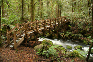
A colour photograph of a wooden bridge over the Taggerty River that is part of the Beeches Rainforest Walk near Marysville in Victoria.A colour photograph of the Beeches Rainforest Walking Track near Marysville in Victoria. Starting from the spectacular Taggerty Cascades, the Beeches Rainforest Walk meanders through the ancient cool temperate rainforest of the Yarra Ranges. Dominated by Myrtle Beech trees and stands of Mountain Ash, it is home to the lyrebird which live on the forest floor.beeches rainforest walking track, marysville, victoria, taggerty river, taggerty cascades, yarra ranges, myrtle beech, mountain ash, lyrebird -
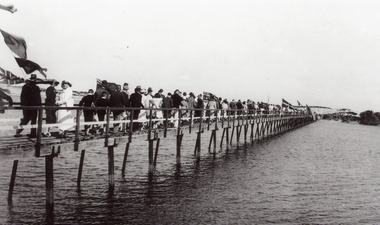 Lakes Entrance Historical Society
Photograph - Footbridge, 1927
... Bridges ...Official opening 27 March 1927Black and white photograph of the footbridge over the Cunninghame Arm, showing a crowd of people following the Melbourne Lifesavers crossing the bridge after the official opening, Lakes Entrance Victoriawaterfront, bridges, celebration -
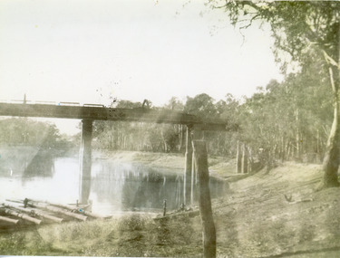 Lakes Entrance Historical Society
Photograph, 1940
... Bridges ...Black and white photograph of a railway bridge over waterway on railway line at unknown location. Boat at edge of water has small load of log timbers across it. Victoriabridges, transport, vegetation -
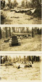 Lakes Entrance Historical Society
Photograph - Foundation piles for Swan Reach Bridge, Country Roads Board, 1925 c
... Bridges ...Black and white photographs of preparation for construction of the Swan Reach bridge showing five large piles cut at the CRB timber coup at Won Wron South Gippsland Victoriabridges, construction, machinery -
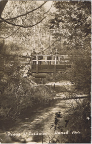 Cockatoo History & Heritage Group
Postcard, Barratt Photo of Men on McBride St Bridge Cockatoo
An early Barratt photo of the Cockatoo Creek, looking towards the McBride St bridge. The four men depicted in the image, look relaxed and are taking in the serenity of the creek below.Dear Florrie, just a card to let you know I haven't quite ? altogether am up here among the ferns and ? It is a lovely place for a quiet holiday the fern gullys are just lovely you can see the Ranges in the distance as blue as the sea. This view is the bridge over Cockatoo creek near the R. Station. As space is short I will close Best Love from ?Original Barratt Photo, of four men standing on the McBride St bridge over the Cockatoo CreekRear of the postcard includes handwritten correspondence in ink, to someone called Florriea. t barratt, postcard, cockatoo creek, cockatoo, views of cockatoo, -
 The Beechworth Burke Museum
Photograph
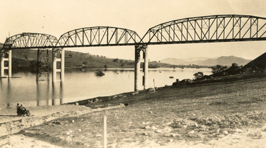
Taken between 1928 and 1930, depicted is the Bethanga Bridge under construction. The Bridge was completed in 1930 and was built to assist residents of the Bethanga district to travel to Albury. Other bridges would become submerged by the backed-up water of the Murray and Mitta Rivers so the Bethanga bridge was built two miles above the Mitta Weir. The Bethanga Bridge was built north of the future Hume Dam which would be completed in 1936. At 2430 feet long, Bethanga Bridge was the longest road bridge in Australia at the time of its completion. The Bridge is 20 feet wide and made up of nine 270 feet long spans. Materials used include ten tons of paint for the steel works; 1600 tons of steel; 900 tons of timber for the decking; and reinforced concrete for the piers. The tender for the construction was awarded to C. Ruwolt Pty. Ltd., engineers who were located on Victoria Street, West Richmond. The contract was awarded for £71,890. It was predicted between 250 and 300 men would find employment on the project. The news was well received by trade unions at the time as there had been a drop in available engineering work.This photograph is historically significant as it depicts the progress of the Bethanga Bridge construction, which was important infrastructure for the area. It is also a good example of methods used in the area to assist in travel over the river prior to the construction of the Hume Dam.Black and white rectangular photo printed on matte photographic paper.Reverse: 1997 3186 / 84-19-3 / This is the bridge. / It is not yet open to traffic / yet. will not be completed / until May next / It is a wonderful bridge the / pillars are 100 feet high. / KODAK PRINT Envelope Obverse: Peterson PHOTO / Hume Weir Envelope Reverse: BMM 84-20-1,2+3. bethanga bridge, lake hume, hume dam, hume weir, murray river, bridge, bethanga, albury -
 Clunes Museum
Photograph
... bridges ...C.T.D.A. PREDIDENT, FRANK COLLINS AND UNKNOWN PERSON DURING OPENING OF SUSPENSION BRIDGE OVER CRESWICK CREEK CLUNES. 14/4/1986.local history, photography, photographs, bridges -
 Phillip Island and District Historical Society Inc.
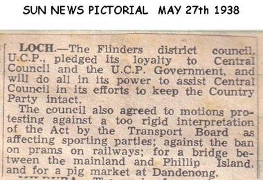
Newspaper clippings, 27/05/1938
... bridges ...Article in Sun News PictorialArticle about V.C.P. Government and Transport Board Act and bridge between Phillip Island and The Mainland.local history, documents, newspapers, bridges, phillip island, black & white newspaper clipping -
 Phillip Island and District Historical Society Inc.
Publication, 1970
... Bridges ...Publication donated by S. J. McFeePublication by S. J. McFee on the history of the first Phillip Island Bridge, first published 1970.local history, documents, publications civil engineering, bridges, history of the phillip island bridge, phillip island bridges -
 Charlton Golden Grains Museum Inc
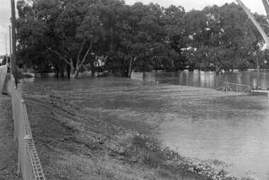
Photograph, Cameron, Ian, 1973 flooded Avoca River, Feb 19873
1973 flooded Avoca River. Viewed from west side of Paterson Bridge behind the shire office.B/W photograph of 1973 flooded Avoca River. View West side of Paterson Bridge behind Shire Officeflood, avoca river, charlton -
 Marysville & District Historical Society
Photograph (Item) - Black and white photograph, Bridge Over The Cumberland, c1900
An early black and white photograph of a bridge over the Cumberland Creek near Marysville in Victoria.An early black and white photograph of a bridge over the Cumberland Creek near Marysville in Victoria. The Cumberland Creek is in the Cumberland Valley near Cambarville which was a timber town near Marysville. Cambarville is notable for its giant mountain ash (Eucalyptus regnans) trees within the Cumberland Memorial Scenic Reserve, and relics from former sawmills and gold mining. The Big Culvert is located nearby on the Marysville - Woods Point Road, which was historically part of the Yarra Track. Cambarville was established as a timber mill town in the 1940s. Timber mill owners A Cameron and FJ Barton named Cambarville. They established the mill to salvage timber from trees destroyed in the 1939 bushfires. Cambarville was impacted by the 2009 Black Saturday bushfires and any remaining structures were destroyed.ARMSTRONG COLLECTION 42 STATION STREET/ SANDRINGHAM 3191/ TEL. (03) 9521 5442/ IAN M.L. ARMSTRONG OAMcumberland creek, marysville, victoria, cumberland valley, cambarville, mountain ash, eucalyptus regnans, cumberland memorial reserve, the big culvert, marysville-wood's point road, yarra track, a cameron, fj barton, 2009 black saturday bushfires -
 Stawell Historical Society Inc
Book, P. Van Diesen, Tobacco Growing in Dadswells Bridge, 1991
History Option H.3.C. Tobacco Industry at Dadwells Bridge Contains various photographs.Clear Plastic cover with dark blue edge. on Plastic History Option P. Van Diesen. On Paper underneath cover Tobacco Growing in Dadswell Bridgestawell farming -
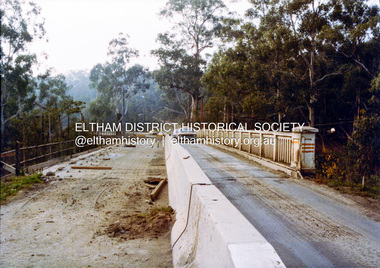 Eltham District Historical Society Inc
Photograph, Ruth H. Pendavingh, Widening of Main Road Bridge over the Diamond Creek, Eltham, 1984c
... bridges ...Three colour photographs of the construction work of the widening works of the bridge over the Diamond Creek, Eltham, near Lower Eltham Park Victoria. The bridge re-opened on October 25, 1984. (EDHS Chronology of known local events 1835- early 2000) eltham, main road, main road bridge, bridges, construction, diamond creek (river)