Showing 26591 items
matching buchan-river-view-hotel
-
 Stawell Historical Society Inc
Slide, Ian McCann, Wimmera River Bridge at Joel 1957, 1957
Wimmer River Bridge at Joel 1957wimmera river, joel area, joel bridge -
 Ballarat Heritage Services
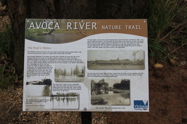
Photograph - Colour, Avoca River Interpretation Panel, 2011, 06/08/2011
Photograph of an interpretive panel on the Avoca River.avoca, avoca river -
 Tarnagulla History Archive
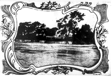
Photographs: Loddon River, Newbridge after flood, Loddon River, Newbridge after flood, 1909 (original image)
On 20th August,1909 the Laanecoorie Weir broke away and released 18.3 million cubic metres of water through the opening and causing severe damage to all towns downstream. At Newbridge, Petersen's bakery collapsed and Simpson's Store and Hotel flooded to the roof. The billiard table was later found in a tree five miles down the Loddon near Learmonth. Murray Comrie Collection. Two copies of a monochrome photograph, image part of damaged bridge in the area near Loddon River at Newbridge after major flood in 1909. This is a very grainy and dark copy of an older original. Copy probably made by Murray Comrie in the 1960s.newbridge, loddon river, flood, bridge -
 Ballarat Heritage Services
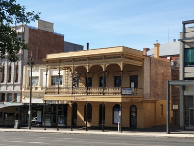
Photograph, Unicorn Hotel, Sturt Street, Ballarat, 2020
This photograph was taken during hte covid19 lockdown.Photograph of a double storeyed hotel in Sturt Street Ballarat known as the Unicorn Hotel.unicorn hotel, ballarat, sturt street, covid19 -
 Lakes Entrance Historical Society
Photograph, G Legg Bairnsdale, Tambo River, Tambo Upper Victoria, 1970 1980 c
Black and white photograph of Tambo River, Tambo Upper Victoria. Also a black and white photograph of flood in the Tambo River location not identified rivers, topography, farming -
 Marysville & District Historical Society
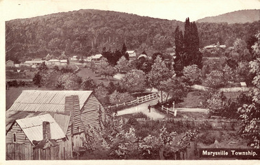
Postcard (item) - Black and white postcard, Marysville Township, 1936
A digital copy of a black and white postcard of the view of the Marysville township taken from the Steavenson Hotel.A digital copy of a black and white postcard of the view of the Marysville township taken from the Steavenson Hotel.marysville, victoria, australia, steavenson hotel, poontawan, marysville chalet, george wright, pack road, wood's point road, wood's point mountaineer, albion restaurant, steavenson's creek, yarra track, bridge inn, butler's woods point general directory 1866, postcard -
 Glenelg Shire Council Cultural Collection
Photograph - Photograph - Killara Bridge over Glenelg River, c. 1963
Sourced from Casterton Town Hall (former Shire of Glenelg)Black and white photo. View of Killara Bridge over Glenelg RiverFront: Black stamp - 003635 Back: 'View of Killara Bridge over Glenelg River' - handwritten in pencil. Blue biro line arrowed both ends, drawn across width of photo. 3" in blue biro written above line -
 University of Melbourne, Burnley Campus Archives
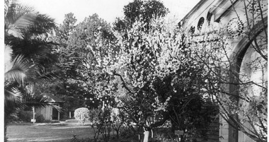
Photograph - Black and white print, View Across Lawn to Summer House, 1942-1946
Possibly from J.L. Provan's photograph collection. Note by T.H. Kneen 8 April 1992, "View is from Botany room entry, east of main entry to Pavilion."Black and white photograph. View from corner of the Pavilion towards the Summer House. Tree in blossom in the foreground.j.l. provan, botany room, pavilion, garden view, summer house, shelter shed, blossom tree -
 Warrnambool and District Historical Society Inc.
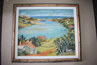
Framed Paintings, 1 The Frame Shop, Fairfield, Melbourne .2 Kardinia Picture Framing, Geelong, 1Warrnambool Botanical Gardens .2 Hopkins River, Warrnambool, 1953
These two works of art are by Dr Don Edgar, a sociologist, educator and author. He taught sociology at Stanford University, the University of Chicago, Monash University and La Trobe University and was the founding Director of the Australian Institute of Family Studies. In the 1950s Dr Edgar was a student at Warrnambool High School and these works of art were produced at that time. For a school project he researched the early history of the Warrnambool Art Gallery and some of its collection, dating from the 19th century. In 2019 he published a book, ‘Art For the Country’, the story of Victoria’s regional art galleries and the book includes information on the founding and the later history of the Warrnambool Art Gallery.These works of art are of interest as they were painted by Dr Don Edgar, a noted academic and author today and a former resident of Warrnambool. The two works of art also have historical interest as they depict Warrnambool scenes painted over 60 years ago. .1 An art work (oil on artboard) – the Warrnambool Botanical Gardens with bridge and reflections, a gum tree and a poplar tree, all in green and orange tonings. The wooden frame has a light varnish with gold and white trim .2 An art work (oil on artboard) – multi-coloured view of the mouth of Hopkins River with the Hopkins River bridge, Lyndoch bungalow and boathouse. The frame is wooden with a mottled varnish and a white insert edging. .1 Don Edgar 1953 Don Edgar 1953 (High School Student) .2 D.E. 53 Don Edgar 1953 (High School Student) dr don edgar, sociologist, author and educator, warrnambool art gallery, history of warrnambool -
 Linton and District Historical Society Inc
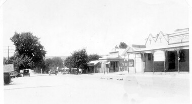
Photograph, Sussex Street, Linton - view to north, late 1920s or early 1930s
Dated to late 1920s or early 1930s as Nelson building has been renovated as a Californian bungalow. The earlier curvilinear parapet on the library building (see photo - Registration no. 166) has been squared off, and a small pedimented timber parapet has been added above.Black and white photograph of Linton's main street, Sussex Street. View of Railway Hotel, Nelson undertaker building, public library and "cash emporium". Cars parked and driving along Sussex St."Linton Main Street".sussex street linton, railway hotel, nelson undertakers, linton public library, cash emporium, transport, cars -
 Stawell Historical Society Inc
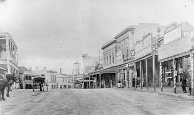
Photograph, Upper Main Street Stawell looking East with on left the 2 story Allingham building & behind the cart is the Commercial Hotel c1910 -- 2 Photos -- 1 Colour
Upper Main Street Stawell. Looking East c1910. On left two story Allingham building behind cart is Commercial Hotel. Oriental Bank. Punchard Furniture. Crown Cross Poppet head visible on Big Hill. The side of the Mechanics Institute visible near centre. H S Dawson Chemist. Clarke & Scott Drapery on right. Same as 6730-1 & 2785View along upper Main Street looking East towards Big Hill. Poppet Head in distance at centre.stawell streetscape, mining -
 National Vietnam Veterans Museum (NVVM)
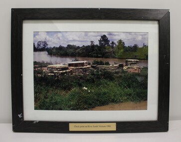
Photograph - Check Point on River South Vietnam 1968
This item commemorates the war in Vietnam ( 1962 - 1972)A colour photograph of a check point in South Vietnam in 1968.Check point on river South Vietnam 1968.south vietham, 1968, exon -
 Port Fairy Historical Society Museum and Archives
Photograph
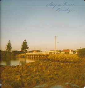
Moyne River Bridge 1970's North sideColoured photograph of Moyne river traffic bridge taken from the North side on the West bankMoyne River Bridge- on frontmoyne river, bridge, west side -
 Marysville & District Historical Society
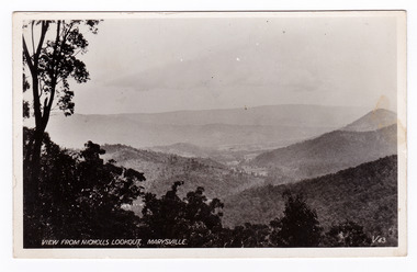
Postcard (item) - Black and white postcard, Valentine Publishing Co. Pty. Ltd, View From Nicholl's Lookout, Marysville. V. 43, 1923-1963
An early black and white photograph of the view of Marysville in Victoria taken from Nicholl's Lookout.An early black and white photograph of the view of Marysville in Victoria taken from Nicholl's Lookout. This lookout is situated on the Marysville-Wood's Point Road. The Marysville-Woods Point Road was originally part of the Yarra Track, constructed in the early 1860s to provide access between Healesville and the Woods Point Goldfields. Despite the steep terrain and engineering difficulties, the Yarra Track soon became a busy route used by pack horses, horse-drawn drays, and wagons. Today this sealed mountain road is a popular scenic drive between Marysville and Warburton. This postcard was published by the Valentine Publishing Co Pty. Ltd. as a souvenir of Marysville.VALENTINE'S/ POST CARD/ A GENUINE PHOTOGRAPHmarysville, nicholl's lookout, victoria, postcard, valentine publishing co, souvenir -
 Hume City Civic Collection
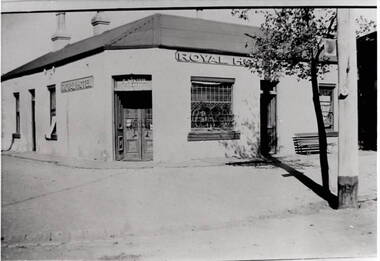
Photograph, Royal Hotel
This is an image of the original single storey Royal Hotel building which was on the corner of Brook and Evans Streets. In the 1930s the single storey structure was demolished after a fire and replaced with a double storey Art Deco red brick building, which still stands on the same site.At one stage there were four hotels in Evans Street between Station Street and Brook Street. At some stage the Millett family owned them. The Royal and the Olive Tree (formerly the Railway) hotels remain on their original site but not in their original appearance.A black and white photograph with a cream border of a single storey hotel building with a headlight window on the RHS of the corner entry doorway, which also has lead light windows. A young tree and power pole are seen on the RHS of the image. hotels, royal hotel, s.winter, t. millett -
 Stawell Historical Society Inc
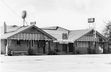
Photograph, Great Western Hotel formerly the Shakespeare Hotel 1991
Great Western Hotel formerly the Shakespeare Hotel 1991great western -
 Orbost & District Historical Society
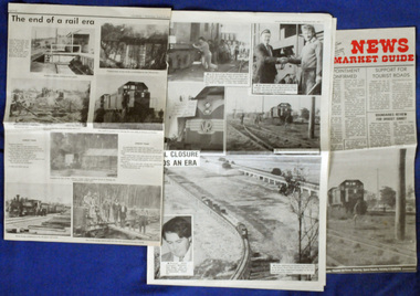
newspaper clippings, August, September 1987
The Bairnsdale-Orbost railway was opened in 1916 to serve the agricultural and timber industry. Because of the decline in traffic and heavy operating costs, the line was finally closed in August, 1987. The closure of this railway was a controversial issue at the time with many public protests in the district. These articles are contemporary record of a significant event in Orbost history.Three articles relating to the closure of the Bairnsdale - Orbost Railway in 1987. They are from the Snowy River Mail and The News. They contain photographs, news articles and the history of the line and its closure. orbost-bairnsdale-railway east-gippsland-railway snowy-river-mail -
 Flagstaff Hill Maritime Museum and Village
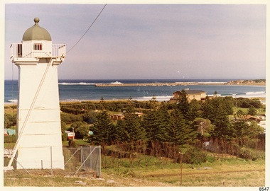
Photograph - Historical, Flagstaff Hill, John Lindsay, View of the Bay from the south boundary of the Ports and Harbours land, 1970s
The photograph shows the view of the shore and Lady Bay with the Breakwater and Middle Island all visible. It was taken to show that the Flagstaff Hill area was unlikely to have any further development between it and the Bay, with the view of development of the Flagstaff Hill Maritime Museum and Village. This photograph, a print, is one of a set of five that show the site of Flagstaff Hill. The photographer was John Lindsay, Founding Director of Flagstaff Hill Maritime Museum and Village, with the words "Photo J Lindsay" on the back. It was taken in the early 1970s during the initial stages of the development of Flagstaff Hill as a Museum and Maritime Village. The photographs belonged to the donor's grandparents, who lived in the Warrnambool district of Allansford/Naringal. The photograph is a record of the site and surrounds of Flagstaff Hill Maritime Museum and Village before its development and opening in 1975. It shows the Surfside Holiday Park, Surf Lifesaving Club, and the Breakwater. The photograph is significant for recording the location and condition of the Lower Lighthouse on the Hill.Coloured photograph, glassy print, one of a set of five. Flagstaff Hill's Lower Lighthouse is in the foreground above the Surfside Holiday Park. To the right of centre is the Surf Lifesaving Club. In the background is Lady Bay and the Breakwater and Middle Island, with the Southern Ocean the other side. The photograph's paper has the printer's watermark and a pencilled inscription on the back. The early 1970s scene was photographed by John Lindsay, Warrnambool.Label on the back: "VIEW OF THE BAY FROM the southern boundary of the Ports and Harbours land. No development below this area is likely to obstruct the view, due to the steep grade down to the Southern boundary of Flagstaff Hill property." Handwritten in pencil: "Photo J Lindsay"flagstaff hill, flagstaff hill maritime museum and village, warrnambool, maritime museum, maritime village, great ocean road, shipwreck coast, 1970s, photograph, surfside holiday park, lady bay, flagstaff hill site, john lindsay, lower lighthouse, lower light, surf lifesaving club, breakwater, middle island, ports and harbours -
 Marysville & District Historical Society
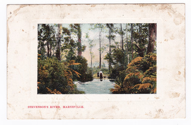
Postcard (item) - Colour postcard, Nicholas John Caire, Stevenson's River, Marysville, 1858-1918
One of a series of postcards of photographs taken by socialite photographer Nicholas John Caire.One of a series of postcards of photographs taken by socialite photographer Nicholas John Caire. N.J. Caire had a great love for the area and in the late 1800's took many photographs of Marysville and its surrounds.POST CARD. THIS SPACE FOR CORRESPONDENCE THE ADDRESS ONLY HERE PLACE/ POSTAGE/ STAMP/ HERE.steavenson river, stevenson's river, nicholas john caire, marysville, victoria, postcard, souvenir -
 Ringwood and District Historical Society
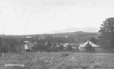
Photograph, View over Ringwood from Heatherdale Road
Black and white photograph (2 copies)Typed below photograph: "View over Ringwood from Heatherdale Road. Note Maroondah Highway on left and Coach and Horses Hotel at end near bend and coolstores beyond that c1930." -
![View of Sailor’s Creek Bridge / [by] Nicholas Caire, circa 1876](/media/collectors/550653872162f11fb04854aa/items/577b5b7ed0cdd10948d14ae1/item-media/577b5be9d0cdd10948d196a2/item-fit-380x285.jpg) Kew Historical Society Inc
Kew Historical Society IncPhotograph, Anglo-Australasian Photographic Company, View of Sailor’s Creek Bridge, c.1876
Nicholas Caire was born on Guernsey in the Channel Islands in 1837. He arrived in Adelaide with his parents in about 1860. In 1867, following photographic journeys in Gippsland, he opened a studio in Adelaide. From 1870 to 1876 he lived and worked in Talbot in Central Victoria. In 1876 he purchased T. F. Chuck's studios in the Royal Arcade Melbourne. In 1885, following the introduction of dry plate photography, he began a series of landscape series, which were commercially successful. As a photographer, he travelled extensively through Victoria, photographing places few of his contemporaries had previously seen. He died in 1918. Reference: Jack Cato, 'Caire, Nicholas John (1837–1918)', Australian Dictionary of Biography.An original, rare photograph from the series 'Views of Victoria: General Series' by the photographer, Nicholas Caire (1837-1918). The series of 60 photographs that comprise the series was issued c. 1876 and reinforced a neo-Romantic view of the Australian landscape to which a growing nationalist movement would respond. Nicholas Caire was active as a photographer in Australia from 1858 until his death in 1918. His vision of the Australian bush and pioneer life had a counterpart in the works of Henry Lawson and other nationalist poets, authors and painters.Views of Victoria (General Series) No.31 / ‘View of Sailor’s Creek Bridge’ / Albumen silver photograph mounted on boardOn Reverse" ‘Sailor’s Creek as situated in the Jim Crow Ranges, which Range forms a portion of the Great Dividing Range of Mountains in Victoria. These hills contain many romantic spots. The one which forms the subject of the present illustration is a view of the Bridge which spans the Creek. Gold has been found throughout the course of the bed of this Creek in payable quantities. The diggers, as may be seen in the photograph, have constructed sluices in the side of the embankment for the purpose of washing the fine gold contained in the wash-dirt.’nicholas caire (1837-1918), sailor's creek (vic), gold mining (vic) -
 Wodonga & District Historical Society Inc
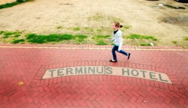
Photograph - Terminus Hotel footpath inlay
During the depression of the early 1930s, men on the dole carried out work for the Wodonga Shire Council. One of the projects during the term of councillor Mick Martin, as shire president, was to seal the footpaths in central Wodonga. Local business people supplied the cement. The police department refused to fund the cement for its section of High Street, north of the railway line, which included the police station and the courthouse. The then licensee of the Terminus Hotel offered to provide the cement for sealing the footpath in front of the police station and courthouse. This offer was made on the condition that tiles bearing the words Terminus Hotel be inserted into the footpath pointing toward the hotel.The police objected but the hotel licensee, Tex Bailey, won the day. As a result, his hotel’s tiled name was inserted into the footpath in front of the police station. Cr Mick Martin’s son, Des, wrote to the council in 1967 asking that the sign be preserved and it was moved to the Terminus Hotel and placed in the footpath there.The Terminus Hotel was one of the earliest hotels in Wodonga with clear links to the establishment of the railway line. It was an important business and meeting place for social gatherings.The name, Terminus Hotel worked into the brickwork of the footpath when they were surfaced by sustenance workers during the 1930s Depression. "TERMINUS HOTEL"hotels wodonga, businesses wodonga, terminus hotel wodonga -
 Ballarat Heritage Services
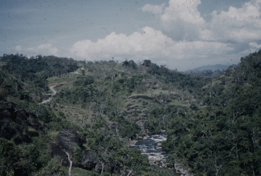
Slide, Dorothy Wickham, Loloki River, Sogeri Road, Papua New Guinea, 1958
This photograph was taken around 1958.Scanned from a coloured slideView from this sidepapua new guinea, port moresby, papuans, girl guides, dorothy kinnane, sogeri -
 Ballarat Heritage Services
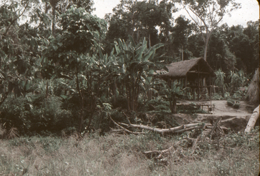
Slide, Dorothy Wickham, Hut, Brown River Road, Papua New Guinea, 1958
Scanned from a coloured slideView from this sidepapua new guinea, papuan, brown river road, hut, thatch -
 Greensborough Historical Society
Photograph - Digital image, Marilyn Smith, Plenty River bank stabilisation 2015; river bank, 16/08/2015
River bank stabilisation project along the Plenty River at Greensborough 2015, conducted by Melbourne Water. This photo shows the river bank in Greensborough.Digital copy of colour photographplenty river, melbourne water -
 Ballarat Heritage Services
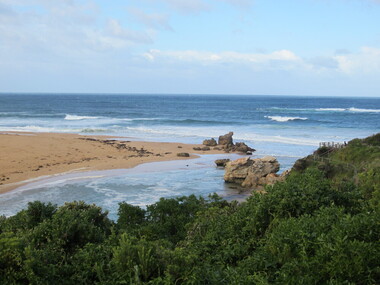
Photograph - Colour, Mouth of the Hopkins River, Warrnambool, 2012, 18/08/2012
Colour photographs of the mouth of the Hopkins River at Warrnambool.warrnambool, hopkins river, mouth, sea -
 Ballarat Heritage Services
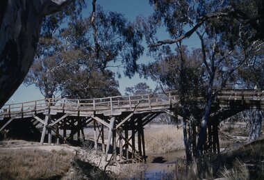
Photograph, Lisa Gervasoni, Bridge over the Avoca River, Victoria, 2011, 06/08/2011
Colour photographs of a bridge over the Avoca Riveravoca, avoca river, pre olympic swimming pool -
Ballarat Heritage Services
Photograph, River Boats Below Murray Bridge, South Australia
River Boats on Murray Bridge, South Australia.river boats, murray bridge, south australia -
 Ballarat Heritage Services
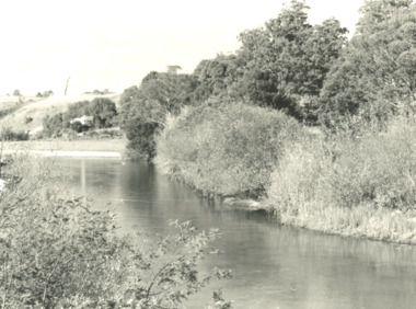
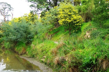
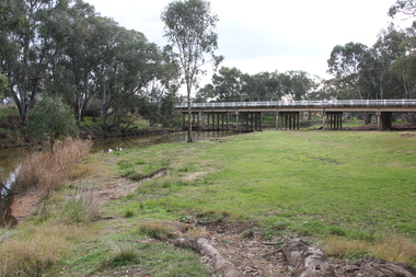
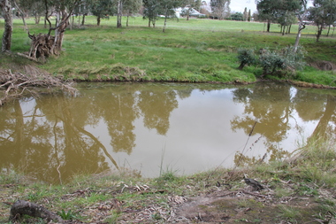
Photograph - Colour, L.J. Gervasoni, River at Avoca, 2011, 06/08/2011
Colour photograph of the swimming hole in the River at Avoca. avoca, pre-olympic swimming pool, avoca river -
 Ballarat Heritage Services
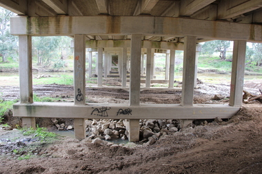
Photograph - Colour, L.J. Gervasoni, Bridge Over the River, Avoca, 2011, 06/08/2011
Colour photograph of the Bridge Over the River at Avoca.avoca, bridge, avoca river