Showing 2047 items
matching building and construction
-
 Kew Historical Society Inc
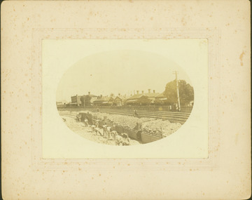
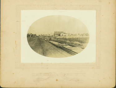
Photograph - Regrading the Camberwell Railway Line near Burke Road, E.J. Dower, 1915
One of a series of photographs, taken by Edgar James Dower in the second decade of the twentieth century. Born and raised in Olinda, his family later moved to Surrey Hills. He worked as an adult as a clerk in the city office of the Metropolitan Gas Company, and in his role as a 'collector', he was able to photograph scenes including the construction of tramlines, railways and associated buildings in Kew, Hawthorn, Camberwell and Surrey Hills. Later he established a real estate agency with his brother - the E.J. Dower Real Estate Agency, Dandenong Office.The image is an historically significant record of the development of transport infrastructure which was used to connect Victorians in the first two decades of the twentieth century. This development resulted from increases in population and the consequent extension of Melbourne's suburbs. The photographs, both individually and collectively, richly detail the labour of workers and the tools and machinery used to create and extend Melbourne's public transport network in the years preceding and during World War 1.Digital copy of an original oval mounted photograph depicting workers regrading the Camberwell Railway line in the vicinity of Burke Road following the demolition of the original Camberwell Railway Station. Verso: "1915 / Regrading Camberwell railway line, near Burke Road / Taken by E.J.Dower."theme -- connecting victorians by transport and communications, theme - camberwell railway station, theme - travelling by train -
 Kew Historical Society Inc
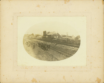
Photograph - Regrading the Camberwell Railway Line near Burke Road, E.J. Dower, 1915
One of a series of photographs, taken by Edgar James Dower in the second decade of the twentieth century. Born and raised in Olinda, his family later moved to Surrey Hills. He worked as an adult as a clerk in the city office of the Metropolitan Gas Company, and in his role as a 'collector', he was able to photograph scenes including the construction of tramlines, railways and associated buildings in Kew, Hawthorn, Camberwell and Surrey Hills. Later he established a real estate agency with his brother - the E.J. Dower Real Estate Agency, Dandenong Office.The image is an historically significant record of the development of transport infrastructure which was used to connect Victorians in the first two decades of the twentieth century. This development resulted from increases in population and the consequent extension of Melbourne's suburbs. The photographs, both individually and collectively, richly detail the labour of workers and the tools and machinery used to create and extend Melbourne's public transport network in the years preceding and during World War 1.Digital copy of an original oval mounted photograph depicting workers regrading the Camberwell Railway line following the demolition of the original Camberwell Railway Station. The level crossing gates at Burke Road can be seen in the distance. Named buildings include The Assembly Hall at right.Verso: "1915 / Regrading Camberwell railway line, near Burke Road / Taken by E.J.Dower."theme -- connecting victorians by transport and communications, theme - camberwell railway station, theme - travelling by train -
 Wodonga & District Historical Society Inc
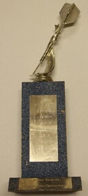
Award - Darts Trophy - A.W.D.D.A Winter '93 - A-Grade
The Terminus Hotel was one of the earliest hotels in Wodonga, with clear links to the establishment of the railway line. It was an important business and meeting place from the original construction in 1873 until 1st June 1998 the Terminus Hotel when it was destroyed by fire. It provided a popular venue for social activities, including competitive darts, both through its own competition and as part of the Albury-Wodonga District Darts Association. The remains of the building were demolished in 1999. This is a trophy for the Albury-Wodonga District Darts Association won by the team "Terminus Goers' in 1993.The Terminus Hotel was an important meeting place in Wodonga for more than 100 years. This item is representative of one of the social and sporting activities it provided for members of the local community.A trophy made from timber and metal with a representation of a dart on the top.On plaque lower front "A.W.D.D.A WINTER '93/A GRADE PREMIERS TERMINUS GOERS" In vertical list "B. TINGWELL (C) S. GRIFFITHS J. DE KRUIFF A. GARDNER R. GARDNER L. SIMS W. KILPATRICK B. SNEDDONterminus hotel, terminus hotel darts, sport and recreation wodonga -
 Wodonga & District Historical Society Inc
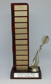
Award - Darts Trophy - Terminus Dart Club Doubles Championship, 1985
The Terminus Hotel was one of the earliest hotels in Wodonga, with clear links to the establishment of the railway line. It was an important business and meeting place from the original construction in 1873 until 1st June 1998 the Terminus Hotel when it was destroyed by fire. It provided a popular venue for social activities, including competitive darts, both through its own competition and as part of the Albury-Wodonga District Darts Association. The remains of the building were demolished in 1999. This is a perpetual trophy for the Terminus Dart Club Doubles Championship from 1985 to 1992.The Terminus Hotel was an important meeting place in Wodonga for more than 100 years. This item is representative of one of the social and sporting activities it provided for members of the local community.A wood and metal engraved trophy with stylised dart mounted on the side.At base: " TERMINUS DART CLUB/ DOUBLES CHAMPIONSHIP" On vertical list - top to bottom 1985 J. DEKRUIFF/ H. DEKRUIFF 1985 R. HUDSON/ A. FLEMING 1986 K. COOK/ H.M. COOK 1986 TONY LOWE / K.A.COOK 1987 J. DEKRUIFF/ A. FLEMING 1987 L. STOKES / K. MERRILESS 1988 J. DEKRUIFF/ T. LOWE 1989 ROB BENNETT/ B. STEWART 1989 L. BRUCE/B. STEWART 1991 J. DEKRUIFF/ P. HOLLINGSWORTH 1992 B. TINGWELL/ S. GRIFFITHS 1992 B. TINGWELL / C. BLUNDEN terminus hotel darts, terminus hotel wodonga, sport and recreation -
 Melbourne Legacy
Document, Residences
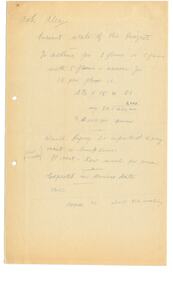
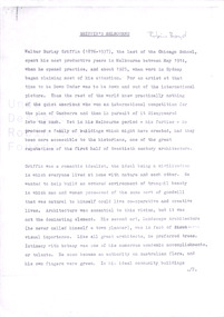
Handwritten anonymous notes, possibly 1971, headed "Ask Alec" and identifying information the writer needed such as 'Present state of the project'. There is no indication of what the project was beyond dates for the acceptance of tenders, start of construction and date of completion etc. Appears to be part of the review of the residences done at that time. When ideas for renovating and upgrading one of the homes was being considered. Apparently building would start in March 1972 and be completed before the end of 1972. There is no record of a Legatee called 'Alec' at the appropriate time in Melbourne Legacy records.Part of the history of Melbourne Legacy's involvement with residential care for children.2 pencilled foolscap sheets, black on discoloured white. Two holes punched for filing. residences, review -
 Melbourne Tram Museum
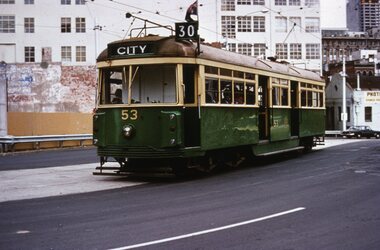
Slide, Tramway Museum Society of Victoria (TMSV), Tram VR 53 La Trobe St, c1974
Colour slide of VR class tram 53, route 30, westbound in La Trobe St on the bypass built to enable the construction of the Melbourne Central or Museum station between Dec 1973 and 1978 - see reference. The concrete looks relatively new in the photograph. The tram was originally built by the Victorian Railways for their St Kilda Brighton tramway in 1942. It is currently on display at the Melbourne Tram Museum. Many of the buildings in the background have since been demolished. The former Myer warehouse can be seen in the top right-hand corner of the photo.Yields information about VR tram 53 and Latrobe St c1974.Kodachrome colour slides, cardboard mount.Has "MP146" in pencil and stamped "Tramways Museum Society Victoria" on rear.tramways, vr class, tram 53, route 30, latrobe st -
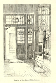
 Federation University Historical Collection
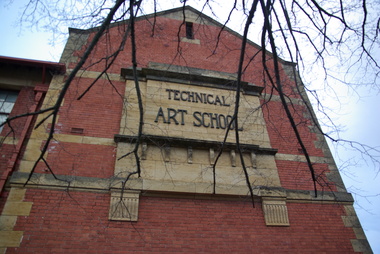
Photograph, Clare Gervasoni, Ballarat School of Mines Technical Art School, c2008, 29/07/2020
The former Ballarat Circuit Court Building, later the first building of the Ballarat School of Mines, was demolished to make way for a new custom built Art School building. Sir Alexander Peacock opened the Ballarat Technical Art School in July 1915. It cost 10,000 pounds and was constructed by the Public Works Department from plans drawn by the then Art School Principal, Herbert H. Smith. The building contractors were Messrs Gower and Eddards. According to the SMB Annual Report of 1914 'the internal upholstering and fittings have all been carried out in Australian timbers, with Queensland maple largely used throughout.' Before this building was constructed art and craft classes were held in various buildings around Ballarat. The building could be described as federation-art deco in style. It features sandstone insertion with sandstone string coursing. The base of the building is rusticated sandstone. The relief stone panel on the front with the words "Technical Art School" features stone pilaster brackets and corbels. In the centre front can be seen rectangular sandstone pediment with decorative stonework incorporating the date of construction. The windows in the lower floor feature five supporting keystones whereas the upper windows have sandstone lintels. The building also features decorative cast iron downpipes. The entrance on the northern side has attractive leadlight glazing in an art deco style. Above the door a miner's lamp and pick are featured in the design. The building is functional in design with large metal windows in the south wall to ensure good light into the studios. The northern wall has standard double hung windows. The interior of the building features a carved wooden staircase and cast iron ceiling vents. The rear drawing studios can be made into one large studio by opening panelled timber doors. This opening features classical plaster pilasters with a pediment above.Colour photograph of a sandstone detail on a double storey, red brick building - the Ballarat Technical Art School, a division of the Ballarat School of Minesballarat school of mines, ballarat technical art school, architecture, art, gribble building -
 Federation University Historical Collection
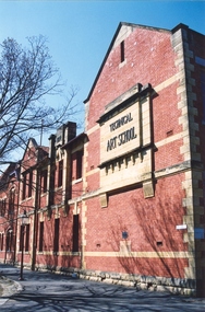
Photograph, Clare Gervasoni, Ballarat School of Mines Technical Art School, c2008, c2008
The former Ballarat Circuit Court Building, later the first building of the Ballarat School of Mines, was demolished to make way for a new custom built Art School building. Sir Alexander Peacock opened the Ballarat Technical Art School in July 1915. It cost 10,000 pounds and was constructed by the Public Works Department from plans drawn by the then Art School Principal, Herbert H. Smith. The building contractors were Messrs Gower and Eddards. According to the SMB Annual Report of 1914 'the internal upholstering and fittings have all been carried out in Australian timbers, with Queensland maple largely used throughout.' Before this building was constructed art and craft classes were held in various buildings around Ballarat. The building could be described as federation-art deco in style. It features sandstone insertion with sandstone string coursing. The base of the building is rusticated sandstone. The relief stone panel on the front with the words "Technical Art School" features stone pilaster brackets and corbels. In the centre front can be seen rectangular sandstone pediment with decorative stonework incorporating the date of construction. The windows in the lower floor feature five supporting keystones whereas the upper windows have sandstone lintels. The building also features decorative cast iron downpipes. The entrance on the northern side has attractive leadlight glazing in an art deco style. Above the door a miner's lamp and pick are featured in the design. The building is functional in design with large metal windows in the south wall to ensure good light into the studios. The northern wall has standard double hung windows. The interior of the building features a carved wooden staircase and cast iron ceiling vents. The rear drawing studios can be made into one large studio by opening panelled timber doors. This opening features classical plaster pilasters with a pediment above.Colour photographs of a double storey, red brick building built - the Ballarat Technical Art School, a division of the Ballarat School of Minesballarat school of mines, ballarat technical art school, architecture, art, gribble building -
 Kew Historical Society Inc
Plan, Melbourne and Metropolitan Board of Works, Borough of Kew : Detail Plan No.1580, 1904
The Melbourne and Metropolitan Board of Works (MMBW) plans were produced from the 1890s to the 1950s. They were crucial to the design and development of Melbourne's sewerage and drainage system. The plans, at a scale of 40 feet to 1 inch (1:480), provide a detailed historical record of Melbourne streetscapes and environmental features. Each plan covers one or two street blocks (roughly six streets), showing details of buildings, including garden layouts and ownership boundaries, and features such as laneways, drains, bridges, parks, municipal boundaries and other prominent landmarks as they existed at the time each plan was produced. (Source: State Library of Victoria)This plan forms part of a large group of MMBW plans and maps that was donated to the Society by the Mr Poulter, City Engineer of the City of Kew in 1989. Within this collection, thirty-five hand-coloured plans, backed with linen, are of statewide significance as they include annotations that provide details of construction materials used in buildings in the first decade of the 20th century as well as additional information about land ownership and usage. The copies in the Public Record Office Victoria and the State Library of Victoria are monochrome versions which do not denote building materials so that the maps in this collection are invaluable and unique tools for researchers and heritage consultants. A number of the plans are not held in the collection of the State Library of Victoria so they have the additional attribute of rarity.Original survey plan, issued by the MMBW to a contractor with responsibility for constructing sewers in the area identified on the plan within the Borough of Kew. The plan was at some stage hand-coloured, possibly by the contractor, but more likely by officers working in the Engineering Department of the Borough and later Town, then City of Kew. The hand-coloured sections of buildings on the plan were used to denote masonry or brick constructions (pink), weatherboard constructions (yellow), and public buildings (grey). The area represented in this detail plan has undergone significant change during the 20th century. The widening of High Street in the 1930s and 1950s involved the shops on the south side of High Street being demolished and later rebuilt to fit the widened street. Another significant loss was the mansion ‘Drayton’ fronting Wellington Street, owned at this stage by Susannah Fenton. Her family name would later to be given to Fenton Way, which was to be built over the grounds of the house following its demolition. The plan of the garden is particularly interesting, containing a batten dome fronting Wellington Street, an ornamental pond, a fountain and a brick and glass conservatory. The notes by the plumbing contractor on this plan are particularly detailed. Pink borders delineate the ownership of the varying parcels of land. Some of the better known owners listed include the real estate agent Cr. Henry de Castres Kellett (bt) and John Padbury, the funeral director. This particular plan provides a clear view of the configuration of the Kew Junction in 1903 and the commercial buildings that surrounded it.melbourne and metropolitan board of works, detail plans, maps - borough of kew, mmbw 1580, cartography -
 Kew Historical Society Inc
Plan, Melbourne & Metropolitan Board of Works : Borough of Kew : Detail Plan No.1585, 1904
The Melbourne and Metropolitan Board of Works (MMBW) plans were produced from the 1890s to the 1950s. They were crucial to the design and development of Melbourne's sewerage and drainage system. The plans, at a scale of 40 feet to 1 inch (1:480), provide a detailed historical record of Melbourne streetscapes and environmental features. Each plan covers one or two street blocks (roughly six streets), showing details of buildings, including garden layouts and ownership boundaries, and features such as laneways, drains, bridges, parks, municipal boundaries and other prominent landmarks as they existed at the time each plan was produced. (Source: State Library of Victoria)This plan forms part of a large group of MMBW plans and maps that was donated to the Society by the Mr Poulter, City Engineer of the City of Kew in 1989. Within this collection, thirty-five hand-coloured plans, backed with linen, are of statewide significance as they include annotations that provide details of construction materials used in buildings in the first decade of the 20th century as well as additional information about land ownership and usage. The copies in the Public Record Office Victoria and the State Library of Victoria are monochrome versions which do not denote building materials so that the maps in this collection are invaluable and unique tools for researchers and heritage consultants. A number of the plans are not held in the collection of the State Library of Victoria so they have the additional attribute of rarity.Original survey plan, issued by the MMBW to a contractor with responsibility for constructing sewers in the area identified on the plan within the Borough of Kew. The plan was at some stage hand-coloured, possibly by the contractor, but more likely by officers working in the Engineering Department of the Borough and later Town, then City of Kew. The hand-coloured sections of buildings on the plan were used to denote masonry or brick constructions (pink), weatherboard constructions (yellow), and public buildings (grey). This plan, which covers parts of High Street, Pakington Street and Derby Street is dominated by two historic Kew mansions: ‘Konetta’ and ‘Ramornie’. Ramornie was constructed in 1890 for James Maitland Campbell, three times Mayor of Kew. Sold in 1940, it became a boarding house known as ‘The Towers’. Now a private residence again, it has only one of its three balconies remaining. The location of the missing two balconies can be seen on the plan. In 1903, the grounds of Ramornie included a large tennis court fronting Pakington Street. The rear of the property is shown as extending to Cobden Street. One of Kew’s oldest hotels, the Prospect Hill Hotel on the corner of High and Cobden Street was established in 1858. The outline of the hotel shown on the plan represents the second building on the site. During the 19th century it was often used for electoral meetings. The Prospect Hill Hotel was to be redeveloped again in 1928, by the local architect Robert McIntyre. Since the 1980s, the hotel has been a live music venue, the home of the Melbourne Jazz Club, a restaurant and a liquor outlet.melbourne and metropolitan board of works, detail plans, maps - borough of kew, mmbw 1585, cartography -
 Kew Historical Society Inc
Plan, Melbourne & Metropolitan Board of Works : Borough of Kew : Detail Plan No.1563, 1905
The Melbourne and Metropolitan Board of Works (MMBW) plans were produced from the 1890s to the 1950s. They were crucial to the design and development of Melbourne's sewerage and drainage system. The plans, at a scale of 40 feet to 1 inch (1:480), provide a detailed historical record of Melbourne streetscapes and environmental features. Each plan covers one or two street blocks (roughly six streets), showing details of buildings, including garden layouts and ownership boundaries, and features such as laneways, drains, bridges, parks, municipal boundaries and other prominent landmarks as they existed at the time each plan was produced. (Source: State Library of Victoria)This plan forms part of a large group of MMBW plans and maps that was donated to the Society by the Mr Poulter, City Engineer of the City of Kew in 1989. Within this collection, thirty-five hand-coloured plans, backed with linen, are of statewide significance as they include annotations that provide details of construction materials used in buildings in the first decade of the 20th century as well as additional information about land ownership and usage. The copies in the Public Record Office Victoria and the State Library of Victoria are monochrome versions which do not denote building materials so that the maps in this collection are invaluable and unique tools for researchers and heritage consultants. A number of the plans are not held in the collection of the State Library of Victoria so they have the additional attribute of rarity.Original survey plan, issued by the MMBW to a contractor with responsibility for constructing sewers in the area identified on the plan within the Borough of Kew. The plan was at some stage hand-coloured, possibly by the contractor, but more likely by officers working in the Engineering Department of the Borough and later Town, then City of Kew. The hand-coloured sections of buildings on the plan were used to denote masonry or brick constructions (pink), weatherboard constructions (yellow), and public buildings (grey). This plan covers the area between Barkers Road, Wrixon Street, Sackville Street and Brougham Place, much of it now occupied by Carey Baptist Grammar and Preshil schools. This was an area of large and prestigious homes in 1903, some with formally laid-out gardens, such as ‘Tower Hill’ and ‘Opawa’. ‘Kalimna’ was built in 1890-91 for William H. Jarman, an accountant, and ‘Blackhall’ at the same time for W.H. Roberts. Blackhall was to be acquired by the Salvation Army in 1915 and renamed ‘Catherine Booth Girls’ Home’. The Home accommodated girls, aged between 4 and 16. Kalimna and Blackhall are of significance as typical and intact late Victorian mansions and as such are two key Victorian buildings to have been built in Kew. Both Blackhall and Kalimna are now part of Preshil. ‘Fairview’ was for a long time occupied by the Sisters of St. Joseph of Cluny as a care home for the elderly, but it is now part of Carey Grammar School, as are the grounds of ‘Wagga Merne’, ‘Weemutta’, ‘Blakely’, ‘Daheim’ and ‘Mildura’ (later ‘Urangeline’), the last being particularly impressive in 1903, with a tennis court, conservatory, outhouses, and two bathrooms!melbourne and metropolitan board of works, detail plans, mmbw 1563, cartography -
 Kew Historical Society Inc
Plan, Melbourne & Metropolitan Board of Works : Borough of Kew : Detail Plan No.1574, 1905
The Melbourne and Metropolitan Board of Works (MMBW) plans were produced from the 1890s to the 1950s. They were crucial to the design and development of Melbourne's sewerage and drainage system. The plans, at a scale of 40 feet to 1 inch (1:480), provide a detailed historical record of Melbourne streetscapes and environmental features. Each plan covers one or two street blocks (roughly six streets), showing details of buildings, including garden layouts and ownership boundaries, and features such as laneways, drains, bridges, parks, municipal boundaries and other prominent landmarks as they existed at the time each plan was produced. (Source: State Library of Victoria)This plan forms part of a large group of MMBW plans and maps that was donated to the Society by the Mr Poulter, City Engineer of the City of Kew in 1989. Within this collection, thirty-five hand-coloured plans, backed with linen, are of statewide significance as they include annotations that provide details of construction materials used in buildings in the first decade of the 20th century as well as additional information about land ownership and usage. The copies in the Public Record Office Victoria and the State Library of Victoria are monochrome versions which do not denote building materials so that the maps in this collection are invaluable and unique tools for researchers and heritage consultants. A number of the plans are not held in the collection of the State Library of Victoria so they have the additional attribute of rarity.Original survey plan, issued by the MMBW to a contractor with responsibility for constructing sewers in the area identified on the plan within the Borough of Kew. The plan was at some stage hand-coloured, possibly by the contractor, but more likely by officers working in the Engineering Department of the Borough and later Town, then City of Kew. The hand-coloured sections of buildings on the plan were used to denote masonry or brick constructions (pink), weatherboard constructions (yellow), and public buildings (grey). This plan shows several very large houses, particularly along Glenferrie Road, and the area now occupied by Ruyton Girls’ School. ‘Tarring’ (incorrectly spelled here as ‘Karring’) was built for Henry Henty in 1872, on part of his original allotment of 20 acres, and ‘Mount View’, which retains its original building and the fountain in the front garden, is part of Ruyton’s Junior School. The most significant change to Tarring and its grounds since 1903, involve the removal of a number of the outbuildings, including a Burmese temple, bought by Henty from the Burmese Exhibit at the Great Exhibition of 1880. It is shown on the plan as a summerhouse. The two-storey mansion, on the corner of Glenferrie Road and Wellington Street, was built in 1891 by leading architect Alfred White as his own home. Having an initial N.A.V. of £160, the house was purchased by a warehouseman Henry Lister, by 1900, when the N.A.V. was recorded at £111. By the turn of the century the house was known as ‘Comaques’. By contrast, much smaller houses are shown in Scott and Byron Streets, including a tiny Mission Hall in Byron Street, which belonged to the Anglican Church from at least 1903 to 1917.melbourne and metropolitan board of works, detail plans, maps - borough of kew, mmbw 1574, cartography -
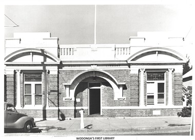 Wodonga & District Historical Society Inc
Photograph - Original Wodonga Library
W. Thorne architect of Albury designed the library building and the plan was approved in June 1915 The building contractor was J. W. Cochrane of Albury. The land was purchased from Mr. Walter Huon. On the 28th July 1915 the Shire President, Councillor Beardmore, laid the foundation stone for the building that would become the Wodonga Public Library. Almost 12 months later, on the 8th March 1916, the library was officially opened. It was the pride of Wodonga. The Shire Council closed their doors for a brief period so that all staff could attend the opening and the teachers and children of the local schools also attended. Councillor Beardmore declared that “it was an asset that would return a profit- not in pounds and shillings and pence but in the development and furnishing of the minds and lives of our young people”. It was known as the Beardmore Library. The Wodonga Athenaeum, in an out of the way location, had closed in 1914 after continuing reports of a lack of funds and the proceeds of the sale of the building went towards the building of the new library. In 1915 the library building committee started to put together a building fund for a new library. The library, situated at 78 High Street, was funded almost exclusively by the public. The books from the Athenaeum were presented to the library committee at the opening in 1916. The new library was both a place for education and recreation, a communal space to socialise, which also boasted a billiards room downstairs. In March 1970 construction of a new Civic Centre which included a library began in Wodonga. WIth its completion the following year, the original library was closed down. The building was vacant for some time and deteriorated badly. It was later purchased by Peter Middleton, who extensively restored the building. It is now the home of Middleton's Carpets.These images have local significance as they document an important building in Wodonga.2 photos - one black and white and one in colour of the same brick building. The first photo is of the building when it served as the Wodonga Public Library. The colour photo was taken approximately 60 years later.Photo 1 - In Brickwork above the door: PUBLIC LIBRARY Photo 2 - Above door: MIDDLETONS CARPETSwodonga public library, wodonga buildings -
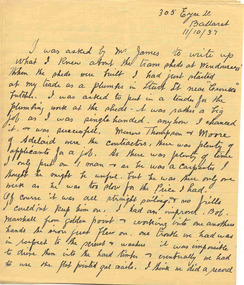 Ballarat Tramway Museum
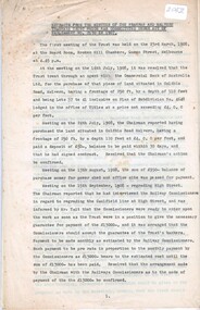
Document - Letter and Envelope, 1937
Five page handwritten letter on light brown or fawn lined paper within a brown envelope within Reg. Item 2488, page 105. The envelope has been glued to the back cover of the book and is address to "Mr. James Inspector / Electric Supply". Seven overseas stamps have been stuck to the envelope. The letter dated 11/10/1937 from an unknown person who lived at 305 Eyre St Ballarat, not signed, outlines the building the horse tram depot in Wendouree Parade. The person put in a quote as the plumber. Notes various aspects of working on the site, materials, difficulties, Thompson and Moore of the Adelaide as the contractors, number of people on the job, problems with the construction, wind damage, building the workers cottages, their rooves and the cash boxes for the conductors. Image 2520i2 shows the position on the page or back cover of items 2520 and 2521.Inktrams, tramways, horse trams, depot construction, depot, thompson and moore -
 Federation University Historical Collection
Artwork, other - Artwork, Artwork from the Ballarat School of Mines Students' Magazine, 1934, 1934
Sir Alexander Peacock opened the Ballarat Technical Art School in July 1915. It cost 10,000 pounds and was constructed by the Public Works Department from plans drawn by the then Art School Principal, Herbert H. Smith. The building contractors were Messrs Gower and Eddards. According to the SMB Annual Report of 1914 'the internal upholstering and fittings have all been carried out in Australian timbers, with Queensland maple largely used throughout.' Before this building was constructed art and craft classes were held in various buildings around Ballarat. The building could be described as federation-art deco in style. It features sandstone insertion with sandstone string coursing. The base of the building is rusticated sandstone. The relief stone panel on the front with the words "Technical Art School" features stone pilaster brackets and corbels. In the centre front can be seen rectangular sandstone pediment with decorative stonework incorporating the date of construction. The windows in the lower floor feature five supporting keystones whereas the upper windows have sandstone lintels. The building also features decorative cast iron downpipes. The entrance on the northern side has attractive leadlight glazing in an art deco style. Above the door a miner's lamp and pick are featured in the design. The building is functional in design with large metal windows in the south wall to ensure good light into the studios. The northern wall has standard double hung windows. The interior of the building features a carved wooden staircase and cast iron ceiling vents. The rear drawing studios can be made into one large studio by opening panelled timber doors. This opening features classical plaster pilasters with a pediment above. This building is now the Gribble Building on the Federation University Australia SMB Campus.Artwork by students of the Ballarat Technical Art School from the 1934 Ballarat School of Mines Students' Magazine .1) Stairs to the Ballarat Junior Technical School from Grant Street .2) Caricatures by Nornie Gude .3) work by Colin S. Hunt .4) A girl and a rooster by Gilda Gude .5) Self Portrait .6) Main entrance to the Ballarat Technical Art School by Lorna Bailey .7) Artwork from the magazineballarat technical art school, gribble building, gribble, stained glass, white flat, hopwood, bailey, gude, ballarat junior technical school, visual arts -
 Ringwood and District Historical Society
Booklet, City of Ringwood Report to Ratepayers 1977-1978, 1977
Yellow covered community information booklet for Ringwood residents covering Council Representatives' and Service Organisations' contact details, Major Works, Planning (Ringwood Business Centre), Recreation, Litter, Rubbish Tip, Construction of Private Streets (Greenway/Dickasons Road Group), Health and Community Services, Municipal Elections, Rates, Dog Registrations, Overhanging Foliage, Building By-laws, Vandalism, House Numbering, Fire Hazards, Council Finances, and other points of general interest. and local services, sporting, and cultural facilities. Includes two City of Ringwood Free Tipping Vouchers valid until the end of 1978.Mayor's Message - Cr. Lawrie Lawrenson.rinx -
 Bendigo Historical Society Inc.
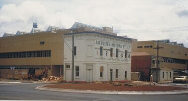
Photograph - A.W.PULFER MOTORS PTY LTD: CORNER OF MUNDY AND HARGREAVES STREET, BENDIGO
Black and white photograph, rendered brick 2 storey building, parapet, single storey section at back with tall square brick chimney. Includes bus shelter, electricity pole with transformer. 2 small trees plnated in nature strip. Rocks around trees. ' The Technical and Further education 'Ted Thompson'building under construction C 1982. In the centre is the former Royal Princess Hotel (now shown as A. W. Pulfer Motors), on the corner of Mundy and Hargreaves Streets which was demolished in February 1983. Specimen Cottage is to the right. ' On back '11' Ward/A/FSP/1204' 'O'organization, education, tafe college -
 Ballarat Tramway Museum
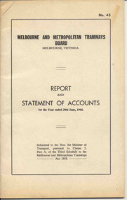
Document - Report, Melbourne and Metropolitan Tramways Board (MMTB), "Report and Statement of Accounts" for year ended 30 June 1964, 1964
Annual report of the MMTB for the year end 30/6/1964 - No. 45 - buff heavy paper cover with 48 pages on inside giving details of the MMTB Board, Officers, Balance Sheet, Statement of funds, operation, schedule of debenture, investments, Auditors reports, record of Annual traffic receipts, passengers, miles etc, tram and bus routes operated, statistical information, graphs and photographs. Photos include trams operating in Stuttgart, Dusseldorf, Frankfurt-on-Main, window display Victoria House London, overseas recruiting, test equipment in a W class tram, building construction, Doncaster.trams, tramways, mmtb, melbourne, annual reports, operations, trackwork -
 Wodonga & District Historical Society Inc
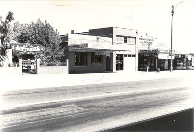
Photograph - Codling Collection 01 - High Street just south of South Street. Early to mid 1980's
Miss Olive Codling was a Foundation Member and a Life Member of the Wodonga Historical Society. Many of her prize-winning photos are held in the Society Collection. She also held a range of roles and committee positions in a wide range of Wodonga community organisations. These included the Horticultural Society, the Wodonga Arts Council, the Wodonga Camera Club and the Wodonga Lapidary Club. This photo collection is significant as it documents how the businesses and buildings in Wodonga have evolved and contributed to community throughout the 20th century.Buildings in High Street just south of the intersection with South Street, Wodonga. Businesses including Chitty's Antiques, Hoover City Chinese Restaurant, Phegan Real Estate and Jay Dean Construction. Between Hoover City and Phegan's was Number 90 High Street. Harris Lieberman Solicitors was at that location in the mid 1970s. In 2021, a hairdresser operates out of the former Phegan's store and Hoover City is the location of Rock 'n' Roll Roasts. Chitty's Antiques occupied part of the former Bank of N.S.W. premises. It later became The Secret Cup coffee shop which has since closed.wodonga businesses, high st wodonga, chitty antiques, phegan real estate, hoover city chinese restaurant -
 Melbourne Tram Museum
Document - Research Notes, H. S. McComb, "Extracts from the Minutes of the Prahran and Malvern Tramways Trust which was constituted under Act of Parliament No. 21030 in 1907", 1940's
Original and carbon copy of "Extracts from the Minutes of the Prahran and Malvern Tramways Trust which was constituted under Act of Parliament No. 21030 in 1907", 10 foolscap sheets. Includes depot purchase, regrading of High St, extension to Burke Road, relocation of water mains, surveys, starting of construction, tenders for track and buildings, opening, extension, F. A. McCarty & Co., Dandenong Road lines, railway bridges, extension of High St to St Kilda Road, MMBW, finances. Items 2041 to 2052 within box 72.3 in a brown folder marked "PMTT" in red pencil.trams, tramways, pmtt, malvern, routes, track, surveys, malvern rd, tenders, construction, opening, dandenong rd, mmbw, finances -
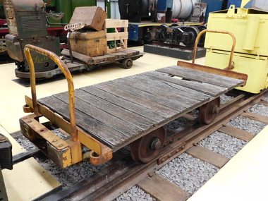 Puffing Billy Railway
Explosives Wagon, unkown
This 2 foot 6 inch (762mm) gauge wagon was used for carrying explosives and was used with the Greenbat Battery loco. It was donated to the Walhalla Goldfields Railway on long term loan in 2013 along with a large quantity of narrow gauge trollies and light rail from Orica’s now closed munitions factory in Melbourne’s western suburbs. Orica - Deer Park Munitions factory Orica Deer Park in Melbourne’s west has been used since circa 1875 for various forms of manufacturing and storage of chemicals. Although the site is bounded by Ballarat Road, Station Street, Tilburn Road and the Western Ring Road, the current entry point for industrial operations is situated at Gate 6 of Tilburn Road. Operations include: • a specialty chemicals facility producing products for mining services operations • quarry services • other chemical manufacture activities. The Deer Park factory complex The factory complex is of historical significance for the major role it played in Australia's manufacturing and mining industries through the development of progressively more efficient and safer explosives. It also contributed to wartime production in ammunition, initiators and the development of synthetic ammonia production and construction of the Defence Explosives Annexe No 5 (later the Albion Explosives Factory) during World War Two. The factory complex is also of technical significance for the unusual and specialised design of many of the buildings and structures, both in the layout of the works and the individual design of buildings. Blast protection and safety measures such as mounds around the buildings, 'cleanways' and buffer zones between production areas were employed extensively. A characteristic of many production buildings was the elimination of cavities where explosive compounds could lodge. The combination of concrete barriers and light-weight construction was designed to direct explosion debris away from operators or other buildings. The narrow gauge tramway, which ran through the explosives section, is a rare survivor of nineteenth century materials-handling methods. Historic - Industrial Narrow Gauge Railway - Wagon for carrying Explosives at the Orica - Deer Park Munitions factory, Deer park, Victoria, Australia Wagon for carrying explosives made from Timber and steelwagon for carrying explosives, puffing billy, industrial narrow gauge railway, orica - deer park munitions factory, explosives wagon -
 Kew Historical Society Inc
Plan, Melbourne & Metropolitan Board of Works : Borough of Kew : Detail Plan No.1296, 1904
The Melbourne and Metropolitan Board of Works (MMBW) plans were produced from the 1890s to the 1950s. They were crucial to the design and development of Melbourne's sewerage and drainage system. The plans, at a scale of 40 feet to 1 inch (1:480), provide a detailed historical record of Melbourne streetscapes and environmental features. Each plan covers one or two street blocks (roughly six streets), showing details of buildings, including garden layouts and ownership boundaries, and features such as laneways, drains, bridges, parks, municipal boundaries and other prominent landmarks as they existed at the time each plan was produced. (Source: State Library of Victoria)This plan forms part of a large group of MMBW plans and maps that was donated to the Society by the Mr Poulter, City Engineer of the City of Kew in 1989. Within this collection, thirty-five hand-coloured plans, backed with linen, are of statewide significance as they include annotations that provide details of construction materials used in buildings in the first decade of the 20th century as well as additional information about land ownership and usage. The copies in the Public Record Office Victoria and the State Library of Victoria are monochrome versions which do not denote building materials so that the maps in this collection are invaluable and unique tools for researchers and heritage consultants. A number of the plans are not held in the collection of the State Library of Victoria so they have the additional attribute of rarity.Original survey plan, issued by the MMBW to a contractor with responsibility for constructing sewers in the area identified on the plan within the Borough of Kew. The plan was at some stage hand-coloured, possibly by the contractor, but more likely by officers working in the Engineering Department of the Borough and later Town, then City of Kew. The hand-coloured sections of buildings on the plan were used to denote masonry or brick constructions (pink), weatherboard constructions (yellow), and public buildings (grey). This area was once known as O’Shaughnessy’s Paddock. O’Shaughnessy was the licensee of the Kew Hotel. The ‘Paddock’ or farm was for many years the closest farm to Melbourne. By 1903, when this plan was surveyed and lithographed, little of the farm remained. The area is dominated by a ‘clay hole’, on the site of the current Foley Reserve. It was used by Smart’s Brickyard from the 1880s until 1911, when the Council purchased it for a rubbish dump. It is notable as the site is one of the few industrial operations to have existed in Kew. By 1903, urban development was characterised by larger houses fronting Barkers Road and brick and weatherboard villas in Foley Street. Nearer the pit, weatherboard houses predominated. Foley Street bisected the triangular block and continued right to Denmark Street. At this stage, a house impeded the through road, only allowing access via a right of way to High Street.melbourne and metropolitan board of works, detail plans, mmbw 1296, cartography -
 Kew Historical Society Inc
Plan, Melbourne & Metropolitan Board of Works : Borough of Kew : Detail Plan No.1301, 1910
The Melbourne and Metropolitan Board of Works (MMBW) plans were produced from the 1890s to the 1950s. They were crucial to the design and development of Melbourne's sewerage and drainage system. The plans, at a scale of 40 feet to 1 inch (1:480), provide a detailed historical record of Melbourne streetscapes and environmental features. Each plan covers one or two street blocks (roughly six streets), showing details of buildings, including garden layouts and ownership boundaries, and features such as laneways, drains, bridges, parks, municipal boundaries and other prominent landmarks as they existed at the time each plan was produced. (Source: State Library of Victoria)This plan forms part of a large group of MMBW plans and maps that was donated to the Society by the Mr Poulter, City Engineer of the City of Kew in 1989. Within this collection, thirty-five hand-coloured plans, backed with linen, are of statewide significance as they include annotations that provide details of construction materials used in buildings in the first decade of the 20th century as well as additional information about land ownership and usage. The copies in the Public Record Office Victoria and the State Library of Victoria are monochrome versions which do not denote building materials so that the maps in this collection are invaluable and unique tools for researchers and heritage consultants. A number of the plans are not held in the collection of the State Library of Victoria so they have the additional attribute of rarity.Original survey plan, issued by the MMBW to a contractor with responsibility for constructing sewers in the area identified on the plan within the Borough of Kew. The plan was at some stage hand-coloured, possibly by the contractor, but more likely by officers working in the Engineering Department of the Borough and later Town, then City of Kew. The hand-coloured sections of buildings on the plan were used to denote masonry or brick constructions (pink), weatherboard constructions (yellow), and public buildings (grey). Throughout its history, the land in what is known today as Studley Ward of the City of Boroondara has been subject to continuing subdivision. This is evident in Plan 1301, where later hands have modified the original map to include streets created subsequent to the printing of the plan in 1904. Other annotations such as the ‘Reserved for Road Purposes’ beside the Yarra never eventuated. The plan continued to be modified to at least 1953, when a later hand noted that a particular site was ‘Property site P. McIntyre house’ in Swinton Avenue. Two significant houses in the area are outlined on the plan: ‘Swinton’ on the corner of the streets then named Effey and Maud Streets (now Swinton Avenue) and ‘Fairhaven’ [unnamed] in Stevenson Street. The gardens of the two David Syme owned mansions of ‘Blythswood’ and ‘Rockingham’, stretching down to the River Yarra, are also represented.melbourne and metropolitan board of works, detail plans, mmbw 1301, cartography -
 Glen Eira Historical Society
Document - Grange Road, Corner of Neerim Road, Glen Huntly
This file contains 3 items about the construction of this property: 1/An original typed building agreement dated 25/09/1936 between the contractor Ernest F Barnard and the purchaser Mr & Mrs Hulbert Gorrie 2/The original blue print plan of a brick villa at the corner of Grange & Neerim Road for Mr & Mrs Hulbert Gorrie. Dated 25/09/1936 3/The original specification for the dwelling on the corner of Grange & Neerim Road, Glen Huntly for Mrs Gertrude Gorrie & Mr Hulbert Hopetoun Gorrie by builder Ernest F Barnardbarnard ernest f, gorrie gertrude, gorrie hulbert hopetoun, hobart john bertram, coorigil road, carnegie, holloway st, ormond, chemists, parish of prahran, caulfield county of bourke, building agreement, brick houses, builders, plans, architectural drawings, grange road, glen huntly, holloway street, ormond, emma street, grange road, neerim road, barnard ernest f, gorrie h.h, gorrie gertrude, gorrie hulbert h, legal documents -
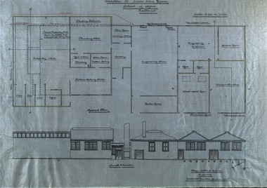 Federation University Historical Collection
Plan - Plans, Ballarat School of Mines Plans for the Additions to Trades Class Rooms
Born in Ballarat, George William Clegg F.R.V.I.A. was articled to Tappin, Gilbert and Dennehy who had architectural offices in Melbourne, Sydney and Ballarat, from 1885-1889. Clegg formed a partnership with Gilbert who ran the Ballarat Office and later with Kell and Miller. This eventually became Clegg and Miller, then Clegg Miller and Morrow, and finally Clegg and Morrow (1916). From about 1907 up until his resignation in 1918 Clegg taught Architecture and Building Construction at the Ballarat School of Mines. From 1918 he pursues interests in the Eureka Terracotta and Tile Company.Two plans on linen, relating to additions in the trade classrooms at the Ballarat School of Mines.ballarat school of mines, george clegg, george william clegg, george w. clegg, clegg, miller and morrow, trades, architecture, buildings -
 Robin Boyd Foundation
Document, Robin Boyd, Griffin's Melbourne, 1964
Boyd discusses the influence and legacy of the work of Walter Burley Griffin on Melbourne's architecture. Boyd discusses the utopian tendencies of Griffin as well as his temperament and approach to practice. The text goes on to discuss Griffin's exemplary works including the Capitol Building and Leonard House and the ongoing legacy of Griffin's work. Griffin's patented construction system, 'Knitlock', is also discussed with exemplary projects using this system mentioned. Griffin's influence is concluded as initially controversial and jarring to the conservative nature of Melbourne suburbia, but later becomes exemplary work and essential to the progression of Melbourne's architecture.Typewritten, photocopy, 15 pages, A4, 210x297.Signature. Pencil mark up on page 2, 3, 4, 6, 7, 9, 14.walter burley griffin, chicago school, melbourne, sydney, canberra, a.s. eggleston, edward billson, marion griffin, knitlock, capitol theatre, leonard house. -
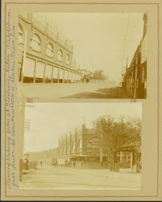 Kew Historical Society Inc
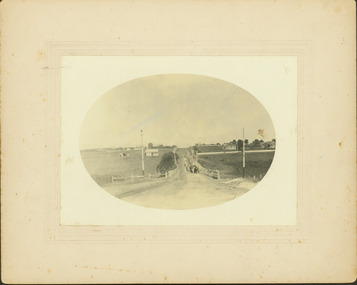
Photograph - Railway level crossing in Glenferrie Road, Glenferrie, E.J. Dower, 1912
Contextual or historic information One of a series of photographs, taken by Edgar James Dower in the second decade of the twentieth century. Born and raised in Olinda, his family later moved to Surrey Hills. He worked as an adult as a clerk in the city office of the Metropolitan Gas Company, and in his role as a 'collector', he was able to photograph scenes including the construction of tramlines and associated buildings in Kew, Hawthorn, Camberwell and Surrey Hills. Later he established a real estate agency with his brother - the E.J. Dower Real Estate Agency, Dandenong Office.The image is an historically significant record of the development of transport infrastructure which was used to connect Victorians in the first two decades of the twentieth century. This development resulted from increases in population and the consequent extension of Melbourne's suburbs. The photographs, both individually and collectively, richly detail the labour of workers and the tools and machinery used to create and extend Melbourne's tram network in the years preceding and during World War 1.Two faded original horizontal photographs, mounted on vertical card showing the original railway level crossing in Glenferrie Road, Hawthorn, before a railway overpass was constructed and the laying of the electric tramline. The two photos depict northern and southern views of the crossing. Dimensions: Photo 1 106 x 157 mm Photo 2 107 x 147 mm Mount 249 x 197 mmAnnotated recto: "Showing tramway gates at Glenferrie, taken 1912 by E.J. Dower, just prior to construction of electric tramline." Verso: "1912"theme --- travelling by tram, theme -- connecting victorians by transport and communications, trams -- boroondara (vic.), tramways -- hawthorn, trains -- hawthorn (vic.), glenferrie station -
![Electric tramway construction in Riversdale Road [Surrey Hills]](/media/collectors/550653872162f11fb04854aa/items/661deb37344c8682d4fa54e0/item-media/661dec13344c8682d4fa98bd/item-fit-380x285.jpg) Kew Historical Society Inc
Kew Historical Society IncPhotograph - Electric tramway construction in Riversdale Road [Surrey Hills], E.J. Dower, 1916
Contextual or historic information One of a series of photographs, taken by Edgar James Dower in the second decade of the twentieth century. Born and raised in Olinda, his family later moved to Surrey Hills. He worked as an adult as a clerk in the city office of the Metropolitan Gas Company, and in his role as a 'collector', he was able to photograph scenes including the construction of tramlines and associated buildings in Kew, Hawthorn, Camberwell and Surrey Hills. Later he established a real estate agency with his brother - the E.J. Dower Real Estate Agency, Dandenong Office.The image is an historically significant record of the development of transport infrastructure which was used to connect Victorians in the first two decades of the twentieth century. This development resulted from increases in population and the consequent extension of Melbourne's suburbs. The photographs, both individually and collectively, richly detail the labour of workers and the tools and machinery used to create and extend Melbourne's tram network in the years preceding and during World War 1.Digital copy of an original mounted photograph of construction of the electric tramline in Riversdale Road, Surrey Hills.Annotated verso: "Showing the commencement of preparing for electric trams in Riversdale Road / Taken from the corner of Union Road, note Essex road on right with picket fencing"theme --- travelling by tram, theme -- connecting victorians by transport and communications, trams -- boroondara (vic.), tramlines -- surrey hills -
 Kew Historical Society Inc
Photograph - Construction of the electric tram line in Riversdale Road, Surrey Hills, E.J. Dower, 1916
Contextual or historic information One of a series of photographs, taken by Edgar James Dower in the second decade of the twentieth century. Born and raised in Olinda, his family later moved to Surrey Hills. He worked as an adult as a clerk in the city office of the Metropolitan Gas Company, and in his role as a 'collector', he was able to photograph scenes including the construction of tramlines and associated buildings in Kew, Hawthorn, Camberwell and Surrey Hills. Later he established a real estate agency with his brother - the E.J. Dower Real Estate Agency, Dandenong Office.The image is an historically significant record of the development of transport infrastructure which was used to connect Victorians in the first two decades of the twentieth century. This development resulted from increases in population and the consequent extension of Melbourne's suburbs. The photographs, both individually and collectively, richly detail the labour of workers and the tools and machinery used to create and extend Melbourne's tram network in the years preceding and during World War 1.Digital copy of an original oval mounted photograph depicting preparation for laying the tracks for the new electric tramline in Riversdale Road, Surrey Hills. Annotated verso: "Riversdale Road Surry Hills / preparing for electric tram line / Taken just west of Middlesex Road, looking west"theme --- travelling by tram, theme -- connecting victorians by transport and communications, trams -- boroondara (vic.), riversdale road -- surrey hills -
 Kew Historical Society Inc
Photograph - Riversdale Road, Surrey Hills, E.J. Dower, c.1915
Contextual or historic information One of a series of photographs, taken by Edgar James Dower in the second decade of the twentieth century. Born and raised in Olinda, his family later moved to Surrey Hills. He worked as an adult as a clerk in the city office of the Metropolitan Gas Company, and in his role as a 'collector', he was able to photograph scenes including the construction of tramlines and associated buildings in Kew, Hawthorn, Camberwell and Surrey Hills. Later he established a real estate agency with his brother - the E.J. Dower Real Estate Agency, Dandenong Office.The image is an historically significant record of the development of transport infrastructure which was used to connect Victorians in the first two decades of the twentieth century. This development resulted from increases in population and the consequent extension of Melbourne's suburbs. The photographs, both individually and collectively, richly detail the labour of workers and the tools and machinery used to create and extend Melbourne's tram network in the years preceding and during World War 1.Digital copy of an original oval mounted photograph depicting Riversdale Road, Surrey Hills, before the construction of the proposed electric tramline.Annotated verso: "Riversdale Road Surrey Hills / Preparing for electric tram line / Note Essex Road on right with picket fencing."theme --- travelling by tram, theme -- connecting victorians by transport and communications, riversdale road -- surrey hills, tramlines -- surrey hills