Showing 5276 items matching "dwelling"
-
 The Beechworth Burke Museum
Photograph
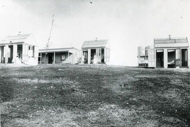
These images are copies of a photograph (3448) captured in approximately 1900 and depicts the on site nurses homes. During the 1880s, these detached cottages were constructed and provided accommodation for the staff (in this case, the nurses) who lived within the hospital walls. Within the image are weatherboard buildings, a number of nurses and water tanks. Beechworth's Mayday Hills was chosen as the site of Victoria's newest asylum, at the time, due to the landscape and altitude. The hilltop atmosphere and the native fauna, it was argued, would assist in the cure of the patients kept at the hospital (Wood 1985, 122). The positioning of the hospital had a beneficial effect on the rural town. A pamphlet published by James Ingram and Son (1849) reveal that famous landmarks in Beechworth which included the Post Office, Gaol, Courthouse and Asylum "demonstrate the appreciation of Beechworth by the Government not only as as important district center, but also as a site unrivaled as a sanitarium". There were other locations in contention at the time, but ultimately Beechworth was chosen (Craig 2000, 33). Prior to the creation of the Asylum in Beechworth, those charged with having mental illnesses or, as it was termed, "insanity" were unable to be properly cared for in the Gaol (which is where they were often sent). John Buckley Castieau wrote, in 1861 for the Ovens and Murray Advertiser, that the Gaol was unable to properly care for those classified then as "insane" but that they would endeavor to treat them above the other inmates (which he notes is not always the case in other establishments). Castieau wrote this in favour of supporting the building of the Mayday Hills Hospital in Beechworth. It was stated that at the time the Mayday Hills Hospital was built, there were 83 prisoners kept in the Gaol who were to be rehoused to the Hospital on the grounds of "insanity". The classification as someone as "insane", in this period of time is a reflection on the inability to cure and understand illnesses of the mind during the mid to late 1800s. Opening on the 24th of October 1867, the Mayday Hills Hospital was originally named the "Ovens Lunatic Asylum", a title which is very much a product of its time. Whilst controversial, changes to the name is part of the history of the Hospital and can provide much insight into the understanding of mental illness throughout history and the use/disuse of this term provides information into the reception/changing opinions of mental illness in society. The Hospital would later become known as the "Mayday Hills Asylum" and/or "Mayday Hills Hospital" with the latter being the most commonly used title. An article in the Ovens and Murray Advertiser notes that on the 7th of March 1865, the foundation stone of the Hospital was laid (it would officially open in 1867) and that it was such a moment of accomplishment and joy for Beechworth that a letter to the editor even suggested that there should be a holiday dedicated to the day the foundation stone as laid. This reveals an extent to which the townspeople of early Beechworth valued the construction of the Hospital in their town. It provided the town with a sense of prestige and honour.At first glance, the remains of the Mayday Hills Hospital in Beechworth, Victoria, inspire tragedy, trauma and beauty. The buildings themselves, with their Italianate style Renaissance architecture designed by J.J. Clark (Craig 2000, 49 & Smith 2016, 203) reflect a bygone period of European and Australian history. The gardens provide a sense of tranquility and beauty. The experience of those within these walls remains a valuable area of study to provide a more complete understanding. This particular hospital is considered the fourth of its like and one of three identified as the largest of their kind. The Mayday Hills Hospital is a sister to the Kew and Ararat Asylums in Melbourne which are both located in relative proximity. Understanding the role of the Mayday Hills Hospital in Beechworth history is integral to understanding the development of the goldfields town, but also for providing important information as to the history of caring for, and the reception of, mental illnesses in Australian and wider European history. Mayday Hills provides a case study which can be researched through oral history, an analysis of the grounds/buildings and through images like these. Images like these depict the strong façade of the Hospital and provide a glimpse into the tranquility of the gardens. This has been done deliberately to provide a sense of comfort and healing about the building to those looking from the outside. Further research into the importance of the Hospital in Beechworth and it's connection to the town will be supported through images like these kept in the Mayday Hills photo album in the collection of the Burke Museum.Black and white rectangular photograph printed on gloss photographic papermental hospital, mayday hills, beechworth, copy, nurse, nurses quarters, on-site dwelling, 1900s, 1880, beechworth asylum -
 Port of Echuca
Colour photograph, Approx 1979
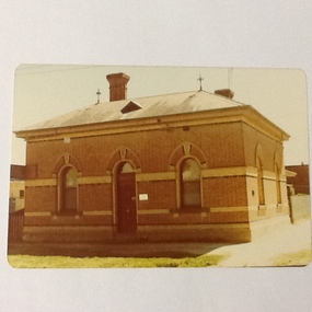
Customs building: built 1884 to handle goods entering Victoria up to 1901. Building classified B by National Trust.Customs houses, of similar design, were built along the Murray river to collect taxes on goods transported from N. S. W. to Victoria. The taxes were collected up until Federation in 1901. The Victorian railways used it as an office until about the 1960 when it became a private dwelling. The Customs House at Echuca is now owned by The Port of Echuca and has been used to house a wine tasting businesses, cafe and local produce retail and art gallery.Colour photograph of Customs House at Echuca port.In ink on reverse: "8A"customs house, echuca, echuca historical buildings, echuca, port of (customs history) -
 Port of Echuca
Colour photograph, 1977
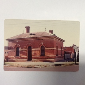
Customs building: built 1884 to handle goods entering Victoria up to 1901. Building classified B by National Trust.Customs houses, of similar design, were built along the Murray river to collect taxes on goods transported from N. S. W. to Victoria. The taxes were collected up until Federation in 1901. The Victorian railways used it as an office until about the 1960 when it became a private dwelling. The Customs House at Echuca is now owned by The Port of Echuca and has been used to house a wine tasting businesses, cafe and local produce retail and art gallery.Colour photograph of Customs House at Echuca port.In ink on reverse: Dec.77-M: Print made by Kodak: Kodak. In pencil Customs Housecustoms house, echuca, echuca historical buildings, echuca, port of (customs history) -
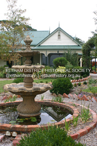
 Eltham District Historical Society Inc
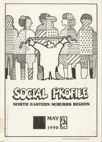
Book, Community Services Victoria, Social Profile: North Eastern Suburbs Region, May 1990
Local Government summaries for Diamond Valley, Eltham, Heidelberg, Northcote, Preston, Whittlesea. Provides census data and comparisons between years with summaries on topics including: Population, Age Distribution, Marital Status, Single Parents, Family Annual Income, Personal Annual Income, Social Security Income, Psychiatric Hospitla Admissions and departures, Aboriginal and Torres Strait Islanders, Persons born Overseas and country of origin, Langauges, English competence of overseas born persons, Occupancy of dwellings, Structure of occupied dwellings, type of occupanncy, private rents, monthly mortgages, households with no vehicle, level of qualifications, occupational status, employment, industry groups, unemployment, school attendance.119 pagesnon-fictionLocal Government summaries for Diamond Valley, Eltham, Heidelberg, Northcote, Preston, Whittlesea. Provides census data and comparisons between years with summaries on topics including: Population, Age Distribution, Marital Status, Single Parents, Family Annual Income, Personal Annual Income, Social Security Income, Psychiatric Hospitla Admissions and departures, Aboriginal and Torres Strait Islanders, Persons born Overseas and country of origin, Langauges, English competence of overseas born persons, Occupancy of dwellings, Structure of occupied dwellings, type of occupanncy, private rents, monthly mortgages, households with no vehicle, level of qualifications, occupational status, employment, industry groups, unemployment, school attendance.statistics, population, demographics, social profile, census data -
 Eltham District Historical Society Inc
Photograph - Digital Photograph, Alan King, Pigeon Bank, one of the Nillumbik shire's oldest farm dwellings, 6 February 2008
In 1848, Francis Rogerson form Dumfriesshire, Scotland purchased 80 acres of land at Kangaroo Ground on which he built a two-roomed bark hut. He named the property afterr the many Bronzewings and Wonga Pigeons in the area. Ewen Hugh Cameron moved to Pigeon Bank the same year he was elected to Parliament as the Member for Evelyn. At the time he moved in, Pigeon Bank had six rooms and the present water well. He made further extensive additions and lived there until his death in 1915. Covered under Heritage Overlay, Nillumbik Planning Scheme. Published: Nillumbik Now and Then / Marguerite Marshall 2008; photographs Alan King with Marguerite Marshall.; p27This collection of almost 130 photos about places and people within the Shire of Nillumbik, an urban and rural municipality in Melbourne's north, contributes to an understanding of the history of the Shire. Published in 2008 immediately prior to the Black Saturday bushfires of February 7, 2009, it documents sites that were impacted, and in some cases destroyed by the fires. It includes photographs taken especially for the publication, creating a unique time capsule representing the Shire in the early 21st century. It remains the most recent comprehenesive publication devoted to the Shire's history connecting local residents to the past. nillumbik now and then (marshall-king) collection, ewen hugh cameron, francis rogerson, kangaroo ground, kangaroo ground-warrandyte road, pigeon bank -
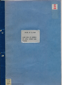 Eltham District Historical Society Inc
Document - Folder, Shire of Eltham, Land uses by number of lots, street and riding, 1984
In work undertaken by the Shire of Eltham in revising its residential multi-unit development policy, information was collated by street and number of units. The exercise was expanded to include other land uses. At the end of each Riding is given a summary of the number of the various major land uses and index to abbreviations used on the last page11 pages inside blue coverharry gilham collection, land use, streets, ridings, dwellings, units -
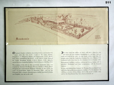 Bendigo Military Museum
Souvenir - SOUVENIR OF GAZA, C 1940-42
The card relates to a collection re John EDWARDS VX3857 2nd AIF. Refer Cat No 536 for his service details.Pamphlet red ink. drawing of Gaza house (folded) back has description and history. mounted on cardboard. History reproduced and posted under souvenir pamphlet.illustrations - pen ink, middle east, dwellings, gaza, souvenirs -
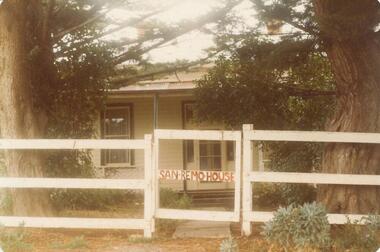 Phillip Island and District Historical Society Inc.
Photograph, 1880's
San Remo house built by Charles Grayden 1880? Possibly Miss Elms' home.Coloured photograph of front of house behind two Cypress Pines - post and rail fence across foreground.San Remo house in red on gatelocal history, photography, photographs, slides, film, san remo, local area development by europeans, housing, coloured photograph, commercial development san remo, dwellings -
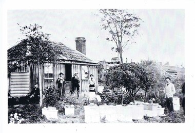 Greensborough Historical Society
Photograph, Home of Mr Coghill Greensborough, 1910c
Shows the home of Mr Coghill which was the former Mitchell house located between the railway line and the Plenty River and directly opposite the end of Jessop Street.This shows the type of dwelling the early settlers lived in, also what they had in their cottage gardens.A rectangular black and white photograph of 4 men and 1 woman in a garden outside a shingle hut with bee hives near them.shingle hut, cottage garden, bee hives, coghill, mitchell, 1910 -
 Orbost & District Historical Society
Postcard - post card, early 20th century
This postcard was produced as a black and white card titled, "Early 1900 - Bush Hut , Gippsland", in the early 20th century. The original card had a blank white rectangular strip on the right side of the photograph. This was for the message. There is little information with this item except for a note indicating that it was a hut at Newmerella. This is a pictorial record of a bark hut of the kind built by the early settlers of East Gippsland. Few early settlers could afford the time, or possessed the capital, to build any dwelling more impressive than a slab hut: Postcards form a vital part of social and historical records for researchers. A postcard showing a bearded man sitting on a stool outside a bark hut. There are various tools - a wheelbarrow and shovels, buckets, a panning dish and a saw hanging above him to the left. . It is in a bush setting and the photograph has been tinted.on back - POSTCARD - in red :"Essie & Ruby McKena. Emily Ville, Ascot Vale Road Flemington"dwelling-bush hut-bark -
 Orbost & District Historical Society
framed photograph, 14.4.2004
This photograph was taken on 14.4.2004 at the time of the visit to Orbost by the Governor of Victoria, John Landy.The Orbost Visitor Information Centre is situated in Forest Park on Nicholson Street. The centre is housed in the historic Slab Hut. The hut was an original family dwelling built in 1872, on a site approximately three kilometres upstream from the junction of the Buchan and Snowy Rivers. The Slab Hut is an Orbost Icon. It supports one part time manager and a team of dedicated volunteers.A coloured photograph in a wooden frame. A group of people stand in front of the Slab Hut (Orbost Information Centre) .On frame - NATURAL FEATURED HARDWOOD MADE BY 20.12.98 W. ASHLYN MARLO VIC.slab-hut-committee photograph -
 Federation University Historical Collection
Book, New Zealand Geographical Society, Proceedings of the International Geographical Union Regional Conference and Eighth New Zealand Geography Conference, 1974, 1975
Robert H.T. Smith was Chancellor of University of Ballarat (later Federation University Australia).Soft covered book.robert h.t. smith, geography, papua new guinea, tourism in hawaii, quuensland reserve dwelling aborigines, pollution of lake burely griffin -
 Stawell Historical Society Inc
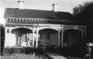
Photograph, Wooden Home at no.1 Seaby Street -- Coloured photo
Home in Seaby Street no.1 next to railway line. Built by Luke Kinsella about c 1870. Photo taken March 1992 about time of sale. A series of nine coloured photos in Album 8. p 37-42 of the Seaby house and interior. Photos in album 8 show 3 different views of the side of the building. One of the wood paneling in the entrance hall. Also 3 photos of the mantlepieces and cast iron grates in the fireplace. Luke Kinsella, brother to Thomas Kinsella's (part owner of Magdala cum Moonlight mine). Thomas was the eldest of the boys then Luke and John Kinsella the youngest. Home in Seaby Street no.1 next to railway line. Built by Luke Kinsella about c 1870. Colour photograph. Series of 9 photos in Album 8. p37-42.stawell dwellings -
 Stawell Historical Society Inc
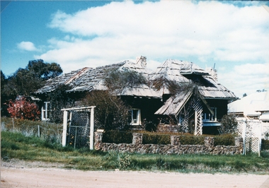
Photograph, Log Cabin c 1930's with Iron roof
Log Cabin built by Mr. J. Wharrie c 1930’s. Originally the Log cabin had a bark roof. The roof was replaced with iron. The home is located in Darlington Road Stawell. The Wharrie family lived in the cabin for many years during the 1940's and owned a doll factory. Black & white photograph depicting a home built of logs with a lattice porch way, stone chimney's and iron roof. On the iron roof is a weather vane decorated on top by a carriage and 2 horses. The house is set in a garden with a stone fence in the foreground. There are 2 black & white prints one an enlargement of the smaller photograph.stawell dwelling -
 Stawell Historical Society Inc
Photograph, Weatherboard House at 4 Skene St
Weatherboard home no. 4 Skene Street. The main feature is the lace work along the veranda. There is a half circle of iron work centrally placed on the veranda roof. Black & white photograph of a weather board home with and iron roof at no. 4 Skene St Stawell. The building has a brick fence and balustrade with elaborate iron lace work.stawell dwelling -
 Stawell Historical Society Inc
Photograph, St Joseph's Convent in Patrick St
Saint Joseph’s Convent Patrick Street once the family home of the Kinsella family. The house was built in 1900 by architect M. Ryan and building contractor A. J. Barnes for Thomas Kinsella who occupied the home till he died in 1902. The Kinsella family later sold the house to the Catholic Church and was occupied by the Sisters of St Joseph. 3 Black & White photographs of a brick home with slate roof. The veranda has iron posts and iron lacework. The second photo of the house show St Patrick's Catholic Church located next to the house. The third photo is an enlarged photo of the house & church view.stawell dwelling -
 Stawell Historical Society Inc
Photograph, Miners Small Brick Cottage -- early example in Curtis St
Small brick cottage a typical example of an early miners cottage located in Curtis Street. Mr. Hammer brickmaker, lived in the cottage. The cottage was also home to Mr. & Mrs. Vic Bullen for many years. Van Diesan later bought the cottage.Black & White photograph of a small brick college with corrugated iron roof. stawell dwelling -
 Stawell Historical Society Inc
Photograph, Wooden Home at 1 Seaby Street
Wooden Home no. 1 Seaby Street built for Luke Kinsella. Luke Kinsella was Thomas Kinsella's younger brother. He worked as a miner turned publican and investor. Black & white photograph of a wooden home, front wall vertical boards. The veranda hosts twin wooden columns, and the building has a corrugated iron roof. The veranda is missing part of its decorative edging on the left hand side. A series of 9 coloured photos of the house and interior in Album 8 p.37-45, Research room.stawell dwellings -
 Stawell Historical Society Inc
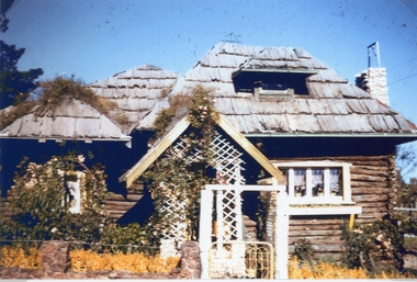
Photograph, Log Cabin c 1948 -- Coloured
Log Cabin built by J Wharrie during 1930's c1948. These photos show the original bark roof. There is also a lattice entrance on the front fence not shown on photo 40.Two photos one black & white the other coloured of the Log Cabin c 1948. The bark roof appears to have a vine growing over the front and side of the roof. The lattice work on the porch is damaged.stawell dwelling -
 Stawell Historical Society Inc
Photograph, Log Cabin c 1930's -- Coloured
Colour photo Log Cabin built by J Wharrie during 1930s. The photo was taken from a colour slide from Allan Howells Collection. Photo taken c 1960 -70.Log Cabin built by Mr. J. Wharrie during the 1930's. This photo is a front view of the house with vine growing over the porch and bark roof. A weather vane can be just made out on the roof. stawell dwelling -
 Stawell Historical Society Inc
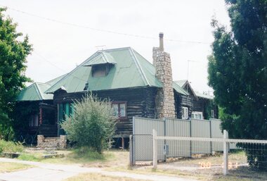
Photograph, Log Cabin c 2000 -- Coloured
Colour photo Log Cabin Darlington Road built by J Wharrie. This coloured print taken in c 2000.Colour Photograph of the Log cabin taken in 2000. The roof is iron and a green colour. The front entrance porch has been removed and a low fence at the front. The top of the chimney has also changed.stawell dwelling -
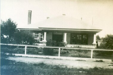
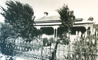 City of Ballarat Libraries
Photograph, Architectural features for 4 Errard Street South, Ballarat
4 Errard Street South was owned by Miss Jessie Gillett, who can be seen in photo 377. Features shown include timber panelling, Art Nouveau design leadlights in the door, ceiling rose and arches. The veranda has iron scalloped frieze.building, private dwelling, errard street south, jessie gillett, architecture -
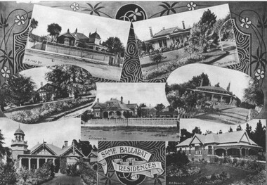 City of Ballarat Libraries
Photograph - Card Box Photographs, Some Ballarat residences, c1915
These houses were owned by J.H. Jones, Fred Williams, W.F. Coltman, P.S. Richards, George Buchanan and A.H. Briant. This appeared in the Ballarat Homecoming publication.houses, ballarat, ballarat homecoming, j.h. jones, fred williams, w.f. coltman, p.s. richards, george buchanan, a.h. briant, building, private dwelling -
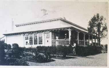 City of Ballarat Libraries
Photograph - Card Box Photographs, George Smith's residence, Ballarat c1870
The Wendouree Parade residence of George Smith, Nurseryman. The house included an iron balustrade, glass window paned conservatory and square pillars holding up the veranda.george smith, wendouree parade, building, public dwelling, garden, ballarat, house -
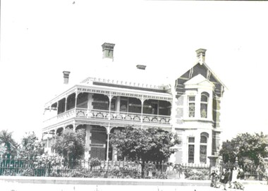 City of Ballarat Libraries
Photograph - Card Box Photographs, Former residence of Walter Davis, Ballarat c1950
This building in Victoria Street has ornamental brickwork, iron frieze balustrade, leadlight and chimney bay windows. It has been used as the Teachers College residence and thought to have been built by mining speculator, Forbes.victoria street, ballarat, private dwelling, building, walter davis, teachers college, forbes -
 City of Ballarat Libraries
Photograph - Card Box Photographs, 907 South Street, Ballarat c1934
At one time, 907 South Street won a garden competition. Unfortunately, a fire destroyed the building in 1938.south street, ballarat, building, private dwelling, garden -
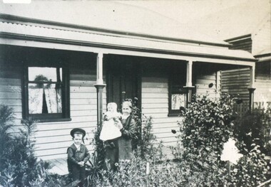 City of Ballarat Libraries
Photograph - Card Box Photographs, 412 Windermere Street, Ballarat 1904
This photo shows Mrs Parry and children, Marjery and David, who would later become a plumber.windermere street, ballarat, marjery parry, david parry, building, house, garden, private dwelling -
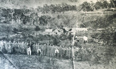 City of Ballarat Libraries
Photograph - Card Box Photographs, Pioneer Settlement Selection, Ballarat c1870
This selection was located in Grenville and owned by David Alfred Pattenden. His father, the man leaning on the fence, was a journalist.pioneer settlement selection, ballarat, grenville, private dwelling, house, david alfred pattenden -
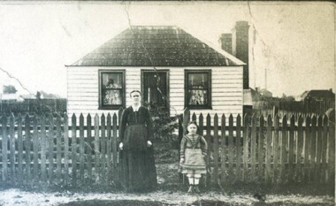 City of Ballarat Libraries
Photograph - Card Box Photographs, Elizabeth Whitla's Cottage, Ballarat c1877
Elizabeth Whitla and her daughter, who was 6 at the time, stand outside their cottage. This building may have been on Essex Street.elizabeth whitla, ballarat, cottage, building, private dwelling, costume, garden -
 City of Ballarat Libraries
Photograph - Card Box Photographs, 318 Creswick Road, Ballarat circa 1910
creswick road, ballarat, building, house, garden, snow, private dwelling