Showing 9551 items
matching east street
-
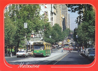
 Melbourne Tram Museum
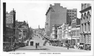
Postcard, Rose Stereograph Co, "Lonsdale Street Melbourne', c1933
... Melbourne', looking east from Queen Street. Has several cable trams...', looking east from Queen Street. Has several cable trams in the far ...Rose Series postcard No. P 3645, titled "Lonsdale Street Melbourne', looking east from Queen Street. Has several cable trams in the far distance at Swanston Street. In the view is the Myer Emporium Lonsdale Street store and the Eastern Hill fire station tower. There are adverts for Dulux, Tribune, Wynss, Fox films, A E Hoad? Stillwell Stephens. The cable trams in Lonsdale Street west of Elizabeth Street closed in early 1935 and the remainder in 1939. Yields information about Lonsdale St c1933.Postcard - printed real photograph with Rose Stereograph Co. name on the rear.Has the 3rd part of a letter to Ken on the rear.trams, tramways, cable trams, lonsdale st, myer -
 Mission to Seafarers Victoria
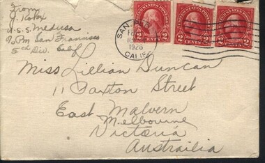
Letter - Correspondence, Julius Kokx, Letter to Lillie from Julius Kokx, January 31, 1926
... Letter addressed to Miss Lillian Duncan, 11 Paxton Street... to Miss Lillian Duncan, 11 Paxton Street, East Malvern, Melbourne ...The "letters to Lillie" show the international nature of the Mission to Seafarers. They are an important display of the handwriting style of the time, revealing courting attempts and give us an insight into life in 1925 and 1926.Lillie Duncan was a member of the Harbour Lights Guild and this letter forms part of a collection of letters sent to her by different seafarers.Letter addressed to Miss Lillian Duncan, 11 Paxton Street, East Malvern, Melbourne, Victoria, Australia from J. Kokx, U.S.S. Medusa, c/o PM San Francisco, 5th Div. Calif consisting of two parts. 0073.1 Envelope; 0073.2 Letter (double-sided). Both the envelope and the letter are cream in colour. The letter begins with "My Dearest Melbourne Girl: I recieved your...". The letter has a ships seal printed and embossed onto it in blue ink.The envelope has been torn across the top horizontally in order to retrieve the letter from inside. The flap on the back is still sealed. The envelope has three sets of stamps. The first is a circular black ink stamp with the text "SAN PEDRO Feb 1 [indecipherable] 1926 CALIF". The second stamp is a set of three red almost square stamps reading "UNITED STATES POSTAGE 2 CENTS". The last stamp is in black ink and has 7 curved lines resembling the waves of the sea which continues over to the back of the envelope where it stops curving. This set of lines stops and starts across half of the back of the envelope. Both of the black ink stamps overlay the three red stamps.letter, california, handwriting, mission-to-seafarers, lillie-duncan, uss-medusa, east-malvern, envelope, letters-to-lillie, san-pedro, julius-kokx, julius kokx, lhlg, lillie duncan, us navy, uss medusa -
 Bendigo Historical Society Inc.
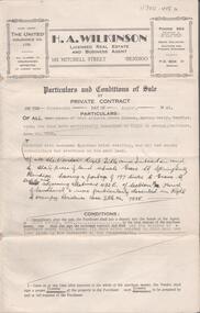
Document - H. A. & S. R. WILKINSON COLLECTION: CONTRACT OF SALE
... a frontage of 197 links to Grave Street east and adjoining allotment... links to Grave Street east and adjoining allotment 432E section ...Conditions of sale by private contract dated 14th August, 1945 between R. D. Bawden (vendor) and Mrs. M. Steel (purchaser). Property: land situate in Grave Street, Spring Gully, having a frontage of 197 links to Grave Street east and adjoining allotment 432E section H, Parish of Sandhurst, land described in right to occupy residence area title No. 7885, together with 4 room Egyptian brick dwelling and all sundry outbuildings. Price: 280 pounds.organization, business, h.a. & s.r wilkinson real estate -
 Ballarat Tramway Museum
Photograph - Black & White Photograph/s, David Endacott, 14/08/1971 12:00:00 AM
... side, looking to the east of Armstrong Street, Saturday 14... photograph and negative of Sturt St, north side, looking to the east ...Black and white photograph and negative of Sturt St, north side, looking to the east of Armstrong Street, Saturday 14 August 1971 at the corner of Armstrong St. Has two single truck trams at the intersection with Lydiard St. North and a few parked cars. Original print by David Endacott, duplicate print (1262A) by John Phillips 12/99. Second copy added 5/2001. Original neg scanned at hi res and updated 11/5/2020.On original print "From Cnr Sturt & Armstrong Sts / Sat 14 Aug 1971" in pencil.trams, tramways, ballarat, sturt st., armstrong st. -
 Ballarat Tramway Museum
Slide - 35mm slide/s, Keith Kings, 20/01/1963 12:00:00 AM
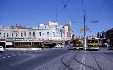
... , 3.36pm. Photo taken from View St. looking east along Mitchell... from View St. looking east along Mitchell Street. Tram 11 ...Bendigo, Charing Cross, four Birneys on Sunday 20-1-1963, 3.36pm. Photo taken from View St. looking east along Mitchell Street. Tram 11 to North, 30 to Golden Aq, 28 to Quarry Hill and 29 to Eaglehawk. Note road signs (yellow with black writing)on centre poles, Ezywalkin building in rear, cross over in foreground. Black and white version of photo appears on page 66 of K.S.Kings book 'The Bendigo Tramways'. Photo by Keith Kings.Stamped on 'K.S.Kings etc.' and in blue ink 'K(r)(390), Bendigo, 1/250., f8 20/1/63, Charing Cross, Sunday, 3.36pm 11 to North, 30 to Golden Square, 28 to Quarry Hill, 29 to Eaglehawk.'tramways, trams, bendigo, birney, charing cross, tram 11, tram 30, tram 28, tram 29 -
 Kew Historical Society Inc
Map, MMBW, MMBW Plan No.65 Kew & Heidelberg, 1900-1910
... of Kew, bordered on its north by Malmsbury Street, in the west... Road, and in the east by Princess Street. The map shows ...The Melbourne and Metropolitan Board of Works (MMBW) was established by an act of the Victorian Parliament in 1890 to prepare for and to implement a sewerage and water reticulation system across what was then inner Melbourne, its surrounding and middle distance suburbs, including Kew. The MMBW was disbanded in 1991.The map collection of the Kew Historical Society has at its core the historic maps assembled and originally stored in the City Engineer's Department of the City of Kew. These include maps in a number of scales. The vast majority of maps were produced by the MMBW in the first two decades of the twentieth century, and are solid working maps, backed by linen for durability. These maps are historically significant to Kew, the City of Boroondara and to the history of the development of state utilities in Victoria. A number of the Kew maps have additional details added by former municipal officers, including the levels reached by various floods. As these were working documents, information was added to them long after the period of their initial production and distribution.Early map of part of the Borough of Kew, created in the first decade of the twentieth century, at a scale 160 ft to 1 inch. The map covers what was then the south central part of Kew, bordered on its north by Malmsbury Street, in the west by Florence Avenue, in the south by Barkers Road, and in the east by Princess Street. The map shows the extent of urban development by that time, prominent institutions and the outlines of built structures in the municipality. Contour lines were added in ink to the map at a later stage.MELBOURNE AND METROPOLITAN BOARD OF WORKS / PLAN NO. 65 / KEW & HEIDELBERGmelbourne & metropolitan board of works, mmbw maps, mmbw plans, borough of kew, cartography -
 Ringwood and District Historical Society
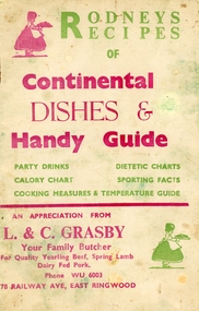
Booklet, Grasby, L. and C, Rodney's Recipes of Continental dishes and Handy Guide. From Your local Butcher (L & C Grasby, 78 Railway Avenue, East Ringwood, WU 6003) c1960, c1960
... the Ives family lived at 2 Lois Street, East Ringwood until moved... the Ives family lived at 2 Lois Street, East Ringwood until moved ...Given to customers of L. and C. Grasby, Your Family Butcher, 78, Railway Avenue, East Ringwood.Roney's Recipes of Continental Dishes and handy Guide of party drinks, calorie chart, dietetic charts, sporting facts, cooking measures and temperature guide.10 page booklet plus cream coloured covers with red and green printing on both sides. Contains recipes for various occasions, drinks, charts, cooking measures and temperature guide. Given to customers of the butcher. Covering letter from Mrs. Ives +Additional Keywords: Grasby / Ives, Mrs. Norma. All the Ives family lived at 2 Lois Street, East Ringwood until moved away, except for the eldest Ted and his daughter Lynda who lived at 4 Lois Street. -
 Ballarat Tramway Museum
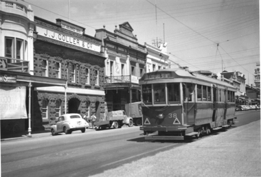
Photograph - Tram 38 Lydiard St Nth, mid 1950s
... buildings on the east side of the street. Photographer and date... buildings on the east side of the street. Photographer and date ...The photograph shows SEC Ballarat tram No. 38 outbound in Lydiard St North, Ballarat. The tram has large reflective triangles on the front that were added during 1956. In the background is the bluestone building of J J Coller & Co and other buildings on the east side of the street. Photographer and date unknown - mid-1950s.Yields information about tram 38 and Lydiard St North Ballarat.Black and White print on plain paper.tramcars, tram 38, lydiard st nth -
 St Kilda Historical Society
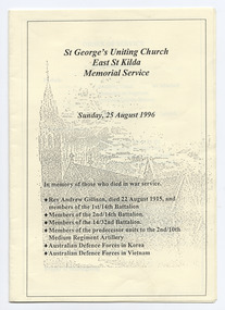
Ephemera - Program - religious service, St George's Uniting Church East St Kilda Memorial Service, 1996
... Chapel Street, East St Kilda, and then a concert back... Chapel Street, East St Kilda, and then a concert back ...Annual memorial service in memory of those who died in war service, including former minister Rev Andrew Gillison, MA, who served as Chaplain for overseas service in World War I and died at Gallipoli in 1915 while attempting to rescue a wounded soldier. Held on 25 August 1996.The memorial service was followed by a lunch, a tour of the Army Depot, 2nd/10th Medium Regiment Artillery, 8 Chapel Street, East St Kilda, and then a concert back at the church later in the afternoon.Pamphlet of three cream coloured pages, folded and printed on both sides in black. Unbound. Illustration of the church on the front. rev andrew gillison, 14th battalion aif, 2/14th army battalion -
 Eltham District Historical Society Inc
Photograph, Tillings timber yard, Bridge Street, Eltham, 1968, 1968
... Photographer is standing on Bridge Street looking east... melbourne Photographer is standing on Bridge Street looking east ...Photographer is standing on Bridge Street looking east on the main road to Greensborough from Eltham. Bridge Street under re-construction. Across the road from Tillings timber yard is Sharmac Industries which was a factory now occupied by Bunnings. It gave off a bad smell. This was the main light industrial area in the Shire of Eltham. Digital copy of colour photographfred mitchell collection, 1968, eltham, bridge street, n.j. tillings, tillings timber yard, light industrial area -
 Stawell Historical Society Inc
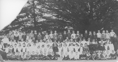
Photograph, Patrick St State School - Branch School Stawell East Primary School Number 1986 -- Students & Teacher photo c 1898
... Branch School - Stawell East Primary School. Patrick Street... grampians Branch School - Stawell East Primary School. Patrick ...Branch School - Stawell East Primary School. Patrick Street State School number 1986. Photo of school group and teachers. Mabel Sargent 6th from left, second bottom row. Mabel died 21.1.1899 giving approximate date of photograph. c 1896. Stawell East is now the Secondary College in Stawell.Sepia photograph of school group at Patrick St. State School Number 1986. Branch School - Stawell East Primary School and Teachers c 1898. The photo has 4 rows of students with pine trees in the background.Patrick St. State School No. 1986 Mabel Sargent 6th from left, second bottom row Died 21-1-1899stawell education -
 Wodonga & District Historical Society Inc
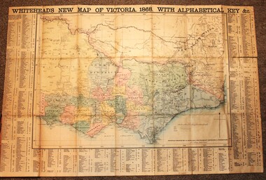
Map - Whiteheads New Map of Victoria, E. Whitehead & Co., engravers & lithographers, 1868
... founded his printing business at 67 Collins Street East in 1864... business at 67 Collins Street East in 1864 and, though not focused ...Edward Whitehead was a printer and publisher active in Melbourne during the latter half of the 19th century. Whitehead founded his printing business at 67 Collins Street East in 1864 and, though not focused on maps, began publishing his own series of maps of Victoria in 1867. He focussed on producing highly detailed folding maps of Victoria which included a very detailed index of place names. His series of maps of Victoria became one of the most successful and most profitable series of regional maps of Australia ever produced.This is a very early map of Victoria showing Belvoir (Wodonga)A detailed early map of Victoria with counties clearly marked and shaded and a detailed index. It also shows roads, post office towns, railways, telegraphs, gold mining areas and notes on topography. Relief shown by hachures and spot heights. Includes a list of towns with distances from Melbourne on 3 sides of map. It is produced on paper mounted on linen.victoria cartography, rare maps victoria, whiteheads maps -
 Kew Historical Society Inc
Map, MMBW, MMBW Plan No.39 Kew & Heidelberg, 1900-1910
... Boulevard] , by Princess Street in the East and Holroyd Street... [and the later added Yarra Boulevard] , by Princess Street in the East ...The Melbourne and Metropolitan Board of Works (MMBW) was established by an act of the Victorian Parliament in 1890 to prepare for and to implement a sewerage and water reticulation system across what was then inner Melbourne, its surrounding and middle distance suburbs, including Kew. The MMBW was disbanded in 1991.The map collection of the Kew Historical Society has at its core the historic maps assembled and originally stored in the City Engineer's Department of the City of Kew. These include maps in a number of scales. The vast majority of maps were produced by the MMBW in the first two decades of the twentieth century, and are solid working maps, backed by linen for durability. These maps are historically significant to Kew, the City of Boroondara and to the history of the development of state utilities in Victoria. A number of the Kew maps have additional details added by former municipal officers, including the levels reached by various floods. As these were working documents, information was added to them long after the period of their initial production and distribution.Early map of part of the Borough of Kew, created in the first decade of the twentieth century, at a scale 160 ft to 1 inch. The map covers what was then the north western section of Kew, bordered on its north by Wills Street and the Kew Lunatic Asylum, in the west by the River Yarra [and the later added Yarra Boulevard] , by Princess Street in the East and Holroyd Street in the south. The map shows the extent of urban development by that time, prominent institutions and the outlines of built structures in the municipality. Contour lines were added in ink to the map at a later stage.MELBOURNE AND METROPOLITAN BOARD OF WORKS / PLAN NO. 39 / KEW & HEIDELBERGmelbourne & metropolitan board of works, mmbw maps, mmbw plans, borough of kew, cartography -
 City of Ballarat Libraries
35mm Slide, Ballarat Orphanage
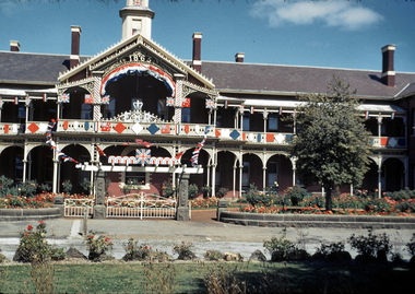
... Ballarat Orphanage, Victoria Street, Ballarat East, decked... Ballarat East goldfields Ballarat Orphanage, Victoria Street ...Ballarat Orphanage, Victoria Street, Ballarat East, decked in flags probably for the Queen's visit in 1954. Mrs Bon Strange and her husband Bert were well known Ballarat residents. When Mrs Strange died some years ago, her extensive slide collection was sorted through and those relevant to Ballarat were gifted to the Ballarat Library. -
 Ballarat Heritage Services
Photograph - Photograph - Colour, Ballarat Female Refuge - Alexandra Babies' Home, 2000
... to the Ballarat Orphanage in Stawell Street, Ballarat East. The Babies... to the Ballarat Female Refuge in Scott's Parade, Ballarat East. The babies ...The Alexandra Babies' Home was adjacent to the Ballarat Female Refuge in Scott's Parade, Ballarat East. The babies from the unmarried mothers at the Refuge remained at the Babies' Home until around the age of three years, when they were usually transferred to the Ballarat Orphanage in Stawell Street, Ballarat East. The Babies' Home was suddenly closed in 1973 under the Hamer Government. Postcard size coloured photographsballarat female refuge - alexandra babies' home, scott's parade, female refuge, ballarat babies' home, alexandra babies' home -
 Linton Mechanics Institute and Free Library Collection
Book - Novel, Fox, Norman A, Lord Six-Gun, [n.d.] [1943?]
... in another collection: "The Joycelyn Book Club, 462 Lygon Street... collection: "The Joycelyn Book Club, 462 Lygon Street, East Brunswick ...Western adventure story.158 p. red cover, title and author's name printed on spine. Section of original dust jacket pasted to front cover, with image of a horse and cowboy who is holding and firing hand guns. Summary of story also cut from dust jacket is pasted inside front cover.fictionWestern adventure story.fiction, westerns, norman a. fox -
 Ringwood and District Historical Society
Map - Plans of Subdivision, Part of Crown Allotments 35 & 39, Parish of Warrandyte
... Albert Street East Melbourne (Ref 118/2a b &c) Tel 41-6960... Albert Street East Melbourne (Ref 118/2a b &c) Tel 41-6960 ...Survey maps of stages 1, 2 & 3 of residential allotments in Kalinda Road and Grayling Crescent, Ringwood, Victoria. (Undated, circa 1960). Some allotments are marked with real estate information and prices in pre decimal £s.Adshead & McGuire, Land Surveyors L.S. M.I.S. (Aust), 268 Albert Street East Melbourne (Ref 118/2a b &c) Tel 41-6960. The land colored blue is set apart for drainage & sewerage purposes. Reference Marks (R.M's) are Gal Iron Pipes 12"x1". Levels shown are to M.M.B.W. Datum. The land shown hatched is subject to innundation. -
 Ballarat Heritage Services
Book - digital copy, Ballarat East High School School Magazine 1967, The Lion, 1967
... Ballarat East High School is situated in Fussell Street... in Fussell Street, Ballarat East. In the year 1967 the headmaster Mr ...Ballarat East High School is situated in Fussell Street, Ballarat East. In the year 1967 the headmaster Mr O'Connor retired after 13 years at the school. He was there from its inception in the early 1950s, when classes only ran to Form 3 (Year 9). He saw it grow into a viable High School, instigated the musical program and saw excellence in sports.27 double page spreads, plus cover pageBryan Dunkley-Smith on top right hand corner of first page behs, ballarat east high school, a. b. o'connor, mr o'connor -
 Stawell Historical Society Inc
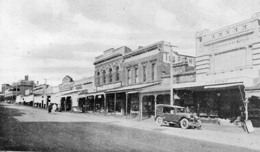
Postcard, Front Cover, Upper Main Street Stawell looking East & & looking West -- 3 Photos -- Postcards 1920's
... Front Cover, Upper Main Street Stawell looking East...Views of Stawell. INCLUDES view of Main Street looking... Main Street Stawell looking East & & looking West -- 3 Photos ...Views of Stawell. INCLUDES view of Main Street looking East showing from right Strangio & Pizione fruit shop. Sun Printing Works. Tea Rooms. King. Carters Boot Shop. Taylor. Bull and Mouth in distance. Car visible. ALSO Main Street Looking West showing from right Norman A Harding Taylor and Outfitter. Geo Mitchell & Sons stawell businesses streetscape -
 Ballarat Tramway Museum
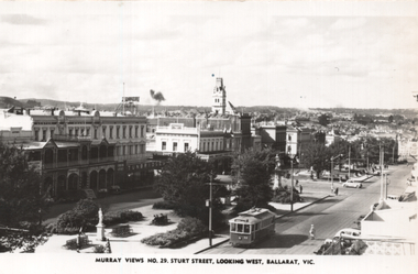
Postcard, Murray Views, "Murray Views No. 29 Sturt Street, looking west Ballarat Vic", 1948
... Photo shows the view looking east along Sturt Street from... east along Sturt Street from Harry's building, The card has ...Photo shows the view looking east along Sturt Street from Harry's building, The card has been wrongly titled as looking west. Tram 32 is westbound to the Gardens. In the view are Lester House, Crockers, and Tunbridge's stores. On the rear Wal Jack in a note to Ken Magor of Newcastle has drawn in a diagram of the track arrangements, where the tram was. His notes are "Sturt St looking EAST, 1948. No. 32 painted the new colour scheme. Photo taken from Doveton St corner." See item 5313 for a digital image of this postcard.Yields information about the view from the SW Corner of Sturt St looking north east.Postcard black and white, plain back, with a handwritten note on rear.See image 2 for details of the handwritten note by Wal Jack on the rear. tramways, trams, sturt st, tram 32 -
 Melbourne Tram Museum
Postcard - Collins Street - Biscay A1 239, Biscay Greetings, late 1980's
... to the east of Swanston Street. At the time of the photograph all... Postcard looking west along Collins Street. just to the east ...Postcard looking west along Collins Street. just to the east of Swanston Street. At the time of the photograph all trams have been converted to The Met colour scheme. Swanston Street was converted into Swanston walk during 1992, so photo is late 1980's or early 1990's. There are seven trams in the view: A1 239 (City Route 42), SW5 749 in Swanston Street, A1 232 (Mont Albert Route 42), two advertising cars. Collins Street is busy. Note the Hook Turn signs supported off the overhead wires.Yields information about Collins Street late 1980's or early 1990s prior to the construction of Swanston WalkPostcard - red boarders, Collins Street - Biscay Greetings, BG 275collins street, swanston street, a1 class tram, sw5 class trams, tram 239, tram 232, tram 749, trams, tramways -
 Ballarat Tramway Museum
Photograph - Digital image, Alwyn Marshall, 1960
... and the photograph shows the cutting wall on the east side of the street... the cutting wall on the east side of the street after the intersection ...Yields information about the appearance of No. 32, Lydiard St North and Macarthur St intersection in 1960.Digital image from the Wal Jack Ballarat Album of a photograph of No 32 southbound in Lydiard St at the intersection with Macarthur St. Has a Milk Bar - shop on the right hand side and the photograph shows the cutting wall on the east side of the street after the intersection. Photo by Alwyn Marshall. Possibly printed by Wal Jack as it has his handwriting on the rear. See image i2 for rear of photograph.On rear of photograph in ink "SEC, Ballarat No. 32 to Sebastopol in Lydiard St Nth at Macarthur St 1960 A. Marshal Photo."trams, tramways, lydiard st nth, macarthur st, tram 32 -
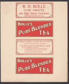 Bendigo Historical Society Inc.
Document - CAMBRIDGE PRESS COLLECTION: LABEL - BOLLE'S PURE BLENDED TEA
... Street, East Kew. This package contains 1/2 Lb. Net. Has... Grocer, 641 High Street, East Kew. This package contains 1/2 Lb ...Sheet with the four side labels for a packet of tea. Two are the same. Bolle's Pure Blended Tea in white with a gold outline on a red background and gold border. The third one has How to Make a Good Cup of Tea printed in red on a white background with a gold border and a flower in each corner. It is inside a double red border. The fourth has R. H. Bolle, Cash Grocer, 641 High Street, East Kew. This package contains 1/2 Lb. Net. Has the same printing and border as the third one.business, printers, cambridge press, cambridge press collection, r h bolle, bolle's pure blended tea -
 Ballarat Tramway Museum
Photograph - Black & White Photograph/s, c1910
... , ESCo No. 14 and 11?, east bound in street, with many people... to 1910. Two trams, ESCo No. 14 and 11?, east bound in street ...Black and white photograph the intersection of Sturt St. and Lydiard St., Ballarat, north side, c 1905 to 1910. Two trams, ESCo No. 14 and 11?, east bound in street, with many people lining the streets, a precursor to a parade? Both trams have the original four side roof mounted destination indicators. Photo also has a number of horse drawn cabs and vehicles in photo. Winter photo? - long shadows. Copy 1 made for No. 12 display 3/99. High Resolution image added 31/8/2012trams, tramways, sturt st., esco, lydiard st. , tram 14 esco, 11 esco -
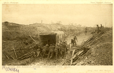 Federation University Historical Collection
Postcard - black and white, Daily Mail War Pictures, Helping an Ambulance Through the Mud, c1917
... of 40 Bridge Street, Ballarat East. Ernest Dark was a very... Bridge Street, Ballarat East. Ernest Dark was a very early World ...Ernest William Dark was born at Ballarat East. Before his enlistment on 10 April 1915, aged 19, Dark was a boot salesman. His next of kin on the enlistment papers was his mother Sarah Dark of 40 Bridge Street, Ballarat East. Ernest Dark was a very early World War One enlistment with the regimental number of 19A. He was a member of the 6th Field Ambulance. Black and white photograph of soldiers pushing an ambulance through the mud during World War One. The scene is most probably in France. Verso: "Dear Miss Holmes, I am sending this P.C. to thank you for a pair of sox which I received from the red cross, (sic) with a note inside on which was your your name and address. My unit, the 6th Aus. Field Ambulance, had received quite a lot of red cross goods from the Ballarat district, and I am writing to let you know how much the boys appreciate them. Please accept my best thanks. Yours sincerely. Pte E.W. Darkchatham, chatham family collection, ernest dark, dark, world war one, world war i. world war 1, ambulance -
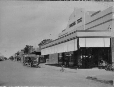 Tatura Irrigation & Wartime Camps Museum
Photos, Hogan Street Tatura
... Early Tatura photos emailed.|Hogan Street looking east from...Tatura Irrigation & Wartime Camps Museum 49 Hogan Street ...Early Tatura photos emailed.|Hogan Street looking east from railway line, c.1910.|Flanagans Store c.1935, showing shop on corner and possibly the first fire station on N.E. corner of Ross & Hogan Streets.|Hogan Street looking west from railway line c.1910(2).|Flanagans' Store on cnr. Ross and Hogan Streets, c.1910.tatura, hogan street, flanagans store, local, history -
 Ballarat Tramway Museum
Postcard, Commonwealth of Australia, Sturt St Ballarat, c1910
... on the corner of Sturt and Lydiard Streets, looking east towards... side of the street Yields information about Sturt Street east ...Image is taken from the National Mutual building on the corner of Sturt and Lydiard Streets, looking east towards Grenville St. Has an ESCo tram with blinds drawn nearing the intersection. The tramcar number could be 12, 13 or 18. There are a number of horse drawn cabs in the photograph. The Burns statue is on the left side. There are telegraph/telephone poles in the photograph along with the buildings on either side of the streetYields information about Sturt Street east of Lydiard St.Black and white postcard with a green (18mm wide) border acting as a frame to the postcard picture. The picture measures 50mm High x 98mm wide. Has a Victorian Two Pence stamp with a "168" cancellation stamp. The card has been published by the Commonwealth of Australia with a coat of Arms. In the bottom left hand corner is a symbol "HB" within an artists paint palette.On rear is a note to a Miss Audersau of Launceston.sturt st, grenville st, esco, horse cabs, trams, tramways, ballarat -
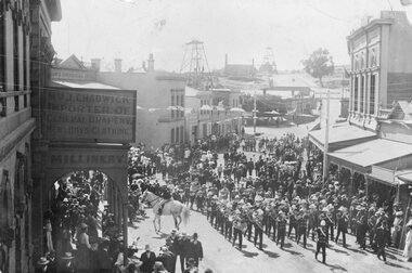 Stawell Historical Society Inc
Photograph, Upper Main Street Stawell procession with the band & a police constable on Horseback visible c1901
... Main Street Procession East End Circa 1901. Stawell Brass... grampians Main Street Procession East End Circa 1901. Stawell Brass ...Main Street Procession East End Circa 1901. Stawell Brass Band plus Constable on Horseback visible. J Chadwick Importer of General Drapery with Boys Clothing on sign on left. Millinery on side of verandah. Commercial Hotel just visible on left. Sloane's & Scotchmans Poppet head Visible in background on right. Poppet Head in background on Big Hill on left is Crown Cross shaft.Croud of people lead by band in upper main street. Chadwick drapers on left. Mounted policeman on horseback in front of Commercial Hotel.stawell businesses streetscape -
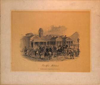 Melbourne Tram Museum
Drawing - early Melbourne CBD scenes, Sands & Kenny Melbourne & Sydney, 1856
... Bay Railway) 3 - Collins Street looking east from Wesleyan... Railway) 3 - Collins Street looking east from Wesleyan Chapel ...Set of three prints of Melbourne street scenes published by Sands & Kenny in 1856 1 - Post Office 2 - Princes Bridge and city terminus of M&HB Railway Melbourne (Melbourne and Hobsons Bay Railway) 3 - Collins Street looking east from Wesleyan Chapel Melbourne (near Queens St) Shows typical horse-drawn transport, railway and pedestrians of the era.Yields infomaition about Melbourne in 1856.Set of three prints or lithographs of drawings of early Melbourne scenes on paper.melbourne, horses, horse drawn vehicles, collins st, post office, princes bridge, railways, m&hbr -
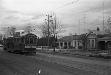 Ballarat Tramway Museum
Photograph - Black & White Photograph/s, David Endacott, 14/08/1971 12:00:00 AM
... Victorian houses on the east side of the street in the photograph..... Photo has two Victorian houses on the east side of the street ...Black and white photograph and negative of tram 35 in Drummond St. South, with destination of Sebastopol.. Photo has two Victorian houses on the east side of the street in the photograph. Probably taken 14/8/1971. Duplicate print (1264) by John Phillips 12/99. Two copies (large size) added 5/2001. Original neg scanned at hi res and updated 11/5/2020.trams, tramways, ballarat, drummond st. sth, tram 35