Showing 1323 items matching "layout"
-
 Kew Historical Society Inc
Plan, Melbourne & Metropolitan Board of Works : Borough of Kew : Detail Plan No.1563, 1905
The Melbourne and Metropolitan Board of Works (MMBW) plans were produced from the 1890s to the 1950s. They were crucial to the design and development of Melbourne's sewerage and drainage system. The plans, at a scale of 40 feet to 1 inch (1:480), provide a detailed historical record of Melbourne streetscapes and environmental features. Each plan covers one or two street blocks (roughly six streets), showing details of buildings, including garden layouts and ownership boundaries, and features such as laneways, drains, bridges, parks, municipal boundaries and other prominent landmarks as they existed at the time each plan was produced. (Source: State Library of Victoria)This plan forms part of a large group of MMBW plans and maps that was donated to the Society by the Mr Poulter, City Engineer of the City of Kew in 1989. Within this collection, thirty-five hand-coloured plans, backed with linen, are of statewide significance as they include annotations that provide details of construction materials used in buildings in the first decade of the 20th century as well as additional information about land ownership and usage. The copies in the Public Record Office Victoria and the State Library of Victoria are monochrome versions which do not denote building materials so that the maps in this collection are invaluable and unique tools for researchers and heritage consultants. A number of the plans are not held in the collection of the State Library of Victoria so they have the additional attribute of rarity.Original survey plan, issued by the MMBW to a contractor with responsibility for constructing sewers in the area identified on the plan within the Borough of Kew. The plan was at some stage hand-coloured, possibly by the contractor, but more likely by officers working in the Engineering Department of the Borough and later Town, then City of Kew. The hand-coloured sections of buildings on the plan were used to denote masonry or brick constructions (pink), weatherboard constructions (yellow), and public buildings (grey). This plan covers the area between Barkers Road, Wrixon Street, Sackville Street and Brougham Place, much of it now occupied by Carey Baptist Grammar and Preshil schools. This was an area of large and prestigious homes in 1903, some with formally laid-out gardens, such as ‘Tower Hill’ and ‘Opawa’. ‘Kalimna’ was built in 1890-91 for William H. Jarman, an accountant, and ‘Blackhall’ at the same time for W.H. Roberts. Blackhall was to be acquired by the Salvation Army in 1915 and renamed ‘Catherine Booth Girls’ Home’. The Home accommodated girls, aged between 4 and 16. Kalimna and Blackhall are of significance as typical and intact late Victorian mansions and as such are two key Victorian buildings to have been built in Kew. Both Blackhall and Kalimna are now part of Preshil. ‘Fairview’ was for a long time occupied by the Sisters of St. Joseph of Cluny as a care home for the elderly, but it is now part of Carey Grammar School, as are the grounds of ‘Wagga Merne’, ‘Weemutta’, ‘Blakely’, ‘Daheim’ and ‘Mildura’ (later ‘Urangeline’), the last being particularly impressive in 1903, with a tennis court, conservatory, outhouses, and two bathrooms!melbourne and metropolitan board of works, detail plans, mmbw 1563, cartography -
 Kew Historical Society Inc
Plan, Melbourne & Metropolitan Board of Works : Borough of Kew : Detail Plan No.1564, 1905
The Melbourne and Metropolitan Board of Works (MMBW) plans were produced from the 1890s to the 1950s. They were crucial to the design and development of Melbourne's sewerage and drainage system. The plans, at a scale of 40 feet to 1 inch (1:480), provide a detailed historical record of Melbourne streetscapes and environmental features. Each plan covers one or two street blocks (roughly six streets), showing details of buildings, including garden layouts and ownership boundaries, and features such as laneways, drains, bridges, parks, municipal boundaries and other prominent landmarks as they existed at the time each plan was produced. (Source: State Library of Victoria)This plan forms part of a large group of MMBW plans and maps that was donated to the Society by the Mr Poulter, City Engineer of the City of Kew in 1989. Within this collection, thirty-five hand-coloured plans, backed with linen, are of statewide significance as they include annotations that provide details of construction materials used in buildings in the first decade of the 20th century as well as additional information about land ownership and usage. The copies in the Public Record Office Victoria and the State Library of Victoria are monochrome versions which do not denote building materials so that the maps in this collection are invaluable and unique tools for researchers and heritage consultants. A number of the plans are not held in the collection of the State Library of Victoria so they have the additional attribute of rarity.Original survey plan, issued by the MMBW to a contractor with responsibility for constructing sewers in the area identified on the plan within the Borough of Kew. The plan was at some stage hand-coloured, possibly by the contractor, but more likely by officers working in the Engineering Department of the Borough and later Town, then City of Kew. The hand-coloured sections of buildings on the plan were used to denote masonry or brick constructions (pink), weatherboard constructions (yellow), and public buildings (grey). In 1905, when Plan No.1564 was printed, that part of Kew bordered by Brougham Place (now Daniell Place), Mount Street, Sackville Street and Ross Street was already the location of a number of large mansions. Here, subdivisions, at least at this stage, produced larger blocks than in Central Kew. Many of the houses on this plan are named: ‘Faybrook’, ‘Northumbria’, ‘Parkholm[e]’, ‘Dunboe’, ‘Katoomba’ and ‘Eschol’ fronting Sackville Street. Eschol was once the home of the manufacturer Robert Harrison, whose cordial factory in Spring and Argyle Streets Fitzroy are noted on the Victorian Heritage Register. ‘The Hawthorns’ on the corner of Brougham Place and Mount Street was the home of the medical practitioner Frank William Fay, who won the military cross and other honours for conspicuous gallantry and devotion to duty in World War 1.melbourne and metropolitan board of works, detail plans, mmbw 1564, cartography -
 Kew Historical Society Inc
Plan, Melbourne & Metropolitan Board of Works : Borough of Kew : Detail Plan No.1565, 1905
The Melbourne and Metropolitan Board of Works (MMBW) plans were produced from the 1890s to the 1950s. They were crucial to the design and development of Melbourne's sewerage and drainage system. The plans, at a scale of 40 feet to 1 inch (1:480), provide a detailed historical record of Melbourne streetscapes and environmental features. Each plan covers one or two street blocks (roughly six streets), showing details of buildings, including garden layouts and ownership boundaries, and features such as laneways, drains, bridges, parks, municipal boundaries and other prominent landmarks as they existed at the time each plan was produced. (Source: State Library of Victoria). This plan forms part of a large group of MMBW plans and maps that was donated to the Society by the Mr Poulter, City Engineer of the City of Kew in 1989. Within this collection, thirty-five hand-coloured plans, backed with linen, are of statewide significance as they include annotations that provide details of construction materials used in buildings in the first decade of the 20th century as well as additional information about land ownership and usage. The copies in the Public Record Office Victoria and the State Library of Victoria are monochrome versions which do not denote building materials so that the maps in this collection are invaluable and unique tools for researchers and heritage consultants. A number of the plans are not held in the collection of the State Library of Victoria so they have the additional attribute of rarity.Original survey plan, issued by the MMBW to a contractor with responsibility for constructing sewers in the area identified on the plan within the Borough of Kew. The plan was at some stage hand-coloured, possibly by the contractor, but more likely by officers working in the Engineering Department of the Borough and later Town, then City of Kew. The hand-coloured sections of buildings on the plan were used to denote masonry or brick constructions (pink), weatherboard constructions (yellow), and public buildings (grey). MMBW Plan No.1565 is an example of a plan where a number of streets have been created since the area was surveyed, or in other cases renamed. The plan shows those streets that were bordered by Ross Street, Mount Street, Sackville Street and Burke Road. Since 1905, Mawson Street has been created and Mont Albert Road renamed as Dean Street. Named houses on the plan include ‘Tyrol’, ‘Glengorse’, ‘Theodore Villa’, ‘Arncliffe’, ‘Ballynira’ and ‘Hazeldene’. The plan also shows a Wesleyan Church in Sackville Street. In 1883, the Church’s Sunday School celebrated its silver anniversary.melbourne and metropolitan board of works, detail plans, mmbw 1565, cartography -
 Kew Historical Society Inc
Plan, Melbourne & Metropolitan Board of Works : Borough of Kew : Detail Plan No.1568, 1905
The Melbourne and Metropolitan Board of Works (MMBW) plans were produced from the 1890s to the 1950s. They were crucial to the design and development of Melbourne's sewerage and drainage system. The plans, at a scale of 40 feet to 1 inch (1:480), provide a detailed historical record of Melbourne streetscapes and environmental features. Each plan covers one or two street blocks (roughly six streets), showing details of buildings, including garden layouts and ownership boundaries, and features such as laneways, drains, bridges, parks, municipal boundaries and other prominent landmarks as they existed at the time each plan was produced. (Source: State Library of Victoria)This plan forms part of a large group of MMBW plans and maps that was donated to the Society by the Mr Poulter, City Engineer of the City of Kew in 1989. Within this collection, thirty-five hand-coloured plans, backed with linen, are of statewide significance as they include annotations that provide details of construction materials used in buildings in the first decade of the 20th century as well as additional information about land ownership and usage. The copies in the Public Record Office Victoria and the State Library of Victoria are monochrome versions which do not denote building materials so that the maps in this collection are invaluable and unique tools for researchers and heritage consultants. A number of the plans are not held in the collection of the State Library of Victoria so they have the additional attribute of rarity.Original survey plan, issued by the MMBW to a contractor with responsibility for constructing sewers in the area identified on the plan within the Borough of Kew. The plan was at some stage hand-coloured, possibly by the contractor, but more likely by officers working in the Engineering Department of the Borough and later Town, then City of Kew. The hand-coloured sections of buildings on the plan were used to denote masonry or brick constructions (pink), weatherboard constructions (yellow), and public buildings (grey). Plan No.1568 covers the area bounded by Cotham Road, John Street, Sackville Street, and Edward Street. Alfred Street and Rowland Street are in shown in the middle of the plan. The two most notable buildings shown are ‘St Helliers’, the home of the Dumaresq family, and St Hilary’s Church and school. While the colours used to indicate St Hilary’s are grey as in other civic/public buildings, the first St Hilary’s Anglican Church was at this stage constructed in weatherboard. At the left of the plan, facing Sackville Street is a house named ‘Glencara’. The 1988 ‘Kew Conservation Study’ recorded that “The first documentary evidence of this house comes from Rate Books which record that in 1893 a Mrs Treadway was the owner of this building with an N.A.V. of £81? At that date the occupier of the house was Charles B. Kelly, a clerk, while by 1910 Kelly had become the owner of the property described in that year ‘as a six-roomed stone, brick and wood house with stables and outbuildings’”. Contrary to this description, the 1905 plan indicates that the house was entirely constructed of masonry.melbourne and metropolitan board of works, detail plans, mmbw 1568 -
 Kew Historical Society Inc
Plan, Melbourne & Metropolitan Board of Works : Borough of Kew : Detail Plan No.1569, 1905
The Melbourne and Metropolitan Board of Works (MMBW) plans were produced from the 1890s to the 1950s. They were crucial to the design and development of Melbourne's sewerage and drainage system. The plans, at a scale of 40 feet to 1 inch (1:480), provide a detailed historical record of Melbourne streetscapes and environmental features. Each plan covers one or two street blocks (roughly six streets), showing details of buildings, including garden layouts and ownership boundaries, and features such as laneways, drains, bridges, parks, municipal boundaries and other prominent landmarks as they existed at the time each plan was produced. (Source: State Library of Victoria)This plan forms part of a large group of MMBW plans and maps that was donated to the Society by the Mr Poulter, City Engineer of the City of Kew in 1989. Within this collection, thirty-five hand-coloured plans, backed with linen, are of statewide significance as they include annotations that provide details of construction materials used in buildings in the first decade of the 20th century as well as additional information about land ownership and usage. The copies in the Public Record Office Victoria and the State Library of Victoria are monochrome versions which do not denote building materials so that the maps in this collection are invaluable and unique tools for researchers and heritage consultants. A number of the plans are not held in the collection of the State Library of Victoria so they have the additional attribute of rarity.Original survey plan, issued by the MMBW to a contractor with responsibility for constructing sewers in the area identified on the plan within the Borough of Kew. The plan was at some stage hand-coloured, possibly by the contractor, but more likely by officers working in the Engineering Department of the Borough and later Town, then City of Kew. The hand-coloured sections of buildings on the plan were used to denote masonry or brick constructions (pink), weatherboard constructions (yellow), and public buildings (grey). This plan covers parts of Sackville Street, John Street, Thomas Street and Cotham Road, and includes several very large houses in Sackville Street. Job Smith built ‘Berrington’ in about 1888-90 for himself, and ‘Pomeroy’ (now ‘Merridale’) in 1885 for James Mickleburgh. ‘Heathfield’ was built in 1888 for Henry Eeles, and was one of many fine homes in Kew, Hawthorn and surrounding suburbs designed by prolific architect John Beswicke; it later became “La Verna” and was a Franciscan monastery. Similarly, in Cotham Road, we can see ‘Bella Vista’ (now demolished), and ‘Charleville’, with its double-storeyed arcade frontage, built in 1889 for Charles Donaldson whose family occupied it until 1939. This was renamed ‘Ross House’ by the second owner, Dr. Thomas King, and then substantially restored in the 1960s by the Stillwell family, well known as car drivers and dealers. Bella Vista (later ‘Malinda’) was originally designed by the architect Robert Haddon and built for Abel Hoadley, inventor of the Violet Crumble Bar and many other delicious delicacies. He began by manufacturing jams and pickles in South Melbourne using fruit from his own orchard in East Burwood.melbourne and metropolitan board of works, detail plans, mmbw 1569, cartography -
 Kew Historical Society Inc
Plan, Melbourne & Metropolitan Board of Works : Borough of Kew : Detail Plan No.1571, 1904
The Melbourne and Metropolitan Board of Works (MMBW) plans were produced from the 1890s to the 1950s. They were crucial to the design and development of Melbourne's sewerage and drainage system. The plans, at a scale of 40 feet to 1 inch (1:480), provide a detailed historical record of Melbourne streetscapes and environmental features. Each plan covers one or two street blocks (roughly six streets), showing details of buildings, including garden layouts and ownership boundaries, and features such as laneways, drains, bridges, parks, municipal boundaries and other prominent landmarks as they existed at the time each plan was produced. (Source: State Library of Victoria)This plan forms part of a large group of MMBW plans and maps that was donated to the Society by the Mr Poulter, City Engineer of the City of Kew in 1989. Within this collection, thirty-five hand-coloured plans, backed with linen, are of statewide significance as they include annotations that provide details of construction materials used in buildings in the first decade of the 20th century as well as additional information about land ownership and usage. The copies in the Public Record Office Victoria and the State Library of Victoria are monochrome versions which do not denote building materials so that the maps in this collection are invaluable and unique tools for researchers and heritage consultants. A number of the plans are not held in the collection of the State Library of Victoria so they have the additional attribute of rarity.Digital copy of the original survey plan, issued by the MMBW to a contractor with responsibility for constructing sewers in the area identified on the plan within the Borough of Kew. The plan was at some stage hand-coloured, possibly by the contractor, but more likely by officers working in the Engineering Department of the Borough and later Town, then City of Kew. The hand-coloured sections of buildings on the plan were used to denote masonry or brick constructions (pink), weatherboard constructions (yellow), and public buildings (grey). This plan is part of a large and historically significant group of MMBW plans and maps that was donated to the Society by the Mr Poulter, City Engineer of the City of Kew in 1989. When the contracts were let for surveyors to identify and record the extant houses and landscapes within an area for the Board of Works, the contracts were let at separate times, hence the anomaly where two copies of Plan No.1571 exist in our collection. The first of these plans identifies the building materials used in houses bordering Fitzwilliam Street, Edgevale Road, May Street, Malin Street, Davis Street and Wellington Street. The cut off point for the survey was the south side of Wellington Street. By 1903 when the survey was undertaken many of the sites were already built on, particularly those facing Edgevale Road. The plan identifies the preponderance of weatherboard houses in the area. The other version of the plan identifies the buildings between Wellington Street and Cotham Road.melbourne and metropolitan board of works, detail plans, mmbw 1571, cartography -
 Kew Historical Society Inc
Plan, Melbourne & Metropolitan Board of Works : Borough of Kew : Detail Plan No.1571, 1904
The Melbourne and Metropolitan Board of Works (MMBW) plans were produced from the 1890s to the 1950s. They were crucial to the design and development of Melbourne's sewerage and drainage system. The plans, at a scale of 40 feet to 1 inch (1:480), provide a detailed historical record of Melbourne streetscapes and environmental features. Each plan covers one or two street blocks (roughly six streets), showing details of buildings, including garden layouts and ownership boundaries, and features such as laneways, drains, bridges, parks, municipal boundaries and other prominent landmarks as they existed at the time each plan was produced. (Source: State Library of Victoria)This plan forms part of a large group of MMBW plans and maps that was donated to the Society by the Mr Poulter, City Engineer of the City of Kew in 1989. Within this collection, thirty-five hand-coloured plans, backed with linen, are of statewide significance as they include annotations that provide details of construction materials used in buildings in the first decade of the 20th century as well as additional information about land ownership and usage. The copies in the Public Record Office Victoria and the State Library of Victoria are monochrome versions which do not denote building materials so that the maps in this collection are invaluable and unique tools for researchers and heritage consultants. A number of the plans are not held in the collection of the State Library of Victoria so they have the additional attribute of rarity.Original survey plan, issued by the MMBW to a contractor with responsibility for constructing sewers in the area identified on the plan within the Borough of Kew. The plan was at some stage hand-coloured, possibly by the contractor, but more likely by officers working in the Engineering Department of the Borough and later Town, then City of Kew. The hand-coloured sections of buildings on the plan were used to denote masonry or brick constructions (pink), weatherboard constructions (yellow), and public buildings (grey). This plan is the other half of Plan No.1571 representing the constructions to the west of Wellington Street before and in 1903/4. This plan represents the built environment in Edgevale Road, Wellington Street, Atkins Street, Annadale Street, Mortimer Street, and Cotham Road. Whereas there are smaller allotments and more modest housing stock facing Edgevale Road, larger blocks and more substantial houses are represented facing Cotham Road.melbourne and metropolitan board of works, detail plans, mmbw 1571, cartography -
 Kew Historical Society Inc
Plan, Melbourne & Metropolitan Board of Works : Borough of Kew : Detail Plan No.1572, 1905
The Melbourne and Metropolitan Board of Works (MMBW) plans were produced from the 1890s to the 1950s. They were crucial to the design and development of Melbourne's sewerage and drainage system. The plans, at a scale of 40 feet to 1 inch (1:480), provide a detailed historical record of Melbourne streetscapes and environmental features. Each plan covers one or two street blocks (roughly six streets), showing details of buildings, including garden layouts and ownership boundaries, and features such as laneways, drains, bridges, parks, municipal boundaries and other prominent landmarks as they existed at the time each plan was produced. (Source: State Library of Victoria)This plan forms part of a large group of MMBW plans and maps that was donated to the Society by the Mr Poulter, City Engineer of the City of Kew in 1989. Within this collection, thirty-five hand-coloured plans, backed with linen, are of statewide significance as they include annotations that provide details of construction materials used in buildings in the first decade of the 20th century as well as additional information about land ownership and usage. The copies in the Public Record Office Victoria and the State Library of Victoria are monochrome versions which do not denote building materials so that the maps in this collection are invaluable and unique tools for researchers and heritage consultants. A number of the plans are not held in the collection of the State Library of Victoria so they have the additional attribute of rarity.Original survey plan, issued by the MMBW to a contractor with responsibility for constructing sewers in the area identified on the plan within the Borough of Kew. The plan was at some stage hand-coloured, possibly by the contractor, but more likely by officers working in the Engineering Department of the Borough and later Town, then City of Kew. The hand-coloured sections of buildings on the plan were used to denote masonry or brick constructions (pink), weatherboard constructions (yellow), and public buildings (grey). Plan No. 1572 represents the built environment bordered by Barkers Road, Wrixon Street, Edgevale Road and Fitzwilliam Street. Other streets identified on the plan include Stansell Street. Plan 1572 shows that by 1903-05, there was only patchy development in this area of Kew, mainly on Edgevale Road and Fitzwilliam Street. Only two named houses are identified: the quaintly named ‘Tweed Cottage’, and ‘Mendip’. The earliest reference to Treed Cottage in Australian newspapers is to the death of Walter Thompson, aged 74 who was a resident there in 1885. His youngest daughter was to die there in 1908. Mendip to the north of Tweed Cottage was owned by Henry Thompson; he was to die in 1901; his wife in 1932. At this period of time, Malin Street and Clivedon Court did not extend to Barkers Road.melbourne and metropolitan board of works, detail plans, mmbw 1572, cartography -
 Kew Historical Society Inc
Plan, Melbourne & Metropolitan Board of Works : Borough of Kew : Detail Plan No.1573, 1905
The Melbourne and Metropolitan Board of Works (MMBW) plans were produced from the 1890s to the 1950s. They were crucial to the design and development of Melbourne's sewerage and drainage system. The plans, at a scale of 40 feet to 1 inch (1:480), provide a detailed historical record of Melbourne streetscapes and environmental features. Each plan covers one or two street blocks (roughly six streets), showing details of buildings, including garden layouts and ownership boundaries, and features such as laneways, drains, bridges, parks, municipal boundaries and other prominent landmarks as they existed at the time each plan was produced. (Source: State Library of Victoria)This plan forms part of a large group of MMBW plans and maps that was donated to the Society by the Mr Poulter, City Engineer of the City of Kew in 1989. Within this collection, thirty-five hand-coloured plans, backed with linen, are of statewide significance as they include annotations that provide details of construction materials used in buildings in the first decade of the 20th century as well as additional information about land ownership and usage. The copies in the Public Record Office Victoria and the State Library of Victoria are monochrome versions which do not denote building materials so that the maps in this collection are invaluable and unique tools for researchers and heritage consultants. A number of the plans are not held in the collection of the State Library of Victoria so they have the additional attribute of rarity.Original survey plan, issued by the MMBW to a contractor with responsibility for constructing sewers in the area identified on the plan within the Borough of Kew. The plan was at some stage hand-coloured, possibly by the contractor, but more likely by officers working in the Engineering Department of the Borough and later Town, then City of Kew. The hand-coloured sections of buildings on the plan were used to denote masonry or brick constructions (pink), weatherboard constructions (yellow), and public buildings (grey). This plan has detailed annotations written in red or blue ink, showing prices, which may be the annual valuations of the properties, and some owners’ names, a most unusual feature on contractor's maps. Some areas, such as the buildings of Methodist Ladies’ College (MLC), include the school’s tennis court and swimming pool, but are not coloured to show building materials – did the draftsman just run out of time, or ink, or enthusiasm, before his plan had to be submitted? MLC had been founded in 1882 as a ‘modern school of the first order’ with buildings that formed ‘a collegiate institution for girls unsurpassed in the colonies’. The goal of its founders was to provide a high-class Christian education for girls, comparable with that provided elsewhere for boys. Some shops are shown along Edgevale Road, though they are not designated as commercial premises. Larger houses are depicted, including ‘Fairlawn’ in Barkers Road, and ‘Clevedon’ and ‘Rosehill’ (now demolished) in Fitzwilliam Street.melbourne and metropolitan board of works, detail plans, mmbw 1573, maps - borough of kew, cartography -
 Kew Historical Society Inc
Plan, Melbourne & Metropolitan Board of Works : Borough of Kew : Detail Plan No.1574, 1905
The Melbourne and Metropolitan Board of Works (MMBW) plans were produced from the 1890s to the 1950s. They were crucial to the design and development of Melbourne's sewerage and drainage system. The plans, at a scale of 40 feet to 1 inch (1:480), provide a detailed historical record of Melbourne streetscapes and environmental features. Each plan covers one or two street blocks (roughly six streets), showing details of buildings, including garden layouts and ownership boundaries, and features such as laneways, drains, bridges, parks, municipal boundaries and other prominent landmarks as they existed at the time each plan was produced. (Source: State Library of Victoria)This plan forms part of a large group of MMBW plans and maps that was donated to the Society by the Mr Poulter, City Engineer of the City of Kew in 1989. Within this collection, thirty-five hand-coloured plans, backed with linen, are of statewide significance as they include annotations that provide details of construction materials used in buildings in the first decade of the 20th century as well as additional information about land ownership and usage. The copies in the Public Record Office Victoria and the State Library of Victoria are monochrome versions which do not denote building materials so that the maps in this collection are invaluable and unique tools for researchers and heritage consultants. A number of the plans are not held in the collection of the State Library of Victoria so they have the additional attribute of rarity.Original survey plan, issued by the MMBW to a contractor with responsibility for constructing sewers in the area identified on the plan within the Borough of Kew. The plan was at some stage hand-coloured, possibly by the contractor, but more likely by officers working in the Engineering Department of the Borough and later Town, then City of Kew. The hand-coloured sections of buildings on the plan were used to denote masonry or brick constructions (pink), weatherboard constructions (yellow), and public buildings (grey). This plan shows several very large houses, particularly along Glenferrie Road, and the area now occupied by Ruyton Girls’ School. ‘Tarring’ (incorrectly spelled here as ‘Karring’) was built for Henry Henty in 1872, on part of his original allotment of 20 acres, and ‘Mount View’, which retains its original building and the fountain in the front garden, is part of Ruyton’s Junior School. The most significant change to Tarring and its grounds since 1903, involve the removal of a number of the outbuildings, including a Burmese temple, bought by Henty from the Burmese Exhibit at the Great Exhibition of 1880. It is shown on the plan as a summerhouse. The two-storey mansion, on the corner of Glenferrie Road and Wellington Street, was built in 1891 by leading architect Alfred White as his own home. Having an initial N.A.V. of £160, the house was purchased by a warehouseman Henry Lister, by 1900, when the N.A.V. was recorded at £111. By the turn of the century the house was known as ‘Comaques’. By contrast, much smaller houses are shown in Scott and Byron Streets, including a tiny Mission Hall in Byron Street, which belonged to the Anglican Church from at least 1903 to 1917.melbourne and metropolitan board of works, detail plans, maps - borough of kew, mmbw 1574, cartography -
 Kew Historical Society Inc
Plan, Melbourne & Metropolitan Board of Works : Borough of Kew : Detail Plan No.1575, 1905
The Melbourne and Metropolitan Board of Works (MMBW) plans were produced from the 1890s to the 1950s. They were crucial to the design and development of Melbourne's sewerage and drainage system. The plans, at a scale of 40 feet to 1 inch (1:480), provide a detailed historical record of Melbourne streetscapes and environmental features. Each plan covers one or two street blocks (roughly six streets), showing details of buildings, including garden layouts and ownership boundaries, and features such as laneways, drains, bridges, parks, municipal boundaries and other prominent landmarks as they existed at the time each plan was produced. (Source: State Library of Victoria)This plan forms part of a large group of MMBW plans and maps that was donated to the Society by the Mr Poulter, City Engineer of the City of Kew in 1989. Within this collection, thirty-five hand-coloured plans, backed with linen, are of statewide significance as they include annotations that provide details of construction materials used in buildings in the first decade of the 20th century as well as additional information about land ownership and usage. The copies in the Public Record Office Victoria and the State Library of Victoria are monochrome versions which do not denote building materials so that the maps in this collection are invaluable and unique tools for researchers and heritage consultants. A number of the plans are not held in the collection of the State Library of Victoria so they have the additional attribute of rarity.Original survey plan, issued by the MMBW to a contractor with responsibility for constructing sewers in the area identified on the plan within the Borough of Kew. The plan was at some stage hand-coloured, possibly by the contractor, but more likely by officers working in the Engineering Department of the Borough and later Town, then City of Kew. The hand-coloured sections of buildings on the plan were used to denote masonry or brick constructions (pink), weatherboard constructions (yellow), and public buildings (grey). Plan No.1575 shows that in the area bounded by Wellington Street, Edgevale Road, Glenferrie Road, and Cotham Road, there had already been significant subdivision of land and houses constructed. As one of the highest points in Kew, as expected, there were already some significant mansions built on large allotments of land. Many of these mansions are identified by name on the plan such as ‘Kelso’, ‘Abbotsford’, ‘Clarendon’ and ‘Ashlyn’ in Cotham Road. Other houses of equal size are unnamed on the plan.melbourne and metropolitan board of works, detail plans, maps - borough of kew, mmbw 1575, cartography -
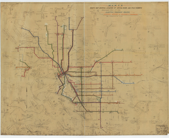 Melbourne Tram Museum
Drawing, Melbourne & Metropolitan Tramways Board (MMTB), "Route Map showing location of special work and pole numbers" "Electric Tramway Routes - showing routes in colours and numbers", late 1941
Map of the system shown at two inches = 1 mile. Drawing No. P5799. Shows crossovers, track layouts at junctions, signal cabins roads, railways and stations. Originally signed by Perway Engineer - 20/12/1940, though originally drawn in 1922. Has been marked up in coloured pencil to show the routes and route numbers. The plan shows the lines to Maribyrnong Munitions works along Cordite Ave and Wests Road and the track from Moonee Ponds to Union Road, which opened in July 1941, but not the extension to Essendon Airport built-in 1942. See Reg Item 1561 for a 1963 version and 1683 for a 1987 versionDemonstrates the use of a MMTB drawing to show tram routes and their route numbers at the time.Drawings - dyeline cloth backed print - titled - "Route Map showing location of special work and pole numbers" and subtitled - "Electric Tramway Routes - showing routes in colours and numbers". trams, tramways, mmtb, trackwork, tramways, junction, map, world war 2 -
 Bialik College
Mixed media (series) - Sites & Premises: fundraising appeals and plans for development
1990s, 2000s, 1980s, buildings, development, planning, shakespeare grove, elc, 1970s1990s, 2000s, 1980s, buildings, development, planning, shakespeare grove, elc, 1970s -
 Ballarat Tramway Museum
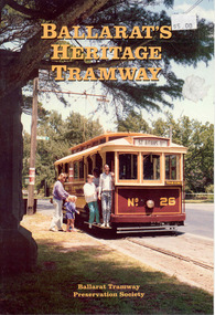
Book, W.F.Scott, "Ballarat's Heritage Tramway", 1993
Book - 28 pages, colour covers with colour and black white photos titled "Ballarat's Heritage Tramway", Tells the story of the Ballarat Tramways and the Ballarat Tramway Preservation Society. Written by W. F. Scott for the BTPS in 1993. Was an update of previous versions. Covers the history of the horse trams, the electrification by the Electric Supply Co. of Victoria, (ESCo) the takeover by the State Electricity Commission of Victoria (SECV), closure in 1971, the formation of the BTPS and the operation of the tramway. Includes a list of the Museum tramcars at the time, details of the trams, many photos and a map of the system, depot layouts. Images of each page included in the image file. See Reg item 1967 for proofs of sheets.trams, tramways, btps, btm, history -
 Melbourne Tram Museum
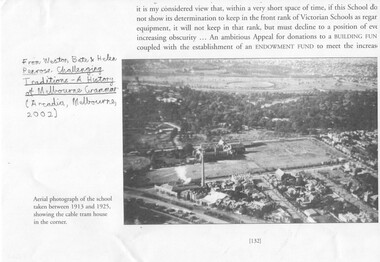
Document - Photocopies, Weston Bate and others, "Challenging Traditions - A History of Melbourne Grammar', 2016
Set of three photocopies of photographs from "Challenging Traditions - A History of Melbourne Grammar (Arcdia, Melbourne 2002) showing the cable tram winding house on the corner of St Kilda Road and Bromby St in 1919 and after redevelopment c1930. .1 - looking north with steam coming from the winding house. .2 - looking south east with winding house and surround buildings .3 - after closure and redevelopment of the site, looking north east. .4 - photo of the intersection of Victoria Parade and Gisborne St showing the cable tram track, cable trams, MFB and Eye and Ear Hospital. Shows the track layout partly. A photograph from a book "Melbourne from the Air"trams, tramways, st kilda rd, cable trams, victoria parade, brunswick st, winding houses, fitzroy -
 Melbourne Tram Museum
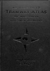
Book, Hugh Ballment, Carl Segnit, "An Illustrated Tramway Atlas of Australia and New Zealand", 2018
Book - hard cover, 9 sewn sections, full paper bound front covers, 120 pages, gloss paper printed in full colour titled "An Illustrated Tramway Atlas of Australia and New Zealand" with a table of contents by Hugh Ballment and Carl Segnit published by Transit Australia, 2018. Has a preface and acknowledgements, lists 23 Australian and 9 New Zealand cities that had public street tramway systems. Gives maps of the Tramway Museums at the time, trams on public displays and tramway museums that have closed. Includes cable trams, some horse trams, VR, Doncaster, Commonwealth Engineering test facility at Dandenong and depot layouts.trams, tramways, atlas, australian tramways, maps, commonwealth engineering, melbourne, vr, cable trams, depots -
 Ballarat Heritage Services
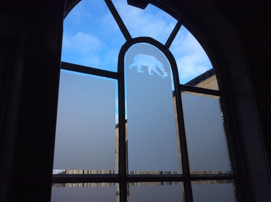
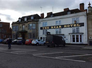
Photograph - Colour, The Bear Hotel, Devizes, England
Devizes is a medieval market town in the centre of Wiltshire, 16 miles from Stonehenge and 8 miles from Avebury. The building of a castle in Norman times dictated the layout of the town which is still visible. It contains over 50 Heritage Plaques. There were people in Devizes locality in prehistoric times and a Roman villa once stood on The green. The Wiltshire Museum is home to one of the best Broze Age collections in Britain and includes finds from around Stonehenge including the famous Bush Barrow gold. Some convicts that were tried at the Devizes Assizes were transported to Australia. Amongst these was John Chew, transported to Tasmania, but later his family settled in Victoria.devizes, the bear hotel, staircase, window -
 Ballarat Heritage Services
Photograph - Colour, The Bear Hotel, Devizes, England
Devizes is a medieval market town in the centre of Wiltshire, 16 miles from Stonehenge and 8 miles from Avebury. The building of a castle in Norman times dictated the layout of the town which is still visible. It contains over 50 Heritage Plaques. There were people in Devizes locality in prehistoric times and a Roman villa once stood on The green. The Wiltshire Museum is home to one of the best Bronze Age collections in Britain and includes finds from around Stonehenge including the famous Bush Barrow gold. Some convicts that were tried at the Devizes Assizes were transported to Australia. Amongst these was John Chew, transported to Tasmania, but later his family settled in Victoria.devizes, the bear hotel, staircase, window -
 Ballarat Heritage Services
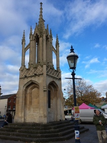
Photograph - Colour, Dorothy Wickham, Monument in Town Square, Devizes, England, 2017
Devizes is a medieval market town in the centre of Wiltshire, 16 miles from Stonehenge and 8 miles from Avebury. The building of a castle in Norman times dictated the layout of the town which is still visible. It contains over 50 Heritage Plaques. There were people in Devizes locality in prehistoric times and a Roman villa once stood on The green. The Wiltshire Museum is home to one of the best Bronze Age collections in Britain and includes finds from around Stonehenge including the famous Bush Barrow gold. Some convicts that were tried at the Devizes Assizes were transported to Australia. Amongst these was John Chew, transported to Tasmania, but later his family settled in Victoria.devizes, bear hotel, staircase, window -
 Ballarat Tramway Museum
Ephemera - Timetable/s, State Electricity Commission of Victoria (SECV), "Bendigo Tramways - amended Timetable", Jun. 1970
Set of Bendigo Tramway timetables. Each Two page Gestetner duplicated documents, stapled in the top left hand corner, providing weekday and weekend services for each route departing the city and the nominated route terminus. .1 - Issued 29/6/1970 - see images 1 and 2 .2 - issued 27/9/1971 - see image 3 and 4 .3 - issued 26/6/1970 - same as .1 - three copies held - three copies of SECV copies given to the BTPS at the time of closure. .4 - issued 29/6/1970 - different layout at heading and changes to the bottom of the second page - images 5 and 6. Yields information about Bendigo trams and their timetables for the various lines.Set of four SECV North Electricity Supply Branch timetables. 285.3 - each of three copies marked in ink - "BTPS No 502" in top right hand corner, with copy 1 having "408" crossed out.bendigo, secv, timetables, tram services -
 Kew Historical Society Inc
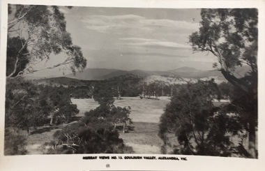
Postcard, Murray Views, Murray Views No.13 - Goulburn Valley, Alexandra, Vic, 1920-1955
The Kew Historical Society's postcard collection includes views of Kew, Melbourne and Greater Melbourne as well as those including overseas scenes sent or received from Europe or the Middle East. They date from the 1890s to the 2000s. These postcards may or may not include the name of the publisher or printer. A number of the cards were published as parts of popular series. A way of dating early postcards is to identify whether the reverse was divided by a central line which became the norm after 1902 in the United Kingdom. However, other postcards produced after this date do not always conform to this print layout. Murray Views is an Australian company, founded in 1908 by Fred Murray in Gympie, Queensland.Monochrome postcard of the Goulburn Valley near Alexandra, Victoriaalexandra - victoria, goulburn valley - victoria, postcards -- goulburn valley (vic.) -
 Melbourne Tram Museum
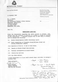
Letter, Metropolitan Transit Authority (MTA), "North - South Light Rail", 12/1986
Letter from Geoff Carkeek, MTA Tram and Bus Division General Manager to J Harper, Secretary ATMOEA dated 24/12/1986 regarding the North - South Light Rail proposal (St Kilda and Port Melbourne lines) and the conversion to light rail, and impacts on existing tram services. Includes a note on the proposed termination of route 15 and 16 trams at St Kilda Railway station. Includes two drawings - St Kilda Station - Fitzroy St using the former VR St Kilda station forecourt rather than the platforms which were actually later used, and Clarendon St - Port Junction layout.Yields information about the conversion of the St Kilda Railway project.Letter - photocoped - 6 A4 and 2 A3 folded sheets, part stapled.light rail, conversion, st kilda, port junction, atmoea, st kilda railway station -
 Ringwood and District Historical Society
Map - State Aerial Survey, Dandenong Ranges Area, Parishes of Warrandyte and Ringwood - 1956
Map of central and southern areas of Ringwood and part of Ringwood East and Heathmont compiled by Dept of Lands and Survey, July 1956, from aerial photographs and Cadastral Survey information. Subsequent hand-drawn addition of streets showing layout of "Township of Ballyduffy Estate 1858-60", an earlier proposed subdivision that did not eventuate. (See attached 5009b Ballyshanassy_ Melbourne’s lost suburb.pdf for Ballyduffy historical naming relevance). Ballyduffy Estate streets include City Road, West Prussia Road, Duffy Street, Ireland Street, Evans Street, Victoria Street, Regina Street, Short Road, Prussia Road, Duffy Street East, Ireland Street East, Evans Street East, Chapman Street. Misc Topo 93 Sheet 22, Ringwood A4B2. Scale: 4 chains to 1 inch. Contour interval 20 feet. -
 Ballarat Tramway Museum
Functional object - Destination Roll, State Electricity Commission of Victoria (SECV), "Ballarat" (black background), 1960s
Yields information and demonstrates aspects about Ballarat's destination rolls used in trams up to 1967 when the rolls were replaced with the opposite colour arrangementDestination roll white lettering on black background used in Ballarat until late 1967, replaced by black letters on white background. Layout of individual destinations follows that shown in K.S.Kings, "Ballarat Tramways" - see image file for copy. Main letters are 150 high. Has a short section of white on the top of the roll and larger section at bottom. On rear of roll, has abbreviated destinations painted in white paint on black gloss paint to enable drivers to locate easier the individual destinations. Width - used on bogie trams? See also Reg Item 844 for another example - single truck roll and K.S.Kings "Ballarat Tramways" Not to be used in a tramcar destination box - original to be kept in archives.tram, trams, ballarat, destination roll -
 Melbourne Tram Museum
Document - Research Notes, H. S. McComb, "MMTB Tramways Constructed and/or Operated", authorized by statute" and Authorized but not Constructed", 1930 to 1955
Handwritten lists of tramways built, or not constructed listed on full foolscap sheets: .1 - "MMTB Tramways Constructed and/or Operated" - 14 sheets giving street, municipality, extent, whether horse, cable, electric or omnibus with authorisation, date opened and notes. .2 - "Tramways Authorized by Statute" - 24 sheets + 6 unused sheets - listing street, municipality, extent, whether horse, cable, electric, reference to the actual Act and remarks. Includes lines for the Williamstown area. .3 - "MMTB Tramways Authorized but not Constructed" - 2 sheets - giving street, municipality, extent, whether horse, cable, electric or omnibus with authorisation, date opened and notes. Includes a plain sheet of paper giving a trial layout for the form.trams, tramways, mto co, cable trams, parliament, acts of parliament, order in council, regulations, mmtb, tramways, railways, buses, horse trams -
 Ringwood and District Historical Society
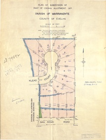
Document - Real Estate Folder, Savernake Estate, Ringwood, Victoria - Stage two - circa 1967
Plan of Subdivision PS79692, Part of Crown Allotment 31A Parish of Warrandyte, and advertisement for sale of residential allotments with map showing layout of Stage 2 of subdivision. Typewritten details for first and second release of Lots 10 to 16 with Terms of sale, stapled to two advertising flyers featuring map of estate showing Lots 1 to 20 on Evelyn Road, Cameron Road, Klead Court, and San Remo Road. Green slip included dated 6 July 1979 showing description of property at Lot 14 (no.4) San Remo Road, vendor - Judith Margaret Love and Lindsale Stephen Love, Cherry Tree Downs, Tarwin Lower 3456. Phone 056635390 Bus 056787203.Agent - C.E. Carter & Son, R.E.S.I. 126 Whitehorse Road, Ringwood. Telephones: 8706024, 8706830, 8702519, A.H.: 7233298, 8782648. Subdivision Plan stamped Donald Cameron Consultants Pty. Ltd., Consulting Engineers, 472 Bourke Street Melbourne - 67-2602. -
 Ballarat Tramway Museum
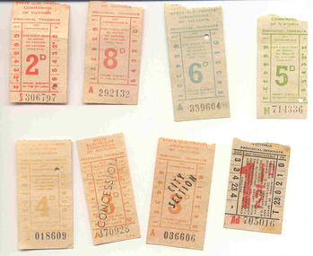
Ephemera - Ticket/s, State Electricity Commission of Victoria (SECV), Set of SEC predecimal tickets - Wal Jack Collection, 1960's
Yields information about the style and printing of tickets used in Ballarat tramways and how they were presented at the commencement of the SEC fare system. Generally issued c1963, some have dates on rear.Group of eight different pre-decimal values of used SEC Ballarat Tickets, ex the Wal Jack Collection. Tickets already held on the BTM system in blocks. All except .7, have a tartan or criss cross back. 1. - 5d Green (5 No. - B400836, B265927, W808385, B400835, Z742326) - note the same as Reg Items 3991 and 3994, though the printing of the section marks do vary a bit. These were not imaged. 2. - 5d Green (M714336) - imaged - has different section system on the side to the above - used 1/3/1963. 3. - 6d Teal - (34 No.) - some sequential - All A series. Note the same as Reg Item 3993. 4. - 6d Teal (L918047) - imaged 4009i4 - has different section system on the side to the above. 5. - 8d Red - (5 No. all A series, 292132 & 3, 206314, 315138 & 362937) - note the same as Reg Item 3984. 6. - 2d Red (S306797) - different section layout to Reg item 3986. 7. - 1 1/2d - (Ad705016) - black ticket, with red overprint of 1 1/2d fare and ticket prefix number - similar to Reg Item 2115, but different sectional layout. The section layout is the same as Reg Item 2116. Has Bushells Pty Ltd Tea advertisement on the rear. 8. - 3d City Section, Orange - (3No. A032622, 036606, 047637) - note the same as Reg Item 3982. All have dates on the rear - August 1963. 9. - 3d Concession - Orange, (A447731, 470928) - note the same as Reg Item 3989 and 4001. One has date of 1/3/63 on rear. 10 - 4d Brown (7 No. Y997727, 998446, Z004193, 005655, 012671, 018609 & 024899) - Some have dates of 1963 in pencil on the rear. Note the same as Reg Item 3995, though different series letter. All tickets and Reg Item 4006, 4007, 4010 to 4018 were received originally in a folded cloth wrapper - wax canvas? - with "All Since 1/3/1963 /3d Concession since 1/8/63" written in pencil on it. Stored with this item. See image btm4009i3. Tickets have not been formally numbered on the rear for this item No. All numbers recorded except for the 6d Teals. trams, tramways, secv, ticket -
 Ballarat Tramway Museum
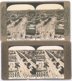
Photograph - Black & White Photograph/s, Rose Stereograph Co, c1905
Yields information about the appearance of the intersection of Sturt and Lydiard St and Sturt St itself looking west, showing the tram track arrangements.Photographic reproduction - sepia coloured of two stereo pair images with details on the sides. Originals made by the Rose Stereoscopic of Melbourne. Printed on A4 size ink-jet printer. Set of two: 1 - Sturt St and the Lydiard St intersection, electric trams looking east from the Town Hall. Shows Mount Warrenheip. Shows the roof of a tram in the bottom edge and a tram in Bridge St. Has the National Mutual building in the view, advertising the Commercial Union Fire (insurance) and Doepel and Chandler. Another building advertiser is "Carlton Ales" Image No. 8112 2 - Sturt St looking west from the Town Hall tower. Has one tram in the distance. Shows the layout of the Sturt St central median strip.trams, tramways, sturt st, lydiard st, stereo photograph, grenville st, esco, bridge st, town hall -
 Ballarat Tramway Museum
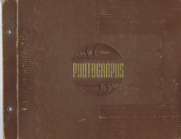
Album - Digital Photo Album, Wal Jack, "Ballarat" by Wal Jack, 1950's
Album compiled by Wal Jack of Ballarat Tram photographs. Yields information about the development of the Ballarat Tramway system through photographs, postcards, assembled by a well known Ballarat Identity - Wal Jack. Brown album marked "Photographs" on the front cover with a tooled vinyl cover, held by brass screws, containing 66 pages (including inside of covers and two blank pages) of paper (black, off white, light green, orange and brown paper) containing some 277 photographs, postcards, including some coloured postcards of Ballarat, including horse trams, ESCo and SEC trams. Each photo page has been scanned to a TIFF file with photo corners. Each photo has been scanned to a high resolution For all scans and other materials, photograph and layouts see - Collection/Archive Document Files/Reg Item 5100 including a full scan of each page and associated documentation.Individual captions for each photo.trams, tramways, ballarat, tramcars, esco, secv, wal jack