Showing 25579 items matching "plenty-township-estate"
-
 St Kilda Historical Society
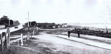
Photograph, Point Ormond Estate, c. 1915?
black and white photographMelbourne Suburbs, St Kilda. View looking south from Point Ormond Estate, Elwood -
 Greensborough Historical Society
Document, A brief history of Lower Plenty, 1830o
A brief history of the Lower Plenty area.A starting place for further investigation of the area.2 pages.lower plenty, plenty river -
 Kew Historical Society Inc
Plan - Subdivision Plan, Auburn Heights Estate, 1921
The Kew Historical Society collection includes almost 100 subdivision plans pertaining to suburbs of the City of Melbourne. Most of these are of Kew, Kew East or Studley Park, although a smaller number are plans of Camberwell, Deepdene, Balwyn and Hawthorn. It is believed that the majority of the plans were gifted to the Society by persons connected with the real estate firm - J. R. Mathers and McMillan, 136 Cotham Road, Kew. The Plans in the collection are rarely in pristine form, being working plans on which the agent would write notes and record lots sold and the prices of these. The subdivision plans are historically significant examples of the growth of urban Melbourne from the beginning of the 20th Century up until the 1980s. A number of the plans are double-sided and often include a photograph on the reverse. A number of the latter are by noted photographers such as J.E. Barnes.The name ‘Auburn Heights Estate’, was handwritten on the subdivision plan, and included 23 lots in Auburn Road and Wright and View Streets, Hawthorn. Most of the houses built on the lots that were sold still exist. The house built on number 8 View Street is a contemporary exception. The subdivision included an existing home at number 17 View Street.subdivision plans - hawthorn, auburn heights estate -
 Kiewa Valley Historical Society
Photo - Bogong Township, March 1944
In 1940 Field Headquarters for the Kiewa Scheme were established at Bogong with office, workshop facilities and accommodation for workmen, staff and some families constructed. (There had been a 'tent camp' on this site in 1939 but was destroyed by bushfires) Construction of accommodation continued until 1947. A total of 40 houses plus a hostel for single staff, post office, police station, medical centre and primary school all with water and sewerage and electricity supply. The staff hostel was known as Kiewa House and is now occupied by the Education Department. Lake Guy was named after Mr. L.T. Guy who was the Resident Engineer in charge of construction work and associated activities on the Kiewa area. He held this position from 1939 to November 1946 when he was transferred to Head Office. The Bogong Township was developed firstly as an accommodation centre (base camp) for construction workers employed under the Kiewa Hydroelectric Scheme. Due to the influx of European workers into the Township the beautification of the immediate surrounds (gardens etc.) had a distinct European flavour. This environment has been very beneficial for tourism in later years. At the completion of the scheme, in the 1960's, the village was opened to public/tourism use. Strict environmental control has not allowed for any extensive redevelopment in tourist accommodation and basically restricted it to the accommodation initially built for the construction workers. Activities such a bike riding, snow skiing, restricted horse riding and bush walking on the Alpine plains and mountains are now a viable part of the Kiewa Valley Tourist Industry. The lake is one of the many water storage reservoirs used to supply the power stations their main power to run the huge turbines generating the final product, electricityBlack and white photograph of Bogong Township taken March 1944Handwritten on the back of photo - Township March '44bogong village, secv -
 Linton and District Historical Society Inc
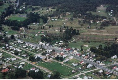
Photograph, Photographer: Alan Giles, Aerial View of Linton, 1991, 1.9.1991
Photograph taken by Alan Giles whilst on a joy flight over Linton. Shows oval, left top corner, Sussex St (Glenelg Highway) running from bottom RH corner.Colour photograph, aerial view of Linton township looking north."Linton township, Vic-1st September 1991".linton township -
Ringwood and District Historical Society
Legal record - Conditions of Sale (C.E.Carter), Ringwood - Electric Railway Estate, Crown Allotment 18, Purchasers B. Tilbury & A.Albon. 1925
Particulars and Conditions of Sale of Property , Lots 98 & 99 The Electric Railway Estate, to Bertie Tilbury & Arthur Albon -
 Whitehorse Historical Society Inc.
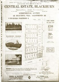
Flyer - Document, Central Estate Blackburn
Brochure advertising auction sale of 35 allotments,Brochure advertising auction sale of 35 allotments, Central Estate, Blackburn by Coghill & Haughton and F.G.Woods & Co. (2copies)Brochure advertising auction sale of 35 allotments, central estate blackburn, coghill & haughton, f.g. woods & co., oakley, thompson & davies, auctions -
 Whitehorse Historical Society Inc.
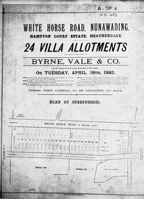
Document, Hampton Court Estate
Plan of subdivision Hampton Court EstatePlan of subdivision Hampton Court Estate Whitehorse Road, Nunawading 1882. Original in Vale Maps LaTrobe LibraryPlan of subdivision Hampton Court Estate hampton court estate, byrne vale & co. -
 Whitehorse Historical Society Inc.
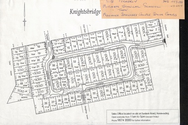
Map, Knightsbridge Estate, Nunawading, Ca 1997 - 1998
Plan of subdivision of former Mitcham Technical School and later Mullauna Secondary College Senior Campus - Knightsbridge Estate.land subdivision, knightsbridge estate, mitcham technical school, mullauna secondary college, senior campus, cherrybrook close, nunawading, knightsbridge avenue, sunnyside avenue, crest grove, dunlavin road, mitcham, carter avenue, humphreys avenue -
Whitehorse Historical Society Inc.
Document, Windsor Park Estate, 2005?
City of Whitehorse individual Heritage properties review 2006: Study of Windsor Park Estate and 32 High Street.City of Whitehorse individual Heritage properties review 2006: Study of Windsor Park Estate and 32 High Street.City of Whitehorse individual Heritage properties review 2006: Study of Windsor Park Estate and 32 High Street.windsor park estate, surrey hills, mont albert, houses -
 Whitehorse Historical Society Inc.
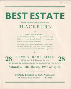
Document, Best Estate, 1/03/1957 12:00:00 AM
Auction of the Best Estate, Middleborough Road, Blackburn North, 28 home sites. Auctioneer Frank Fisher & Co.frank fisher co., best estate, blackburn north, middleborough road, blackburn -
Whitehorse Historical Society Inc.
Document, Heatherdale Estate, Mitcham, n.d
Private sale brochure for the Heatherdale Estate, Mitcham.Private sale brochure for the Heatherdale Estate, Mitcham, comprising 195 allotments. Sale agent Drake & Co., Mitcham.Private sale brochure for the Heatherdale Estate, Mitcham. heatherdale estate, mitcham, kulnine avenue, mitcham, purches street, mitcham, culwel avenue, mitcham, walwa street, mitcham, blossom street, mitcham, nymph street, mitcham, heatherdale road, mitcham, drake co. -
 Kew Historical Society Inc
Plan - Subdivision Plan, Corsewall Estate, Hawthorn, 1938
The Kew Historical Society collection includes almost 100 subdivision plans pertaining to suburbs of the City of Melbourne. Most of these are of Kew, Kew East or Studley Park, although a smaller number are plans of Camberwell, Deepdene, Balwyn and Hawthorn. It is believed that the majority of the plans were gifted to the Society by persons connected with the real estate firm - J. R. Mathers and McMillan, 136 Cotham Road, Kew. The Plans in the collection are rarely in pristine form, being working plans on which the agent would write notes and record lots sold and the prices of these. The subdivision plans are historically significant examples of the growth of urban Melbourne from the beginning of the 20th Century up until the 1980s. A number of the plans are double-sided and often include a photograph on the reverse. A number of the latter are by noted photographers such as J.E. Barnes.This is a second, more complete version of the Corsewall Estate subdivision that is held by the Society. The Coreswall Estate was a subdivision, bordering on Barkers Road and Auburn Road, which created Corsewall Close. This relatively late subdivision included 29 allotments. The subdivision plan includes the dimensions of each lot as well as the width of the existing and projected roads and turning circles. The Corsewall Close Precinct is now listed on the Victorian Heritage Database (HO147) and is noted for its ‘consistent flat-type development over the entire street, which has been cleverly designed to make multi-unit dwellings appear as single buildings’. In this second version of the plan, the rarity of this late subdivision is emphasised by the auctioneers. The original plan must have contained a photograph, which is unfortunately truncated here.subdivision plans - hawthorn, corsewall estate -
 Greensborough Historical Society
Advertising Leaflet, Buckingham & Company: Supporting the Local community, 28/07/2014
"Buckingham & Company: Supporting the Local community, proud sponsors of these organisations". This leaflet lists some of the local organisations sposored by this company. On the reverse, 7 images of homes sold by Buckinghams in 2018: 13 Alban Street Montmorency ($1,850,000), 29 Banfield Terrace Greensborough ($1,061,000), 46 Cressy Street Montmorency ($1,400,000), 46 Mountain View Road ($940,000), 2/8 Wattle Avenue Montmorency ($1,320,000), 2A Rattray Road Montmorency ($670,500) and 3 Crellin Crescent Watsonia ($9000,000).Real estate advertising leaflet, one sheet, printed in colour on one side. 7 small colour images pasted on reverse.buckingham & company real estate agents -
 Eltham District Historical Society Inc
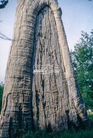
Slide - Photograph, Scar tree, Lower Plenty, c.Apr. 1993
Possibly near Bonds Road Lower Plenty35mm colour positive transparency (1 of 22) Mount - Kodak EktachromeProcess Date "Apr M"significant tree, lower plenty, scar tree -
 Eltham District Historical Society Inc
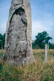
Slide - Photograph, Scar tree, Lower Plenty, c.Apr. 1993
Possibly near Bonds Road Lower Plenty35mm colour positive transparency (1 of 22) Mount - Kodak EktachromeProcess Date "Apr M"significant tree, lower plenty, scar tree -
 Greensborough Historical Society
Slide - Photograph, John Ramsdale, Near Plenty Gorge: Slide 100, 1990s
Photograph shows bushland near Plenty GorgePart of the John Ramsdale collection of slides and audio visual material.Colour photograph scanned from slide.No maker's marks. No caption on slide.plenty gorge, plenty gorge metropolitan park -
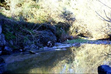 Greensborough Historical Society
Slide - Photograph, John Ramsdale, Plenty River: Slide 104, 1990s
Photograph shows a riverbank with rubbish on the Plenty River.Part of the John Ramsdale collection of slides and audio visual material.Colour photograph scanned from slide.No maker's marks. No caption on slide.plenty river, pollution -
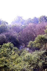
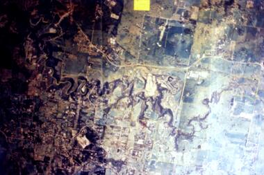 Greensborough Historical Society
Slide - Photograph, John Ramsdale, Aerial view of Plenty River: Slide 16, 1990s
Photograph shows aerial view of the Plenty River.Part of the John Ramsdale collection of slides and audio visual material.Colour photograph scanned from slide.No maker's marks. No caption on slide.plenty river, aerial photograph -
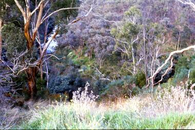 Greensborough Historical Society
Slide - Photograph, John Ramsdale, Looking down on Plenty Gorge: Slide 38, 1990s
Photograph shows a view of the bushland at Plenty Gorge.Part of the John Ramsdale collection of slides and audio visual material.Colour photograph scanned from slide.No maker's marks. No caption on slide.plenty gorge metropolitan park, plenty gorge, bushland -
 Greensborough Historical Society
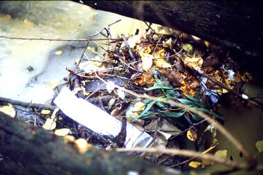
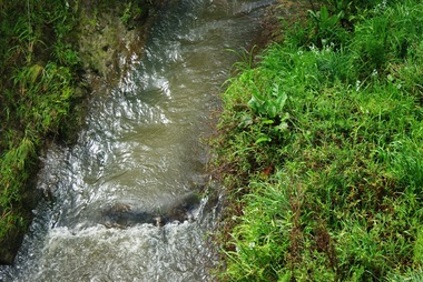
Slide - Photograph, John Ramsdale, Rubbish in Plenty River: Slide 58, 1990s
Photograph shows leaf mulch in Plenty River.Part of the John Ramsdale collection of slides and audio visual material.Colour photograph scanned from slide.No maker's marks. No caption on slide.plenty river -
 Greensborough Historical Society
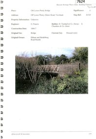
Document - Document Collection, Allom Lovell & Associates, Old Lower Plenty Bridge, 2001
Heritage citation for the Old Lower Plenty Bridge, copied from Banyule Heritage Places Study; a short history of the bridge and a news clipping, dated 2001 reporting on the re-opening of the bridge as a link in the Plenty River Trail.4 p., illus. Heritage citation, 2p.; history of bridge, 1p.; newspaper clipping, 1p. plenty river, plenty river trail, old lower plenty bridge, lower plenty -
 Eltham District Historical Society Inc
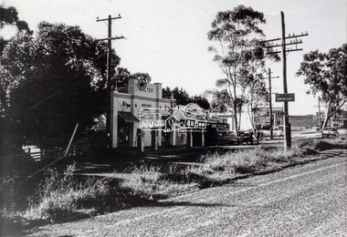
Photograph, Main Road, Lower Plenty at intersection of Old Eltham Road
View looking north across the main road towards the Lower Plenty shops showing the Lower Plenty Garage and store which was later developed into a Caltex service station, since demolished and replaced by a new Aldi supermarket.Black and white print Roll of 35mm colour negative film, 5 of 7 strips Kodak CP100 5094 and associated print Roll of 35mm black and white negative film, 3 strips Ilford FP4 and associated print Roll of 35mm colour negative film, 2 strips Kodak CP100 5094 and associated printaldi, caltex service station, lower plenty, lower plenty garage, lower plenty shops, main road, old eltham road, shops -
 Kew Historical Society Inc
Plan - Subdivision Plan, Jas R Mathers Son & McMillan, Clifton Estate, Kew, c. 1916
Pru Sanderson, in her groundbreaking ‘City of Kew Urban Conservation Study : Volume 2 - Development History’ (1988), summarised the periods of urban development and subdivisions of land in Kew. The periods that she identified included 1845-1880, 1880-1893, 1893-1921, 1921-1933, 1933-1943, and Post-War Development. These periods were selected as they represented periods of rapid growth or decline in urban development. An obvious starting point for Sanderson’s groupings involved population growth and the associated economic cycles. These cycles also highlighted urban expansion onto land that was predominantly rural, although in other cases it represented the decline and breakup of large estates. A number of the plans in the Kew Historical Society’s collection can also be found in other collections, such as those of the State Library of Victoria and the Boroondara Library Service. A number are however unique to the collection.The Kew Historical Society collection includes almost 100 subdivision plans pertaining to suburbs of the City of Melbourne. Most of these are of Kew, Kew East or Studley Park, although a smaller number are plans of Camberwell, Deepdene, Balwyn and Hawthorn. It is believed that the majority of the plans were gifted to the Society by persons connected with the real estate firm - J. R. Mathers and McMillan, 136 Cotham Road, Kew. The Plans in the collection are rarely in pristine form, being working plans on which the agent would write notes and record lots sold and the prices of these. The subdivision plans are historically significant examples of the growth of urban Melbourne from the beginning of the 20th Century up until the 1980s. A number of the plans are double-sided and often include a photograph on the reverse. A number of the latter are by noted photographers such as J.E. Barnes.The Clifton Estate was an ambitious subdivision. It included 61 allotments bordering Cotham and Park Hill Roads, and Florence and Adeney Avenues. It is difficult to ascertain the exact year when the ‘Clifton Estate’ was surveyed, subdivided and first auctioned. The uncertainty may be due to allotments being released during the First World War. The subdivision took its name from the house ‘Clifton’ (lot 5) on the corner of Adeney Avenue and Cotham Road. The outline of Clifton (since demolished) and the extent of its land following the subdivision are represented on the plan. The auctioneers have also shown ‘Maryfield’ and ‘Wimba’, the neighbouring properties in Cotham Road, on the plan."B"subdivision plans - kew, clifton estate, cotham road, adeney avenue, florence avenue, park hill road -
 City of Moorabbin Historical Society (Operating the Box Cottage Museum)
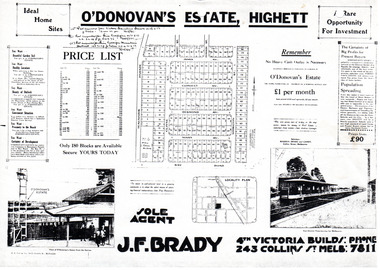
Flyer - O'Donovan's Estate, Highett
At the end of World War One, there was a renewed interest in residential land and a number of estates opened up in the Municipality of Moorabbin.Example of the progress of the Municipality of MoorabbinAdvertising flyer for auction of real estate sales - plan of building blocks for saleO'Donovan's Estate Highett - 180 blocksjames ave, clonmult ave, desmond av, mary av, bay road, cloyne street, middleton st, real estate, highett -
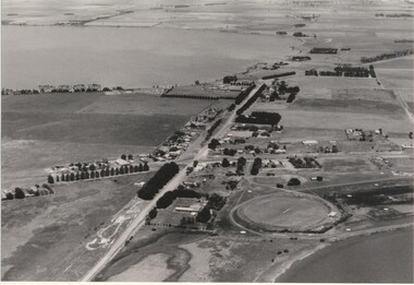 Lake Bolac & District Historical Society
Black and white photograph, Aerial view of Lake Bolac township, circa 1970
Lake Bolac township, 1970. This picture shows the 2nd football oval, tennis courts, golf course and racecourse (front-right) above the salt lake and the Lake Bolac Common (front-left). The Primary School is still on its original site between the oval and the Ararat road. The High School is beside the fresh-water lake (centre back) and to its left are the early caravan park and bowling club. The Aquatic Club shed can just be seen behind the lake bank. Photograph taken by Lewis Wills.lake bolac, football oval, tennis courts, race track, golf course, bowling club, caravan park, aquatic club shed, primary school, high school -
 Greensborough Historical Society
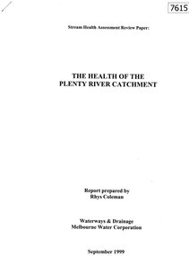
Document - Report, Rhys Coleman, The Health of the Plenty River Catchment 1999, 1999_09
Report prepared by Rhys Coleman for Waterways and Drainage, Melbourne Water Corporation, discusses the health of the Plenty River catchment from upstream of Toorourrong Reservoir, through Whittlesea and Mernda, South Morang and Plenty to Greensborough and confluence with the Yarra River.31 p., tables.plenty river, melbourne water corporation -
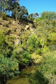 Greensborough Historical Society
Photograph - Digital Image, Plenty River Greensborough, May 2014 -10, 21/05/2014
The Plenty River flows south from Mt Disappointment before meeting with the Yarra River at Rosanna. Early settlement in Greensborough was based around the Plenty River. These images were taken in the Greensborough area by Marilyn Smith May 2014.Digital copy of colour photograph.plenty river -
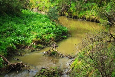 Greensborough Historical Society
Photograph - Digital Image, Plenty River Greensborough, May 2014 -9, 21/05/2014
The Plenty River flows south from Mt Disappointment before meeting with the Yarra River at Rosanna. Early settlement in Greensborough was based around the Plenty River. These images were taken in the Greensborough area by Marilyn Smith May 2014.Digital copy of colour photograph.plenty river -
 Greensborough Historical Society
Photograph - Digital Image, Plenty River Greensborough, May 2014 -8, 18/09/2014
The Plenty River flows south from Mt Disappointment before meeting with the Yarra River at Rosanna. Early settlement in Greensborough was based around the Plenty River. These images were taken in the Greensborough area by Marilyn Smith Sept 2014.Digital copy of colour photograph.plenty river