Showing 1268 items matching "recent"
-
 Kew Historical Society Inc
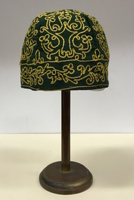
Headwear - Green Cotton & Yellow Silk Ribbon Smoker's or Lounge Cap, 1860s
The context in which the hat was made and worn assists in establishing its potential historic significance. 'Bailliere's Victorian Gazetteer and Road Guide containing the most recent and accurate information as to every place in the Colony' (1870), describes the village of Vaughan as being located on the road from Daylesford to Castlemaine. In 1870 the Vaughan was deemed to be entirely a gold mining area, gold having been discovered in the district in 1853. Intriguingly the entry in the Gazetteer claims that the electoral division of Vaughan began at the junction of the Middleton Creek and the Loddon River, so perhaps the cap might have belonged to a member of a significant local family. In 1870, Vaughan had a population of about 1000 persons and included almost 300 dwellings. Articles from newspapers, published on Trove refer frequently to a Mr Middleton as a litigant in court cases before the Vaughan Court in the 1860s. By the 1870s, the Mt Alexander Mail, in an article on ‘Mining: The Pioneer Wheel’ describes the success of Mr Middleton and his Middleton’s Reef Gold Quartz Mining Company, which had built the largest water wheel in the Colony. The wheel was 20’ in diameter and 2’ wide. Quartz mining as practiced by companies such as Middleton’s had become necessary after the exhaustion of alluvial quartz mining deposits in the 1860s. So we can probably establish a link between the cap and a significant mining identity in the period in which the article was made. The historical significance of the cap is only one part of the story. Caps such as the Middleton example can also be items of aesthetic significance as they were typically, examples of women’s work, using published patterns in magazines such as the Ladies Home Magazine. While women might follow or adapt a published pattern, their choice of materials reflected what was available locally. The fine hand stitching on this example is evidence of high quality domestic needlework. The maker crafted the cap from five triangular pieces of cotton cloth, each piece lined with a faded yellow net. The net provides some stiffening for the cap and has a functional purpose in that it anchors the hand-stitched, looped design of yellow silk ribbon that decorates the surface of the cap. Gentleman’s smoking (lounging) cap believed to have been made in c.1860-69. The conical hat is made of a dark green cotton fabric embroidered with narrow ribbon of a paler green silk. The unlined rimless hat is made of four pieces of fabric. There is no evidence of the hat at one stage featuring a tassle. The original donation record noted that the cap had been made for, and was worn by, a Mr Middleton, of Vaughan in Central Victoria. Nilhats, smokers hats, men's clothing -
 Wodonga & District Historical Society Inc
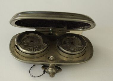
Decorative object - Fob sovereign Holder
The first British gold sovereign was minted as long ago as 1489 under the reign of Henry VII. Subsequent monarchs issued their own gold coins until the reign of James I, crowned King of England and Scotland in 1603 when the practice died out. The modern use of the sovereign and half sovereign coins as common currency in Britain began in 1817. In Australia, the Sydney Mint was established as a branch of the Royal Mint in London in 1855. Its primary role, together with the mints of Melbourne (1872-1931) and Perth (1899-1931) was to strike Sovereigns and Half Sovereigns from the gold that had been discovered in the goldfields of Victoria and New South Wales in 1851. During the First World War, the Sovereign - like most gold and silver coins - was gradually withdrawn from general circulation, although special limited issue coins have frequently been minted for special events, such as the Platinum Jubilee and recent death of Queen Elizabeth 11. Sovereign cases were small portable boxes usually in cylindrical shape and made from various metals with snapshut covers to contain the coin. The spring in the base allowed several coins to be stored in a small container. These fob holders were particularly common in the late 19th to early 20th century and were frequently used by men who could then safely carry coins in their suit pockets. This case was used by a member of the Raper family of Wodonga, Victoria. This item is from the Raper Collection donated to the Wodonga Historical Society by Mrs. Jean Raper.A small silver case with a fob attachment designed to hold sovereign and half sovereign coins. Inside the case are 2 circular spring loaded receptacles to hold the coins. The lid is lined with velvet. A clip and fob is attached to the front of the case.currency, predecimal coins -
 Wooragee Landcare Group
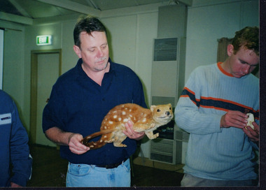
Photograph, 28th April 2004
Wooragee Landcare was formed in 1989 to promote sustainable conservation and land-use practices in the North-East region of Victoria. The organisation's work has included public awareness and education campaigns to control invasive, introduced species and protect native wildlife, such as campaigns to bait or trap foxes and to identify and monitor quoll populations in the region. The organisation has drawn on the work of a variety of Government and academic experts to inform best practice approaches are utilised. In 2004 Andrew Murray, a leading quoll expert from Parks Victoria, conducted training for Wooragee Landcare members and the local community in how to identify potential quoll habitat and populations (through identifying scat and other methods). Spotted-tail or Tiger quolls were known to have lived in the Mt Pilot and Stanley Plateau region previously but habitat encroachment, competitor species such as foxes and natural disasters had reduced sightings in recent years. The Spotted-Tail quoll (formerly known as the Tiger Quoll) is the largest of four species of native marsupial carnivore on mainland Australia, and the second-largest carnivore (after the dingo). The species' scientific name, Dasyurus maculatus, references its' 'hairy tail'. Adults are approximately 125cm long, including their long tail, and weigh around 5 kilograms. The Spotted-tail quoll is currently considered to be a threatened species, but other species are currently listed as endangered.This photograph is significant as an example of wildlife protection awareness programs undertaken by Wooragee Landcare Group in the 2000s in Indigo Shire.Landscape coloured photograph printed on gloss paper.Reverse: WAN NA 0ANA2N0 NNN+ 1 8743 / [PRINTED] (No.23) / 269wooragee, wooragee landcare, indigo shire, north-east victoria, andrew murray, queries about quolls, wildlife, conservation, farming, predators, spotted tail quolls, quolls, marsupials, south-east forests, mt pilot, stanley plateau -
 Flagstaff Hill Maritime Museum and Village
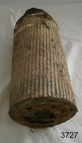
Weapon - Ammunition Shell, late 19th-early 20th century
Ammunition shell was used in a 40 lb Armstrong Rifled Breach Loading (RBL) Gun. The shell was fired into Westernport Bay by the Hastings Battery Field Artillery in late 1800’s or early 1900’s. It was recovered by divers in recent times. It does not contain explosives because the projectile and explosive were separate items. The Armstrong 40 lb BL Gun There were 4 x 40lb Armstrong (RBL) Guns issued to the Ham and Beef Battery at Hastings Victoria. After the Hastings Battery field artillery disbanded, the 4 Guns were transferred from the Hastings Battery to the Warrnambool Battery field artillery in 1904. (There is a photograph of one of these guns on its carriage, pictured in front of the Orderly room (Drill Hall) at Warrnambool, which is now the Library of South West TAFE). The 40lb Armstrong Guns were recalled back to Melbourne when the government issued the updated 4.7inch QF (Quick Firing) Naval Guns, mounted on carriages, to the Warrnambool Garrison Artillery 1907. The Hastings Museum today holds one of the original 40lb Armstrong RBL guns that were at first at Hastings and then Warrnambool, evidenced by tracing the numbers on that gun. This gun has now been restored. Surviving 40 lb Armstrong BL Guns in Australia The Hastings Museum has restored one of the Guns that was at Hastings and then from 1904-1907 in Warrnambool. This Gun is now on display at the Hastings Museum. This ammunition shell from a 40lb Armstrong RBL gun is very significant because of its association with the Warrnambool Battery Field Artillery in the early 1904-1907. It is known that the original 40lb Armstrong RBL gun used in Warrnambool is now restored and on display at the Hastings Museum. Ammunition shell from a 40Ib Armstrong Rifled Breach loading (RBL) Gun. Metal bullet-shaped object, flat base, tapering to cone-shaped tip. Parallel equidistant ridges run from outer edge of base to position where cone shape begins. Tip has a square-shaped hole in the centre and has a very uneven surface. Base has corrosion and metal is flaking away. Does not contain explosives. Remnants of white paint-like substance in several places. From the Hastings, Victoria, area. Late 19th - early 20th century.flagstaff hill, warrnambool, shipwrecked coast, flagstaff hill maritime museum, maritime museum, shipwreck coast, flagstaff hill maritime village, great ocean road, ammunition shell, 40 lb armstrong rbl gun, volunteer corps, war equipment, defence forces, warrnambool bettery field artillery, hastings battery field artillery, defence of warrnambool -
 Glen Eira Historical Society
Article - Princes Park
This file contains four items. Princes Park information kit (misspelled princess park) compilation (clipped together) of photocopied material about aspects of the park, beginning with Princes Park North East Ground, official report for Glen Eira Council on condition of the park and recommendations for improvements, with blueprints and maps of proposed development. No date but most recent dated page (two letters from Douglas R Aylen, Chief Executive Officer, City of Caulfield, to residents about Princes Park playground is dated 20/05/1991. Includes photocopies of official materials on the purchase of land for the Park beginning in 1920. About sixty pages in all of which several relate to Caulfield Football Club and its campaign for a new pavilion 1967-70. Community News featuring Caulfields Parks and Gardens cutting from Caulfield Contact, 12/1991, on improvements to the park. Photocopy of letter from Rohan Storey Campaigns Coordinator, National Trust of Australia, Victoria to Manager, Planning Section, Glen Eira Council, dated 13/09/2002, headed National Trust Classification of Tree at Princes Park, South Caulfield Quercus suber (cork oak) at Regional level. Includes attached assessment form. Two black and white photocopies of photographs of Princes Park undated from Glen Eira Library Princes Park file, handwritten verso.princes park, parks and resources, glen eira city council, wilson k.d, harris mr, bricker d.c, caulfield football club, victorian football association, princes park trust, evans tim, ladson w.t, dixon r.c, caulfield church of christ, lewis mrs. i.e, caulfield south bowling club, hawkins a.w, briggs j.a, mcdonald s.l, renouf l.s, patience geoff, little ajax football club, gardenvale football club, south east suburban football club, southern metropolitan police football club, caulfield city soccer club, christian brother old boys, caulfield bears cricket club, national trust of australia (victoria), cork oak, tree, storey rohan -
 Wooragee Landcare Group
Photograph, 28th April 2004
Wooragee Landcare was formed in 1989 to promote sustainable conservation and land-use practices in the North-East region of Victoria. The organisation's work has included public awareness and education campaigns to control invasive, introduced species and protect native wildlife, such as campaigns to bait or trap foxes and to identify and monitor quoll populations in the region. The organisation has drawn on the work of a variety of Government and academic experts to inform best practice approaches are utilised. In 2004 Andrew Murray, a leading quoll expert from Parks Victoria, conducted training for Wooragee Landcare members and the local community in how to identify potential quoll habitat and populations (through identifying scat and other methods). Spotted-tail or Tiger quolls were known to have lived in the Mt Pilot and Stanley Plateau region previously but habitat encroachment, competitor species such as foxes and natural disasters had reduced sightings in recent years. The Spotted-Tail quoll (formerly known as the Tiger Quoll) is the largest of four species of native marsupial carnivore on mainland Australia, and the second-largest carnivore (after the dingo). The species' scientific name, Dasyurus maculatus, references its' 'hairy tail'. Adults are approximately 125cm long, including their long tail, and weigh around 5 kilograms. The Spotted-tail quoll is currently considered to be a threatened species, but other species are currently listed as endangered. This photograph is significant as an example of wildlife protection awareness programs undertaken by Wooragee Landcare Group in the 2000s in Indigo Shire.Landscape coloured photograph printed on gloss paper.Reverse: WAN NA 0ANA2N0 NNN+ 2 8743 / [PRINTED] (No.22) / 268wooragee, wooragee landcare, kiewa landcare, indigo shire, north-east victoria, farming, conservation, wildlife, quoll, quolls, marsupials, predators, simon feillafe, andy murray, south-east forests, spotted tail quoll, mt pilot, stanley plateau, andrew murray -
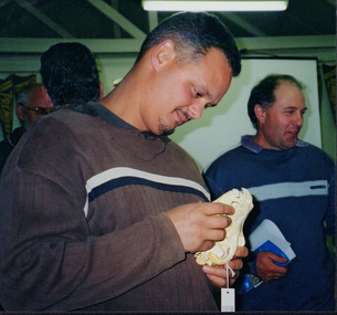
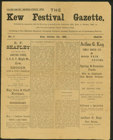 Kew Historical Society Inc
Newspaper, Kew Festival Gazette, No.1, October 5th 1895, 1895
The first known use of the term 'Kew Festival'.The Kew Festival Gazette, 5 October 1895 is a four-page mock-up newspaper, published from the Boroondara Standard office to advertise and publicise a Kew Festival. The Festival was not associated with the current Kew Festival, which was founded in 1974, but was principally a bazaar held in the Kew Recreation Hall to raise money for the Kew Catholic Church Building Fund which was associated with the Jesuit Mission. Perhaps because of the recent economic depression, the Mission was in financial difficulties and it was hoped that the bazaar would raise enough money to ease the situation. According to the Gazette, ‘All Kew has been in a gentle simmer of excitement for some time past over the coming Sacred Heart Bazaar in aid of the Jesuit Mission funds. Wherever one goes the talk is of the bazaar, and whoever one meets is either a stallholder, an assistant or an intending purchaser.’ There are a few items in the Gazette about other local events, including a cake fair and sale of works, and a history of bazaars that traces them from the Middle East via Britain to Kew. One article contains some examples of nineteenth century humour, including ‘the lady stallholders will not have to pay income tax on their takings’. The advertisements reflect the goods and services available to Kew residents in 1895 – groceries, wine & spirits, hay, corn, chaff, ironmongery, timber, drapery, millinery, gas cookers, and an undertaker and embalmer. kew festival gazette, kew catholic church, boroondara standard -
 Bendigo Historical Society Inc.
Map - Laminated map of Lake Eppalock at full capacity. Map 'E'
John Perry Collection. Laminated map of Lake Eppalock at full capacity. Black and white. The dam was built by the State Rivers and Water Supply Commission of Victoria. The dam wall height is 45 metres (148 ft) and the main embankment is 1,041 metres (3,415 ft) long. At 100% capacity the dam wall was designed to hold back 304,651 megalitres (6.7014×10¹⁰ imp gal; 8.0480×10¹⁰ US gal) of water. The surface area of Lake Eppalock is 3,011 hectares (7,440 acres) and the catchment area is 2,124 square kilometres (820 sq mi). The controlled spillway is capable of discharging 8,040 cubic metres per second (284,000 cu ft/s). Lake Eppalock supplies both stock and domestic water to the Campaspe irrigation district. It also serves as a water supply to Bendigo and Heathcote and, in more recent times, Ballarat. The lake is a major attraction for those engaging in watersports, with a number of tourist parks and accommodation facilities available. Permissible activities on the lake include high-speed boating, water skiing, sailing, canoeing, fishing and swimming. The lake's water levels were low for approximately eight years between 2002 and 2010 during a prolonged drought, which restricted the amount of recreational activity until rainfall in the latter half of 2010 returned the lake to 100 percent capacity. Built between 1961 and 1964, Lake Eppalock remains the only water storage on the Campaspe River system.map, eppalock, water, dam, reservoir -
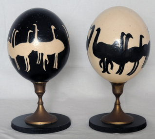 Orbost & District Historical Society
eggs
These eggs could be ostrich eggs from an ostrich farm which operated just out of Marlo. It is likely that they were donated by Kate and Richard Earle who ran the enterprise. Emu and ostrich eggs are perfect for decorating, painting or carving. Emu egg shells have multiple layers ranging from an inner white layer through to the dark green outer layer. The contents must be removed through a small hole (either tool drilled or poked with a needle). After the yolk has been blown out (scrambling the yolk first by poking with a needle will make it easier to remove), the egg needs to be washed through and left to drain dry. It can then be painted, carved, etched or decorated. Emu decorating is a traditional Aboriginal art. The carving of emu eggs by Indigenous and non-Indigenous people was popular in the late 19th century but production declined in the 20th century, partly due to the protection of eggs through legislation. This has been overturned in recent years with the development of commercial emu farms. In the period between the two world wars particularly, with the production of other Aboriginal artefacts for an outside market, the carving of emu eggs provided an important source of income for Aboriginal people in many parts of Australia. It was a widespread practice in the south-east and it was not unusual for Aboriginal people to decorate their own homes with carved eggs and other items created by themselves or community members, serving to affirm an Indigenous identity within the domestic environment. (ref National Gallery of Australia)This item is significant for its uniqueness and aesthetic appeal.Two painted eggs on stands. 1907.1 is painted black and has white emus or ostriches painted on it. 1907.2 is painted white and has black emus or ostriches painted on it. Both stands are wooden with brass pedestals. The eggs are possibly ostrich eggs.handcraft emu-egg ornament ostrich-egg -
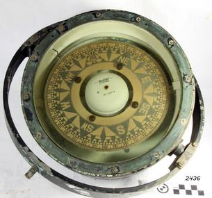 Flagstaff Hill Maritime Museum and Village
Compass, 1940's
Henry Browne and Son Ltd, of Barking, made aviation and nautical compasses, clocks and dials. The company made compasses for aircraft notably, Spitfires, Tiger moths and Concord. Henry Browne was born in Lewis, Sussex in 1842 and died in Barking in 1935. His company was a well respected English instrument maker that had been making and selling fine quality compasses, ship's clocks, inclinometers, sextants, and chandlery items for over 140 years. It started in a factory in Brightlingsea, Essex and moved to Barking in 1929. The Trade Mark brand Sestrel was used on all their equipment. Their “Dead Beat“ compass design is well dampened serving to reduce oscillations. It is reported that this design compass was fitted to many Allied ships during WW II. The company went through a boom period in the 1970s but collapsed in the 1980s due to the popularity of cheaper plastic compasses over tradition brass ones. Over more recent years, there has been a consolidation of British instrument makers and the firm of Henry Browne & Son has changed hands a number of times. At last count, it became part of Lillie & Gillie of London in 1985 when John Lilley & Gillie Ltd acquires the assets of Henry Browne & Sons (Sestrel) Ltd, a major competitor for what may be the second time. The model name of Sestral came about via the following.Take first two letters of the word Sensitive then the firs two letter of steady and the firs three letters of reliable hence the trade name of "Sestral". Item relates to the second world war used in many ships of the time merchant and military, It reminds us of a time in our social and world history when most of the world was in conflict.Henry Browne and Sons “Dead Beat“ compass design is well dampened serving to reduce oscillations and was an innervation that many makes of compass of the time din't have as a result the "Sestrel" design was fitted to many Allied ships during WW II.A liquid-filled Sestrel compass, with a brass housing and gimbal ring, wired for an internal low voltage light to illuminate the compass card. Inscriptions printed on face and impressed in metal around outer rim TRADE MARK", "Sestrel Dead-Beat", "No 1724 N", "Barking & London" HENRY BROWNE & SON", additional inscription "AFT No 1724 N". flagstaff hill, warrnambool, shipwrecked-coast, flagstaff-hill, flagstaff-hill-maritime-museum, maritime-museum, shipwreck-coast, flagstaff-hill-maritime-village, compass, marine compass, henry browne & son barking london, sestrel dead-beat marine compass, navigation instrument, sestrel dead-beat marine compass -
 Federation University Historical Collection
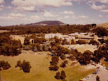
Photograph - Photograph - Colour, VIOSH: Early photograph of the Mount Helen Campus - Ballarat Institute/College of Advanced Education
Victorian Institute of Occupational Safety and Health (VIOSH) Australia is the Asia-Pacific centre for teaching and research in occupational health and safety (OHS) and is known as one of Australia's leaders on the field. VIOSH has a global reputation for its innovative approach within the field of OHS management. VIOSH had its first intake of students in 1979. At that time the Institution was known as the Ballarat College of Advanced Education. In 1990 it became known as Ballarat University College, then in 1994 as University of Ballarat. It was 2014 that it became Federation University. VIOSH Australia students are safety managers, senior advisors and experienced OHS professionals. They come from all over Australia and industry. Students are taught active research and enquiry; rather than textbook learning and a one-size fits all approach. VIOSH accepts people into the Graduate Diploma of Occupational Hazard Management who have no undergraduate degree - on the basis of extensive work experience and knowledge. In 1964 the Victorian Government announced that a committee be established to plan for the establishment of a Victorian Institute of Colleges. Eight Technical colleges would be raised to the level of university colleges. Ballarat School of Mines was on the list. Plans were also underway for the development of a new campus at Mount Helen. The Mount Helen Campus was officially opened on 30 October 1970 by the Hon Sir Nigel Bowen, Minister for Education and Science. It was at this Campus, in 1977, that VIOSH was conceived and from 1979, when the first intake of VIOSH students started, it became a significant course at Ballarat College of Advanced Education and continued to recent times.Colour photograph showing the Mount Helen Campus buildings.viosh, victorian institute of occupational safety and health, victorian institute of colleges, ballarat school of mines, university colleges, hon sir nigel bowen, minister for education and science, mount helen campus, ballarat college of advanced education -
 Flagstaff Hill Maritime Museum and Village
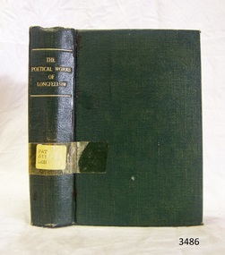
Book, William P. Nimmo, The Poetical Works of Henry Wadsworth Longfellow, (short title on cover is ‘The Poetical Works of Longfellow’), n.d.!
As mentioned in the Description, the cover of The Poetical Works of Henry Wadsworth Longfellow is plain and in good condition. The internal pages are in similarly good condition, straight cut, and secured to the book binding with no signs of heavy use or wear. However the paper of the internal pages appears yellowed with age, unlike the cover pages that join the boards to the content pages. As also noted in the Description, the internal pages have intricate lettering, with black page borders, double column printing, and nineteenth-century styled black and white illustrations (etchings). This suggests that the bound pages represent an earlier print run and the cover was added, or replaced, at a later date. The book cover’s plain green design with minimal gold lettering seems more recent publishing practice than the pages within. This book bears no publishing date, which supports the speculation that the content pages were purchased as a remaindered lot and bound and distributed by another party, possibly in Australia rather than Britain, and at a much later date than the old fashioned page formatting suggest. The good condition of the cover and the bound pages indicate the book was seldom borrowed or read and the book may therefore have been acquired after the height of the poet Longfellow’s popularity (in the mid to late nineteenth century). The stamps and labels attached to the cover and title pages testify to the book’s provenance, from its initial ownership by the Warrnambool Mechanics Institute Library, to custody in the Warrnambool Municipal Library (where it, along with other WMIL texts, was catalogued by a librarian called Pattison), and finally to the Flagstaff Hill Historical Book Collection. The book was part of a collection of books, now known as the Pattison Collection, which originally belonged to the Warrnambool Mechanics Institute Library. In this context it is an example of the range of titles carried by Victorian rural libraries in the colonial and federation periods (Significance Assessment 2009).The book is bound in plain green cloth covered board with gold lettering on the top of the spine, which reads “THE POETICAL WORKS OF LONGFELLOW”. The cover is plain otherwise and in good condition. Clear Tape secures a typed paper sticker on the lower middle of the spine, which reads “PAT 811 LON”. The internal pages are in similarly good condition, straight cut, and secured to the book binding with no signs of heavy use or wear. However the paper of the internal pages appears yellowed with age, unlike the cover pages that join the boards to the content pages. The internal pages contain intricate lettering, black page borders, double column printing, and nineteenth-century styled black and white illustrations. Name: The Poetical Works of Henry Wadsworth Longfellow Author: H W Longfellow Publisher: William P Nimmo The cover page bears a printed label stuck over an earlier one, which reads “Corangamite Regional Library Service • Warrnambool City Library • Pattison Collection”. The title page bears a flat oval shaped black ink stamp containing the words “MECHANICS WARRNAMBOOL INSTITUTE”. On this page there is also the notations “P/W 4885” written in pencil, and “821” written in blue ‘biro’.flagstaff hill, warrnambool, shipwrecked coast, flagstaff hill maritime museum, maritime museum, shipwreck coast, flagstaff hill maritime village, great ocean road, poetry, henry wadsworth longfellow, classic book, 19th century, literature, leisure, warrnambool mechanics institute library, pattison collection, henry wadsworth longfellow’s poetical works, edinburgh publisher william p. nimmo, h w longfellow, the poetical works of henry wadsworth longfellow, warrnambool public library -
 Puffing Billy Railway
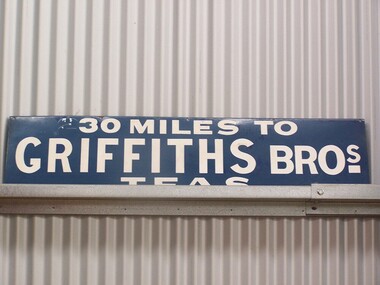
Sign - Advertising - Griffiths Tea Sign - 30 Miles, between 1879 - 1930's
In 1879, James Griffiths established one of Australia’s first tea and coffee distribution companies at 30 Flinders St, Melbourne, which is now, occupied by the boutique Lindrum Hotel. Established with his brother John, recent immigrants from England, Griffiths occupied the highest position in the commercial world during their many years as distributors of tea, coffee, cocoa and other products throughout Victoria and Australia. The Griffiths brand was a guarantee for quality of product and service as it still is today. This extensive service was provided to customers via horse drawn carts serviced by rail from Melbourne. As a spirited entrepreneur, Griffiths made his company a household name through his pioneering use of outdoor advertising by installing the infamous blue and white enamel “Griffiths Tea” promotional signs affixed to the railway boundary fences highlighting to travellers the distance to or from Melbourne, indicating so many “— miles to Griffiths Tea”. These signs, much sought after today, were well known through out the eastern states. Photographs have been published of a sign erected by a Digger in France during the First World War with the words “1100 miles to Griffiths Bros”. Tragically, James and his wife Emily with friends died in a level rail crossing accident at Bayswater in 1925. Despite this unfortunate accident, Griffiths and its culture of innovation has survived as one of the few 100% Australian owned coffee roasters, with only three owners in 128 years. http://www.griffithscoffee.com.au/about-us/back-to-1879/ Sign - Advertising - Griffiths Tea Sign - 30 MilesHistoric - Sign - Advertising - Griffiths Tea Sign - used along side of Victorian Railway lines and at StationsSign - Advertising - Griffiths Tea Sign - 30 Miles Griffiths Tea sign made of Enamel paint on metal sign30 Miles to Griffiths Tea Sign puffing billy, sign - advertising - griffiths tea sign - 30 miles -
 Whitehorse Historical Society Inc.
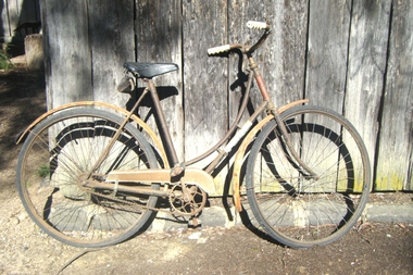
Vehicle - Bicycle
In 1914, Mr and Mrs Arthur Hooke gave the name ‘Wandinong’ to their newly purchased property in Blackburn. The name was inspired by a recent cycling trip to Wandin in the foothills of the Dandenongs, as well as the title of a favourite book, Ethel Turner’s ‘The Camp at Wandinong’. Their property and the surrounding district had originally been owned by a series of property investors and speculators, and while some of it had been cleared for grazing, most of it was still covered in virgin bush; thickly covered with trees and undergrowth and rich in wild flowers and bird life. A small section of the Hooke’s property was cleared sufficiently to r\erect a house and some outbuildings, but the rest was left as n nature intended. Mar Arthur Hooke was a local property valuer but never owned a car, preferring to attend to business on his bicycle. He was still riding his bicycle in his eighties. Meanwhile, Mrs Hooke had developed a keen desire that the ‘Wandinong’ property remain intact; that it should ultimately be set aside as a place of refuge where like-minded people could go to enjoy peace and quiet amongst the native birds and bushland.|To this end, Mr and Mrs Hooke liaised with the Nunawading Council and an agreement was reached whereby the council would assume ownership of the property on their deaths. When Mr Hooke died in 1972, his wife transferred the land over to the council the following year. Mr and Mrs Arthur Hooke’s Grandson, William, and granddaughter, Christine, recently donated their grandmother’s bicycle to the Whitehorse Historical Society. They recall that their grandfather’s bicycle was given to a representative of the Nunawading Council for safekeeping some years ago. Ladies two wheel bicycle with tool bag attached & black leather seat. Two mud guards, a skirt guard & a reflector on the back mud guard. 'Kew Flyer' painted on front mud guard. Two rubber tyres & provision for a head light on the handle bars.'Kew Flyer'transport, bicycles -
 Federation University Art Collection
Mixed media, Carole Wilson, 'Heart Mat' by Carole Wilson, 2001
Carole WILSON (1960- ) Born Canberra, Australia Carole Wilson is an artist living and working in Ballarat, Victoria where she is Associate Professor in Visual Arts and Deputy Dean in the School of Arts. Carole studied at both the Canberra School of Art and Philip Institute of Technology, now RMIT, in Melbourne and completed a PhD at the University of Ballarat in 2001. Her original training was in printmaking and she was a founding member of Jillposters, feminist poster group, in 1983 and worked at Another Planet Posters, Melbourne. For over a decade Carole Wilson has utilised discarded and salvaged materials such as floral carpets, maps and atlases to create works which engage with aspects of botany, garden history, travel and historical ornament. In recent years she has undertaken residencies in Italy, the US, Malaysia and The Netherlands which have all had a significant impact on her work. 'Woven Mantra: A Visual Expression of Meditation' is the title of Carole Wilson's thesis undertaken for a PhD - Visual Arts at the University of Ballarat in 2001. The research project examines the links between spiritual practice and visual art. More specifically, the research examines the relationships between repetition of a manta, and repetition of an image. 2010- Senior Lecturer in Visual Arts, Honours and Research Degrees Co-ordinator 2009-2011 Lecturer in Studio Practice and Postgraduate Co-ordinator 1999-2008 Lecturer in Visual Arts (Sessional) This item is part of the Federation University Art Collection. The Art Collection features over 2000 works and was listed as a 'Ballarat Treasure' in 2007.Framed artwork by Carole Wilson.art, artwork, carole wilson, wilson, university of ballarat, doctorate, arts academy, mixed media, monoprint, haberdashery -
Federation University Art Collection
Laser Print, 'Paper Shawl' by Carole Wilson
Carole WILSON (1960- ) Born Canberra, Australia Carole Wilson is an artist living and working in Ballarat, Victoria where she is Associate Professor in Visual Arts and Deputy Dean in the School of Arts. Carole studied at both the Canberra School of Art and Philip Institute of Technology, now RMIT, in Melbourne and completed a PhD at the University of Ballarat in 2001. Her original training was in printmaking and she was a founding member of Jillposters, feminist poster group, in 1983 and worked at Another Planet Posters, Melbourne. For over a decade Carole Wilson has utilised discarded and salvaged materials such as floral carpets, maps and atlases to create works which engage with aspects of botany, garden history, travel and historical ornament. In recent years she has undertaken residencies in Italy, the US, Malaysia and The Netherlands which have all had a significant impact on her work. 'Woven Mantra: A Visual Expression of Meditation' is the title of Carole Wilson's thesis undertaken for a PhD - Visual Arts at the University of Ballarat in 2001. The research project examines the links between spiritual practice and visual art. More specifically, the research examines the relationships between repetition of a manta, and repetition of an image. This item is part of the Federation University Art Collection. The Art Collection features over 2000 works and was listed as a 'Ballarat Treasure' in 2007. Carole Wilson lectures at Federation University Australia: 2010- Senior Lecturer in Visual Arts, Honours and Research Degrees Co-ordinator 2009-2011 Lecturer in Studio Practice and Postgraduate Co-ordinator 1999-2008 Lecturer in Visual Arts (Sessional) art, artwork, carole wilson, alumni -
Federation University Art Collection
Laser Print, 'Kali's Star with Orange Crosses' by Carole Wilson
Carole WILSON (1960- ) Born Canberra, Australia Carole Wilson is an artist living and working in Ballarat, Victoria where she is Associate Professor in Visual Arts and Deputy Dean in the School of Arts. Carole studied at both the Canberra School of Art and Philip Institute of Technology, now RMIT, in Melbourne and completed a PhD at the University of Ballarat in 2001. Her original training was in printmaking and she was a founding member of Jillposters, feminist poster group, in 1983 and worked at Another Planet Posters, Melbourne. For over a decade Carole Wilson has utilised discarded and salvaged materials such as floral carpets, maps and atlases to create works which engage with aspects of botany, garden history, travel and historical ornament. In recent years she has undertaken residencies in Italy, the US, Malaysia and The Netherlands which have all had a significant impact on her work. 'Woven Mantra: A Visual Expression of Meditation' is the title of Carole Wilson's thesis undertaken for a PhD - Visual Arts at the University of Ballarat in 2001. The research project examines the links between spiritual practice and visual art. More specifically, the research examines the relationships between repetition of a manta, and repetition of an image. This item is part of the Federation University Art Collection. The Art Collection features over 2000 works and was listed as a 'Ballarat Treasure' in 2007. Carole Wilson lectures at Federation University Australia: 2010- Senior Lecturer in Visual Arts, Honours and Research Degrees Co-ordinator 2009-2011 Lecturer in Studio Practice and Postgraduate Co-ordinator 1999-2008 Lecturer in Visual Arts (Sessional) art, artwork, carole wilson, printmaking, alumni -
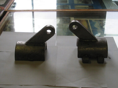 Parks Victoria - Gabo Island Lightstation
Brackets
Stainless steel brackets off the wreck of the Gypsy Moth V, wrecked near the lighthouse on 19 December 1982. These brackets were used to hold wire stays to the mast or bowsprit. The comparatively recent relics have a reliable provenance to the yacht Gipsy Moth V, which ran ashore on rocks under the lighthouse on 18 December 1982. It was the yacht that carried Sir Francis Chichester (1901-1972) on his second world voyage in 1971. While sailing the 19m (63.5ft) vessel in the 1972 Transatlantic Race, Chichester became weakened by cancer and had to abandon the competition and died two months later. His son Giles sailed the yacht back to England. In December 1982 British skipper, Desmond Hampton chartered the yacht for the around the world, single handed race. He had been running second and was nearing the end of the second leg of the competition from Cape Town, South Africa to Sydney when the accident happened. After going to bed he set the yacht on self steering and it wedged itself into a crevice just below the lighthouse and broke up. Everything was salvaged except for the masts and the engine. Twenty five years later, in 2007, items salvaged from the wreck surfaced in regional Victoria in a display of the ‘Gipsy Moth V Collection’, which included wreckage as well as photographs. The information from the ‘Sail World’ website did not provide any further details about the exhibition or its organisers.Two similar stainless steel brackets; half tubes with diagonally protruding flat section with hole at end. End is rounded. -
 Bendigo Historical Society Inc.
Document - MERLE HALL COLLECTION: ''COMMUNITY ARTS CENTRE DEPUTATION NOTES''
On front cover is: ''Community Arts Centre - Deputation Notes''. Within this stapled collection are the following: typed notes for presentation at a Public Meeting at Bendigo Municipal Offices (25/6/1975) re the ''establishment of a cultural centre in Bendigo''.J. Cannon with the names of six supportive speakers; handwritten Notes from Public Meeting 25th June 1975 (two pages); handwritten ''Notes from Public Meeting 36 June 75'' (meeting to hear address from Federal Department of Tourism and Recreation (with newspaper advertisements of meeting); Loddon Campaspe Regional Council for Social Development Interim Committee questionnaire for seminar on nine aspects - housing, educational facilities, medical and welfare services, municipal and other public services, transport and communication, conservation features, active and passive recreation, employment, shopping; handwritten notes for Public Meeting 25th June ; handwritten notes re the Plaza theatre being up for sale, letter to The Editor re the recent reported announcement by the City Council of its intention to seek Federal finance to assist in the purchase of the Plaze theatre; two-paged document (letter??) re the problems of keeping the Plaza theatre and, instead, promoting a ''fine modern facility'' of the Bendigo Arts Council (no named author); ; handwritten notes of Sub-committee - Arts Centre Building (Report - J. Cannon); handwritten notes from the ''Tours Officer'' for comments on the past year's activities; handwritten list of 30-40 local people with 'ticks'' for their (potential) interest and time?? -
 Bendigo Historical Society Inc.
Map - Laminated map of Lake Eppalock at full capacity
John Perry Collection. Laminated copy of map of Lake Eppalock at full capacity. Had highlighter markings of old roads which appear to be still in use. The dam was built by the State Rivers and Water Supply Commission of Victoria. The dam wall height is 45 metres (148 ft) and the main embankment is 1,041 metres (3,415 ft) long. At 100% capacity the dam wall was designed to hold back 304,651 megalitres (6.7014×10¹⁰ imp gal; 8.0480×10¹⁰ US gal) of water. The surface area of Lake Eppalock is 3,011 hectares (7,440 acres) and the catchment area is 2,124 square kilometres (820 sq mi). The controlled spillway is capable of discharging 8,040 cubic metres per second (284,000 cu ft/s). Lake Eppalock supplies both stock and domestic water to the Campaspe irrigation district. It also serves as a water supply to Bendigo and Heathcote and, in more recent times, Ballarat. The lake is a major attraction for those engaging in watersports, with a number of tourist parks and accommodation facilities available. Permissible activities on the lake include high-speed boating, water skiing, sailing, canoeing, fishing and swimming. The lake's water levels were low for approximately eight years between 2002 and 2010 during a prolonged drought, which restricted the amount of recreational activity until rainfall in the latter half of 2010 returned the lake to 100 percent capacity. Built between 1961 and 1964, Lake Eppalock remains the only water storage on the Campaspe River system.map, water, dam, reservoir, eppalock -
 Bendigo Historical Society Inc.
Map - Laminated worksheet - identification of inundated artifacts at Lake Eppalock
John Perry Collection. Laminated copy of worksheet identifying inundated artifacts at Lake Eppalock when at 10% capacity. The dam was built by the State Rivers and Water Supply Commission of Victoria. The dam wall height is 45 metres (148 ft) and the main embankment is 1,041 metres (3,415 ft) long. At 100% capacity the dam wall was designed to hold back 304,651 megalitres (6.7014×10¹⁰ imp gal; 8.0480×10¹⁰ US gal) of water. The surface area of Lake Eppalock is 3,011 hectares (7,440 acres) and the catchment area is 2,124 square kilometres (820 sq mi). The controlled spillway is capable of discharging 8,040 cubic metres per second (284,000 cu ft/s). Lake Eppalock supplies both stock and domestic water to the Campaspe irrigation district. It also serves as a water supply to Bendigo and Heathcote and, in more recent times, Ballarat. The lake is a major attraction for those engaging in watersports, with a number of tourist parks and accommodation facilities available. Permissible activities on the lake include high-speed boating, water skiing, sailing, canoeing, fishing and swimming. The lake's water levels were low for approximately eight years between 2002 and 2010 during a prolonged drought, which restricted the amount of recreational activity until rainfall in the latter half of 2010 returned the lake to 100 percent capacity. Built between 1961 and 1964, Lake Eppalock remains the only water storage on the Campaspe River system.map, artifacts, eppalock, reservoir -
 Bendigo Historical Society Inc.
Map - Black and white map pertaining to Lake Eppalock
John Perry Collection. Laminated copy of map pertaining to Lake Eppalock. Gives details of dwellings, bridges and ford crossings. The dam was built by the State Rivers and Water Supply Commission of Victoria. The dam wall height is 45 metres (148 ft) and the main embankment is 1,041 metres (3,415 ft) long. At 100% capacity the dam wall was designed to hold back 304,651 megalitres (6.7014×10¹⁰ imp gal; 8.0480×10¹⁰ US gal) of water. The surface area of Lake Eppalock is 3,011 hectares (7,440 acres) and the catchment area is 2,124 square kilometres (820 sq mi). The controlled spillway is capable of discharging 8,040 cubic metres per second (284,000 cu ft/s). Lake Eppalock supplies both stock and domestic water to the Campaspe irrigation district. It also serves as a water supply to Bendigo and Heathcote and, in more recent times, Ballarat. The lake is a major attraction for those engaging in watersports, with a number of tourist parks and accommodation facilities available. Permissible activities on the lake include high-speed boating, water skiing, sailing, canoeing, fishing and swimming. The lake's water levels were low for approximately eight years between 2002 and 2010 during a prolonged drought, which restricted the amount of recreational activity until rainfall in the latter half of 2010 returned the lake to 100 percent capacity. Built between 1961 and 1964, Lake Eppalock remains the only water storage on the Campaspe River system.eppalock, map, water, dam, reservoir -
 Bendigo Historical Society Inc.
Map - Map of overlay of lake Eppalock at full capacity. Map 'C'
John Perry collection. Map 'C'. Laminated map of overlay of Lake Eppalock at full capacity. Circa 1951. The dam was built by the State Rivers and Water Supply Commission of Victoria. The dam wall height is 45 metres (148 ft) and the main embankment is 1,041 metres (3,415 ft) long. At 100% capacity the dam wall was designed to hold back 304,651 megalitres (6.7014×10¹⁰ imp gal; 8.0480×10¹⁰ US gal) of water. The surface area of Lake Eppalock is 3,011 hectares (7,440 acres) and the catchment area is 2,124 square kilometres (820 sq mi). The controlled spillway is capable of discharging 8,040 cubic metres per second (284,000 cu ft/s). Lake Eppalock supplies both stock and domestic water to the Campaspe irrigation district. It also serves as a water supply to Bendigo and Heathcote and, in more recent times, Ballarat. The lake is a major attraction for those engaging in watersports, with a number of tourist parks and accommodation facilities available. Permissible activities on the lake include high-speed boating, water skiing, sailing, canoeing, fishing and swimming. The lake's water levels were low for approximately eight years between 2002 and 2010 during a prolonged drought, which restricted the amount of recreational activity until rainfall in the latter half of 2010 returned the lake to 100 percent capacity. Built between 1961 and 1964, Lake Eppalock remains the only water storage on the Campaspe River system.map, water, eppalock, dam, reservoir -
 Bendigo Historical Society Inc.
Map - Laminated map of Lake Eppalock empty. Map 'D'
John Perry Collection. Laminated map of Lake Eppalock empty. Map 'D'. Circa 1951. The dam was built by the State Rivers and Water Supply Commission of Victoria. The dam wall height is 45 metres (148 ft) and the main embankment is 1,041 metres (3,415 ft) long. At 100% capacity the dam wall was designed to hold back 304,651 megalitres (6.7014×10¹⁰ imp gal; 8.0480×10¹⁰ US gal) of water. The surface area of Lake Eppalock is 3,011 hectares (7,440 acres) and the catchment area is 2,124 square kilometres (820 sq mi). The controlled spillway is capable of discharging 8,040 cubic metres per second (284,000 cu ft/s). Lake Eppalock supplies both stock and domestic water to the Campaspe irrigation district. It also serves as a water supply to Bendigo and Heathcote and, in more recent times, Ballarat. The lake is a major attraction for those engaging in watersports, with a number of tourist parks and accommodation facilities available. Permissible activities on the lake include high-speed boating, water skiing, sailing, canoeing, fishing and swimming. The lake's water levels were low for approximately eight years between 2002 and 2010 during a prolonged drought, which restricted the amount of recreational activity until rainfall in the latter half of 2010 returned the lake to 100 percent capacity. Built between 1961 and 1964, Lake Eppalock remains the only water storage on the Campaspe River system.map, water, dam, reservoir, eppalock -
 Bendigo Historical Society Inc.
Document - Legend to maps A, B and C for Lake Eppalock
John Perry Collection. Laminated 'legend' for Maps A, B and C for Lake Eppalock also in this collection. Black and White definitions and descriptions of objects and markers found on maps. Circa 1951. The dam was built by the State Rivers and Water Supply Commission of Victoria. The dam wall height is 45 metres (148 ft) and the main embankment is 1,041 metres (3,415 ft) long. At 100% capacity the dam wall was designed to hold back 304,651 megalitres (6.7014×10¹⁰ imp gal; 8.0480×10¹⁰ US gal) of water. The surface area of Lake Eppalock is 3,011 hectares (7,440 acres) and the catchment area is 2,124 square kilometres (820 sq mi). The controlled spillway is capable of discharging 8,040 cubic metres per second (284,000 cu ft/s). Lake Eppalock supplies both stock and domestic water to the Campaspe irrigation district. It also serves as a water supply to Bendigo and Heathcote and, in more recent times, Ballarat. The lake is a major attraction for those engaging in watersports, with a number of tourist parks and accommodation facilities available. Permissible activities on the lake include high-speed boating, water skiing, sailing, canoeing, fishing and swimming. The lake's water levels were low for approximately eight years between 2002 and 2010 during a prolonged drought, which restricted the amount of recreational activity until rainfall in the latter half of 2010 returned the lake to 100 percent capacity. Built between 1961 and 1964, Lake Eppalock remains the only water storage on the Campaspe River system.map, water, dam, reservoir, eppalock -
 Bendigo Historical Society Inc.
Document - Collection of photographs from newspaper on a single page
John Perry Collection. Laminated copy of page from 'Weekly Times' newspaper, February, 1962. Nine images relating to establishing and building Eppalock Reservoir, 15 miles from Bendigo. The dam was built by the State Rivers and Water Supply Commission of Victoria. The dam wall height is 45 metres (148 ft) and the main embankment is 1,041 metres (3,415 ft) long. At 100% capacity the dam wall was designed to hold back 304,651 megalitres (6.7014×10¹⁰ imp gal; 8.0480×10¹⁰ US gal) of water. The surface area of Lake Eppalock is 3,011 hectares (7,440 acres) and the catchment area is 2,124 square kilometres (820 sq mi). The controlled spillway is capable of discharging 8,040 cubic metres per second (284,000 cu ft/s). Lake Eppalock supplies both stock and domestic water to the Campaspe irrigation district. It also serves as a water supply to Bendigo and Heathcote and, in more recent times, Ballarat. The lake is a major attraction for those engaging in watersports, with a number of tourist parks and accommodation facilities available. Permissible activities on the lake include high-speed boating, water skiing, sailing, canoeing, fishing and swimming. The lake's water levels were low for approximately eight years between 2002 and 2010 during a prolonged drought, which restricted the amount of recreational activity until rainfall in the latter half of 2010 returned the lake to 100 percent capacity. Built between 1961 and 1964, Lake Eppalock remains the only water storage on the Campaspe River system. dam, engineering, water, eppalock -
 Bendigo Historical Society Inc.
Map - Black and White map. Outline of Lake Eppalock. Map 'B'
John Perry Collection. Laminated copy black and white map. Map 'B'. Outline of Lake Eppalcok, overlayed on map. Circa 1951. The dam was built by the State Rivers and Water Supply Commission of Victoria. The dam wall height is 45 metres (148 ft) and the main embankment is 1,041 metres (3,415 ft) long. At 100% capacity the dam wall was designed to hold back 304,651 megalitres (6.7014×10¹⁰ imp gal; 8.0480×10¹⁰ US gal) of water. The surface area of Lake Eppalock is 3,011 hectares (7,440 acres) and the catchment area is 2,124 square kilometres (820 sq mi). The controlled spillway is capable of discharging 8,040 cubic metres per second (284,000 cu ft/s). Lake Eppalock supplies both stock and domestic water to the Campaspe irrigation district. It also serves as a water supply to Bendigo and Heathcote and, in more recent times, Ballarat. The lake is a major attraction for those engaging in watersports, with a number of tourist parks and accommodation facilities available. Permissible activities on the lake include high-speed boating, water skiing, sailing, canoeing, fishing and swimming. The lake's water levels were low for approximately eight years between 2002 and 2010 during a prolonged drought, which restricted the amount of recreational activity until rainfall in the latter half of 2010 returned the lake to 100 percent capacity. Built between 1961 and 1964, Lake Eppalock remains the only water storage on the Campaspe River system.map, water, dam, reservoir, eppalock -
 Bendigo Historical Society Inc.
Map - Black and white map pertaining to Lake Eppalock
John Perry Collection. Laminated copy of map relating to Lake Eppalock. Lists dwellings, ford crossings and bridges. The dam was built by the State Rivers and Water Supply Commission of Victoria. The dam wall height is 45 metres (148 ft) and the main embankment is 1,041 metres (3,415 ft) long. At 100% capacity the dam wall was designed to hold back 304,651 megalitres (6.7014×10¹⁰ imp gal; 8.0480×10¹⁰ US gal) of water. The surface area of Lake Eppalock is 3,011 hectares (7,440 acres) and the catchment area is 2,124 square kilometres (820 sq mi). The controlled spillway is capable of discharging 8,040 cubic metres per second (284,000 cu ft/s). Lake Eppalock supplies both stock and domestic water to the Campaspe irrigation district. It also serves as a water supply to Bendigo and Heathcote and, in more recent times, Ballarat. The lake is a major attraction for those engaging in watersports, with a number of tourist parks and accommodation facilities available. Permissible activities on the lake include high-speed boating, water skiing, sailing, canoeing, fishing and swimming. The lake's water levels were low for approximately eight years between 2002 and 2010 during a prolonged drought, which restricted the amount of recreational activity until rainfall in the latter half of 2010 returned the lake to 100 percent capacity. Built between 1961 and 1964, Lake Eppalock remains the only water storage on the Campaspe River system.map, water, dam, reservoir, eppalock -
 Bendigo Historical Society Inc.
Map - General view of area of proposed construction of Lake Eppalock. Map 'A'
John Perry Collection. Laminated map of proposed construction of Lake Eppalock. Map 'A'. Black and white map in laminate. Circa 1951. The dam was built by the State Rivers and Water Supply Commission of Victoria. The dam wall height is 45 metres (148 ft) and the main embankment is 1,041 metres (3,415 ft) long. At 100% capacity the dam wall was designed to hold back 304,651 megalitres (6.7014×10¹⁰ imp gal; 8.0480×10¹⁰ US gal) of water. The surface area of Lake Eppalock is 3,011 hectares (7,440 acres) and the catchment area is 2,124 square kilometres (820 sq mi). The controlled spillway is capable of discharging 8,040 cubic metres per second (284,000 cu ft/s). Lake Eppalock supplies both stock and domestic water to the Campaspe irrigation district. It also serves as a water supply to Bendigo and Heathcote and, in more recent times, Ballarat. The lake is a major attraction for those engaging in watersports, with a number of tourist parks and accommodation facilities available. Permissible activities on the lake include high-speed boating, water skiing, sailing, canoeing, fishing and swimming. The lake's water levels were low for approximately eight years between 2002 and 2010 during a prolonged drought, which restricted the amount of recreational activity until rainfall in the latter half of 2010 returned the lake to 100 percent capacity. Built between 1961 and 1964, Lake Eppalock remains the only water storage on the Campaspe River system.map, dam, water, weir, eppalock -
 Eltham District Historical Society Inc
Photograph, Old Bridge, Kaylock's Crossing, Brougham Street, Eltham, c.1895
Brougham Street was created in Josiah Holloway's 1851 subdivision of Little Eltham. It was one of several east-west streets shown on the subdivision plan as crossing the Diamond Creek. The western part was named Wellington Street on the subdivision plan but was later changed to conform with the name of the eastern part as acknowledgement of the continuity of the street. It is not known when the first bridge was constructed in Brougham Street however it was certainly mentioned at Council’s meeting of 2 June 1884 as being in a dangerous state of repair. This photo (c.1895) of an old bridge shows a very low-level simple log girder bridge crossing the creek at a right angle and so the approaches involved bends in the road alignment. This bridge was generally known as Kaylocks Bridge or Kaylock’s Crossing after the owner of the adjoining land. It was most likely built from around the mid-1850s, or a crossing of some fashion established as Richard George Kaylock, butcher of Little Eltham and his wife Emily Ann settled there in 1854. His property was in Wellington Street (now Brougham Street) and apparently extended across the Diamond Creek. The land on the western side of the creek was farmed, the house being on the eastern side. Kaylock's Bridge formed part of the original coach road to Eltham and in 1922 was described as an "old rustic bridge". Its low level and insubstantial construction made it susceptible to flood damage, necessitating frequent closures until repairs could be carried out. In September 1922, Council called for tenders for a new timber bridge to be constructed at Kaylock’s crossing. An engineering assessment carried out for the Council by Macleod Consulting at the time of the replacement suggested that the construction details indicate that it was in the 1900s, however this dating could possibly have been the result of numerous repairs undertaken over the years to flood damage. The tender was awarded to Mr Weller of Kangaroo Ground who commenced work in February 1923 on a higher-level timber trestle bridge. Work was slowed due to illness of the contractor and the accidental death of a man in March 1923 following the collapse of the bank after he had jumped into a hole that had just been blasted. The bridge was completed around July 1923 at which point the old structure was pulled up, marking what was described in the ‘Advertiser’ newspaper as the passing of an old and well-loved landmark in the district. In April 1924 the approach to Kaylocks bridge was washed away during the heavy flooding that destroyed the Main Road bridge. The western side was repaired, and an extra span was added to the eastern side using timber from the destroyed Main Road bridge. The bridge was again severely damaged four months later in August 1924 When a lack of finances delayed repairs to the Bridge Street bridge in 1931 (also referred to as Obelisk Bridge at the time), traffic had to detour via Brougham Street for some time. Local residents feared that the Bridge Street bridge might never reopen. Kaylocks Bridge was constantly subject to damage by floods. In the 1934 flood it was submerged by two feet of water. In more recent times the bridge was again severely damaged by flooding and repairs made. A new bridge and adjoining footbridge were constructed in 2009. Part of a slide show presentation "Bridges & Waterways of the Shire" by Russell Yeoman to the 13 September 1989 Society meeting. The presentation included slides of historic photos from the Shire of Eltham Pioneers collections as well as several recent views.Photo of earliest known crossing of the Diamond Creek at brougham StreetPostcard photo printbrougham street, eltham, wellington street, kaylocks bridge, bridge, diamond creek (creek)