Showing 110600 items
matching roads
-
 Linton and District Historical Society Inc
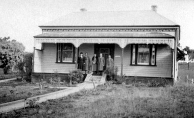
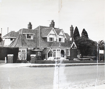
Photograph, Mrs. Norris' House, Linton, 1937
This house was sold by the Knights approx 1970, and moved to the Linton-Piggoreet Road.Black and white original photograph of five people standing on the verandah of a late Victorian house."Mrs Norriss's house Skipton road Linton 1937 later Knights home".houses, mrs norris, knight family -
 Robin Boyd Foundation
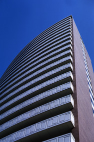
Slide, Robin Boyd, 1965
Colour slide in a mount. BP House (1964), St Kilda Road, Melbourne, Australia. (Architect: Anthony B Armstrong.)Made in Australia / 6 / JAN 65M / B-P St Kilda Road 1964 (Handwritten) / Detail: See also no.7. (Handwritten)melbourne, robin boyd, slide -
 Whitehorse Historical Society Inc.
Document, Ellis Stone's medisan planting, 1/05/2001 12:00:00 AM
'Ellis Stones' median planting, Canterbury Road, Vermont.'Ellis Stones' median planting, Canterbury Road, Vermont. Brochure describing median strip landscaping in Canterbury Road, Vermont undertaken by Ellis Stones in 1974 and details of proposed replanting.'Ellis Stones' median planting, Canterbury Road, Vermont. stones, ellis, canterbury road, vermont, roads and streets, landscape planning, city of whitehorse -
 Lakes Entrance Historical Society
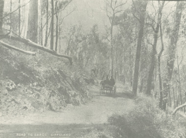
Photograph - road to Dargo Victoria, 1900 c
Road to Dargo GippslandBlack and white photograph of a horse drawn vehicle on a road through bushland on the way to Dargo Victoriatransport, roads and streets, topography -
 Mt Dandenong & District Historical Society Inc.
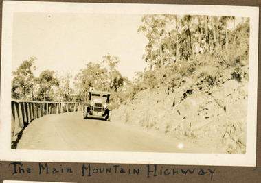
Photograph
The photograph shows an old car rounding a bend on what is now the Mt Dandenong Tourist Road. Around 1930 it would have been called the CRB Road or the Main Road. The photograph is in the Ivy Child Album. Ivy May Child (1910 – 1989) was the daughter of Arthur Edward (Ted) Child (1878 – 1964) and Ethel May Madden (1888 – 1970). Ted Child was the son of Matthew Francis Child (1839 – 1933) and Martha Jeeves (1857 – 1926). He was the grandson of one of the early pioneers Francis Child. Ivy grew up on the family property on Childs Road and took many photographs. Most of these are glued into her photo album. The album covered the years from c1927 – 1932. Ivy married Henry William Burgess (1906 – 1968) in 1944.Sepia coloured photograph showing an old car rounding a bend in the road.Below photograph in album: The Main Mountain Highwaymain road, crb road mt dandenong tourist road, car, automobile, ivy child, kalorama -
 Surrey Hills Historical Society Collection
Photograph - Digital photograph, George L Coop, Whitehorse Road Mont Albert prior to widening, 1958, c1958
The donor George Lister Coop was about 21 years of age when he took this photo in 1958 before Whitehorse Road was widened. It was taken from adjacent to the Coop family home at No.688. Greythorn Caravans factory / showroom / yard was established c1953 at 731 Whitehorse Road. F R Horwood Wrought Iron at 733 Whitehorse Road was established in the 1940s.A digital copy of a colour photograph of Whitehorse Road, Mont Albert looking towards Box Hill. The Box Hill Gasworks can be seen in the middle distance. A caravan retailer can just be seen in the foreground on the northern side of Whitehorse Road.george l coop, whitehorse road, box hill gas works, mont albert, greythorn caravans, f r horwood wrought iron -
 Vision Australia
Drawing - Image, Vision Australia Kensington exterior artists view, 2009
Artist impression of the new building for Vision Australia's office in Macaulay Road, Kensington in 2009.4 digital files depicting artists view of Macaulay Road officevision australia, macaulay road kensington -
 Vision Australia
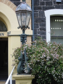
Photograph - Image, Lamp post outside entry to St Kilda Road
Image taken of a lamp outside the reception door of the RVIB St Kilda Road building.1 col. image of lamp outside St Kilda Road buildingroyal victorian institute for the blind, fundraising -
 Kew Historical Society Inc
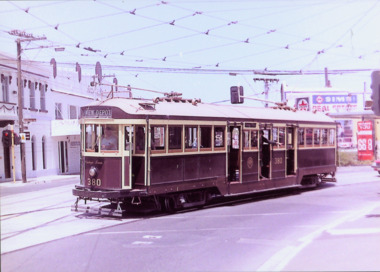
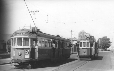
Photograph - W Class 380 turning out of Barkers Road into High Street South, 1990
This colour photograph, with 15 others are enlargements gifted to the Society by Mel Lawrence in 2016. They were taken at a commemorative event from the Kew Tram Depot. Laminated colour enlargement of W Class tram No.380 turning out of Barkers Road into High Street South, during a re-enactment in 1990.Annotation reverse: "Kew Depot 1990. W Class 380 turning out of Barkers Road into High Street South"kew tram depot, trams -- melbourne, a class trams -
 Eltham District Historical Society Inc
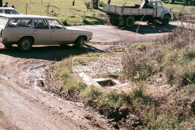
Slide, In Bonds Road south of the northern arm of Montpelier Drive, Lower Plenty, 18 July 1972, 1972
Water drainage work undertaken by Eltham Shire Council in Bonds Road, Lower Plenty outside the Martin property opposite Montpelier Drive, July 1972 Note the blocked pit full of water and water circumnavigating the pit.35 mm colour positive transparency Mount - Agfacolor Service (Blue)Bonds Road (Martin property) 12.10 pm 18.7.72bonds road, drainage works, eltham shire council, infrastructure, lower plenty, martin property, montpelier drive -
 City of Kingston
Pamphlet - Colour, Brock Bros, South Brighton Township Estate, 1888
Sales plan for land in the suburb of South Brighton (Moorabbin), bounded by Point Nepean Road, South Road, Patterson Street and the Mordialloc Railway Line. Incorporates Wolsely Street and Gordon StreetThe developing urban area of Moorabbin within the City of Kingston. This land sale pamphlet illustrates the subdivision of land within the municipality and the changing demographic of the district as new houses are constructed close to infrastructure.Colour pamphlet advertising for private sale the South Brighton Township Estate, South Brighton. Incorporates a map of the estate bordered by Point Nepean Road, South Road, Patterson Street, and the Mordialloc Railway Line. Includes Wolsley Street and Gordon Street. land sales, south brighton, estate, moorabbin -
Whitehorse Historical Society Inc.
Document, History of Tally Ho Boys Home, 1972
Three papers on History of Boys Training Farm, Highbury Road, Tally Ho3 papers on History of Boys Training Farm, Highbury Road, Tally Ho, commenced in 1903 by Rev. and Mrs George Cole. The story covers the period from 1903-1930. The farm was built on land bought from Abel Hoadley for 1,000 Pounds near the corner of Springvale Road in Boundary Road (now Highbury Road). 2 letters (16/7/1972 & 28/5/1972) to Nancy Leach from E. Hinneberg, Assistant Superintendent, Tally Ho, about his association with Tally Ho.Three papers on History of Boys Training Farm, Highbury Road, Tally Hoyouth services, tally ho boys home, cole, george, rev., cole, mrs, hoadley, abel, boundary road burwood east, highbury road, burwood east, springvale road, burwood east, leach, nancy, hinneberg, ernest. -
 Kiewa Valley Historical Society
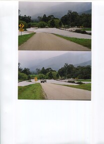
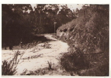
Photos - x2 Damms Road River Crossing
Damms Road river crossing after the c1993 floods of the Kiewa River. The old bridge was inundated, later to be washed away.The Kiewa River flooded in 1993 at Damms Road when the old bridge was washed away.2 coloured photos of the Kiewa River in flood at Damms Roadkiewa river flooding, bridge at damms road -
 Vision Australia
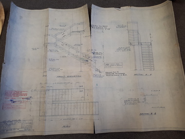
Plan - Image, Section B.B (stairwell), 12/5/1977
Architectural drawing for the completion of a outside stairway at St Kilda Road. Detailed drawing of the stairs, including specifications and measurements and shows the front elevation and two sections.1 architectural plan of stairwell at St Kilda RoadCraftsteel Industries Pty Ltdroyal victorian institute for the blind, plans -
 Melbourne Tram Museum
Photograph - Black and White - Trams 349 & 661, Truganini Road Carnegie, John Alfred
Photo shows W2 349 and W3 661 in Glenhuntly Road / Truganini Road Carnegie (route 4) at the start of the single line to the terminus, with the drivers "exchanging the staff" for the section. The destination of 349 has already been changed. Note the warning sign above the drivers of the Single line section. Photo possibly 1950s.Yields information about the use of the short single line just before the Carnegie terminus.Photograph - Black and White - Trams 349 & 661, Truganini Road CarnegieHas details on rear in ink and John Alfred Stamp.tramways, tramcars, carnegie, truganini road, single line, staff, w2 class, w3 class, tram 661, tram 349, glenhuntly road -
Camberwell Historical Society
Photograph - Photographs, Ella Keesing, Palace Hotel photographs, 1989
Palace Hotel on Burke Road was built in 18899 photographs of Palace Hotel on Burke Road. Photographs taken by Ella Keesing in 1989. camberwell, hotel -
 Halls Gap & Grampians Historical Society
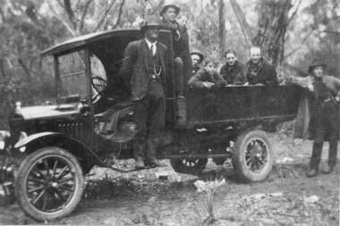
Photograph - B/W, C 1930s
... Roads ...Photo shows construction workers involved with the making of Dunkeld/Grampians Road. One man is standing on the running board of a small truck, six men are seated or standing in the tray, another man is standing on the ground at the back of the vehicle.access routes, roads, people, road gang -
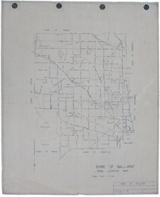 Federation University Historical Collection
Map, Shire of Ballarat Road Location Map, 1968, 05/06/2014
... roads ...White paper road location map. Scale 1 mile to 1 inchballarat, shire of ballarat, roads, dowling forest, lake burumbeet, lake learmonth, ascot, windermere, tourello -
 Kiewa Valley Historical Society
Photograph of Kiewa Valley Panorama, Kiewa Valley from No. 5 Road, Before 1945
In 1943 a camp for workmen was erected and a commencement made with the erection of plant storage and workshop buildings in the new township of Mt. Beauty. The photograph was probably taken after the completion of these buildings. There is no sign of construction of the town itself. In the latter part of 1945 work was commenced on the Mt. Beauty township area with a medical centre, general trading store and some houses under construction. The No. 5 Road, from where the photograph was taken, is the road to West Kiewa Power Station and Big Hill Scenic Lookout.Is an excellent view of the Kiewa Valley before there was little work undertaken to establish the town of Mt. Beauty. Farming was well established with the evidence of huge areas of cleared land. The junction of the East and West Kiewa Rivers can be clearly seen. The first Workmen's camp is near the river and some workshop buildings can also be seen. Black and white photograph of the Kiewa Valley, looking North.Handwritten on the back of photograph "Kiewa Valley from No. 5 Road".kiewa valley, camp, buildings, mt. beauty -
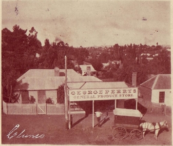 Clunes Museum
Photograph, COPIES BY PURCELL, ROGER BALLARAT, COPIES 1996
GEORGE PERRY'S GENERAL STORE WAS SITUATED IN CRESWICK ROAD. CLUNES, PRESENT SITE OF THE LATE BRENDA TREMBATH 'S HOUSE..1 ORIGINAL SEPIA POSTCARD PHOTOGRAPH OF GEORGE PERRY'S GENERAL PRODUCE STORE IN CRESWICK ROAD, CLUNES POSTAGE STAMP AFFIXED, ONE PENNY .2.3 BLACK AND WHITE COPIES OF THE ABOVE PHOTOGRAPH PRINTED ON GLOSS PHOTOGRAPHIC PAPER .4.5.6 BLACK AND WHITE COPIES OF THE ABOVE PHOTOGRAPH PRINTED ON MATTE PHOTOGRAPHIC PAPER .7 Supplementary FileAddressed to; Mrs. Perry Creswick Road, Clunes Postmarked Jan 15 1907 Handwritten date 12/1/07 "Dear Grandma, I am sending you a post card view of your shop that Dada took. I hope you will like it and trust you are well, Muriel" (Written in black ink) local history, photography, photographs, shops george perry's general store, buildings -
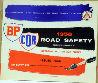 Orbost & District Historical Society
booklet, 1958 Road Safety Colouring Competition, second half 1950's
Between the 1950s and 1970s, road safety was redefined as a medical and social problem, rather than a moral and legal one. This was a time before seat belts. The Road Safety Colouring Competition was a free colouring competition for children, organised by Commonwealth Oil Refineries Ltd., started in August 1954 with the , aims of teaching road safety. There were 1,000 prizes, valued at £1,200. The winner would receive a £100 bursary and a free plane trip with one parent to Canberra to receive the prize from the Federal Minister for Transport, Senator.G. McLeay. This booklet is the one used by the children in Orbost in 1958. This booklet was designed to promote road safety awareness, with messages and activities specifically considered for children. Its aim was to teach road safety in a fun, but educational way. This item was an important educational tool. A booklet of competitions - Road Safety- Victorian Section for Children It was issued by the Australian Road Safety Council. The front cover is blue, red, black and white. It contains crosswords, colouring competitions with entry forms.road-safety competitions-colouring -
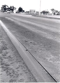 City of Kingston
Photograph - Black and white, c. 1970
This photograph depicts the steel tramway (or tram plate) along Centre Dandenong Road, Cheltenham near the Moorabbin Airport entrance in the 1970's. These tramways played an important role in transportation along Moorabbin's major roads. Heavily laden carts could travel smoothly and safely along the steel plates when the road surfaces were often rutted and hazardous. This surviving section was later moved for road improvements. The area now known as the City of Kingston was a market garden region and the round trip to market could take as long as eight hours on poorly maintained roads. The installation of the steel tramway transformed the arduous journey faced by market gardeners in transporting their produce to market. As there was only a single tramway, the carts often travelled in convoy, enabling drivers to leave piloting to the first cart and having a rest. The rails did not speed the journey to the city, but it smoothed progress immeasurably. Black and white photograph of steel tram plates on Centre Dandenong Road, Cheltenham. The road is sealed. At the top of the image there are trees behind a parked car which is adjacent to a white shelter. There is a large sign stating MOORABBIN AIRPORT above an arrow pointing to the right in the top centre of the image. Handwritten in pencil: A 28 / [indecipherable] 3 / [indecipherable] Handwritten in red ink: A28 / 70%market gardening, infrastructure, transport, steel tramway, industry, moorabbin -
Whitehorse Historical Society Inc.
Document, Gallus Family, 1851-1976
Gallus family history in Vermont.Gallus family history in Vermont. They owned a poultry farm on the corner of Boronia and Centre RoadsGallus family history in Vermont.gallus, e.e, gallus, dianne, gallus, cynthia, poultry farms -
 Melbourne Legacy
Photograph, Harelands, 9/9/1963
The Harelands property in Kew, was used as a residence for Junior Legatees (Legacy Beneficaries) up to the age of 14 years. It operated during the 1960’s and 1970’s.Melbourne Legacy established residences to aid children of deceased servicemen complete their education, take further education and find employment.Black and white photo of Harelands, Willsmere Road, Kew. Handwritten 'Harelands 1963 Willsmere Road, Kew up to 14 year-olds Residence for Junior Legatees'. Stamped 'Property of Melbourne Legacy' in purple ink. Stamped with photographers details and order number (P2976/7) and date (9/9/63).harelands, residences, properties -
 Lakes Entrance Historical Society
Photograph - Old Bungs Rd. 1927, c1927
This was the old coach road to Orbost which went from Lakes Entrance to Orbost via Lake Tyers.Black and White photograph of old Bunga Road crossing, Lake Tyers.roads and streets, development -
 Ringwood and District Historical Society
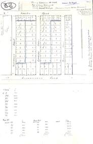
Plan, Plan of Subdivision No.11498 with handwritten costing notations - East Ringwood Central Estate c.1948
Two handwritten pages showing layout of Subdivision no 11498 with surveyor notations including property sizes and road construction cost calculations. Drainage easement 6 feet wide shaded blue.Plan of Subdivision No. 11498, Part of Crown Allotment 27, Parish of Ringwood, County of Mornington, (Certificate of Title Vol 5120 Fol 1023945). Owner Mr Vogel. Subdivision includes Knaith Road, Northwood Street, Langley Street, Bondi Street, and Government Road (later Alexandra Road), Ringwood East. G. Parsons & Sons, Licensed Surveyors, 389 Flinders Lane (Melbourne). -
 Marysville & District Historical Society
Photograph (Item) - Colour photograph, Unknown
A digital copy of a colour photograph taken along Falls Road in Marysville in Victoria.A digital copy of a colour photograph taken along Falls Road in Marysville in Victoria.falls road, marysville, victoria, photograph -
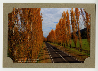 Marysville & District Historical Society
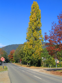
Photograph (item) - Colour photograph, Donovan Wilson, 'GOULDS MEMORIAL DRIVE'- Buxton Marysville Road, Post 2009
A colour photograph taken of Goulds Memorial Drive on the Buxton Marysville Road in Victoria.A colour photograph taken of Goulds Memorial Drive on the Buxton Marysville Road in Victoria. The planting of the avenue of Lombardi Poplars was initiated by Mrs Joy Gould and the trees were planted by workers of the Gould Mill. The intention was for the avenue to extend from Marysville to Buxton. However, this was never fully realised. In Autumn the trees turn a brilliant yellow and are a major tourist attraction. marysville, buxton, poplar trees, gould memorial drive, donovan wilson, postcard, souvenir, marysville-buxton road -
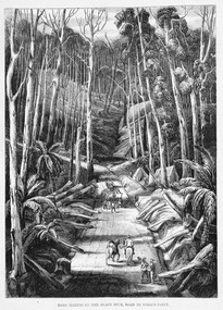 Marysville & District Historical Society
Work on paper (item) - Print of wood engraving, Ebenezer and David Syme, Road Making on the Black Spur, Road to Wood's Point, 1867
A copy of an early wood engraving of the construction of the road over the Black Spur in Victoria.A copy of an early wood engraving of the construction of the road over the Black Spur in Victoria. The Black Spur is known to be one of Victoria's most scenic drives. The road winds through a majestic forest of trees and tree ferns from Healesville to Narbethong and is part of the Maroondah Highway.black spur, wood's point, narbethong, maroondah highway, victoria, wood engraving -
Marysville & District Historical Society
Document (Item) - Newspaper article, The Argus, New Tourist Road. Marysville to Wood's Point Magnificent Forest Scenery, 02-1924
A newspaper article regarding the opening of the Marysville-Wood's Point Road in February 1924.A newspaper article regarding the opening of the Marysville-Wood's Point Road in February 1924. The Marysville-Woods Point Road was originally part of the Yarra Track, constructed in the early 1860s to provide access between Healesville and the Woods Point Goldfields. Despite the steep terrain and engineering difficulties, the Yarra Track soon became a busy route used by pack horses, horse-drawn drays, and wagons. Today this sealed mountain road is a popular scenic drive between Marysville and Warburton.marysville-wood's point road, yarra track, healesville, wood's point goldfields, warburton, the argus