Showing 1224 items
matching sale of land
-
 Bendigo Historical Society Inc.
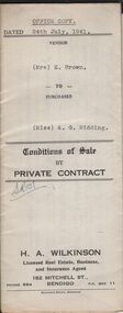
Document - H.A. & S.R. WILKINSON COLLECTION: CONDITION OF SALE
Conditions of sale by private contract dated 24th July, 1941 between Mrs. E. Brown (seller) and Miss A.G. Ridding (buyer) for land situate No.73 Honeysuckle Street, Bendigo being part of Crown allotment 6 section 14B described in Crown grant volume 1056 folio 211103, together with 4-roomed weatherboard and rough cast dwelling and all sundry. Price 615 pounds.organization, business, h.a. & s.r wilkinson real estate -
 Bendigo Historical Society Inc.
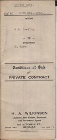
Document - H.A. & S.R. WILKINSON COLLECTION: CONDITION OF SALE
Conditions of sale by private contract dated 20th May, 1943 between A.E. Cowling (seller) and H. Rice (buyer) for land situate Wood Street, Long Gully having a frontage of 150 links to Wood Street by a depth of 200 links and being the land described in right to occupy residence area title No. 4719 due 23/08/1943, together with 5-roomed weatherboard dwelling and all sundry. Price 225 pounds.organization, business, h.a. & s.r wilkinson real estate -
 Bendigo Historical Society Inc.
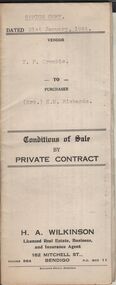
Document - H.A. & S.R. WILKINSON COLLECTION: CONDITION OF SALE
Conditions of sale by private contract dated 21st January, 1944 between T.F. Crombie (seller) and Mrs E.M. Richards (buyer) for land situate 101 Anderson Street, Bendigo being Crown allotment 538 section K described in Crown grant volume 2944 folio 538737, together with 5-roomed brick dwelling and all sundry. Price 450 pounds.organization, business, h.a. & s.r wilkinson real estate -
 Bendigo Historical Society Inc.
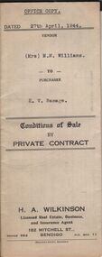
Document - H.A. & S.R. WILKINSON COLLECTION: CONDITION OF SALE
Conditions of sale by private sale dated 27th April 1944 between Mrs M.M. Williams (seller) and H.V. Ramage (buyer) for land situate Cohn Street near Holdsworth Road, Bendigo, being allotment 16 section K1, containing 2 acres, 1rood and 20 perches more or less in the City of Bendigo, described in Crown grant volume 6207 folio 1241225, together with 4-roomed weatherboard building, iron tank and all sundry. Price 33 pounds.organization, business, h.a. & s.r wilkinson real estate -
 Bendigo Historical Society Inc.
Document - H.A. & S.R. WILKINSON COLLECTION: CONDITION OF SALE
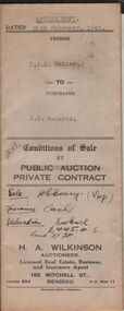
Conditions of sale by private contract dated 28th February, 1946 between N.J.M. Walker (seller) and N.S.Roberts (buyer) for land situate at 59 Norfolk Street, Bendigo having a frontage of 198 links to Norfolk Street by a depth of 250 links land described in right to occupy residence area No. 5105, together with 5-roomed weatherboard dwelling and all sundry. Price 450 pounds.organization, business, h.a. & s.r wilkinson real estate -
 Bendigo Historical Society Inc.
Document - H.A. & S.R. WILKINSON COLLECTION: CONDITION OF SALE
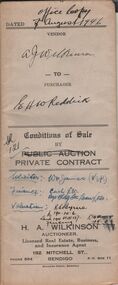
Conditions of sale by private contract dated 7th August, 1946 between A.J. Wilkinson (seller) and E.H.W. Reddick (buyer) for land situate in McKenzie Street West, Golden Square, being Crown allotments 6B and 6C section 44B described in certificate of title 4304 folio 860637. Price 150 poundsorganization, business, h.a. & s.r wilkinson real estate -
 Bendigo Historical Society Inc.
Document - H.A. & S.R. WILKINSON COLLECTION: CONDITION OF SALE
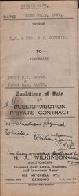
Conditions of sale by private contract dated 22nd July, 1947 between N.E. & Mrs. B. E. Woodall (sellers) and Mrs N.I. Rigby & Mrs D.M. Sayer (buyer) for land situate 86 Violet Street Bendigo, at present occupied by Mr. Bice as tenant, being the land in conveyance registered No. 66, book 589. Also the land untransferred in certificate of title volume 5350 folio 1071748 Crown allotment 19 section 11B, together with 5-roomed brick and weatherboard dwelling and all sundry. Price 600 pounds.organization, business, h.a. & s.r wilkinson real estate -
 Bendigo Historical Society Inc.
Document - H.A. & S.R. WILKINSON COLLECTION: CONDITION OF SALE
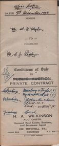
Conditions of sale by private contract dated 9th December 1948 between Mr. William Francis Mylon (seller) and Mr. Samuel John Rigby for land at 23 Grant Street Long Gully described in residence licence No. 0552129, together with 5-roomed brick and weatherboard dwelling and all sundry. Price 510 pounds.organization, business, h.a. & s.r wilkinson real estate -
 Bendigo Historical Society Inc.
Document - H.A. & S.R. WILKINSON COLLECTION: CONDITION OF SALE
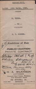
Conditions of sale by private contract issued by H.A. Wilkinson and dated 15th March, 1949 between W. Young (seller) and C.P. Rogers (buyer) for land situate in Brown Street Eaglehawk having a frontage of 129 links to Brown Street , by a depth of 192 links and being described in right of occupy residence area No. 5412, together with 5-roomed weatherboard dwelling and all sundry. Price 480 pounds.organization, business, h.a. & s.r wilkinson real estate -
 Bendigo Historical Society Inc.
Document - H.A & S.R. WILKINSON COLLECTION: CONDITION OF SALE
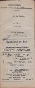
Conditions of sale by private contract issued by Bishop & Earl and H.A. Wilkinson and dated 25th July, 1949 between C.M. Taylor(seller) and F.W. Rogers + D.J. Rogers (buyers) land situate No. 47 Reginald Street Bendigo at present occupied by the purchaser as tenant, being part of Crown allotment 23 section 104C described in Crown grant volume 2052 folio 410334 as per plan of subdivision approved by the Bendigo Council, together with 4-roomed weatherboard dwelling and all sundry. Price 1,100 poundsorganization, business, h.a. & s.r wilkinson real estate -
 Bendigo Historical Society Inc.
Document - H.A. & S.R. WILKINSON COLLECTION: CONDITION OF SALE
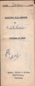
Contract of sale issued by Hyett, Willis & Hyett Solicitors and dated 30th November 1949 between the executors of W.H. Hammond Estate (seller) and G.A. Risstrom (buyer). Sale of freehold property situate at 11 Vine Street, Bendigo and all that piece of land on the western side of Vine Street about 118 links southerly from High Street with a frontage of 68 links by a depth of 80 links and a width at the rear of 31 links described in right to occupy a residence area No. 4796 in the books of the Land Department together with all improvements. Price 500 poundsorganization, business, h.a. & s.r wilkinson real estate -
 Bendigo Historical Society Inc.
Document - H.A. & S.R. WILKINSON COLLECTION: CONDITION OF SALE
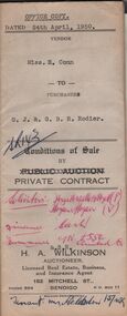
Conditions of sale by private contract issued by H.A. Wilkinson and dated 24th April, 1950 between Miss E. Conn (seller) and G.J. & G.B.R. Rodier (buyer) for land situate Pitt Street Bendigo, at present occupied by Mrs. Holsdon as tenant, having a frontage of 66ft. By a depth of 82.5ft. Part of Crown allotment 6 section 60B described in certificate of title volume 2538 folio 507552, together with 6-roomed weatherboard dwelling and all sundry. Price 700 pounds.organization, business, h.a. & s.r wilkinson real estate -
 Bendigo Historical Society Inc.
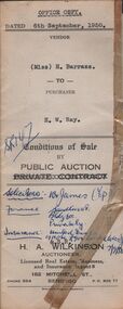
Document - H.A. & S.R. WILKINSON COLLECTION: CONDITION OF SALE
Conditions of sale by public auction issued by H.A. Wilkinson and dated 6th September 1950 between miss H. Barrass (seller) and H. W. Ray (buyer) for land situate No. 139 Queen Street Bendigo at present occupied by Mr. L.J. Lobb a tenant, being lot 1 on plan of subdivision made by Mr. A.E. Pritchard dated 13th August 1950 and being part of Crown allotment 10 section 90C, together with 5-roomed weatherboard dwelling and all sundry. Subject to existing weekly tenancy. Price 870 pounds.organization, business, h.a. & s.r wilkinson real estate -
 Bendigo Historical Society Inc.
Document - H.A. & S.R. WILKINSON COLLECTION: CONDITION OF SALE
Conditions of sale by private contract issued by H.A. Wilkinson and dated 25th September 1950 between George Franklin Humphrey & Ethel May Humphries (sellers) and Ernest James Robinson (buyer) for land situate Williams Road Eaglehawk being Crown allotment378 section A Borough of Eaglehawk described in Crown grant volume 3816 folio 763025, together with 4-roomed weatherboard dwelling and all sundry. Price 1,000 pounds.organization, business, h.a. & s.r wilkinson real estate -
 Bendigo Historical Society Inc.
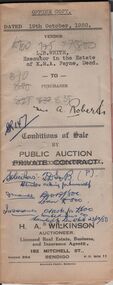
Document - H.A & S.R. WILKINSON COLLECTION: CONDITION OF SALE
Conditions of sale between private contract issued by H.. Wilkinson and dated 19th October, 1950 between L.B. White, Executor in the estate of K.M.A. Payne (seller) and A. Roberts for land situate No. 18 Hayes Street Bendigo being part of Crown allotment 500A section A Parish of Sandhurst, City and County of Bendigo and being the land remaining in Crown grant volume 6276 folio 1255184, together with 4-roomed weatherboard dwelling and all sundry. Price 835 pounds.organization, business, h.a. & s.r wilkinson real estate -
 Bendigo Historical Society Inc.
Document - H.A. & S.R. WILKINSON COLLECTION: CONDITION OF SALE
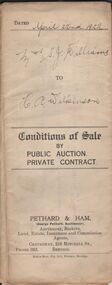
Conditions of sale by private contract dated 22nd April, 1922 issued by Pethard & Ham between Sarah Jane Williams (seller) and Henry Archibald Wilkinson (buyer) for land part of Crown allotment 54 section M Parish of Sandhurst, city and county of Bendigo described in certificate of title no. 2500 folio 499984. Also part of Crown allotments No. 53 and 54 certificate of title volume 2545 folio 508851, together with 7-roomed brick dwelling. Price 415 pounds Also for documents from Tatchell,Dunlop, Smalley & Palmer Solicitors to Mr. H.A. Wilkinson details the settlement of the Williams estateorganization, business, h.a. & s.r wilkinson real estate -
 Bendigo Historical Society Inc.
Document - H.A. & S.R. WILKINSON COLLECTION: CONDITION OF SALE
Conditions of sale by private contract, dated 9th November 1922 issued by Pethard & Ham between George Ford Sansom (seller) and Henry A. Wilkinson ( buyer) for land situate Bakewell Street Bendigo. Crown allotment 331 section E Parish of Sandhurst city and county of Bendigo described in certificate of title volume 1784 folio 356656, together with 5-roomed brick and rough cast house and all sundry. Price 375 poundsorganization, business, h.a. & s.r wilkinson real estate -
 Bendigo Historical Society Inc.
Document - H.A. & S.R. WILKINSON COLLECTION: CONDITION OF SALE
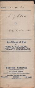
Conditions of sale by private contract issued by George Pethard, dated 12th April 1923 between Sarah Jane Odgers (seller) and Frederick Charles Neivandt (buyer) for land situate at 70 Lilac Street described in residence area certificate of registration No. 6830 together with 6-roomed weatherboard house and all sundry. Price 160 pounds.organization, business, h.a. & s.r wilkinson real estate -
 Bendigo Historical Society Inc.
Document - H.A. & S.R. WILKINSON COLLECTION: CONDITION OF SALE
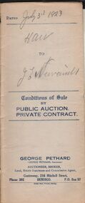
Conditions of sale issued by George Pethard, dated 31st July 1923 between Henry Archibald Wilkinson (seller) and Jane Elizabeth Neivandt (buyer) for land situate in Lilac Street Bendigo described in certificate of registration No. 6830, together with 6-roomed weatherboard house and all sundry. Price 320 pounds.organization, business, h.a. & s.r wilkinson real estate -
 Bendigo Historical Society Inc.
Document - H.A. & S.R. WILKINSON COLLECTION: CONDITION OF SALE
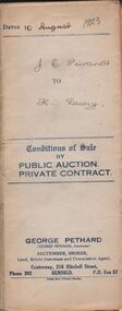
Conditions of sale by private contract issued by George Pethard dated 10th August 1923 between Jane Elizabeth Neivandt (seller) and Kate Lawry (buyer) for land situate in Lilac Street Bendigo between Vertelhausen's and Bowan's residence areas land described in certificate of registration of residence area No. 20225, together with 7-roomed dwelling and all sundry. Price 350 pounds.organization, business, h.a. & s.r wilkinson real estate -
 Bendigo Historical Society Inc.
Document - H.A. & S.R. WILKINSON COLLECTION: CONDITION OF SALE
Conditions of sale by private contract issued by George Pethard dated 15th April, 1924, between George Pethard acting on behalf of The Manchester Unity Independent Order of Oddfellows Bendigo District Widows and Orphans Fund as Mortgagees and Henry Archibald Wilkinson (buyer), land situate at no. 121 Mundy Street Bendigo at present occupied by Mr. Spencer as tenant. Crown allotment 10 of section 8c Parish of Sandhurst city and county of Bendigo described in certificate of title volume 2732 folio 546267 having a frontage of 125 links by a depth of 200 links. Together with six-roomed brick house and all sundry. Price 500 pounds.organization, business, h.a. & s.r wilkinson real estate -
 Bendigo Historical Society Inc.
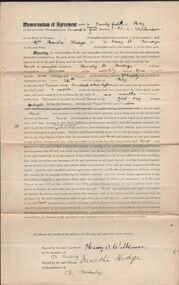
Document - H.A. & S.R. WILKINSON COLLECTION: CONDITION OF SALE
Memorandum of agreement dated 21st May, 1924 between Mr. H. Wilkinson (landlord) and Mrs. M. Hodge (tenant). The tenant agrees to take from the landlord the land & premises situate in Mundy street Bendigo and last occupied by Spencer at the weekly rent of 1 pound and 1 shilling payable fortnightly, such tenancy to commence on the 26th May, 1924 and not cease until 1 week notice in writing shall have been given by either party to the other.organization, business, h.a. & s.r wilkinson real estate -
 Bendigo Historical Society Inc.
Document - H.A. & S.R. WILKINSON COLLECTION: CONDITION OF SALE
Conditions of sale by private contract issued by George Pethard Auctioneer and dated 9th June, 1924 between H. A. Wilkinson as seller and F. R. Rosan as buyer. Land situate at 121 Mundy Street Bendigo at present occupied by Mrs. Hodge as tenant being Crown allotment 10 of section 8C Parish of Sandhurst city and county of Bendigo described in certificate of title volume 2732 folio 546267 and having a frontage of 125 links by a depth of 200 links, together with 6-roomed brick house and all sundry. Price 575 pounds.organization, business, h.a. & s.r wilkinson real estate -
 Bendigo Historical Society Inc.
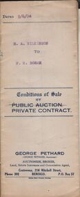
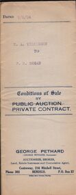
Document - H.A. & S.R. WILKINSON COLLECTION: CONDITION OF SALE
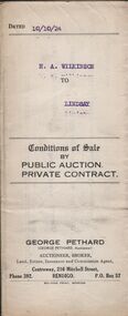
Conditions of sale by private contract issued by George Pethard Auctioneer and dated 10th October 1924 between H. A. Wilkinson as seller and H. A. Lindsay as buyer. Land situate corner of Peel and Hamlet Streets Bendigo being Crown allotment 2 section 145C Parish of Sandhurst City and county of Bendigo described in certificate of title volume 2935 folio 566916, together with 5-roomed weatherboard house and electric fittings, copper, bath and all sundry. Price 312 pounds and 10 shillings.organization, business, h.a. & s.r wilkinson real estate -
 Bendigo Historical Society Inc.
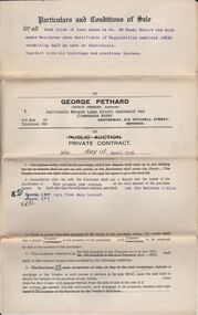
Document - H.A. & S.R. WILKINSON COLLECTIONCONDITION OF SALE
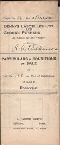
Particulars & conditions of sale of lot no. 188 on plan of subdivision of land at Robinvale between Dennys Lascelles Ltd + George Pethard as agents for the vendor and H. A. Wilkinson (buyer). Price 63 pounds.organization, business, h.a. & s.r wilkinson real estate -
 Bendigo Historical Society Inc.
Document - H.A. & S.R. WILKINSON COLLECTION: CONDITION OF SALE
Conditions of sale by private contract dated 25th April, 1925 between M. J. Buchanan and F. C. Neivandt for land situate at 343 High Street described in certificate of title volume 3263 folio 652436, together with remains of 4-room brick and weatherboard house. Price 40 pounds.organization, business, h.a. & s.r wilkinson real estate -
 Bendigo Historical Society Inc.
Document - H.A. & S.R. WILKINSON COLLECTION: CONDITION OF SALE
Conditions of sale by private contract dated 29th April, 1925 between H. A. Wilkinson and G. A. Pethard for land being lot 188 at Robinvale part of allotment A Parish of Bumbang County of Karkarooc, together with 6-roomed dwelling. Price 505 pounds and 10 shillings.organization, business, h.a. & s.r wilkinson real estate -
 Bendigo Historical Society Inc.
Document - H.A. & S.R. WILKINSON COLLECTION: CONDITION OF SALE
Conditions of sale by private contract dated 11th May, 1925 between F. C. Neivandt and M. Hogan for land situate at 343 High Street described in certificate of title volume 3263 folio 652436, together with remains of 4-roomed brick and weatherboard house. Price 75 pounds.organization, business, h.a. & s.r wilkinson real estate -
 Bendigo Historical Society Inc.
Document - H.A. & S.R. WILKINSON COLLECTION: CONDITION OF SALE
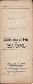
Condition of sale by private contract dated 30th May, 1925 between E. Dobbie and F. C. Neivandt for land at 20 Casey Street held under residence area certificate of registration No. 10890 containing half an acre, together with all buildings. Price 155 pounds.organization, business, h.a. & s.r wilkinson real estate