Showing 876 items matching "shop on corner"
-
 Charlton Golden Grains Museum Inc
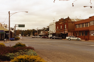
Photograph, High St Charlton c. 1988, c.1988
High St Charlton looking west from the Armstrong St corner. Buildings on the RH side are the Globe Hotel, Bilton/Dillon building, Westpac Bank, Arundell's Shoe Store. Shire of Charlton photo taken after footpath renovations in 1987-88Colour photograph of High St Charlton looking west from the Armstrong St corner. Buildings on the RH side are the Globe Hotel, Heather's Choice Gift Shop, Mallee Kitchen, Charlton Pharmacy, Westpac Bank. White car parked in front of Globe Hotel building. Bush Poet Cafe sign on LH side of photo.charlton, globe hotel, bilton building, westpac bank, arundell's shoe store, business, armstrong street -
 Ringwood and District Historical Society
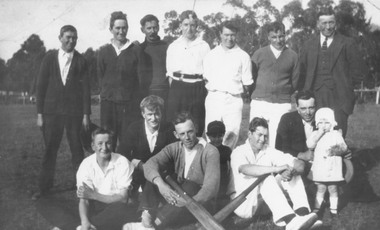
Photograph, First Heathmont Cricket Club in 1922 (social)
Written on back of photograph, "First Heathmont Cricket Club. Taken on oval on the corner of Canterbury and Heathmont Roads, Lisgoold St side. Shops now occupy this area. Back row: F. Pump, H. Pump, E. Nobbs, W. Pump, S. Wieland, B. Godfrey, Mr. F. Wieland, President. Front row: G. Pump, E. Pump, L. Miller, D. Sharp, N. Wieland, F. Clota, D. Sharp. See 'Mail' 7/10/1965". -
 Melbourne Tram Museum
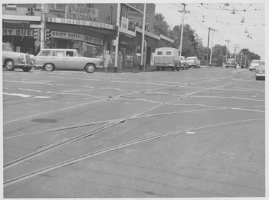
Photograph - Malvern Road and Glenferrie Road intersection, 1960s
Photograph of Malvern Road and Glenferrie Road intersection showing the tram track H crossing with dual turnouts on the southwest and southeast corners. The tram tracks are at a lower level than bitumen roadway causing a rough undulating surface for motor vehicles. Extra works lighting is hanging from the overhead on one side of the junction suggesting future night works. This junction would eventually be relaid in mass concrete. A milk bar advertising various ice creams and other small shops are located at the intersection. Yields information about deterioration of tramway tracks and need for maintenance or replacement. Black and white photograph with no notemalvern road, glenferrie road, junction, works lighting, milk bar, mass concrete -
 Stawell Historical Society Inc
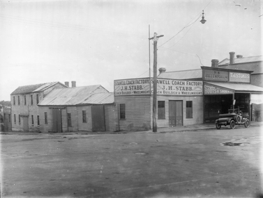
Photograph, J.H. Stabb coach building factory with car parked in front c1920's, c 1920's
J.H. Stabb coach building factory 1920's with car parked in front. B/W Photograph of weatherboard factory. with a two sided sign reaing Stawell Coach Factory J.H. Stabb Coach Builders & Wheelwright. There is a car on the right of the photgraph. Tow shop to the right of factory with a veranda. There is Light pole on the corner.Sign Reads Stawell Coach Factory Trimming a Speciality J.H. Stabb Coach Builders & Wheelwrightstawell industry, j.h. stabb, coachbilders -
 Lakes Entrance Historical Society
Photograph - Site of original Harbecks store, M Holding, 2006
... on corner and Senior Citizens Op Shop facing Carpener Street , Dr... shop facing Esplanade, Wells Fargo on corner and Senior... on corner and Senior Citizens Op Shop facing Carpener Street , Dr ...western corner of Carpenter Street and Esplanade shows Surf Shop and Fish and Chip shop facing Esplanade, Wells Fargo on corner and Senior Citizens Op Shop facing Carpener Street , Dr. Filewoods office extreme right side Lakes Entrance Victoria. Site of original Harbecks storeColour photograph of businesses near western corner of Carpenter Street and Esplanade shows Surf Shop and Fish and Chip shop facing Esplanade, Wells Fargo on corner and Senior Citizens Op Shop facing Carpener Street Dr. Filewoods office extreme right side Lakes Entrance Victoriabusinesses, restaurant, buildings -
 Bendigo Historical Society Inc.
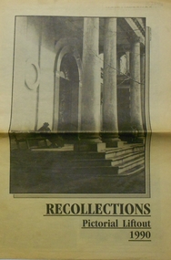
Newspaper - PETER ELLIS COLLECTION: RECOLLECTIONS PICTORIAL LIFTOUT
Historical lift out. Newspaper. Titled RECOLLECTIONS Pictorial Lift out 1990.1 looking down Mitchell St. from Railway Bridge. 2 Original railway station viewed from Mitchell St. bridge. 3 The great extended Hustlers mine. 4 1873 photo recently extended town hall with corn exchange at front left. 5 looking north westerly from city rec reserve at royal hustlers. 6 children play on mullock heap in front of a view of westerly quarter of Sandhurst. 7 Bank of Victoria, Mitchell St. left is Bendigo's original post office. 8 Looking down from what is now Rosalind Park. Shamrock Hotel can be seen on corner of Williamson St. and Pall Mall. This photo predates the construction of post office and law courts. 9 girl eating fairy floss. 10 4 kids on 1 horse in procession. 11 monkey and pedal car, a novelty attraction 1940's. 12 pony rides. 13 flying horses (ride). 14 processions past city hall. 15 Original ANZ bank corner Williamson St. & Pall Mall. 16 Chinese Dragons Bendigo Easter Fair 1940's. 17 City Hall viewed from Bull St. 18 City Hall original ceiling. 19 new town hall 1861. Mike Butcher, local historian. 21 Interior plan of city hall (ground floor) 22 circa 1920's 23 Tattered fragment original architect's drawing. 24 original assembly room. 25 Camp Hill PS Shamrock hotel without top story 27 shop with signage advertising Bushells, Bex and Swallow's Biscuits. 28 View from where fountain is now. 29 Hargreaves St. Looking south, now Hargreaves mall. Horse drawn water tank watering down road. 30 Central Deborah Gold mine poppet head. 31 Borough town hall, tram ways. 32 Original ANZ Bank corner Williamson St. and Pall Mall, demolished in mid 1960's. 33 Bush's store corner Williamson and Myer streets.34 Men on boat, don't know what or where. 35 Shearers. 36 men on a three wheeled bike. 37 4 Gold miners with shovels. 38 6pm closing, no trade Sundays, no women in main bar. 39 Peaceful scene Castlemaine 1940's Photographer Alan Doney. 40 Qantas Jet the City of Bendigo Tullamarine Airport. BCV-8 camera man & Advertiser photographer. 41 Ladies. 42 Tennis -> men and women (women in hats). 43 Sandhurst footy team. 44 Early school photos.bendigo, history, photographic history -
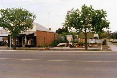 Charlton Golden Grains Museum Inc
Photograph, Charlton Shire, c.1987
... Corner High Street and Learmonth Street. 2 shops demolished ...Corner High Street and Learmonth Street. 2 shops demolished by Greg Fatheres. Shop on left Paterson's fruit and veg c.1935. Butchers shop. rebuilt by Graeme Turner, Marini's take away cafe. Dalgety's, Building at back home of Sheisa Volch facing Learnmouth Street.Corner High Street and Learmonth Street, 2 Shops demolished by Greg Fathersdemolition, charlton, high street, shops, butcher, business, dalgety's, paterson -
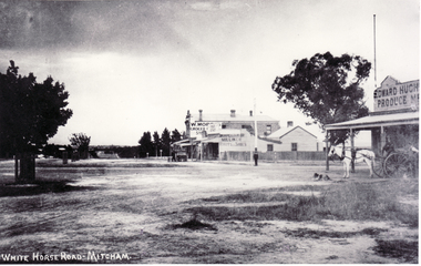 Whitehorse Historical Society Inc.
Photograph, North Corner of Whitehorse & Mitcham Road, Mitcham, c1920's
... .|The vacant land on the far corner became a grocers shop and later... and offices.|The vacant land on the far corner became a grocers shop ...Black and white photo of the northern cnr Whitehorse and Mitcham Roads, Mitcham, showing Hughs Produce Store, with his white horse and delivery waggon outside. This was later the site of Mirama Court, later to be refurbished as shops and offices.|The vacant land on the far corner became a grocers shop and later the Westpac Bank. It is currently (2005) a computer sales shop.hughes produce store, mitcham road, mitcham, whitehorse road mitcham, mirama court mitcham, westpac bank -
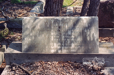 Eltham District Historical Society Inc
Negative - Photograph, Harry Gilham, Grave of Ellen and Ernest James Andrew, Eltham Cemetery, Victoria, Sep 2009
Ernest James Andrew was the son of William Bravery and Ellen Andrew. The Andrews moved to Eltham in the 1850s and opened a produce store on "Policeman's Hill", at the corner of Maria Street (now Main Road) and Franklin Street. William took a lively interest in the public affairs of the town and district, and with his wife Ellen continued to run the store for some fifty years. He died in 1907 and is buried with his wife in Eltham Cemetery. Ernest took over the business, which became a general store and newsagency. Later, it shifted to the main Eltham shopping centre as a combined newsagency and haberdashery/clothing shop. The original weatherboard building at the corner of Franklin Street was replaced around 1940 by a brick structure, which is now a cafe called Zen Den. Ernie too was married to an Ellen and they lived in Arthur Street at so-called "Cook's Cottage" (due to its resemblance to Captain Cook's Cottage in Fitzroy Gardens). He was an Eltham Shire Councillor between 1920 and 1950 and was Shire President for 1930 and 1947 as well as a Trustee for the Eltham (Public) Hall in Henry Street from the time it was purchased in 1922 until 1940. Andrew House at Eltham High School and Andrew Oval in Diamond Street are named after him. Ernie died in 1950 and is buried with Ellen in Eltham Cemetery. In his Will he made provision to the Eltham War Memorial Trust for funding of the Eltham War Memorial Gates – “These Memorial Gates were donated by the Late Cr. And Mrs E.J. Andrew”. In Memory Of Ellen Beloved Wife of E.J. Andrew Died 13th July 1946 Faithfull Always Also the Above Ernest James Andrew Died 29th March 1950 Councillor Shire of Eltham 30 YearsRoll of 35mm colour negative film, 6 stripsKodak GC 400-9eltham cemetery, gravestones, councillors, ellen andrew, ernest james andrew, shire of eltham -
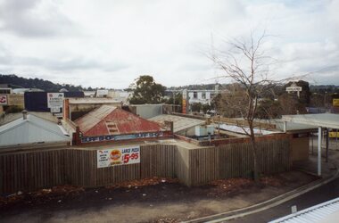
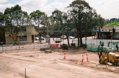 Ringwood and District Historical Society
Photograph, Ringwood Railway Precinct in 2009, facing west towards former CE Carter premises and Melbourne Street, showing demolished corner shops
... demolished corner shops Photograph ... -
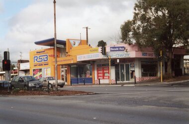 Ringwood and District Historical Society
Photograph, Ringwood Railway Precinct in 2009, showing corner shops on easterly corner of the entrance to the Station
... Ringwood Railway Precinct in 2009, showing corner shops ... -
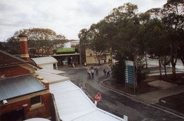
 Ringwood and District Historical Society
Photograph, Ringwood Railway Precinct circa 2008, showing the shops on north-east corner and station entrance, facing east
... Ringwood Railway Precinct circa 2008, showing the shops ... -
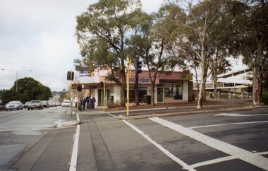
 Ringwood and District Historical Society
Photograph, Ringwood Railway Precinct circa 2008, showing the shops on north-west corner, and station entrance
... Ringwood Railway Precinct circa 2008, showing the shops ... -
 Ringwood and District Historical Society
Photograph, Ringwood Railway Precinct circa 2008, showing the shops on north-east corner, facing north
... Ringwood Railway Precinct circa 2008, showing the shops ... -
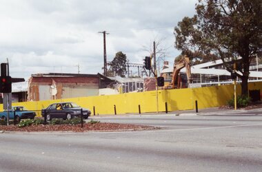 Ringwood and District Historical Society
Photograph, Ringwood Railway Precinct circa 2009, demolishing the shops on north-east corner of entrance
... Ringwood Railway Precinct circa 2009, demolishing the shops ... -
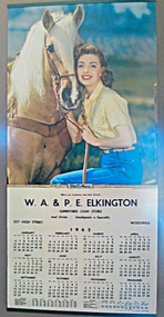 Wodonga & District Historical Society Inc
Ephemera - Sunnyside Cash Store Calendar, 1963
Sunnyside Cash Store was located on the corner of High Street and Wilson Streets Wodonga. It was built and operated by Bill and Ethel Elkington about 1947. The building is in Art Deco style with an awning, verandah and rendered brick parapet behind which was a pitched roof. The shop front originally featured black tile surrounds which have since been removed. The Ice Cream Cone at the front of the building was unfortunately stolen. Apart from a brief period in the early 2000s, the premises has operated as a corner store or café continuously since it was built. In 2025 it still operates as a café called Delibean.This calendar is significant because it documents a business operated by a prominent Wodonga family.Coloured Calendar for Sunnyside Cash Store and a photograph of the Sunnyside Cash StoreW. A. & P. E. ELKINGTON SUNNYSIDE CASH STORE 237 High Street Wodongawodonga businesses, elkington family, wodonga cafes, sunnyside wodonga -
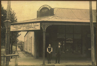 Bacchus Marsh & District Historical Society
Photograph, Ryan's Corner Shop and Refreshment Rooms. 1923
... Ryan's Corner Shop and Refreshment Rooms. 1923..... At the corner stands an ornate iron gas lamppost. Ryan's Corner Shop ...This building on the corner of Main and Gell Streets, comprised of two shops, a residence and sheds at the back, was built by Jeremiah Ryan in 1886-7. It became known as "Ryan's Corner". The first usage as mentioned in the Bacchus Marsh Express was as a jewellery in one shop and a fish and oyster shop combined with Watson's agency business in the other. Over the years, a variety of businesses operated in the two shops, including a barber shop, auctioneer and land agent premises, a hairdresser, solicitor's, costumiere, and bootmaker. Joseph Burbidge operated a greengrocery on this site for several years until the corner store was purchased in 1903 and became an ABC Cafe. Various businesses continued to operate on the site, with the neighbouring ABC cafe continuing in business with a number of different proprietors. The cafe was taken over by Miss Mary O'Donnell in 1922, assisted by Mr "Bill" Day, who became a business partner in 1924. In 1935, Miss O'Donnell sold her share of the business to Mr Day, who continued to operate the tea rooms with his wife. He remained the sole proprietor until his death in 1963. Because he was a well-known shop-keeper in the town over a period of forty years, his establishment became known locally as "Bill Day's Corner". In 1968 the building was demolished for the Commonwealth Bank, which continues to operate on this site.Black and white photograph mounted on brown cardboard. Photograph of M. O'Donnell A.B.C. Refreshment Rooms with a young woman and a gentleman standing outside on the footpath. They can be identified as Virgie McCusker and W.J "Bill" Day. The corner brick building has a corrugated iron roof with a verandah supported by pillars featuring wrought iron corners. The corner pediment bears the name : Ryan's Corner 1887. The space between the corner pillars has a large sign reading: Miss M. O'Donnell. A.B.C. Dining & Refreshment Rooms. Board & Residence. Motors Catered For. The front window has an advertising sign: Cadbury's Chocolate. A sign on the door reads: Luncheon Please. Items can be seen in the window. At the corner stands an ornate iron gas lamppost.On the back: Handwritten: Corner Main & Gell Sts built by Jeremiah Ryan 1)Day. demolishe 19 (incomplete date) Site now Commonwealth Bank. C.B.A. opened 1963. Virgie McCusker, niece of Miss O'Donnell. 21/3/23.shops bacchus marsh, small businesses bacchus marsh, refreshment rooms, w.j. "bill" day 1887-1963 -
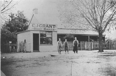 Bacchus Marsh & District Historical Society
Photograph, C.J. Grant, Bootmaker's Shop, corner of Grant Street and Waddell Street, Bacchus Marsh, circa 1907-1909
... C.J. Grant, Bootmaker's Shop, corner of Grant Street and... corner of Grant Street and Waddell Street in 1907. The business ...Charles Grant opened a boot makers business on the northern corner of Grant Street and Waddell Street in 1907. The business was advertised as being in Maddingley Road. By early 1910 the business had moved to 'Ryan's Corner' on the corner of Main Street and Gell Street, Bacchus Marsh. The brick house behind the boot maker's shop was built for Alexander Murdoch in 1869. It was used as a residence, a boarding house and as part of a business by a number of different owners over many years. It was known as the Murdoch house and also as 'Links Cottage' when it was used as a boarding house. For most of the twentieth century it was used as a residence. It was demolished in 1997 to make way for new residences.Black and white photograph print. A reproduction of an original photograph which is mounted on board. The image shows a boot maker's business and a brick house behind it. Standing in front of the shop on the footpath are three men wearing aprons.boot makers bacchus marsh victoria, shops bacchus marsh, houses bacchus marsh -
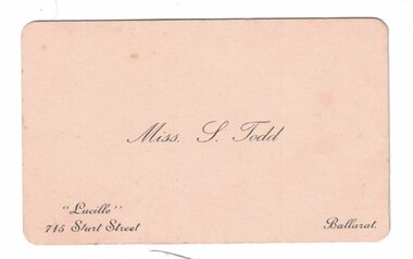 Linton and District Historical Society Inc
Business card, Miss S. Todd
Stella Todd (afterwards Mrs Geoffrey Surman), the youngest daughter of William and Lizzie Todd, became the proprietor of "Lucille" - a millinery shop in Ballarat.Small cream-coloured business card, silver printing, curved edges. Card inscribed "Miss S. Todd" across centre. "Lucille" / 745 Sturt Street" in smaller print in lower LH corner, "Ballarat" in smaller print in lower RH corner.Text, front: Miss. S. Todd. Handwritten on back: "With best wishes from: "Lucille" Girls"."lucille" milliner ballarat, stella todd, stella surman -
Canterbury History Group
Photograph - Wattle Valley Road view of Canterbury Mansions. Set of 5 photographs, Jan Pigot, 1994
Coloured photograph of the Wattle Valley Road view of the 3 storey Victorian Building called Canterbury Mansions. Also depicts the corner roof tower and the sold sign after the auction of the building.canterbury, canterbury mansions, shops, wattle valley road, signs, victorian architecture -
Canterbury History Group
Photograph - Old Timber House in Maling Road, Jan Pigot, 1992
Part of a set of 8 coloured photographs taken by Jan Pigot to record the demolition of some buildings in Maling Road to make way for new shops and car park.Old timber house on corner of Scott Street and Maling Road 1992. canterbury, maling road, timber house, scott street, shopping centres -
Canterbury History Group
Photograph - Street view of the corner of Maling Road and Bryson Street, Jan Pigot, 27/03/1993 12:00:00 AM
Coloured photograph of of the stage coach going down Maling Road taken from the Bryson Street corner.canterbury, maling road, shops, bryson street -
Canterbury History Group
Photograph - Street view of the western corner of Maling Road and Theatre Place, Jan Pigot, 27/03/1993 12:00:00 AM
Coloured photograph of the street view of the western corner of Maling Road and Theatre Placecanterbury, maling road, shops, theatre place -
Canterbury History Group
Photograph - Street view of the corner of Maling Road and Bryson Street depicting the shop No. 92. Maling Road, Jan Pigot, 1994
Coloured photograph of the street view of the corner of Maling Road and Bryson Street depicting Buckley's Supermarket at shop No. 92. Maling Road This is also the corner of the building named The Block 1907.canterbury, maling road, shops, bryson street, buckley family, the block -
Canterbury History Group
Photograph - Street view of the Bryson Road side of shop No. 92 Maling Road, Jan Pigot, 1994
Coloured photograph of the street view of the Bryson Road side of Buckley's Supermarket, shop No. 92 Maling Road. This is also the corner of the building named The Block 1907.canterbury, maling road, shops, bryson street, buckley family, the block -
Canterbury History Group
Photograph - Bryson Street view of the back of shop No. 92 Maling Road, Jan Pigot, 1994
Coloured photograph of the Bryson Street view of the back of Buckley's Supermarket at shop No. 92 Maling Road. This is also the corner of the building named The Block 1907.canterbury, maling road, shops, bryson street, the block, buckley family -
Canterbury History Group
Photograph - Streetscape of the corner of Bryson Street and Maling Road, Jan Pigot, 1994
Coloured photograph of the streetscape of the corner of Bryson Street and Maling Road. This is also the corner of the building named The Block 1907.canterbury, maling road, shops, bryson street, the block, buckley family -
Canterbury History Group
Photograph - Street view of shops on the corner of Canterbury Road and Balwyn Road, Jan Pigot, 1994
... . Photograph Street view of shops on the corner of Canterbury Road ...Coloured photograph of the street view of Carnell's Furniture shops at 173 Canterbury Road at the corner of Canterbury Road and Balwyn Road.canterbury, canterbury road, shops, balwyn road -
Canterbury History Group
Photograph - Interior of products for sale inside shop No. 111 Maling Road, Jan Pigot, 27/03/1993 12:00:00 AM
Coloured photograph of the interior of products for sale inside shop No. 111 Maling Road. Suzie Holcombe standing in one cornercanterbury, maling road, shops, holcombe family, shop interiors -
Canterbury History Group
Photograph - Canterbury Road view of the Canterbury Mansions at No. 208 Canterbury Road, Jan Pigot, 1994
Coloured photograph of the Canterbury Road view of the 3 storey Victorian Building called Canterbury Mansions. Also depicts the corner roof tower and the sold sign after the auction of the building.canterbury, canterbury road, shops, victorian architecture, signs