Showing 9252 items matching "tree"
-
 University of Melbourne, Burnley Campus Archives
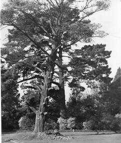
Photograph - Black and white print, Preparing Cypress for Felling, c. 1950
Note by T.H. Kneen 8 April 1992, "The tree was prepared for felling by Geo. Manley and Andy Tylee in the early 50's." (Also see B91.262.) This area is still known as the Cypress Bed.Black and white photograph. Large Cypress tree with lower limbs removed.geo. manley, andy tylee, cypress tree, cypress bed -
 Learmonth and District Historical Society Inc.
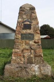
Addington photo, Addington Monument
This Monument was erected in1934,to commemorate the Centenary of the Addington district and its pioneering families. A memorial to the Aborigines in the form of a boomerang was at that time placed on a tree and later resited on the monument. Commemorating the Addington Pioneering families.A monument to commemorate the Centenary of Addington district,erected in memory of each pioneer family.A memorial in memory of the Aborigines in the Shape of a boomerang was placed on a tree at the same time. Over the years the tree died, the boomerang was resited and placed on the monument. (Boomerang)'' IN MEMORY OF THE BLACKS" (Plaque 1) " ERECTED BY A.J. BESELER IN 1994, RESITED BY LEARMONTH AND DISTRICT HISTORICAL SOCIETY UNVEILED ON 1-4-1990 BY Cr.A.R. McDONALD BALLARAT SHIRE PRESIDENT". (Plaque 2) " ERECTED TO THE MEMORY OF THE PIONEERS OF ADDINGTON 1934".1934, addington pioneer monument -
 Kiewa Valley Historical Society
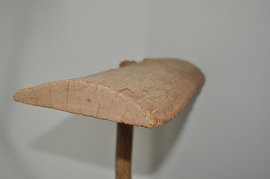
Squeegee - Tea Tree, circa mid to late 1900's
This "home made" squeegee was manufactured in the mid to late 1900's by an ingenuous dairyman as a solution to the removal of cow "pats" from the concrete floors of his "milking" sheds. The tea tree made squeegee (being made from nature's anti bacterial material) was an excellent hygienic implement to use. This "home made" wooden squeegee is very significant to the Kiewa Valley and its surrounding regions because it highlights the natural ingenuity found in the pioneer farmer, grazier and other rural folk. It demonstrates the "mother of invention and adaptation" is very strong in rural areas where "off the shelf" products were a rare quantity. Part of the natural psyche of the rural Australian inhabitants is the ability to produce inventions that overcome physical restrictive conditions, "the man/woman of all trades" is an apt description of the pioneers of yesteryear and of those to come.The squeegee handle is a long branch made from a tea tree, inserted into the upper flat side of a slab of tea tree wood which is flat on one side and curved on the other, the natural curve of the tree trunk. This squeegee was used on dairies for removing cow manure.timber, dairy, farm, rural, implement -
 Sunbury Family History and Heritage Society Inc.
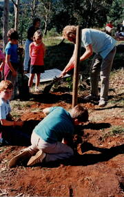
Photograph, Arbor Week celebration, 26th - 29th April 1989
The students along with the teachers at Bulla Primary School were celebrating Arbor Week in April 1989 by working in the school garden and planting more native trees in the surrounding area.The Arbor Week activities helped to give the children an appreciation of the environment and the importance of trees in our daily lives. A non-digital coloured photograph of six children and an adult planting trees in a gardenarbor, bulla primary school, tree planting, gardening -
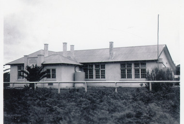 Lakes Entrance Historical Society
Photograph - Lakes Entrance State School, 1939
Young palm tree in front of schoolBlack and white photograph showing Lakes Entrance State School, Myer Street, with young palm tree in front of school. Lakes Entrance Victoriaschools, buildings -
 Stawell Historical Society Inc
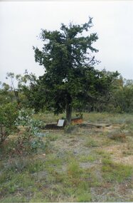
Photograph, Grave of John McClure
The Deep Lead Cemetery. The grave under the Cypress trees is that of John McClure B.A. who died in 1859 at the age of 46 years. He was the first clerk of petty sessions at Pleasant Creek and was one of the first buried at the deep lead cemetery which at the time was reserved but not fenced.Colour Photograph of a grave under cypress trees in bushlandGrave of John McClure at Deep Lead Cemetery -
 Stawell Historical Society Inc
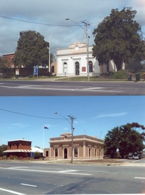
Photograph, Stawell Shire Hall -- Before and After colour photos of the Shire Hall, one photograph taken in 2011
Two Stawell Shire Hall colour photos showing the changes over time to the landscape around the Shire building. In 2011 the two Norfolk Island hibiscus trees were removed. In the photo with the trees removed the building is painted a brown colour and has the Australian flag flying on the flag post. Two colour photographs of Stawell Shire Hall showing how the landscape around the building has changed over time. In 2011 the Norfolk Island Hibiscus trees were removed. The building was painted white in one photo and when the trees removed painted a brown colour similar to the initial brick of the building. stawell -
 Robin Boyd Foundation
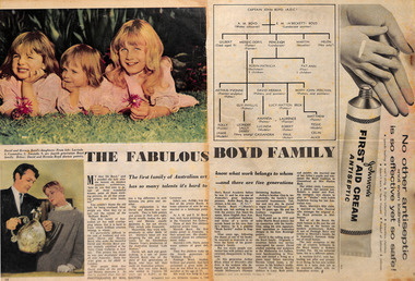
Magazine - Clipping, Woman's Day with Woman, The Fabulous Boyd Family, 06.10.1958
A short portrait, including family tree, of the Boyd family, starting with Captain John Boyd (A.D.C), Robin Boyd's grandfather.Double page spread on pp 14-15, with family tree and photographs of David and Hernia Boyd and their children.walsh st library -
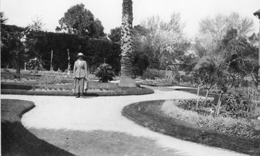
 Ballarat Heritage Services
Photograph - Photograph - Colour, Clare Gervasoni, Wombat Botanic Gardens, Daylesford, 2019, 23/04/2019
The Daylesford Botanic Gardens are of historic, scientific (botanic), and aesthetic significance to the State of Victoria. The Daylesford Botanic Gardens are historically significant as a fine example of a regional botanic garden demonstrating the typical characteristics of a carriage drive, informal park layout, decorative structures and works such as the memorial tower, conservatory, rotunda, cascade and fernery, which contrasts with the open lawns planted with specimen trees, areas of intensive horticultural interest and close proximity to a township developed during the mid to late nineteenth century. The Daylesford Botanic Gardens are historically significant for the design input by noted landscape designer William Sangster, and for the survival of his 1884 plan, which is a rare example of a plan from this prolific garden designer. The Daylesford Botanic Gardens are of scientific (botanic) significance for the extensive conifer collection and cool climate plants. The Gardens contain an outstanding collection of conifers and other mature trees, many of which were donated by renowned botanist Ferdinand von Mueller. Significant trees include Pinus ponderosa (Western Yellow Pine), Pinus coulteri (Big Cone Pine), twoAbies nordmanniana (Caucasian Fir), Abies pinsapo, (Spanish Fir) and a Cedrus atlantica f. glauca(Blue Atlas Cedar), Pinus wallichiana (Bhutan Pine), Pinus pinaster (Maritime Pine), Sequoiadendron giganteum (Giant Redwood), (Monkey Puzzle) and Aesculus hippocastanum (Horse Chestnut), many the largest or finest examples in Victoria. Other outstanding trees include a Tilia cordata (Small-leaved European Linden), a row of Cupressus lusitanica (Mexican cypress), a Quercus robur (English Oak) planted in 1863, avenues of Dutch Elms and a rare Quercus leucotrichophora (Himalayan Oak). The Daylesford Botanic Gardens are of aesthetic significance as a rare example of a botanic garden spectacularly sited on an extinct volcanic cone which allows a panoramic view, aided by the 1938 Pioneers’ Memorial Tower, as well as vistas within and out of the gardens and from the township to the gardens. As the most prominent local landmark, the Garden’s vertical dominance in the landscape provides a dark contrast to the elms avenues, oaks and other deciduous species. (Heritage Victoria Register, 2025)An avenue of trees in the Wombat Hill Gardens. wombat botanical gardens, daylesford botanical gardens, daylesford, trees -
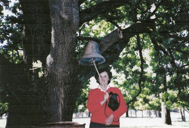 Stawell Historical Society Inc
Photograph, Ledcourt Bell Cooper Family Photos
Fay Newton nee Cooper ringing a large bell in a tree at Ledcourt StationColour print of woman in a red top holding a black bag and ringing a bell in right hand that is hanging from a large tree. Fay Newton nee Cooperstawell -
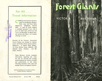 Marysville & District Historical Society
Ephemera (Item) - Information brochure, Victorian Government Tourist Bureau, Forest Giants Victoria Australia, 01-1938
An information brochure on where to see tall trees, Forest Giants, in Victoria, including Marysville, that was published in January, 1938.An information brochure on where to see tall trees, Forest Giants, in Victoria, including Marysville, that was published in January, 1938.Victorian Railways Print January, 1938 469-38 Stamp of Victorian/ Government Tourist Bureau/ 272 Collins Street/ Melbourne C.1victoria, australia, victorian government tourist bureau, betterment and publicity board, victorian railways, white mountain ash, red mountain ash, messmate, blue gum, mountain ash, cumberland valley, marysville, mount monda, healesville, acheron way, alpine highway, omeo, baw baws, strzelecki ranges, otway ranges, warburton, yarra junction, noojee, bulga and tarra valley park, yarram, turton's pass, otway forest, beech forest, apollo bay, information brochure, brochure -
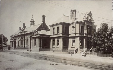 Kew Historical Society Inc
Postcard, Post Office and Police Court Kew, 1907-1915
The Kew Historical Society's postcard collection includes views of Kew, Melbourne and Greater Melbourne as well as those including overseas scenes sent or received from Europe or the Middle East. They date from the 1890s to the 2000s. These postcards may or may not include the name of the publisher or printer. A number of the cards were published as parts of popular series. A way of dating early postcards is to identify whether the reverse was divided by a central line which became the norm after 1902 in the United Kingdom. However, other postcards produced after this date do not always conform to this print layout.The item forms part of the Laurie Bennett collection of thirty-six postcards and photographs of Kew and early Melbourne, donated to the Kew Historical Society in 1980. The postcards in the Bennett collection, like other images in the Society's holdings date from the 1890s to the present and comprehensively indicate points-of-view or scenes considered historically, aesthetically or socially significant in the period in which they were produced.Postcard depicting the Kew Post Office and Court House (built 1888) on the corner of High Street and Cotham Road. In front of the Post Office is a large Moreton Bay Fig tree. The later Kew War Memorial (opened 1925) necessitated the removal of the tree and the relaocation of the Queen Victoria Jubilee Fountain. "No-KH-388. 1888. Donated by Mr. L. Bennett. Later buildings joined. Fig tree + Queen Victoria Jubilee Fountain moved to make way for World War I Memorial 1920."kew court house, kew post office, postcards -
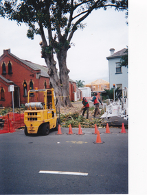 Port Melbourne Historical & Preservation Society
Photograph - Destruction of Port Jackson fig tree, Holy Triniy Anglican Church, Port Melbourne, Pat Grainger, 7 Dec 1999
Removal of the tree was surreptitiously begun and so was partially done before the community realised. It took several days, for as contrary to the claims of the vicar, the tree was extremely healthy. One of 21 colour photographs showing the destruction of the Port Jackson fig tree which stood in the grounds of the Holy Trinity church until December 1999. (Ref item 1637)demolitions, religion - anglican (holy trinity) -
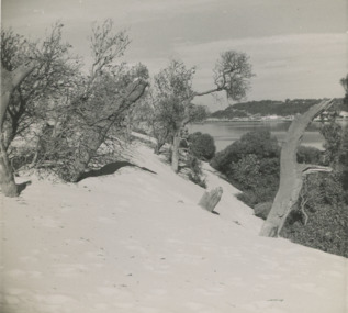 Lakes Entrance Historical Society
Photograph - Sand hummocks c1952 Lakes Entrance Victoria, L Carpenter, 1952 c
sand hummocks showing drifting sand overwhelming a stand of coastal banksia trees.Black and white photograph of sand hummocks showing drifting sand overwhelming a stand of coastal banksia trees. Part of western end of township across Cunninghame Arm in distance Lakes Entrance Victoria. Also three black and white photographs showing sandrifts on hummocks overwhelming coastal banksia trees and other vegetation . c1952sand dunes, vegetation, environment -
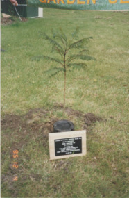 Lakes Entrance Historical Society
Photograph - Garden club, 1995
tree donated by Brian Hancock, planted by Peter Nixon East Gippsland Shire CommissionerColour photograph jacaranda tree planted at the Aquadome to celebrate the 25th birthday of the Garden Club with a plaque beside it. Lakes Entrance Victoriaclubs, celebrations -
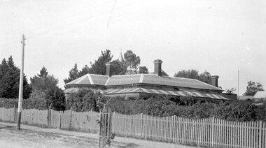 Surrey Hills Historical Society Collection
Photograph, Ken Hall, Victorian home at 215 Union Road, Surrey Hills, Original: 1920; copy by Ken Hall: 1980s
Built in 1888, which was 5 years before water reticulation came to Surrey Hills. It originally relied on rainwater and a well (still in existence in 2009) was located near the back door. From 1921 this was the home of Mr Natale and Mrs Ethel May Cerini and their family. It remained in the family until it was sold in May 2015. The Cerinis had 2 daughters - Jocelyn Francesca and Lynette Lorraine . The house passed to Jocelyn after her parents' deaths. Mr Cerini named the house after a property in NSW called 'Goonoogoonoo' where he had worked. It had been named 'Montiere' at a previous time. Natale was an accountant and very active in community affairs, especially after his retirement. The house was originally on a double block. [Additional information: Ken Hall - 2/12/2009] The first owner was A Embling, followed by Mrs L A Campbell. [Ref: Alan Holt property register] A Embling was most likely Austin Henry Chinnock Embling (1867, Ballarat East - 2 OCT 1900), eldest son of Dr Dr William and Elizabeth Embling (née Austin). His wife was Sybil Mary Mildred (MS: Edlin), born in Adelaide, whom Austin Embling married in 1898. Black and white photo of a Victorian style house with 3 brick chimneys, a slated roof and a verandah on 2 sides. It has iron lacework and the roof is striped corrugated iron. It sits behind a picket fence. The spire of Surrey College can be seen behind the trees at the rear of the house. In the street is an electric light pole and an immature tree within a picket protection guard.Paper type-written tags mounted at the bottom of the photo - LHS: " Built 1888"; RHS: "215 Union Road in 1920 / Surrey College can be / seen behind the trees."houses, victorian style, goonoogoonoo, surrey college, street trees, natale cerini, kenneth tudor hall, ken hall, jocelyn cerini, jocelyn hall, ethel may swan, ethel swan, ethel cerini, jocelyn francesca cerini, natale benjamin cerini, natale benjamin john andrea cerini, ethel may cerini, lynette lorraine cerini, lynette lorraine lazarus, austin embling, austin henry chinnock embling, sybil mary embling, sybil mary edlin, sybil mary mildred, montiere, goonoo goonoo, lynette cerini -
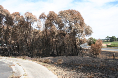 Sunbury Family History and Heritage Society Inc.
Photograph, Rosa McCall, February 2014
The cluster of trees beside the Calder Highway, north of Sunbury, were burnt in February 2014 when a grassfire started along the road and a severe wind change from the south took the flames across the dry countryside beyond Riddells Creek and beyond Clarkefield. The Bendigo rail line was damaged resulting in it being closed for repairs. This was one of the many fires experienced over that hot summer when the countryside was parched.A coloured digital photograph of a cluster of burnt trees by a roadsidegrassfires, calder highway, riddells creek -
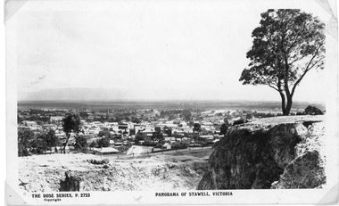 Stawell Historical Society Inc
Photograph, Panorama of Stawell from Big Hill c 1920's
Panorama of Stawell from Big Hill. Open Cut in foreground, tree on right. Grampians in background. The Rose Series. P. 2723Black & white photograph depicting a Panorama of Stawell town. The image shows a large tree on the right above a cutting. The Rose Series, P 2723 copyright. Panorama of Stawell Victoria on the front. On the back "The Rose Series De Luxe" Published by The Rose Stereograph Armidale, Victoriastawell, panorama -
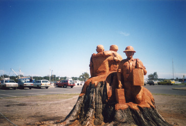
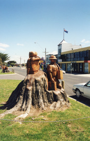 Lakes Entrance Historical Society
Photograph - Memorial Carvings by John Brady, 1999c
sculptures carved from WW1 Memorial Avenue cypress trees, by John Brady, Lakes Entrance Victoria c1999Colour photograph of sculptures carved from WW1 Memorial Avenue cypress trees, by John Brady, Lakes Entrance Victoriaworld war 1914-1918, memorials -
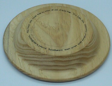 Ringwood RSL Sub-Branch
Commerative object, Lone Pine Bowl, 2017
The wood from which the bowl was turned came from the original Lone Pine Tree that stood by the Shrine of Remembrance in Melbourne for many years.A round bowl made from pine wood. Details around the bottom. "The Lone Pine Gallipoli produced seeds which were subsequently planted in Australia. This bowel was made from the wood of one of those trees" -
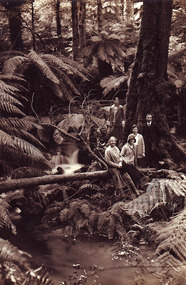 Marysville & District Historical Society
Photograph (item) - Black and white photograph, Unknown
A digital copy of an early black and white photograph of a group of five people standing next to a large tree at the base of a waterfall.a digital copy of an early black and white photograph of a group of five people standing next to a large tree at the base of a waterfall.waterfall -
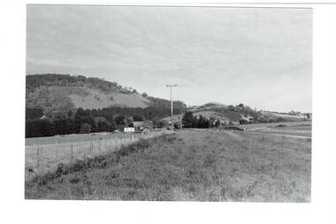 Buninyong & District Historical Society
Photograph - B/W photograph, Mr. Clive J. Brooks, North Eastern slopes of Mount Buninyong from Yendon Road, April 1994
Tree cover on Mount Buninyong and agricultural use of land in 1994 clearly visible.Natural and agricultural record of Mount Buninyong in late 20th centuryBlack and white photograph of the North Eastern slopes of Mount Buninyong from Yendon No. 1 Road. Tree cover and agriculture use clearly visible.mount buninyong, landscape -
 Stawell Historical Society Inc
Photograph, Central Park Gardens, c 1920's
Central Park Gardens. Lady beside mature palm tree with hedge in background. c1920'sBlack & white photograph of Central Park gardens with woman standing on path beside garden bed with truck of palm tree in center of photo.stawell -
 Lakes Entrance Historical Society
Photograph - Memorial Carvings by John Brady, 1999
sculptures carved from WW1 Memorial Avenue cypress trees, by John Brady c1999 Lakes Entrance VictoriaColour photograph of sculptures carved from WW1 Memorial Avenue cypress trees, by John Brady c1999 Lakes Entrance Victoriaworld war 1914-1918, memorials -
 Lakes Entrance Historical Society
Photograph - Memorial Carvings by John Brady, 1999c
sculptures carved from WW1 Memorial Avenue cypress trees by John Brady c1999 Lakes Entrance VictoriaColour photograph of sculptures carved from WW1 Memorial Avenue cypress trees by John Brady c1999 Lakes Entrance Victoriaworld war 1914-1918, memorials -
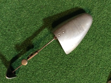 Yarrawonga and Mulwala Pioneer Museum
Shoe Trees
2 shoe trees - not a pair. Aluminium shape which slides into toe of shoe Metal stem attached which has holes for length adjustment1.Registered trade mark Lenards for good boots and shoes 9 1/2 x 10m 2. Saxone deluxe shoe tree 9 1/2 x 11 -
 Stawell Historical Society Inc
Photograph - Collection of Photos, Fisher Street: Family circa end of WW1
End of WW1 1917 -1918 - Family lived in Fisher Street. copies of 18 B/W Photos taken in yard near fence line of Path some have Peppercorn Tree. Family with pet dogs. Most men have Poppy on lapels. Geoff Bullock purchased Glass Slide Photos in garage sale in Fisher Street Stawell in early 2000'sA Male in Soldiers unofrom under a tree with a house in the Background. -
 Phillip Island and District Historical Society Inc.
Photograph, circa 1900
Strip of water shore with a dingy close to water and larger boat to the right. San Remo Hotel and Griffiths Store nestled in among large bushy trees. Behind the rather ornate hotel a glimpse of a rising bare hill.San Remo shore with glimpse of San Remo Hotel amongst trees beyond the beach.San Remo Shore 251local history, photography, photographs, slides, film, san remo shore, black & white photograph, miss elms san remo -
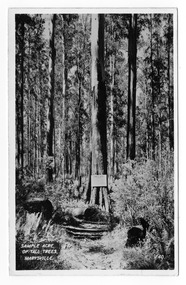
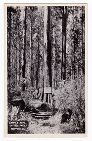 Marysville & District Historical Society
Postcard (item) - Black and white postcard, Valentine Publishing Co. Pty. Ltd, Sample Acre of Tall Trees, Marysville. V. 40, 1923-1963
An early black and white photograph of a sample acre of tall trees near Marysville in Victoria.An early black and white photograph of a sample acre of tall trees near Marysville in Victoria. After the devastating 1939 ‘Black Friday’ bushfires, Victoria’s tallest known trees were to be found in the Cumberland scenic reserve, 20 km north-east of Marysville. This stand of trees was set aside in the 1920s to preserve a ‘sample acre’ of tall trees. It originally contained 27 trees, the tallest of which was said to be 92 m, whilst the average height was 81 m. A severe wind storm in 1959 blew down 13 trees and left the ‘tall tree’ at a reduced 84 m (Munro 1992). An examination of the crown of this tree by arborist Tom Greenwood (Tom Greenwood pers. comm. 2001) suggested that it was unlikely that it ever reached the original figure of 92 m; the current height is 81.5 m, a figure used as the starting point for this search for Victoria’s tallest trees. This postcard was published by the Valentine Publishing Co. Pty. Ltd. as a souvenir of Marysville.VALENTINE'S/ POST CARD/ A GENUINE PHOTOGRAPHsample acre, tall trees, marysville, victoria, cumberland valley, postcard, valentine publishing co, souvenir, 1939 bushfires, cumberland scenic reserve -
 Marysville & District Historical Society
Postcard (item) - Black and white postcard, Valentine Publishing Co. Pty. Ltd, Sample Acre of Tall Trees, Marysville. V. 40, 1923-1963
An early black and white photograph of a sample acre of tall trees near Marysville in Victoria.An early black and white photograph of a sample acre of tall trees near Marysville in Victoria. After the devastating 1939 ‘Black Friday’ bushfires, Victoria’s tallest known trees were to be found in the Cumberland scenic reserve, 20 km north-east of Marysville. This stand of trees was set aside in the 1920s to preserve a ‘sample acre’ of tall trees. It originally contained 27 trees, the tallest of which was said to be 92 m, whilst the average height was 81 m. A severe wind storm in 1959 blew down 13 trees and left the ‘tall tree’ at a reduced 84 m (Munro 1992). An examination of the crown of this tree by arborist Tom Greenwood (Tom Greenwood pers. comm. 2001) suggested that it was unlikely that it ever reached the original figure of 92 m; the current height is 81.5 m, a figure used as the starting point for this search for Victoria’s tallest trees. This postcard was published by the Valentine Publishing Co. Pty. Ltd. as a souvenir of Marysville.VALENTINE'S POST CARD A GENUINE PHOTOGRAPHsample acre, tall trees, marysville, victoria, cumberland valley, postcard, valentine publishing co, souvenir, 1939 bushfires, cumberland scenic reserve