Showing 1028 items matching "water river"
-
 Bayside Gallery - Bayside City Council Art & Heritage Collection
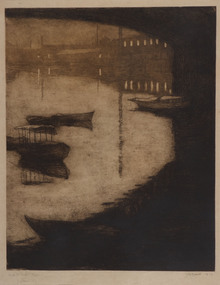
Print - etching, Jessie Constance Alicia Traill, Under the bridge, 1912
etchingbridge, boats, reflection, water, etching, print, jessie traill, melbourne, yarra, river -
 Bendigo Historical Society Inc.
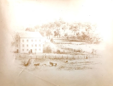
Photograph - Glass Slide Photos of Bendigo, Early 1900s
Bendigo followed much the same pattern as Ballarat, and was not ready for an up-to-date studio until 1880 when the Bartlett Bros. (Francis and Henry) who bad conducted a successful business in Melbourne for many years opened a small studio there. It was such a success that they decided to build large modern premises, and Francis made two trips to England and the Continent for the latest ideas. In 1884 Henry died, and to replace him, Francis secured the services of Robert W. Bugg, then employed by Foster & Martin (both pupils of Batchelder's) in Collins Street, Melbourne. In that studio Bugg made some fine portraits of Anthony Trollope during the novelist's long tour of Australia. Francis Bartlett was a keen business man, and Robert Bugg was a great operator and a fine painter. Together, their success was quite outstanding. Fifteen years later Bartlett retired with a fortune, and Bugg took over the studio. Robert William Bugg, one of our leading Painter-Photographers, was born in London in 1853, and came to Melbourne when he was five years old. He became a pupil of Louis Buvelot and, in 1879, a member of the Victorian Academy of Arts. In Bendigo he gave annual exhibitions of his oils and water colours, a number of his exhibitions being officially opened by his friend Alfred Deakin. There are a number of Bugg's Paintings in the Bendigo Art Gallery. All the portraits, landscapes, buildings, and city views illustrated in "Bendigo and Vicinity, 1897", are from photographs taken by Robert Bugg. He was a clever, genial and popular soul, and his influence on the cultural life of his adopted city was considerable. He retired in 1932 and died in his early eighties.Eleven Photos of Bendigo from Glass Plate Negatives, Campaspe River at Axedale, Axe Creek, Lake Weroona, White Hills Botanical Gardens, Conseratory Gardens, Bendigo Fernery. Slides are ex Bartlett Brother Bendigo. history, bendigo, bendigo conservatory gardens, campaspe river axedale, axe creek victoria, lake weroona bendigo, white hills botanical gardens bendigo, bartlett brothers bendigo, rosalind park bendigo -
 Bendigo Historical Society Inc.
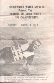
Pamphlet - Aileen and John Ellison Collection: Bridgewater water ski club
... Established in 1960 on the Loddon River, the Bridgewater... Established in 1960 on the Loddon River, the Bridgewater Water ski ...Established in 1960 on the Loddon River, the Bridgewater Water ski Club includes a general skiing area, a slalom course and a jumps course.Small pamphlet. Bridgewater water ski club present the Central Victorian water ski championships. Sunday March 4, 1973. on the front cover a male water skier and, on the back, a female one. The pamphlet lists the various categories and the names of the competitors. bridgewater, water ski club -
 Bendigo Historical Society Inc.
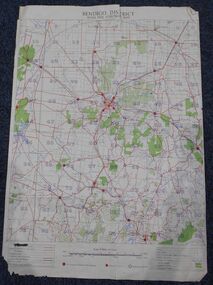
Map - Bush Fire Control Map Bendigo District
... , telephone lines, rivers, creeks and water courses. Also marked... roads, railway lines, telephone lines, rivers, creeks and water ...A Bush Fire Control map is a valuable tool used by emergency services and communities to respond to respond to bushfires.Cream coloured parchment map showing roads, railway lines, telephone lines, rivers, creeks and water courses. Also marked are houses, Post Offices, Police stations, bush fire brigades, water channels, swamps, marshes, dense, medium and scattered timber, aqueducts and reservoirs. Villages, districts and Towns are clearly marked. Printed in red, green, black and blue. Very clear and easy to read. Undated.bush fires, bendigo area map -
 Kew Historical Society Inc
Photograph, Marnie McLeod, Floods of the River Yarra at Kew, 1916
The donation was accompanied by the following letter from the donor: "Hi. I found these in with family photos. Taken by family as Mamie McLeod was living in Fellows Street, Kew, so would be near there. Retain (or discard) as you see fit." [Donor's name and address withheld from public view]. To gain an insight into the flood levels at Kew, it is worth reading newspaper accounts of the event. The Age published an article - Valuable Gardens Destroyed at Kew - on 25 September 1916: "VALUABLE GARDENS DESTROYED AT KEW. From the heights of Studley Park, Kew, a splendid view of the flood waters can be obtained, and yesterday afternoon, despite continuous rain, crowds of citizens assembled there to witness the spectacle. There is a vast stretch of water some 300 or 400 yards broad, above the foot bridge connecting Gipps-street, Collingwood, and Studley Park. The river is only about 3 feet from the top of the embankment connecting with the ramp of the bridge on the Studiey Park side. When the upper llood waters come down it is almost a certainty that tne embankment will be submerged and the bridge rendered impassible. Below the bridge the waters again stretch out, and have submerged all the low-lying land on the Collingwood side and invaded the back premises ot the Kodak Co., Phoenix Biscuit Factory, a tannery adjoining thereto, the Shamrock Brewery, and Chinese gardens in the vicinity. At Walmer-street-bridge, at the end of Studley Park, the low-lying land on the Kew side is covered with water to the depth of many feet. Tlie land in question is owned in a great part by Mr Frank Lavers who haa gone in for intense culture on a pretty liberal scale on both the slopes of the hill and on the river flat. On the latter he is cultivating many acres of asparagus, and has at a considerable cost spent three years in preparing the ground and installing an irrigation system, reticulated from the Yan Yean water supply. This year the asparagus was put down, and the plants were in a promising condition. Tlie flood waters are now flowing fast over the land. The crop is ruined, and three years' work and expenditure destroyed. Mr. Laver's private residence fortunately is high above flood level, but two houses he owns off Young-street have been flooded out. Having been warned in time, the tenants removed their furniture hefore the water came down to Mr. Laver's residence, where they themselves have been given accommodation in the meantime. All the river flats in East Kew are under water. One or two low-lying houses have been flooded. Chipperfield's boat shed at Willsmere is nearly covered, and some Chinese gardens in the vicinity are several feet under water."This, and the other three photographs donated of floods in Kew are believed to be the earliest in the collection. Together with our original MMBW River Yarra map showing flood levels, these items, when compared allow researchers to gain a visual perspective of the extent of the flood in 1916. Black and white photograph of flooded trees in Kew with rising dry ground in distance.Inscription on reverse in pencil: "Flood River Yarra Kew Vic"river yarra, kew, floods 1916 -
 Kew Historical Society Inc
Photograph, Marnie McLeod, Floods on the River Yarra at Kew, 1916
The donation was accompanied by the following letter from the donor: "Hi. I found these in with family photos. Taken by family as Mamie McLeod was living in Fellows Street, Kew, so would be near there. Retain (or discard) as you see fit." [Donor's name and address withheld from public view]. To gain an insight into the flood levels at Kew, it is worth reading newspaper accounts of the event. The Age published an article - Valuable Gardens Destroyed at Kew - on 25 September 1916: "VALUABLE GARDENS DESTROYED AT KEW. From the heights of Studley Park, Kew, a splendid view of the flood waters can be obtained, and yesterday afternoon, despite continuous rain, crowds of citizens assembled there to witness the spectacle. There is a vast stretch of water some 300 or 400 yards broad, above the foot bridge connecting Gipps-street, Collingwood, and Studley Park. The river is only about 3 feet from the top of the embankment connecting with the ramp of the bridge on the Studiey Park side. When the upper llood waters come down it is almost a certainty that tne embankment will be submerged and the bridge rendered impassible. Below the bridge the waters again stretch out, and have submerged all the low-lying land on the Collingwood side and invaded the back premises ot the Kodak Co., Phoenix Biscuit Factory, a tannery adjoining thereto, the Shamrock Brewery, and Chinese gardens in the vicinity. At Walmer-street-bridge, at the end of Studley Park, the low-lying land on the Kew side is covered with water to the depth of many feet. Tlie land in question is owned in a great part by Mr Frank Lavers who haa gone in for intense culture on a pretty liberal scale on both the slopes of the hill and on the river flat. On the latter he is cultivating many acres of asparagus, and has at a considerable cost spent three years in preparing the ground and installing an irrigation system, reticulated from the Yan Yean water supply. This year the asparagus was put down, and the plants were in a promising condition. Tlie flood waters are now flowing fast over the land. The crop is ruined, and three years' work and expenditure destroyed. Mr. Laver's private residence fortunately is high above flood level, but two houses he owns off Young-street have been flooded out. Having been warned in time, the tenants removed their furniture hefore the water came down to Mr. Laver's residence, where they themselves have been given accommodation in the meantime. All the river flats in East Kew are under water. One or two low-lying houses have been flooded. Chipperfield's boat shed at Willsmere is nearly covered, and some Chinese gardens in the vicinity are several feet under water."This, and the other three photographs donated of floods in Kew are believed to be the earliest in the collection. Together with our original MMBW River Yarra map showing flood levels, these items, when compared allow researchers to gain a visual perspective of the extent of the flood in 1916. Panoramic view, believed to be looking north towards Fairfield from the Zig-Zag Bridge on the River Yarra. The inscription on the reverese identifies it as taken before 1920.Inscription on reverse in ink "(pre 1920) Flood from Zig-zag bridge Yarra River, Kew Vic."river yarra, kew, floods 1916, zig-zag bridge -
 Kew Historical Society Inc
Photograph, Marnie McLeod, Flood, River Yarra, Kew, 1916
The donation was accompanied by the following letter from the donor: "Hi. I found these in with family photos. Taken by family as Mamie McLeod was living in Fellows Street, Kew, so would be near there. Retain (or discard) as you see fit." [Donor's name and address withheld from public view]. To gain an insight into the flood levels at Kew, it is worth reading newspaper accounts of the event. The Age published an article - Valuable Gardens Destroyed at Kew - on 25 September 1916: "VALUABLE GARDENS DESTROYED AT KEW. From the heights of Studley Park, Kew, a splendid view of the flood waters can be obtained, and yesterday afternoon, despite continuous rain, crowds of citizens assembled there to witness the spectacle. There is a vast stretch of water some 300 or 400 yards broad, above the foot bridge connecting Gipps-street, Collingwood, and Studley Park. The river is only about 3 feet from the top of the embankment connecting with the ramp of the bridge on the Studiey Park side. When the upper llood waters come down it is almost a certainty that tne embankment will be submerged and the bridge rendered impassible. Below the bridge the waters again stretch out, and have submerged all the low-lying land on the Collingwood side and invaded the back premises ot the Kodak Co., Phoenix Biscuit Factory, a tannery adjoining thereto, the Shamrock Brewery, and Chinese gardens in the vicinity. At Walmer-street-bridge, at the end of Studley Park, the low-lying land on the Kew side is covered with water to the depth of many feet. Tlie land in question is owned in a great part by Mr Frank Lavers who haa gone in for intense culture on a pretty liberal scale on both the slopes of the hill and on the river flat. On the latter he is cultivating many acres of asparagus, and has at a considerable cost spent three years in preparing the ground and installing an irrigation system, reticulated from the Yan Yean water supply. This year the asparagus was put down, and the plants were in a promising condition. Tlie flood waters are now flowing fast over the land. The crop is ruined, and three years' work and expenditure destroyed. Mr. Laver's private residence fortunately is high above flood level, but two houses he owns off Young-street have been flooded out. Having been warned in time, the tenants removed their furniture hefore the water came down to Mr. Laver's residence, where they themselves have been given accommodation in the meantime. All the river flats in East Kew are under water. One or two low-lying houses have been flooded. Chipperfield's boat shed at Willsmere is nearly covered, and some Chinese gardens in the vicinity are several feet under water."This, and the other three photographs donated of floods in Kew are believed to be the earliest in the collection. Together with our original MMBW River Yarra map showing flood levels, these items, when compared allow researchers to gain a visual perspective of the extent of the flood in 1916. Small black and white photograph of flooded trees in Kew.Inscription on reverse in ink "Flood R. Yarra Kew Vicriver yarra, kew, floods 1916 -
 Kew Historical Society Inc
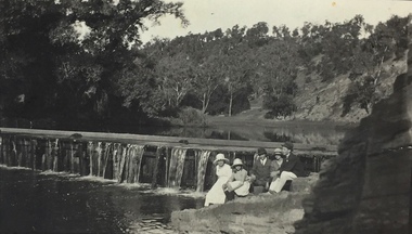
Photograph, Richardson Family at Dight's Falls, 1920
... on the Kew side of the river, which pumped water uphill... on the Kew side of the river, which pumped water uphill ...Dight’s Falls in Studley Park is an artificial weir built on a natural rock bar across the Yarra. The weir was built in the 1840s to provide water to the ‘Ceres’ flour-mill, one of the first in Victoria. The falls were later to become known as Dight’s Falls after the owners of the mill. Later, a pumping station was built on the Kew side of the river, which pumped water uphill to a reservoir in Walmer Street that provided water to the Melbourne Botanical Gardens and to Albert Park Lake. The area around Dight’s Falls was and is frequently used for recreational activities.This photograph forms part of the collection assembled by the historian Dorothy Rogers, that was donated to the Kew Historical Society by her son John Rogers in 2015. The manuscripts, photographs, maps, and documents were sourced by her from both family and local collections or produced as references for her print publications. Many were directly used by Rogers in writing ‘Lovely Old Homes of Kew’ (1961) and 'A History of Kew' (1973), or the numerous articles on local history that she produced for suburban newspapers. Most of the photographs in the collection include detailed annotations in her hand. The Rogers Collection provides a comprehensive insight into the working habits of a historian in the 1960s and 1970s. Together it forms the largest privately-donated collection within the archives of the Kew Historical Society.Black and white photograph of the Richardson family seated on the Kew side of Dight's Falls in 1920. One of the girls in the photograph was to become the Melbourne historian Dorothy (Richardson) Rogers.Annotation on reverse: "Mrs D. Rogers, 29 Park Crst Kew. Dights Falls 1920"dight's falls - kew (vic) - fairfield (vic), sport and recreation - kew (vic), dorothy rogers -
 Kew Historical Society Inc
Photograph, J F C Farquhar, Dight's Falls, 1891
At the beginning of the 1890s, the Kew businessman and Town Councillor, Henry Kellett, commissioned J.F.C. Farquhar to photograph scenes of Kew. These scenes included panoramas as well as pastoral scenes. The resulting set of twelve photographs was assembled in an album, Kew Where We Live, from which customers could select images for purchase.The preamble to the album describes that the photographs used the ‘argentic bromide’ process, now more commonly known as the gelatine silver process. This form of dry plate photography allowed for the negatives to be kept for weeks before processing, hence its value in landscape photography. The resulting images were considered to be finely grained and everlasting. Evidence of the success of Henry Kellett’s venture can be seen today, in that some of the photographs are held in national collections.It is believed that the Kew Historical Society’s copy of the Kellett album is unique and that the photographs in the book were the first copies taken from the original plates. It is the first and most important series of images produced about Kew. The individual images have proved essential in identifying buildings and places of heritage value in the district.Dight’s Falls in Studley Park is an artificial weir built on a natural rock bar across the Yarra. The weir was built in the 1840s to provide water to the ‘Ceres’ flour mill, one of the earliest industrial sites in Melbourne. The falls were later to be named after the owner of this mill. In 1888, William Guilfoyle, Director of the Melbourne Botanical Gardens had called for fresh water to be piped from above the weir to the Botanical Gardens, using a pumping station on the Kew side of the Falls, a holding reservoir in Walmer Street and a series of pipes from there to the Gardens. This system was opened in May 1891. Farquhar’s photograph of the man-made weir obscures the industrial activity on both sides of the Falls and focusses solely on the river and the surrounding natural vegetation. The photograph probably predates the disastrous flooding of the Yarra River in July 1891, the greatest to have occurred in the Colony since the foundation of Melbourne.Dight's Fallskew illustrated, kew where we live, photographic books, henry kellett, yarra river -
 Kew Historical Society Inc
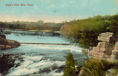
Postcard - Dight's Falls, River Yarra, c.1911
... on the Kew side of the river, which pumped water uphill... on the Kew side of the river, which pumped water uphill ...Dight’s Falls in Studley Park is an artificial weir built on a natural rock bar across the Yarra. The weir was built in the 1840s to provide water to the ‘Ceres’ flour-mill, one of the first in Victoria. The falls were later to become known as Dight’s Falls after the owners of the mill. Later, a pumping station was built on the Kew side of the river, which pumped water uphill to a reservoir in Walmer Street that provided water to the Melbourne Botanical Gardens and to Albert Park Lake. The area around Dight’s Falls was and is frequently used for recreational activities.Dated postcard allowing one to analyse the form of the Falls in 1911Colour postcard, of Dight's Falls on the River Yarra between Kew and Fairfield. The photograph is taken looking upstream towards the Falls from the Kew side, from the embankment in the vicinity of the Pumping Station. Obverse: "Dight's falls, Kew" Reverse: "Printed in Great Britain Writing in ink on Reverse: "31/3/1911 / To dear Nell with best wishes for a happy birthday from your old friend Eve / [Addressed to] "Mrs N Dunn, Prahran" Franked Victorian 1d stamp on Reverse top rightdight's falls, dight's falls - kew (vic) - fairfield (vic) -
 Kew Historical Society Inc
Print - Walmer Street Foot Bridge
A bridge to Walmer Street, Kew, from Abbotsford was located at the northern end of Burnley Street. It was a foot bridge.Photographic print of the Walmer Street Bridge. The view of the Bridge is from the Abbotsford side of the Yarra. A section of pipe on the near side of the bridge is a remnant of the irrigation pipes that carried water from above Dight's falls to the Melbourne Botanic Gardens. The former bridge, constructed in 1896 was swept away in the 1901 Flood. It has two major brick piers while the remainder of the trestle supports are metal. The original photograph from which this copy was made was taken after 1901 as it shows the second bridge under construction. Houses in Young Street, Kew, can be seen on the far side of the river.Written on reverse: "Walmer St. Bridge. Erected 1896. Being rebuilt after 1901 flood damaged it. Houses on left are in Young St."bridges -- kew (vic.), walmer street bridge, melbourne botanic gardens -
 Kew Historical Society Inc
Print - Walmer Street Foot Bridge, 1901
Photographic print of the Walmer Street Bridge. The view of the Bridge is from the Abbotsford side of the Yarra. A section of pipe on the near side of the bridge is a remnant of the irrigation pipes that carried water from above Dight's falls to the Melbourne Botanic Gardens. The former bridge, constructed in 1896 was swept away in the 1901 Flood. It has two major brick piers while the remainder of the trestle supports are metal. The original photograph from which this copy was made was taken after 1901 as it shows the second bridge under construction. Houses in Young Street, Kew, can be seen on the far side of the river.Reverse: " Walmer St footbridge 1901 being repaired after flood / Constructed 1892 substantially renewed in 1901 and in 1928 / Rebuilt in 1977 by Kew Council aided by State funding. Won for designer Martin Aylard a New Zealand award presented by the timber Research & Development Assoc / Site of Simpsons Road passenger foot ferry". bridges - yarra river -- kew (vic.), walmer street bridge -- kew (vic.) -
 Kew Historical Society Inc
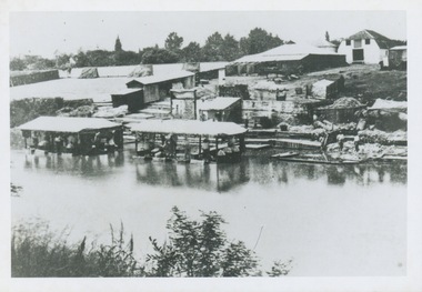
Print - 'Scouring Yards', River Yarra, Richmond
... scouring yards. - river yarra industry -- river yarra Reverse ...View of industry on the River Yarra at Richmond. The 'print' shows a number of buildings including pavilions built out into the water.Reverse: " Sheep pens / hide scouring plant on Yarra Richmond"scouring yards. - river yarra, industry -- river yarra -
 Kew Historical Society Inc
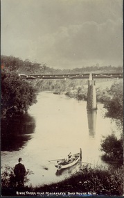
Postcard, River Yarra near Macauleys' Boathouse Kew, c.1910
The Pipe Bridge was constructed to bring fresh water from Fairfield to Kew. This bridge was destroyed in the 1934 Flood and later reconstructed.Early sepia real photo postcard of the first Pipe Bridge bringing water from the Yan Yean Reservoir to Kew. The site is upriver of the original Macauley's boathouse. Obverse: "River Yarra near Macauleys' Boat House Kew". Reverse: "(Pipe Water Line) / Kew to Fairfield above boat house / Pipe Bridge / Received from L. Bennett 1980".bridges - kew (vic.), bridges - yarra river -- kew (vic.), pipe bridge -
 Kew Historical Society Inc
Photograph - Crossing Dights' Falls on the Yarra by foot
... on the Kew side of the river, which pumped water uphill... on the Kew side of the river, which pumped water uphill ...Dight’s Falls in Studley Park is an artificial weir built on a natural rock bar across the Yarra. The weir was built in the 1840s to provide water to the ‘Ceres’ flour-mill, one of the first in Victoria. The falls were later to become known as Dight’s Falls after the owners of the mill. Later, a pumping station was built on the Kew side of the river, which pumped water uphill to a reservoir in Walmer Street that provided water to the Melbourne Botanical Gardens and to Albert Park Lake. The area around Dight’s Falls was and is frequently used for recreational activities.Rare original print photograph of people walking across Dight's Falls when the river flow was low. View west towards Abbotsford. Photograph taken from Kew side of river above the Falls.Reverse: "M Holmes"dight's falls, river yarra -- kew - abbotsford -
 Kew Historical Society Inc
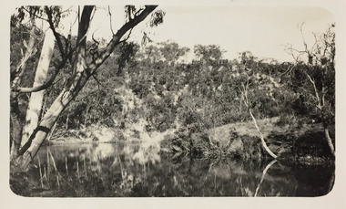
Photograph - Yarra River, Studley Park, 1924
Henry Beater Christian (1886-1962) , was a descendant of one of the earliest settler families in Kew. Employed at the Kew Asylum as a 'public servant', he was a skilled amateur photographer, photographing numerous scenes in Kew and on his travels around Victoria. The majority of his photographs date from 1916 to 1929. His finest photographs are housed in two photograph albums. Digital copy of a photograph from page 9 of the 47-page photograph album containing 261 gelatinous silver images, loaned by Diane Washfold with permission given to digitise and hold a copy in our collection. The point-of-view selected by the photographer, Henry Christian, is of a small section of the Yarra River at Studley Park. The still water and the reflection is the most noticeable aspect that he sought to capture in the image."Studley Park / Kew"henry beater christian (1886-1962), landscape photography, kew (vic.) — yarra river, christian-washfold collection, photograph albums, yarra river -- studley park (vic.) -
 Kew Historical Society Inc
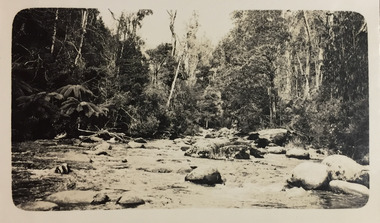
Photograph - Strickland Spur track, c.1926
Henry Beater Christian (1886-1962) , was a descendant of one of the earliest settler families in Kew. Employed at the Kew Asylum as a 'public servant', he was a skilled amateur photographer, photographing numerous scenes in Kew and on his travels around Victoria. The majority of his photographs date from 1916 to 1929. His finest photographs are housed in two photograph albums. Digital copy of a photograph from page 18 of the 47-page photograph album containing 261 gelatinous silver images, loaned by Diane Washfold with permission given to digitise and hold a copy in our collection. This photograph, dating from c.1926, forms part of a group of photos of the Strickland Spur track, taken on a bushwalking trip to Marysville, Victoria. John Chapman has written in 'Bushwalking Clubs - A Brief History', about the establishment in Victoria of the first bushwalking club in 1888, and the popularisation of bushwalking during the interwar period. The photograph shows either the Steavenson or Taggerty River near Marysville. The photographer contrasts the rapid flow of the water through the rapids with the stillness of the surrounding tree ferns and trees."Spur" [illegible ink inscription]henry beater christian (1886-1962), landscape photography, kew (vic.) — yarra river, christian-washfold collection, photograph albums, bushwalking -- victoria, strickland spur -
![Jebb's Pool, on the Erskine River, Near Lorne / [by] Nicholas Caire, circa 1876](/media/collectors/550653872162f11fb04854aa/items/57831524d0cdd1176c4c6452/item-media/5783159dd0cdd1176c4d1cd3/item-fit-380x285.jpg) Kew Historical Society Inc
Kew Historical Society IncPhotograph, Anglo-Australasian Photographic Company, Jebb's Pool, on the Erskine River, Near Lorne, c. 1876
Nicholas Caire was born on Guernsey in the Channel Islands in 1837. He arrived in Adelaide with his parents in about 1860. In 1867, following photographic journeys in Gippsland, he opened a studio in Adelaide. From 1870 to 1876 he lived and worked in Talbot in Central Victoria. In 1876 he purchased T. F. Chuck's studios in the Royal Arcade Melbourne. In 1885, following the introduction of dry plate photography, he began a series of landscape series, which were commercially successful. As a photographer, he travelled extensively through Victoria, photographing places few of his contemporaries had previously seen. He died in 1918. Reference: Jack Cato, 'Caire, Nicholas John (1837–1918)', Australian Dictionary of Biography.An original, rare photograph from the series 'Views of Victoria: General Series' by the photographer, Nicholas Caire (1837-1918). The 60 photographs that comprise the series were issued c. 1876 and reinforced a neo-Romantic view of the Australian landscape to which a growing nationalist movement would respond. Nicholas Caire was active as a photographer in Australia from 1858 until his death in 1918. His vision of the Australian bush and pioneer life had a counterpart in the works of Henry Lawson and other nationalist poets, authors and painters.'Jebb’s Pool, on the Erskine River, near Lorne’ : Views of Victoria (General Series) No.51 : Albumen silver photograph | Photo on card with Title and Description on reverse | Mounted 24 x 30 cm; Photo 12 x 17 cm.On Reverse: ‘Jebb’s Pool is situated about four miles from the township of Lorne, and is so called in consequence of a gentleman named Jebb, whilst crossing the cataract, having fallen in and was swept down by the current into a whirlpool which is continually in motion, owing to the particular formation of the river and the powerful current of water. The depth of water in the pool must be considerable, as but for the timely assistance rendered his life would have been sacrificed.’nicholas caire (1837-1918), lorne (vic), erskine river (vic), landscape photography - victoria -
 Kew Historical Society Inc
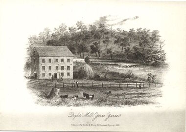
Print, Dight's Mill, Yarra Yarra
"In 1839 John Dight purchased Melbourne block 88, which included 26 acres of land along the Yarra River for £481 at the Port Phillip land sales held in Sydney. Dight was already in the business of flour milling and had a mill near Campbell Town in New South Wales called ‘Ceres’. In April 1840, he notified his customers through The Sydney Herald that he was leaving to go to Port Phillip. The first steam powered flour mill was constructed in Melbourne in 1841. Dight built his water powered mill, soon after, from bricks bought over from Tasmania. Dight used the river to power his mill: Water flowed along an inlet channel to turn an undershot water wheel. In order to regulate flow or to ensure flow for times when river levels were low, Dight constructed a rough stone weir. " (https://www.melbournewater.com.au/whatwedo/projectsaroundmelbourne/Documents/A_Short_History_of_Dights_Falls_Fact_Sheet.pdf) This work forms part of the collection assembled by the historian Dorothy Rogers, that was donated to the Kew Historical Society by her son John Rogers in 2015. The manuscripts, photographs, maps, and documents were sourced by her from both family and local collections or produced as references for her print publications. Many were directly used by Rogers in writing ‘Lovely Old Homes of Kew’ (1961) and 'A History of Kew' (1973), or the numerous articles on local history that she produced for suburban newspapers. Most of the photographs in the collection include detailed annotations in her hand. The Rogers Collection provides a comprehensive insight into the working habits of a historian in the 1960s and 1970s. Together it forms the largest privately-donated collection within the archives of the Kew Historical Society.An engraving of Dight's Mill on the Yarra. The image was originally published in Sands & Kenny, Melbourne & Sydney. Dorothy Rogers reproduced the print in 'A History of Kew' (1973). It faces page 8.Published by Sands & Kenny, Melbourne & Sydney, 1856dight's mill, dorothy rogers, dight's falls, yarra river, kew, john dight -
 Kew Historical Society Inc
Print, Sands & Kenny, Dights Mill, 1856
... stone weir." (Melbourne Water) dights mill yarra river ..."In 1839 John Dight purchased Melbourne block 88, which included 26 acres of land along the Yarra River for £481 at the Port Phillip land sales held in Sydney. Dight was already in the business of flour milling and had a mill near Campbell Town in New South Wales called ‘Ceres’. In April 1840, he notified his customers through The Sydney Herald that he was leaving to go to Port Phillip. The first steam powered flour mill was constructed in Melbourne in 1841. Dight built his water powered mill, soon after, from bricks bought over from Tasmania. Dight used the river to power his mill: Water flowed along an inlet channel to turn an undershot water wheel. In order to regulate flow or to ensure flow for times when river levels were low, Dight constructed a rough stone weir." (Melbourne Water)Dights Mill. Reproduction of a book plate from an original wood engraving, showing Dights Mill and Falls on the River Yarra. The image was originally published in Sands & Kenny, Melbourne & Sydney.Annotation on reverse: "Dights Flour".dights mill, yarra river -
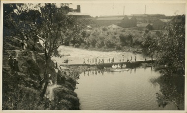
 Kew Historical Society Inc
Photograph, Edwin Anderson, 1st Kew Scouts, Water Rescue Training, 1924
... kew scouts yarra river, bulleen water rescue training 1924 ...The 1st Kew Scouts was one of the first Scout Troops in Victoria, being formed in 1909. From 1927 they met in a magnificent Scout Hall in Disraeli Street, Kew until it was demolished in 1993. Still operating (in 2020) from their new Scout Hall on the corner of Kilby Road and Kellett Grove, Kew.1st Kew Scouts undertaking water rescue training at Bulleen. The photograph was most likely taken while the Scouts were camping beside the river one summer, with the programs generally including not only fun and games but also varying training activities. At the time many locals swam in the river. 1924 was well before the construction of major water storage dams and urbanisation of the upper reaches of the Yarra River, which significantly reduced downstream flows and water quality. These days, the Scouts tend to raft and canoe in the Yarra, rather than swim. On front: 1924. On reverse: photographer's stampscouts - kew, 1st kew scouts, yarra river, bulleen, water rescue training 1924 -
 Kew Historical Society Inc
Headwear - Green Cotton & Yellow Silk Ribbon Smoker's or Lounge Cap, 1860s
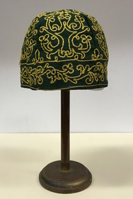
The context in which the hat was made and worn assists in establishing its potential historic significance. 'Bailliere's Victorian Gazetteer and Road Guide containing the most recent and accurate information as to every place in the Colony' (1870), describes the village of Vaughan as being located on the road from Daylesford to Castlemaine. In 1870 the Vaughan was deemed to be entirely a gold mining area, gold having been discovered in the district in 1853. Intriguingly the entry in the Gazetteer claims that the electoral division of Vaughan began at the junction of the Middleton Creek and the Loddon River, so perhaps the cap might have belonged to a member of a significant local family. In 1870, Vaughan had a population of about 1000 persons and included almost 300 dwellings. Articles from newspapers, published on Trove refer frequently to a Mr Middleton as a litigant in court cases before the Vaughan Court in the 1860s. By the 1870s, the Mt Alexander Mail, in an article on ‘Mining: The Pioneer Wheel’ describes the success of Mr Middleton and his Middleton’s Reef Gold Quartz Mining Company, which had built the largest water wheel in the Colony. The wheel was 20’ in diameter and 2’ wide. Quartz mining as practiced by companies such as Middleton’s had become necessary after the exhaustion of alluvial quartz mining deposits in the 1860s. So we can probably establish a link between the cap and a significant mining identity in the period in which the article was made. The historical significance of the cap is only one part of the story. Caps such as the Middleton example can also be items of aesthetic significance as they were typically, examples of women’s work, using published patterns in magazines such as the Ladies Home Magazine. While women might follow or adapt a published pattern, their choice of materials reflected what was available locally. The fine hand stitching on this example is evidence of high quality domestic needlework. The maker crafted the cap from five triangular pieces of cotton cloth, each piece lined with a faded yellow net. The net provides some stiffening for the cap and has a functional purpose in that it anchors the hand-stitched, looped design of yellow silk ribbon that decorates the surface of the cap. Gentleman’s smoking (lounging) cap believed to have been made in c.1860-69. The conical hat is made of a dark green cotton fabric embroidered with narrow ribbon of a paler green silk. The unlined rimless hat is made of four pieces of fabric. There is no evidence of the hat at one stage featuring a tassle. The original donation record noted that the cap had been made for, and was worn by, a Mr Middleton, of Vaughan in Central Victoria. Nilhats, smokers hats, men's clothing -
 Kew Historical Society Inc
Photograph, Floods in North Kew, 1971
Living with natural processes was frequently a challenge to early European settlers and later residents of what was in the 1850s administered by the Borondara Road Board. This was compounded by the area being bounded on three sides by rivers (Yarra River, Koonung Creek and Gardiner's Creek). In 1849, the historian James Bonwick recorded that "our district [Kew] suffered considerably. Mr Wade speaks of 80 acres, out of 100 acres of his cultivated paddock, covered by water." Newspapers continued to describe major flooding in Kew in 1863, 1869, 1878, 1880, 1889, 1891, 1916 and 1934. While the construction of the Upper Yarra dam in 1957 reduced the levels of flowing downstream, local and riverine floods continue.The Kew Historical Society's pictures and map collections testify to the impact of flooding in the district. They have historical importance in documenting the extent of flooding in the district and its affects on homes, services and recreation. Numerous photographs record flooding throughout the Twentieth Century.Floods in North Kew, 1971. Looking northeast towards Kilby Road from River Avenue. Annotation on reverse: map and date "8 Nov. 71 10.30am".floods (kew), yarra river, kew flood, kilby road flood -
 Kew Historical Society Inc
Photograph, Floods in North Kew, 1934
Living with natural processes was frequently a challenge to early European settlers and later residents of what was in the 1850s administered by the Borondara Road Board. This was compounded by the area being bounded on three sides by rivers (Yarra River, Koonung Creek and Gardiner's Creek). In 1849, the historian James Bonwick recorded that "our district [Kew] suffered considerably. Mr Wade speaks of 80 acres, out of 100 acres of his cultivated paddock, covered by water." Newspapers continued to describe major flooding in Kew in 1863, 1869, 1878, 1880, 1889, 1891, 1916 and 1934. While the construction of the Upper Yarra dam in 1957 reduced the levels of flowing downstream, local and riverine floods continue.The Kew Historical Society's pictures and map collections testify to the impact of flooding in the district. They have historical importance in documenting the extent of flooding in the district and its affects on homes, services and recreation. Numerous photographs record flooding throughout the Twentieth Century.Floods in North Kew, 1934. Vicinity of Willsmere Park.floods (kew) -
![Flooding at Chipperfield's Boathouse [East Kew], 1934](/media/collectors/550653872162f11fb04854aa/items/58cbaad5d0cec425b474bfb1/item-media/58cf6fbdd0cf9f331490feb0/item-fit-380x285.jpg) Kew Historical Society Inc
Kew Historical Society IncPhotograph, Flooding at Chipperfield's Boathouse, 1934
Living with natural processes was frequently a challenge to early European settlers and later residents of what was in the 1850s administered by the Borondara Road Board. This was compounded by the area being bounded on three sides by rivers (Yarra River, Koonung Creek and Gardiner's Creek). In 1849, the historian James Bonwick recorded that "our district [Kew] suffered considerably. Mr Wade speaks of 80 acres, out of 100 acres of his cultivated paddock, covered by water." Newspapers continued to describe major flooding in Kew in 1863, 1869, 1878, 1880, 1889, 1891, 1916 and 1934. While the construction of the Upper Yarra dam in 1957 reduced the levels of flowing downstream, local and riverine floods continue.The Kew Historical Society's pictures and map collections testify to the impact of flooding in the district. They have historical importance in documenting the extent of flooding in the district and its affects on homes, services and recreation. Numerous photographs record flooding throughout the Twentieth Century.Floods in North Kew, 1934. Chipperfield's Boathouse and the adding Moorings was located beside the Yarra River near the corner of Willsmere and Kilby Roads. The flood reached the roof of the Moorings, which can be seen in the photo.floods (kew), floods (kew) 1934, yarra river -
 Kew Historical Society Inc
Photograph, Floods in North Kew, 1934
Living with natural processes was frequently a challenge to early European settlers and later residents of what was in the 1850s administered by the Borondara Road Board. This was compounded by the area being bounded on three sides by rivers (Yarra River, Koonung Creek and Gardiner's Creek). In 1849, the historian James Bonwick recorded that "our district [Kew] suffered considerably. Mr Wade speaks of 80 acres, out of 100 acres of his cultivated paddock, covered by water." Newspapers continued to describe major flooding in Kew in 1863, 1869, 1878, 1880, 1889, 1891, 1916 and 1934. While the construction of the Upper Yarra dam in 1957 reduced the levels of flowing downstream, local and riverine floods continue.The Kew Historical Society's pictures and map collections testify to the impact of flooding in the district. They have historical importance in documenting the extent of flooding in the district and its affects on homes, services and recreation. Numerous photographs record flooding throughout the Twentieth Century.Floods in North Kew, 1934. Unidentified location on the Yarra Flood Plain at Kew.floods (kew) 1934, yarra river -
 Kew Historical Society Inc
Photograph, Floods in North Kew, 1934
Living with natural processes was frequently a challenge to early European settlers and later residents of what was in the 1850s administered by the Borondara Road Board. This was compounded by the area being bounded on three sides by rivers (Yarra River, Koonung Creek and Gardiner's Creek). In 1849, the historian James Bonwick recorded that "our district [Kew] suffered considerably. Mr Wade speaks of 80 acres, out of 100 acres of his cultivated paddock, covered by water." Newspapers continued to describe major flooding in Kew in 1863, 1869, 1878, 1880, 1889, 1891, 1916 and 1934. While the construction of the Upper Yarra dam in 1957 reduced the levels of flowing downstream, local and riverine floods continue.The Kew Historical Society's pictures and map collections testify to the impact of flooding in the district. They have historical importance in documenting the extent of flooding in the district and its affects on homes, services and recreation. Numerous photographs record flooding throughout the Twentieth Century.Floods in North Kew, 1934. Chipperfield's Boat House under flood.floods (kew) 1934, yarra river, chipperfield's boat house -
 Kew Historical Society Inc
Photograph, Floods in North Kew, 1934
Living with natural processes was frequently a challenge to early European settlers and later residents of what was in the 1850s administered by the Borondara Road Board. This was compounded by the area being bounded on three sides by rivers (Yarra River, Koonung Creek and Gardiner's Creek). In 1849, the historian James Bonwick recorded that "our district [Kew] suffered considerably. Mr Wade speaks of 80 acres, out of 100 acres of his cultivated paddock, covered by water." Newspapers continued to describe major flooding in Kew in 1863, 1869, 1878, 1880, 1889, 1891, 1916 and 1934. While the construction of the Upper Yarra dam in 1957 reduced the levels of flowing downstream, local and riverine floods continue.The Kew Historical Society's pictures and map collections testify to the impact of flooding in the district. They have historical importance in documenting the extent of flooding in the district and its affects on homes, services and recreation. Numerous photographs record flooding throughout the Twentieth Century.Floods in North Kew, 1934. Flood near the lagoon (Billabong?)floods (kew) 1934, yarra river -
 Kew Historical Society Inc
Photograph, Chipperfield's Boat House & Floating Pontoon, 1934
Living with natural processes was frequently a challenge to early European settlers and later residents of what was in the 1850s administered by the Borondara Road Board. This was compounded by the area being bounded on three sides by rivers (Yarra River, Koonung Creek and Gardiner's Creek). In 1849, the historian James Bonwick recorded that "our district [Kew] suffered considerably. Mr Wade speaks of 80 acres, out of 100 acres of his cultivated paddock, covered by water." Newspapers continued to describe major flooding in Kew in 1863, 1869, 1878, 1880, 1889, 1891, 1916 and 1934. While the construction of the Upper Yarra dam in 1957 reduced the levels of flowing downstream, local and riverine floods continue. A number of boat houses operated on both sides of the River Yarra at Kew. Chipperfield's Boat House was located on the Yarra near the corner of Kilby and Willsmere Roads.The Kew Historical Society's pictures and map collections testify to the impact of flooding in the district. They have historical importance in documenting the extent of flooding in the district and its affects on homes, services and recreation. Numerous photographs record flooding throughout the Twentieth Century.Floating pontoon at Chipperfield's Boat House where the canoes were stored, taken in 1934, presumably before the 1934 Flood. This area of the Yarra was shallow with a number of mid river sandbanks and a popular swimming area for locals.yarra river, chipperfield's boathouse, pontoon