Showing 123798 items matching "main-road"
-
 Surrey Hills Historical Society Collection
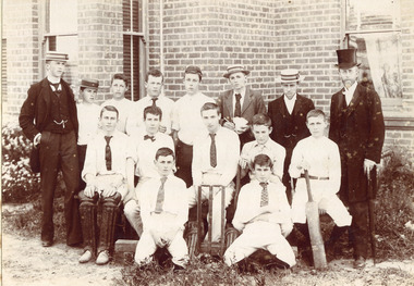
Photograph - Surrey College Cricket Team, 1899, 1899
Surrey College was opened in early 1892 by Reverend Dr Frederick Darling who had been the first minister of the Presbyterian Church in Canterbury Road. He resigned this position to open the school which operated until 1905 with additional premises at 12 Vincent Street. The main building fronted 219-233 Union Road. The school had 40 boarders as well as day boys. Courses included algebra, euclid, history, typewriting, shorthand and drill. In the 1930s, Nethercourt Private Hospital took over the site. Later it became St Jude's Hospital. Land in front of the building was sub-divided off in the 1970s. The building is still extant as a private dwelling with York Street, Surrey Hills as the address. This is one of 3 photos donated by Susan Hobbs, whose grandfather Rev. George Edward Downton is thought to have been a student at the college. George E. Downton was born in Avoca in 1885. He was later a missionary in New Guinea and Secretary to the Australian Board of Missions in Adelaide. He died in 1926 or 1927. This photo is one of two that were originally in the Box Hill Historical Society collection. They were transferred to us in 2024. The third photo could not be located. There was also a rough family tree and notes for the Downton family with correspondence regarding the donation but this was not found.Sepia photograph on grey mount board of 15 men and boys. Eleven of the boys are dressed in whites, 5 wearing ties and 1 a bow tie, one with a boater and one with a cap. The boy seated on the right is holding a cricket bat and the boy seated on left is wearing cricket pads on his legs. There are stumps and bails in the middle of front row. Three young men are in suits and boaters with one in the back row holding items in his hands. On the right hand side of the back row is Reverend Frederick Darling, Principal of the College, who wears a top hat and tails. There is a brick building behind with windows and blinds, and some foliage and plants behind and in front of boys. "Surrey College - Surrey Hills/Principal: Rev Fredk. A Darling, Melb. Unib./Cricket Team, 1899"schools, sport, cricket, 1899, surrey hills, surrey college, rev frederick a darling, george edward downton, susan hobbs, union road, nethercourt hospital, st jude's hospital, 219-223 union road, york street, 1890-1899 -
 Royal District Nursing Service (now known as Bolton Clarke)
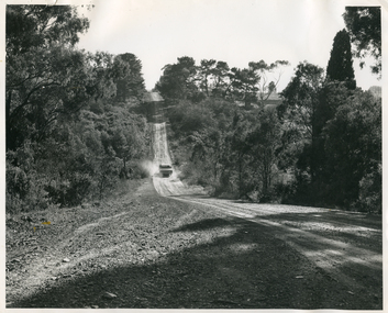
Photograph - Photograph, black and white, 23.05.1967
This photograph shows the typical road conditions encountered by RDNS District Sisters during their days work visiting patients to administer nursing care. From its inception in 1885 their Trained nurses (Nurses) of the then named Melbourne District Nursing Society (MDNS), later named Royal District Nursing Service (RDNS) gave high quality nursing care to patients in their own homes. They nursed patients referred by Hospitals and General Practitioners giving treatments, such as injections, wound care and doing other procedures, as well as assisting them with general care when required. District Nursing has had various modes of transport over the last 130 plus years. At first, from 1885 as MDNS, the Nurses walked the streets and lane ways amid the slums of central Melbourne. As the Society expanded public transport was used; bicycles were bought by the Society in 1903 and used in inner areas until 1945. During the Spanish flu epidemic, in 1919, MDNS appealed for assistance to procure Motor vehicles so the Nurses could visit an influx of cases. Through trusts, grants and donations four 'Ford 'T Model' cars were procured which enabled the Nurses to triple their visits. Through constant use the cars were in such a poor state they were sold in 1927. A Motor Auxiliary was formed in 1929 to take their Trained nurses (Sisters) to patients, and some Sisters used their own cars; even a motorcycle was used by one Sister in 1933. All these forms of transport were intermingled until, having received Royal patronage; the now Royal District Nursing Service (RDNS) had its own full fleet of vehicles by the mid 1960s. In many areas there were unsealed roads, in various conditions, which the Sisters negotiated to reach their patients to give care. By 2009 there were 598 cars in the fleet and the nurses travelled 9 million 200,000 kilometres – this is equivalent to 12 trips to the moon and back. In the centre of this black and white photograph is a Royal District Nursing Service, (RDNS) Sister in her RDNS grey car driving up the lower section of a hill on a dirt road. The car's rear black Victorian number plate, with 'JPH - 516' written on it can be seen. Dust is rising on either side of the car. In the foreground the road runs downward to a dip and then up the hill; trees are along either side of the road, and dirt and stones are seen on the side of the road in the left foreground. Photographers stamp. Quote No. GE 95rdns, royal district nursing service, rdns transport -
 Whitehorse Historical Society Inc.
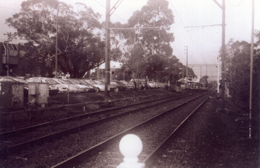
Photograph, Railway Track Looking East, 1/06/2009
One of a collection of photographs taken of the Nunawading Railway Station prior to the lowering of the railway line and building of the new railway station on the western side of Springvale Road so that the Springvale Road Rail Crossing can be eliminated.Black & white photograph of he precinct surrounding the Nunawading Station and the Springvale Road Railway crossing. This photograph is of the railway track looking east from railway crossing in Springvale road. Note the railway station in the distance. See NP 3545 to NP3567 for the complete set of photographsnunawading railway station, springvale road nunawading, redevelopment of railway line/springvale road. -
 Stawell Historical Society Inc
Document - Report, Nicole Start, Conservation Status of Roadsides in the Shire of Stawell, 1991
Covers: Shire, roadsides, Assessment: Species, Flora, Grazing, Cropping, Gravel, Noxious weeds, Firebreaks, Road Design. With loos maps X 2 in back. Author Nicole StartPlastic Front Cover. Yellow Paper with Photo of a country road.Nicole Start Biological and Chemical Sciences Ballarat University Collage December 1991 -
 Ithacan Historical Society
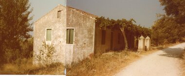
Photograph, Stavros 'Patriko', c1980s
The house was the family home of Yiannis Kallinikos, who was the grandfather of Poppy Doubaris nee Kallinikos. It is in the village of Stavros the largest village in Northern Ithaca. The word Stavros means cross roads.'Patriko' is the Greek word used for family home. Many old family homes in Ithaca have fallen into disrepair and ruin as a result of families having left the island and with each successive generation ownership has become very complicated. A coloured photograph of a stone cottage b y a road side. -
 Eltham District Historical Society Inc
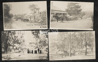
Photograph, Tom Prior, Group of scenes from the Eltham District, c.1905
Photo shows four images from the Shire of Eltham Pioneers Photograph Collection: SEPP_0501: West's Research Hotel, Main Road, Research, c.1907 SEPP_0612: Eltham, Main Road. Looking north from corner of Dudley Street, c.1904 SEPP_0616: Forming the footpath, Eltham, c.1906 SEPP_1000: Main Road, Hurstbridge, c.1905 Black and white/sepia photograph of four individual photographsbakery, eltham, eltham village reserve, footpath, gahan house, general store, haley's paddock, hurstbridge, luther haley, luther haley general store, main road, old mac (horse), picnic, pioneers and painters, punch (horse), railway store, research (vic.), research hotel, reynolds prior collection, richard reynolds, road construction, sepp, shire of eltham pioneers photograph collection, summer drinks, tilley lamp, york street -
 Orbost & District Historical Society
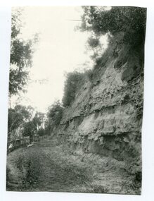
Photograph - Hofen's cutting, Bete Bolong, Orbost district, early 20th century
This photograph is of a cutting on a road at Bete Bolong known as Hofen's Cutting. This photograph was taken c. 1906 when transport was by horse, wagon and prior to cars and railways.This is a pictorial record of early Bete Bolong showing a road through a cutting which was known as Hofen's cutting. Two black / white photographs showing a dirt road heading down a cutting with a post and rail wooden fence on the left side in the background. In 958.1 there is a cut - away hillside beside the dirt road.on back - "Newmerella" (note: this location is at Bete Bolong and not on Newmerella Hill) 958.1 - on back - "Hofen's Bluff 1906"bete bolong, orbost, tracks/roads -
Phillip Island and District Historical Society Inc.
Publication, November, 1969
Produced and donated by Country Roads Board, 1969. Presented by Bill Papworth.Brochure produced by the Country roads Board for the Official Opening of the new bridge, November 21, 1969.local history, documents, publications, civil engineering, bridges, history of the phillip island bridge, phillip island bridges -
 Lakes Entrance Historical Society
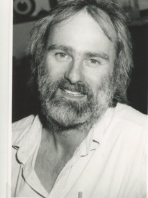
Photograph - Keith Graham of Woodsedge Gallery, Lakes Post Newspaper, 1/06/1994 12:00:00 AM
Keith Graham of Woodsedge Gallery Baades Road Lakes Entrance VictoriaBlack and white photograph of Keith Graham of Woodsedge Gallery Baades Road Lakes Entrance Victoriaarts, exhibition -
 Phillip Island and District Historical Society Inc.
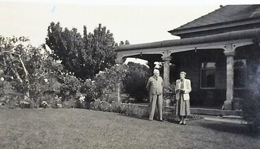
Photograph, Mr & Mrs W. Thompson, About 1950s
The house in the photo is the home of Rex and Molly Dixon, Ventnor Beach Road, Ventnor.Small, black & white photo of Mr & Mrs W. Thompson standing in front garden of house.local identities, rex and molly dixon, mr w. and mrs thompson, ventnor, houses -
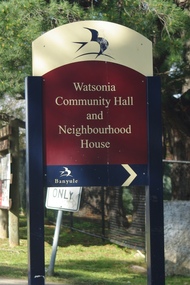 Greensborough Historical Society
Photograph - Digital image, Marilyn Smith, Watsonia Community Hall 2016, 11/08/2016
Sign at Watsonia Community Hall and Neighbourhood House, Lambourn Road Watsonia, 2016.Digital copy of colour photograph.watsonia, watsonia community hall -
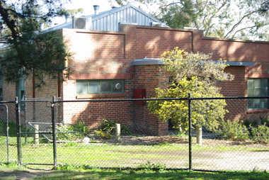 Greensborough Historical Society
Photograph - Digital image, Marilyn Smith, Watsonia Community Hall, from rear, 2016, 11/08/2016
Rear of Watsonia Community Hall and Neighbourhood House, Lambourn Road Watsonia, 2016.Digital copy of colour photograph.watsonia, watsonia community hall -
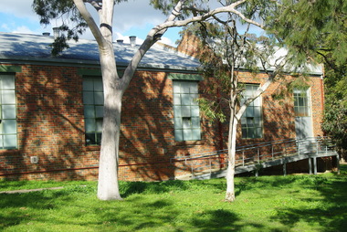 Greensborough Historical Society
Photograph - Digital image, Marilyn Smith, Watsonia Community Hall, from front, 2016, 11/08/2016
Front of Watsonia Community Hall and Neighbourhood House, Lambourn Road Watsonia, 2016.Digital copy of colour photograph.watsonia, watsonia community hall -
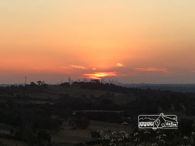 Eltham District Historical Society Inc
Photograph, Peter Pidgeon, Sunset over Melbourne from Kangaroo Ground, 16 Dec 2016, 16 Dec 2016
Viewed from Massaros Restaurant, Eltham-Yarra Glen Road, Kangaroo GroundBorn Digitalmassaros, eltham-yarra glen road, kangaroo ground, melbourne -
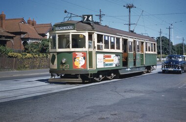 Melbourne Tram Museum
Slide, John Webster, 9/03/1960 12:00:00 AM
Colour slide, Kodak, white cardboard of Tram 823, in Riversdale Road, Hawthorn with the destination of Burwood Route 74. Tram has adverts for Chateau Taundra Brandy and ? Slide dated 9-3-1960.Hand writing on rear in ink "9-3-60- Track - Tram 823 Riversdale Road Melbourne"trams, tramways, riversdale rd, burwood, route 74, w5 class, tram 823 -
 Bayside Gallery - Bayside City Council Art & Heritage Collection
Map, H.B. Foot, Plan of the Brighton Estate containing 5120 acres, first special survey at Port Phillip, c. 1842
This plan records the Brighton Estate, also known as Dendy's Special Survey. In 1840 Henry Dendy, a farmer in Surrey, England acquired a "Special Survey" from the Commissioners for Land and Emigration which gave him the right to choose land in Port Phillip for the low price of £1 per acre for 5120 acres. Dendy appointed Jonathan Binns Were, as his agent, who later became a partner. Together, Dendy and Were decided on an area 5 miles south from Melbourne, bounded by North Road, East Boundary Road, South Road and to the west by Port Phillip Bay. Their Brighton Estate was first surveyed by T. S. Townsend in May 1841 and was re-surveyed by Robert Hoddle. Dendy and Were were making plans to sell the land and advertised a 30-guinea prize for the best subdivision which was to be divided into a village, marine residences, suburban and cultivation allotments, with the remainder being divided into country sections. The competition was won by H.B. Foot, who planned the village around a reserve and crescents and a 'green belt' forming the town boundary. brighton estate, dendy's special survey, special survey, henry dendy, jonathan binns were, w.b. were, survey, plan, map, brighton, george ward cole, baker's lithographer, hibernian, subdivision, town planning, cartographic material, h.b. foot -
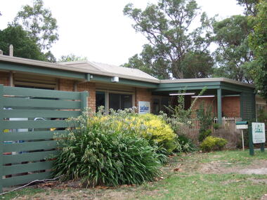
 Ringwood and District Historical Society
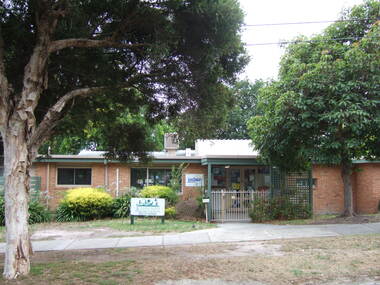
Photograph, Knaith Road Child Care Centre, Ringwood East showing front and entrance in January 2007
-
 Ringwood and District Historical Society
Photograph, Knaith Road Child Care Centre, Ringwood East, showing side angle of entrance in January 2007
-
 Ringwood and District Historical Society
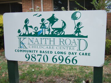
Photograph, Knaith Road Child Care Centre, Ringwood East - community based long day care - entrance sign in January 2007
-
 Ringwood and District Historical Society
Photograph, Knaith Road Child Care Centre, Ringwood East, side shot of entrance in January 2007
-
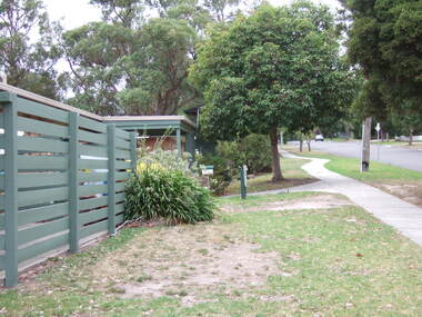
 Ringwood and District Historical Society
Photograph, Knaith Road Child Care Centre, Ringwood East, showing driveway to rear reserve in January 2007
-
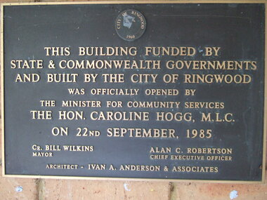 Ringwood and District Historical Society
Photograph, Knaith Road Child Care Centre, Ringwood East, plaque offically opened on 22nd September 1985 by Hon. Caroline Hogg MLC
Mayor Cr Bill Wilkins of City of Ringwood, Chief Executive Officer, Alan Robertson, architect Ivan A Anderson & Associates -
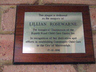 Ringwood and District Historical Society
Photograph, Knaith Road Child Care Centre, Ringwood East, plaque dedicated to the memory of Lilian Rosewarne, inaugural Chairperson of the Centre
-
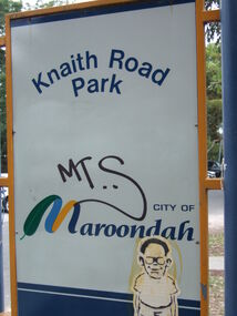 Ringwood and District Historical Society
Photograph, Knaith Road Park, Ringwood East, sign in January 2007
City of Maroondah -
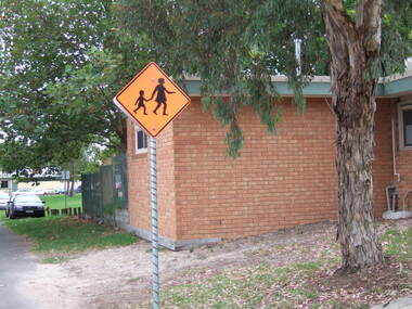
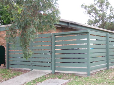 Ringwood and District Historical Society
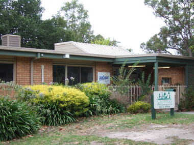
Photograph, Knaith Road Child Care Centre, Ringwood East, showing side view of building in January 2007
City of Maroondah -
 Ringwood and District Historical Society
Photograph, Knaith Road Child Care Centre, Ringwood East, eastern view of building in January 2007
City of Maroondah -
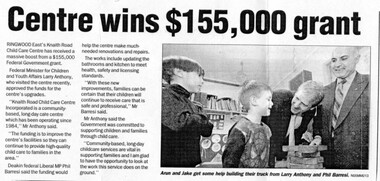 Ringwood and District Historical Society
Newspaper, Knaith Road Child Care Centre, Ringwood East, wins grant in 2003
Maroondah Leader 12 Aug 2003 -
 Ringwood and District Historical Society
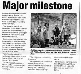
Newspaper, Knaith Road Child Care Centre, Ringwood East, planting tree by Phillip Barresi MP in 2003, to celebrate building's extensions
Maroondah Leader 7 December 2004 -
 Ringwood and District Historical Society
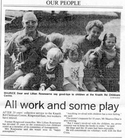
Newspaper, Knaith Road Child Care Centre, Ringwood East, retirement of Lillian Rosewarne (Executive) and Maurice Dear (Treasurer) after 10 years service in 1994
Ringwood Mail 19 October 1994 -
 Ringwood and District Historical Society
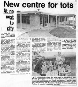
Newspaper, Knaith Road Child Care Centre, Ringwood East, start-up of centre on 8 July 1985
Ringwood Mail 26 June 1985