Showing 10510 items matching " sections"
-
 Ballarat Heritage Services
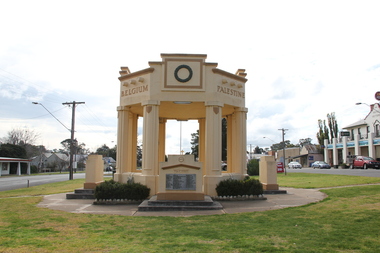
Photograph - Photograph - Colour, L.J. Gervasoni, Avoca War Memorial, 2011, 06/08/2011
The monument commemorates those from Avoca who have served in the various conflicts in which Australia has been involved. It was dedicated on18 November 1921. The memorial was later rededicated in 1988 to also remember those who served in the Second World War. During the First World War, 137 men from the Avoca area volunteered for the armed services and of this number 29 were killed. A plaque, unveiled in 1984, commemorates Sergeant Lewis McGee V.C who enlisted from Avoca in World War One. Colour photograph of the Avoca World War One. The Memorial is an octagonal building of rendered brick supported on eight columns with rounded engaged columns on the central section of each. At the top of the rounded section is a shield decoration. World War One Fallen Auls A. Beavis J. Beer C. Brown J.A. Brown J.N. Burns W. Dobley L. Driver W.H. Evans C.G.H. Fish W. Harrowfield N. Henderson J.H. Henry C.A. Howell T.P. Kiehl A. Lambert S. Lansdell H. Livingstone J. McArdle J.E.F. McDowell W.R. Oppy W. Rowlands W. Rowlands H. Smith S.W. Summers D.L. Templeton C. Turpin H. Willmott C. Wrigley F. Yates L.R. World War One Honour Roll Anderson N.W. Armstrong H.M. Barry R.E. Beavis JOHN. Blain J. Bowen L. Bradley H.J. Brazil F. Brereton W.C. Brereton C. Brown H. Burke J.F. Burke P. Burnett W. Cain H.C. Calnan C. Chandler R.W. Chandler H. Chaplan W. Coates E. Cross F. Cross C. Crute A.T. Cullip C. Daly J. Derrick E.A. Diamond C.P. Doodt D. Doodt C. Douglas J.O. Ebeling C. Elliot T. Elliot N. Elliot W.N. Ford H. Fraser D.C. French W. French W.H. French C. Garner J. Gee J. Gee F.R. Gibson C.A. Golder A. Golder F. Gollop H. Gouce W. Greenwood H. Greenwood W. Harbour H.J.H. Harris N. Harrow R. Harrowfield B. Hellings D. Henderson C. Henderson J.J. Henderson T.A. Hilderbrand W. Holland H.S. Hughes W. Jardine J.W. Jardine W.E. Jardine J.A. Johnson G. Johnson W. Johnson REG. Johns Kitchen G.R. Laidlow R.T. Larkins James. Leyden J.M. Leyden P.J. Lindsay F. Lyons P.L. McEwan F. McVicar F.C. McVicar A.A. Mitchell T.T. Moodie A. Nicholson E. Porter A.B. Randall W. Redpath S. Reeves H. Reid E. Resuggan A. Robinson R.W. Samers V. Scott R.V. Sims H.L. Stavely W. Torney S. Williams H. Willmott H. Wilmott D. Wilson B.C. Wilson A. Wiltshire C. Witherden T. Witherden D. Yates J.O. Young F. Johnson F. Kitchell P. Kitchen A.L.avoca, avoca war memorial -
 Melbourne Tram Museum
Ephemera - Timetable, Metropolitan Transit Authority (MTA), "Metropolitan Transit Timetables", Jan. 1984
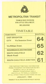
Set of 13 Metropolitan Transit Tram timetables, folded sheets, 8 to 10 sections, providing timetables for specific routes, day of week giving information on tram times at specific time points, route map, sections and fares and Transport Information Centre telephone number. All printed on yellow paper. .1 - Route 64 (65 via William St), 62 and 61 - dated January 1984. .2 - Route 3 (Darling Road via Swanston St) with route 377 bus on Sundays via Batman Ave. - July 1984 .3 - Route 5 - Malvern Burke Road - City - July 1984. Cover was printed showing route 35 via William St, but has been crossed out in pencil. .4 - Route 6 (Glen Iris - City) and Route 7 (Malvern Town Hall) - July 1984. Cover was printed showing route 36 via William St, but has been crossed out in pencil. .5 - Route 8 - Toorak - City - June 1984. Cover was printed showing route 38 via William St, but has been crossed out in pencil. .6 - Route 10 and 11 West Preston via Collins St and Route 13 via Latrobe St - March 1985. .7 - Route 10 and 12 - South Melbourne and St Kilda Beach - City (Brunswick St) via Collins St and route 17 - Park and Clarendon Sts. - Sept 1984 .8 - Route 15 and 22 - Moreland to City, July 1983 .9 - Route 15, 16 and 55 - St Kilda Beach to City via Swanston St - July 1983. Cover was printed showing route 53 via William St, but has been crossed out in pencil. .10 - Route 19 (Coburg), 18 (Brunswick) and 20 (Bell St) - City - August 1984 .11 - Routes 59 (Airport West), 49 (Niddrie), 52 (Bulla Road), 51 (Essendon Station) and 81 (Essendon Depot) - April 1985. .12 - Route 69 - Kew Cotham Road to St Kilda Beach - Sept. 1984 .13 - Route 72 (Camberwell - City), 32 via William St and route 73 (Camberwell Junction) - August 1984. .14 - Route 1 and 21 - East Coburg - City - August 1983. Full Image of .10 added 9/4/17 following a query about route 19 timetables - see image i6trams, tramways, the met, timetables, melbourne, latrobe st, la trobe st, mta, buses, route 64, route 65, route 3, route 5, route 6, route 8, route 10, route 11, route 12, route 13, route 17, route 15, route 22, route 16, route 55, route 19, route 18, route 20, route 59, route 49, route 52, route 51, route 81, route 69, route 72, route 32, route 73, route 1, route 21 -
 Bendigo Historical Society Inc.
Letter - MERLE HALL COLLECTION: ROSALIND PARK CREATIVE VILLAGE BENDIGO PROJECT LETTERS, 1994
Merle Hall Collection: Rosalind Park Creative Village Bendigo Project Letters 31 March 1994 To: Victorian Arts Council Members From Grant Finck Project Coordinator Content: Introduces himself as the coordinator for 12 months; to members looking for expression of interest, includes Information Sheet 1994 on what the Creative Village is. 27 October 1995 To: Mrs. Mearle Hall From: City of Greater Bendigo, Bernard Smith (Director Environmental Services) Content: Granting access to the Victoria Hill site for small quantities of geological material. 10 January 1996 To: Mrs. Mearle Hall From: City of Greater Bendigo, Bernard Smith (Director Environmental Services) Content: Endorsement of the project by the Council and confirmation that the Council will provide preliminary site work to allow the project to be enabled. Also advised the Arts Bendigo Mosaic Project makes contact with the Salvation Army (New Work Opportunity Project) 27 February 1996 To: Mrs. Mearle Hall From: Ken Beasley Manager Project Development The Smith Read Training Group. Content: LEAP Project Proposal - Mining Heritage Mosaic outlining the benefits of using LEAP Trainees to undertake the project. Proposed Scope of work outlining responsibilities of each participant. Bendigo Mining NL Environmental Trust Fund (Perseverance Exploration and Department of Energy and Minerals Victoria representatives) 27 June 1996 To: Mrs. Mearle Hall From: City of Greater Bendigo, Bernard Smith (Director Environmental Services) Content: Advising that the Council will match dollar for dollar funding for the engagement of an artist to supervise the construction of the Mosaic in Upper Rosalind Park up to $3,500. 22 July 1996 To: Anne Buzza From Geof Brown Camp Hill Primary School Content: Thanks for using and managing the school students to help create tiles. 9 October 1996 To: Mrs. Mearle Hall From: City of Greater Bendigo, Bernard Smith (Director Environmental Services) Content: Enclosed cheque for matching grant of $3500 15 October 1996 To: Mrs. Mearle Hall From: City of Greater Bendigo, Bernard Smith (Director Environmental Services) Content: Agreement to relocate the project facilities to the car park and to maintain a close liaison between the Council and Arts Bendigo. 13 November 1996 To: Mrs. Mearle Hall From: The Sidney Myer Fund Helen Morris Research Officer Content: Remittance advice for $1000 22 April 1997 To: Mrs. Mearle Hall From: John Little Administrator Victorian Arts Council Content: Remittance advice for $500 towards the project and enclosing 12 VAC Annual reports. 20 October 1998 To: Mrs. Mearle Hall From: City of Greater Bendigo, Andrew Hall (Director Community Development) Content: Advising that the Council will make a grant of $1090 for the purpose of printing of Brochures for Bendigo Heritage Mosaic. A service agreement to be signed before the issue of the grant, 21 March 2001 To: Mrs. Mearle Hall From: City of Greater Bendigo, Justin Hanney (Director Community Services) Content: A reference from Council supporting the project application to Vic Health for the development of a series of small mosaic pieces along the linear pathway asjacent to the Bendigo Creek. 12 November 1996 To: Mrs. Mearle Hall From: Arts Bendigo Inc. Content: Cheque for $2000 being first payment as under contract two for mosaic project. 4 December 1996 To: Mrs. Mearle Hall From: Arts Bendigo Inc. Content: Cheque for $2000 being second payment as under contract two for mosaic project. 27 July 1997 To: Maery Gabriel Mosaic Artist From: Arts Bendigo Inc. Content: Cheque for $2000 being final payment as under contract two for mosaic project. 12 June 1997 - Two copies To: Maery Gabriel Mosaic Artist From: Arts Bendigo Inc. Content: Agreement between Maery Gabriel (The artist) and Arts Bendigo Inc. to complete the final two sections of the Bendigo Heritage Mosaic at the base of the Rosalin Park Poppet Head, Bendigo with a design of approximately two square meters within each section. The work to be completed by the endo of July 1997, unless severe weather conditions make the laying impossible. Agreement for two lots of $2000. 14 June 1996 From: Maery Gabriel Mosaic Artist To: Arts Bendigo Inc. Content: receipt for 50% payment for two weeks and $60 Travelling expenses. 21 May 1996 Agreement between Arts Bendigo of P.O Box 563, Bendigo in the State of Victoria (hereinafter referred to as the ‘AB’ of the first part AND Meary Hall of Morningswood, Petersons Road, Ellinbank, 3821 in the State of Victoria (hereinafter referred to as ‘the artist’) of the second part. ENGAGEMENT: (a) AB engages the Artist to provide her services as Mosaic Artist for the design and creation of a Mosaic pavement surround to the poppet head lookout in Rosalind Park, Bendigo and matters incidental thereto at such schools, halls and any other places as required from time to time by AB and the Artist accepts the engagement upon the term and conditions hereinafter appearing. (b) Services to be provided by the artist include community consultation and design work in association with AB Co-Ordinator and Arts Bendigo, a minimum of six weeks of the artist’s time within the six months of the project. Completion of section one of the whole design with further work on the other sections to depend on available funding. The agreed fee was $5400 and $60 per visit to Bendigo with living away to be provided by Arts Bendigo 1 November 1996 Agreement between Arts Bendigo of P.O Box 563, Bendigo in the State of Victoria (hereinafter referred to as the ‘AB’ of the first part AND Meary Hall of Morningswood, Petersons Road, Ellinbank, 3821 in the State of Victoria (hereinafter referred to as ‘the artist’) of the second part. ENGAGEMENT: (a) AB engages the Artist to provide her services as Mosaic Artist for the design and creation of a Mosaic pavement surround to the poppet head lookout in Rosalind Park, Bendigo and matters incidental thereto at such schools, halls and any other places as required from time to time by AB and the Artist accepts the engagement upon the term and conditions hereinafter appearing. (b) Services to be provided by the artist include community consultation and design work in association with AB Co-Ordinator and Arts Bendigo, a minimum of six weeks of the artist’s time within the six months of the project. Completion of section one of the whole design with further work on the other sections to depend on available funding. The agreed fee was $5000 and $60 per visit to Bendigo with living away to be provided by Arts Bendigo, plus transfer of the diamond saw purchased by AB 28 August 1996 Memorial to Bendigo’s Mining Heritage and Traditions financial and other support as at August 128th Arts Bendigo Financial contribution: $7000 Local Busine Sponsors: $2800 City of Greater Bendigo Matching Above: $2800 City of Greater Bendigo Site works: Equiv, $12000 Local Businesses and institutions supplying goods and services to total value of: Equiv: $7600 Expenditure: Purchase of equipment, including diamond saw: $2000 Purchase of materials: $800 Artists design fees: $3000 Artists on site work, travel and accommodation: $12000 insurance, administration etc.: $700 31 May 1996 List of possible donors' checklist Undated Budget Sheet 21 September 1995 From: The Victorian Arts Council To: City of Greater Bendigo Content: Invoice for $5000 10 December 1995 From: Maery Gabriel artist To: Arts Bendigo Content: Invoice $1575 for design of Rosalind Park Lookout. 45 hours @ $35/hour 1 October 1996 Historic mining Mosaic Pavement, Rosalind Park Poppet Head Financial Statement as a October 1st, 1996 28 October 1996 From: Maery Gabriel To: Ann Buzza (representing Arts Bendigo) Report on project of Rosalind Park Mosaic as at October 1996. The report lists the difficulties faced with the weather, unsuitable facilities on site and problems with the LEAP team labour.victorian arts council, city of greater bendigo -
 Eltham District Historical Society Inc
Photograph, Tess Justine (Nillumbik Shire Council), Murray's Bridge over the Diamond Creek, Eltham North, 19 Feb 2022
Murray's Bridge over the Diamond Creek on the Diamond Creek Trail just prior to demolition and replacement with a new steel bridge. Heritage advice obtained by Nillumbik Shire Council, following a suggestion by the Eltham District Historical Society (EDHS), is that the original bridge appears to have been a simplified version of the Country Roads Board’s (CRB) standard timber bridge design of the early-to-mid 1920s. In c1990 Murray’s bridge was renovated with three recycled steel girders as part of a bike/pedestrian path in the reserve. During these alterations many parts of the bridge were removed, and some were replaced. Heritage advice indicates the condition of Murray’s bridge is poor. The remaining original parts are all in poor condition, with severe weathering, splitting and rot, especially to the stringers retained on the bridge. Heritage advice is that Murray’s Bridge does not have sufficient significance in the cultural history of the Nillumbik area to warrant inclusion in the Nillumbik Shire Heritage Overlay and also does not have sufficient significance as a rare survivor to warrant inclusion in the Nillumbik Shire Heritage Overlay. There are no indications in the historical record that this site was individually important to the cultural history of this area. EDHS is comfortable with the heritage advice provided to Council and has worked closely on this project with Council. EDHS has suggested some of the removed timbers be used in the vicinity of the bridge for landscaping and possibly seating, so as to retain these remnants close to the site of the original bridge, which is the last old timber bridge along the lower reaches of the Diamond Creek. Mary (Sweeney) Murray and John Wright Murray selected 80 acres, Lot C Section 16 and Lot 5 Section 17 Parish of Nillumbik, under an occupation license in 1866. John died in 1867 and freehold was granted to his son John in 1873. The farm was known as ‘Laurel Hill’. John Junior was an Eltham Shire councillor and sometime president from 1887 up until 1897. He added Lot A Section 16 to the farm in ca1888. John and his younger brother James arranged to rent/purchase Lot B Section 17, across Diamond Creek to the west, in ca1900. It appears that John and James farmed separately for a few years, with a new homestead built for James ad family on the high point of Lot B Section 17 in ca1910. John sold off Lot 5 Section 17 in 1912. When John died in 1912 James took over the land on both sides of the Diamond Creek. The old homestead on the west side of the Creek disappeared. A farm bridge over Diamond Creek from this period may have been located close to the northern boundary of the farm. John Langlands, owner of the farm known as ‘Ihurst’ on the west side of Diamond Creek to the south of the Murray’s land, died in 1907. In 1909 his land was then subdivided into 100 lots to become the ‘Glen Park Estate’. Other similar subdivisions of nineteenth century farms around Eltham in this period included the ‘Franktonia (or Beard’s) Estate’ to the northeast and ‘Bonsack’s Estate’ between Eltham and Greensborough. Soon after the opening of the railway extension line from Eltham to Hurstbridge in 1912, Glen Park and nearby residents including James Murray agitated for a railway station or siding to be located half-way between Eltham and Hurstbridge, so that the Glen Park residents who used the railway daily did not have to walk into the Eltham or Hurstbridge stations. Some believed Coleman’s Corner (opposite Edendale Farm) was an appropriate spot for the platform. James Murray was among those who thought the railway should be located on his land, closer to half-way between Eltham and Hurstbridge stations. The Railways Commissioners warned that the locals would have to fund these works themselves. The Glen Park Estate residents initially had difficulty accessing Eltham by road, with only an old low-level bridge over Diamond Creek at the south end of their estate. A new timber trestle bridge across the creek, now on Wattletree Road, was opened in 1915. Road access to the north was gained in 1927 when the new Murray’s Road, which crossed the Murray’s land, was built. Residents continued to agitate for a Glen Park station. By 1926 the Railways Commissioners’ preferred site was on the Murray’s land. They arranged an estimate of cost of a full-length platform. The estimate was too much for the locals, who in 1928 argued unsuccessfully for a shorter and hence cheaper platform. By 1929 Murray had agreed to donate the land, but the locals would still have to fund the works. Murray decided, unilaterally it would appear, to commence work on a timber trestle road bridge over Diamond Creek to link the new Murray Road to the proposed station. Late in 1929 he stopped work on the bridge, for reasons unknown, but started work again and completed the bridge in 1931. There is no further newspaper evidence of the campaign for the Glen Park station until 1939, when Murray and another local, Mr Maxwell, met the Railways Commissioner. The Glen Park locale now included 45 homes on the west side of the creek and 20 on the Eltham side. Most of the residents used the train every day. The Commissioner remained adamant that only a full-length platform could be built for safety reasons. It appears the campaign dissolved at this point. The increasing move to cars may have had an impact. There is no evidence of Murray’s bridge ever being connected to Murray’s Road, or of it having wide use for any purpose by locals. James Murray died in 1947 and the farm was taken over by his son James (Jim). Jim started to sell off parts of the farm in the 1980s, retaining a few acres around the ca1910 homestead and building a new house there. Recreation reserves were established along the creek. In ca1990 Murray’s bridge was renovated with steel girders as part of a bike/pedestrian path in the reserve. The old farmhouse was demolished in ca2014. * * * A theory posted on local community Facebook groups was that the bridge was built in the 1860s and was built to be more robust than was necessary for the movement of cows from one side of the creek to the other. It was suggested the robustness was necessary to support the weight of gold ore being transferred from a mine on Murray’s land to a railway siding near Murrays Bridge (presumably for transfer and processing at Diamond Creek). Perhaps this may have been one of the motivators for Murray, who really knows? Knowing when mining operations ceased on his land and how that fits the overall timeline would be useful but at the time the bridge was built, local gold production was minimal at best. The known facts are: • The railway line came to Eltham in 1902. • The extension of the railway from Eltham to Hurstbridge was constructed in 1912 so no railway line even existed through Murray's property until 1912 and the Victorian Railways maps at the time show no such siding on Murray’s property. • In 1923 a new company was formed in anticipation of the old Diamond Creek Gold Mine being re-opened. The mine had been previously closed and flooded. It was noted in the press at the time that the mine was within a mile of the railway. Nothing really came of this. • Construction of Murrays Bridge was commenced by James Murray in early 1929 in anticipation of a proposed flag station being nominated on his land, but work ceased shortly afterwards. The proposed flag station was commonly referred to as Glen Park as the residents of the Glen Park Estate wanted Option 1, located near them with the platform adjacent to Colemans corner. This was probably never going to fly as it was virtually in eyesight of Eltham station. Allandale Road was the third option, but the Commissioners' preferred option was No. 2 - on Murray's property. • The Railway Commissioners were not going to finance any such station and the works had to be funded by private landowners and residents, hence Murray investing in this himself. • Murray recommenced work two years later and finished his bridge in 1931 but unfortunately for him, the proposed flag station never eventuated. The bluestone siding you reference may well have been built by Murray as part of the proposed station platform. • Up until then, apart from the Main Road bridge, which was washed away in 1924, virtually all local crossings over the Diamond Creek were low lying bridges – Kaylocks Bridge at Brougham Street, Diamond Street bridge, Glen Park Road bridge. It is expected that Murray also had a low-lying bridge to connect his land either side of the creek. These were all washed away or severely damaged multiple times in the 1920s. Lessons were learnt, and Murrays Bridge appears to have been built in accordance with Country Road Board standards of the time. Flood damage was ongoing, and even more recently constructed raised bridges kept getting washed away, e.g., the new Wattle Tree Road bridge in 1958 just months after completion. Murray’s bridge was reinforced with steel some 30 years ago presumably to provide additional floodwater resistance, given the history of bridges disappearing in floodwaters. • In March 1932 it was reported in the Advertiser that there were still some prospectors operating around Eltham North who apart from further scarring the face of the earth over the previous two years had gained significant experience but little gold - hardly a driving factor for constructing a dedicated railway siding and bridge to transfer gold ore. It is far more probable that James Murray was hoping to have the railway station located on his property and invested his money by building the bridge to lead to it as well as a station platform. Had the station eventuated, it may well have driven up the value of his land for subdivision and new housing estates like the Glen Park Estate. That did not eventuate. Whilst the bridge was indeed old (90 years), the core structure being completed in 1931, it had been modified substantially from original and hence had no significant historic value – i.e., it was not a representative example of its type, construction, and age. Given that the bridge was not worthy of saving, the Eltham District Historical Society with Council’s support, and the Eltham Woodworkers group endeavoured to see what suitable sized timbers were salvageable to fabricate a commemorative seat. Unfortunately, the experts at the Woodworkers group were unable to salvage any suitable length/width timbers to fabricate the seat due to the presence of rot. Last remaining wooden trestle bridge on the Diamond Creek Trail just prior to demolition and replacementBorn digital image (27)diamond creek (creek), diamond creek trail, murrays bridge, ‘laurel hill’, john wright murray, mary (sweeney) murra, john murray jnr, james murray, john langlands, ‘ihurst’, ‘glen park estate’, beard's estate, franktonia, bonsack's estate, glen park estate, glen park railway station -
 The Beechworth Burke Museum
Photograph, Bayless C. - Manager, 1875
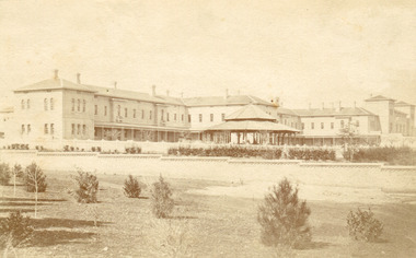
In this photo, taken in around 1875, is depicted the exterior of the Beechworth Mental Asylum buildings, with the administration buildings far right of the photo. A sunken boundary wall in the foreground and some people in view, sitting at the pavillion in the centre of the image. The two-storey buildings, designed in Italianate style, and the three-storey towers at the front, influenced by the asylum at Colney Hatch in England. The architecture of the buildings shares key features with other contemporary institutions, like Aradale at Ararat, and its design is attributed to the Public Works Department architect, J.J. Clark, whose name is connected with the construction of many other important public buildings, such as the Asylums at Kew and Ararat, the front block of the Royal Mint, Melbourne and the Melbourne Customs House. The Mayday Hills Hospital was constructed between 1864 and 1867, with buildings created in a number of periods. It formally opened on 24 October 1867 and, along with the Ovens Hospital and the Benevolent Asylum, made Beechworth a prominent social welfare centre in Victoria. Large masses of granite were excavated for its foundation and around 250 workmen were employed for its construction. The building, divided into six sections, was comprised of dormitories, doctors` rooms and plenty ancillary rooms and facilities, such as laundries, reading rooms, a concert hall and cooking areas. The site was chosen for its panoramic view of the countryside, the hilltop atmosphere and the native fauna, all contributing to the cure of patients. The Hospital was originally named the “Ovens Lunatic Asylum” but during the centenary celebrations in 1967 the name was officially changed to “Mayday Hills Hospital”, showing the gradual shift in the perception and understanding of mental health conditions over the last decades. The Hospital lies on the traditional land of the Kulin Nation.This photograph is historically significant as it provides an insight into the location, surroundings and the exterior of the Mayday Hills Hospital at the end of the 19th century. It also contributes to the understanding of the district`s development and its importance to the course of Victoria`s history and is acknowledged as a unique construction, being one of three identified as the largest of their kind.Black and white rectangular photograph printed on matte photographic paper mounted on board.Reverse: 37/ 3443/ Beechworth Asylum about 1875/ American & Australasian/Photographic Company/Victoria Branch./C.Bayless, Manager./ No./beechworth mental asylum, aradale, public works department, j.j. clark, melbourne customs house, colney hatch, italianate style, mayday hills hospital, royal mint, granite, benevolent asylum, dormitories, ovens lunatic asylum, ancillary rooms, centenary celebrations, three-storey towers, countryside, mental health conditions, kulin nation, concert hall -
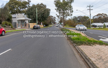 Eltham District Historical Society Inc
Photograph, Peter Pidgeon, Main Road, Eltham near Bridge Street instersection, 2 Aug. 2022
This section of Main Road was duplicated in 1968, from Pitt Street to Elsa Court. Generally speaking, the duplication was constructed on the western side. Comparison photo: SEPP_0626 Part of a presentation by Peter Pidgeon to the Society, 13 August 2022 showcasing a series of photographs taken by John Henry Clark over the period 1895 to 1930. John Henry Clark was the youngest of three boys born to William Henry Clark (1823-1877) and Maria White (1843-1914). He and his brothers, William Charles Clark (1872-1945), Clement Kent Clark (1874-1912) operated a photography business (Clark Bros.) from 25 Thomas Street, Windsor near Prahran during the period c.1894 to 1914. Following death of Clement in September 1912 and their mother in 1914, the Clark Bros business appears to have dissolved, the premises demolished, and a new house was under construction in 1915. John set up business independently in 1914 operating out of 29 Moor Street, Fitzroy where he is registered in the 1914 and 1915 Electoral Rolls. By 1916 John had relocated to Eltham where he continued his practice as a photographer and took many of the early images around the district of Little Eltham. Around 1930 John changed professions and opened a small cobbler's shop in 1931 near the pond opposite Dalton Street adjacent to the Jarrold family cottage. He never married and continued his profession as a bootmaker from this little shop, maintaining a close relationship with Mrs Jarrold for the rest of their lives. His bootmaker shop remains today beside the Whitecloud cottage and is one of only three remaining shops in the area from the early 20th century.Comparative photo taken 2022 with one taken from same location over 100 years earlier by noted local photographer J.H. ClarkBorn Digitaleltham, j.h. clark photo (2022), main road -
 Eltham District Historical Society Inc
Photograph, Stokes family with horse and sled, Nyora Road, Eltham, c.1950, 1950c
Taken from outside the family home on the southest corner of the intersection of Nyora Road and Pitt Street with Eucalyptus Road, looking northeast across the Stokes Orchard Frank Stokes with children, Dorothy (left), Beryl and David Frank Stokes first traveled to the district by train in 1944 to find land with the intention to establish an orchard. By chance he met Arthur Bird of Bird Orchard (bounded by Pitt Street, Eucalyptus Road and Wattle Grove) and they got talking over their common interest. Arthur put Frank up for the night and pointed out the land, part of Crown Allotment 15, Section 5, Parish of Nillumbik (CA15) somewhat diagonally opposite Bird Orchard. Frank bought the land and for the next two years would travel by train from Melbourne to Eltham every weekend establishing Stokes Orchard and building a home for his family, which they eventually moved into in 1946. In the mid 1970s the Shire of Eltham divided the orchard up into numerous rate-able parcel lots, which became affordable for Frank. As a consequence Stokes Orchard was turned into a housing development by Macquarie Builders and marketed as the Stokes Orchard Estate in two stages; Stage 1 encompassing Scarlet Ash Court, Ironbark Close and Peppermint Grove bounded by Nyora and Eucalyptus roads c.1976 and Stage 2 encompassing Stokes Place, Orchard Way, The Crest and The Lookout bound by Nyora and Diosma roads c.1979. The development of Orchard Way, The Crest and The Lookout did not proceed as planned due to the lack of the sewer along Diosma Road and so many of the proposed lots were incorporated into five-acre parcels instead.Representative of the orchard growing areas of ElthamDigital file only - Digitised by EDHS from a scrapbook (containing commercially printed photos of digital scans) on loan from Beryl Bradbury (nee Stokes), daughter of Frank Stokes.1950, beryl bradbury (nee stokes), beryl bradbury (nee stokes) collection, david stokes, dorothy stokes, eltham, frank stokes, horse, nyora road, sled, stokes orchard -
 Eltham District Historical Society Inc
Photograph, Looking south towards Nyora Road, Eltham, 1977, 1977
Viewed from near the end of Stokes Place where the linear reserve now runs between 8 and 9 Stokes Place just visible through trees in foreground, 24 Nyora with red roof is the first house in middle of view. Frank Stokes first traveled to the district by train in 1944 to find land with the intention to establish an orchard. By chance he met Arthur Bird of Bird Orchard (bounded by Pitt Street, Eucalyptus Road and Wattle Grove) and they got talking over their common interest. Arthur put Frank up for the night and pointed out the land, part of Crown Allotment 15, Section 5, Parish of Nillumbik (CA15) somewhat diagonally opposite Bird Orchard. Frank bought the land and for the next two years would travel by train from Melbourne to Eltham every weekend establishing Stokes Orchard and building a home for his family, which they eventually moved into in 1946. In the mid 1970s the Shire of Eltham divided the orchard up into numerous rate-able parcel lots, which became affordable for Frank. As a consequence Stokes Orchard was turned into a housing development by Macquarie Builders and marketed as the Stokes Orchard Estate in two stages; Stage 1 encompassing Scarlet Ash Court, Ironbark Close and Peppermint Grove bounded by Nyora and Eucalyptus roads c.1976 and Stage 2 encompassing Stokes Place, Orchard Way, The Crest and The Lookout bound by Nyora and Diosma roads c.1979. The development of Orchard Way, The Crest and The Lookout did not proceed as planned due to the lack of the sewer along Diosma Road and so many of the proposed lots were incorporated into five-acre parcels instead.Housing development in Eltham as an extension to the Woodridge EstateDigital file only - Digitised by EDHS from a scrapbook (containing commercially printed photos of digital scans) on loan from Beryl Bradbury (nee Stokes), daughter of Frank Stokes.1977, beryl bradbury (nee stokes) collection, nyora road, stokes orchard estate, stokes place -
 Eltham District Historical Society Inc
Photograph, Stokes Place, Eltham, July 1977, July 1977
Viewed from near the end of Stokes Place where the linear reserve now runs between 8 and 9 Stokes Place looking slightly east of south towards Nyora Road. The new Christian Church on Nyora now the Baptist Church visible in middle view. Frank Stokes first traveled to the district by train in 1944 to find land with the intention to establish an orchard. By chance he met Arthur Bird of Bird Orchard (bounded by Pitt Street, Eucalyptus Road and Wattle Grove) and they got talking over their common interest. Arthur put Frank up for the night and pointed out the land, part of Crown Allotment 15, Section 5, Parish of Nillumbik (CA15) somewhat diagonally opposite Bird Orchard. Frank bought the land and for the next two years would travel by train from Melbourne to Eltham every weekend establishing Stokes Orchard and building a home for his family, which they eventually moved into in 1946. In the mid 1970s the Shire of Eltham divided the orchard up into numerous rate-able parcel lots, which became affordable for Frank. As a consequence Stokes Orchard was turned into a housing development by Macquarie Builders and marketed as the Stokes Orchard Estate in two stages; Stage 1 encompassing Scarlet Ash Court, Ironbark Close and Peppermint Grove bounded by Nyora and Eucalyptus roads c.1976 and Stage 2 encompassing Stokes Place, Orchard Way, The Crest and The Lookout bound by Nyora and Diosma roads c.1979. The development of Orchard Way, The Crest and The Lookout did not proceed as planned due to the lack of the sewer along Diosma Road and so many of the proposed lots were incorporated into five-acre parcels instead.Housing development in Eltham as an extension to the Woodridge EstateDigital file only - Digitised by EDHS from a scrapbook (containing commercially printed photos of digital scans) on loan from Beryl Bradbury (nee Stokes), daughter of Frank Stokes.1977-07, beryl bradbury (nee stokes) collection, eltham, eltham christian church, stokes orchard estate, stokes place -
 Flagstaff Hill Maritime Museum and Village
Tool - Torch, 1935-1960
Diver's Submarine Electric Torches were first developed to give illumination for close examination work. They have to be self-contained, the older ones are powered by an accumulator type battery which could be recharged. Some models were fitted with a switch to turn the light off saving on the battery power. The lens is of a convex type and magnifies the light. Sometimes there was a protective grill across the glass or prongs to protect the glass from an impact. When fully charged the battery would last about seven hours. Torches are made from non-ferrous metal so as not to corrode in their watery environment. Siebe Gorman & Co Ltd has been producing hand-held, battery-powered, submarine electric torches for divers and the Ministry of Defence (MOD) since the 1920s. In 1961, the famous diving manufacturer C.E. Heinke merged with Siebe Gorman, and for a short while, torches were made with the combined 'Siebe Heinke' inscription. However, this linked inscription was later dropped, with a return to the Siebe Gorman name tag. Date of manufacture for these torches can be determined by their Admiralty Pattern (AP) number that was used to identify a particular item and were for naval stores use. Before NATO stock coding became more widely used, earlier MOD torches often have a simple four-digit group of AP numbers such as AP4456 or AP4458. In 1975 Siebe Gorman moved from their Neptune Works at Chessington in Surrey to a new location at Cwmbran in Wales and by this time their manufacture of diving equipment had declined. (For additional historic company information on Siebe & Gorman see notes section this document.)The item is significant as it gives us a snapshot into marine history and the development of diving equipment generally, especially that used for salvage operations before and during WW2. The company that made the torch Siebe Gorman was a leading inventor, developer and innovator of marine equipment with its early developments in helmets, compressors and other diving equipment. Items that are today eagerly sought after for maritime collections around the world. The items that have been donated to the Flagstaff Hill collection give us an insight as to how divers operated and the dangers they faced doing a very necessary and dangerous job.Diver's Torch brass with heavy glass screw on piece with four lugs attached contact spring inside. Leather hand strap missing."Siebe Gorman and Co Ltd, Makers, London." Has "A.P.4458" inscribed on front above glassflagstaff hill, warrnambool, shipwrecked coast, flagstaff hill maritime museum, maritime museum, shipwreck coast, flagstaff hill maritime village, great ocean road, siebe, gorman, diver's torch, torch, diver, diving accessories -
 Flagstaff Hill Maritime Museum and Village
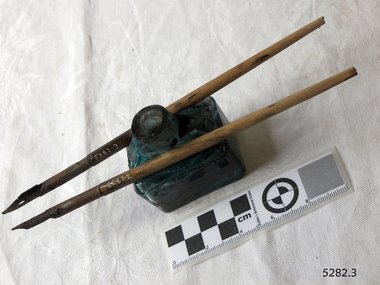
Container - Ink Bottle with pens, Early 20th century
This handmade, aqua glass ink bottle's design is sometimes called a ‘boat’ shape. The base was mouth-blown into a rectangular mould, evidenced by the lack of seams, the pontil, crease lies and the uneven thickness of the glass. The shoulder section was mouth-blown into a two-piece mould and then cut off from the blowpipe. The lip is sometimes referred to as a 'burst-lip, which was often filed to be smooth. This method of making bottles was often used in the mid-to-late 19th century. The bottle would then be filled with ink and sealed with a cork. More expensive bottles would have a lip added, which was more time-consuming and costly. The capacity for a bottle such as this was about 3 ½ oz (ounces) equal to about 100 ml. Pens are a common item for that period. Pen and ink have been used for handwriting since about the seventh century. A quill pen made from a bird’s feather was used until the mid-19th century. In the 1850s a steel point nib for the dip pen was invented and could be manufactured on machines in large quantities. The nis only held a small amount of ink so users had to frequently dip the nib into an ink well for more ink. Handwriting left wet ink on the paper, so the blotting paper was carefully used to absorb the excess ink and prevent smudging. Ink could be purchased as a ready-to-use liquid or in powdered form, which needed to be mixed with water. In the 1880s a successful, portable fountain pen gave smooth-flowing ink and was easy to use. In the mid-20th century, the modern ballpoint pen was readily available and inexpensive, so the fountain pen lost its popularity. However, artisans continue to use nib pens to create beautiful calligraphy.The ink bottle is of interest, being made of aqua glass rather than the more common clear glass. This set of ink bottles and pens is significant because of the bottle's method of manufacture, which is representative of a 19th-century handcraft industry that has now been largely replaced by mass production. The bottle and pens are historically significant as tools used for handwritten communication until the mid-20th century when fountain pens and modern ballpoint pens became popular and convenient and mechanical typewriters became part of standard office equipment.Victorian 'Boat' ink bottle, small rectangular, aqua glass ink bottle with grooves along the long sides for pen rests. The base has a pontil, no seams, and the glass is uneven in thickness. The shoulder has two side seams and there is a ridge where it is joined onto the base; there are round indents on each of the shoulder, on the short sides, four in all. The mouth has rough edges. The neck leans to one side. The glass has impurities, crease lines and bubbles. There is dried ink in the bottle. Two pens with metal nibs are included with the ink bottle. flagstaff hill, warrnambool, maritime museum, maritime village, great ocean road, shipwreck coast, ink, nib pen, writing ink, writing, copying, banks, lawyers, commerce, student, permanent ink, stationery, record keeping, handwriting, writing equipment, writing accessory, office supply, cottage bottle, boat bottle, mouth-blown bottle, two-part mould, sheer-lip bottle, burst-lip, cork seal, copy ink, aqua glass -
 Flagstaff Hill Maritime Museum and Village
Tool - Torch, 1935-1960
Diver's Submarine Electric Torches were first developed to give illumination for close examination work. They have to be self-contained, the older ones are powered by an accumulator type battery which could be recharged. Some models were fitted with a switch to turn the light off saving on the battery power. The lens is of a convex type and magnifies the light. Sometimes there was a protective grill across the glass or prongs to protect the glass from an impact. When fully charged the battery would last about seven hours. Torches are made from non-ferrous metal so as not to corrode in their watery environment. Siebe Gorman & Co Ltd has been producing hand-held, battery-powered, submarine electric torches for divers and the Ministry of Defence (MOD) since the 1920s. In 1961, the famous diving manufacturer C.E. Heinke merged with Siebe Gorman, and for a short while, torches were made with the combined 'Siebe Heinke' inscription. However, this linked inscription was later dropped, with a return to the Siebe Gorman name tag. Date of manufacture for these torches can be determined by their Admiralty Pattern (AP) number that was used to identify a particular item and were for naval stores use. Before NATO stock coding became more widely used, earlier MOD torches often have a simple four-digit group of AP numbers such as AP4456 or AP4458. In 1975 Siebe Gorman moved from their Neptune Works at Chessington in Surrey to a new location at Cwmbran in Wales and by this time their manufacture of diving equipment had declined. (For additional historic company information on Siebe & Gorman see notes section this document.)The item is significant as it gives us a snapshot into marine history and the development of diving equipment generally, especially that used for salvage operations before and during WW2. The company that made the torch Siebe Gorman was a leading inventor, developer and innovator of marine equipment with its early developments in helmets, compressors and other diving equipment. Items that are today eagerly sought after for maritime collections around the world. The items that have been donated to the Flagstaff Hill collection give us an insight as to how divers operated and the dangers they faced doing a very necessary and dangerous job.Divers torch, brass with glass lens , screw on piece with three lugs attached. Leather wrist strap attached & loose contact spring inside."Siebe Gorman and Co Ltd, Makers, London." Has A.P.4456 stamped on front faceflagstaff hill, warrnambool, shipwrecked-coast, flagstaff-hill, flagstaff-hill-maritime-museum, maritime-museum, shipwreck-coast, flagstaff-hill-maritime-village -
 City of Moorabbin Historical Society (Operating the Box Cottage Museum)
Photographs,x3 Colour Early Weatherboard Cottage Cheltenham c1880, 1981
Henry Dendy , a farmer from Sussex England, purchased 5,120 acres of land in the area of a 'Special Survey 1841' that extended from Brighton bayside North Road, East Boundary Rd to South Road. This area became known as Dendy's Brighton and as part of the sale 139 emigrant workers arrived in 1842 however Dendy was unable to find work and lodgings for these people. J.B.Were, financier took over the management of the 'Special Survey 1841' area and began to sell and lease allotments. 1850 the Squatter King brothers sold land south of Dendy's 'Special Survey 1841' to Josiah Holloway who sectioned it into 2 acre lots @ £10 each for market gardens - 'Two Acre Village' and Charles Whorral opened a small hotel - 'The Cheltenham Inn' on the main Road - Arthur's Seat Rd, later Point Nepean Rd, now Nepean Highway. Notable settlers who moved into the area were Keys, Charman, Bruton, Le Page, Fairlam, Meeres and 1862 saw the separation from Brighton and the formation of the Mooorabbin Roads Board District. .By 1879 1000settlers were living in 'Cheltenham' serviced by a Post Office with Bank, Mechanics Institute, State School No 84,Keys Hotel, Meeres Store, Sir Thomas Bent ensured the new Railway Line from Caulfield to Mordialloc went through his constituency of Cheltenham 1881 and this changed the development to the bayside area of Cheltenham away from the 'Two Acre Village ' side causing some dissention, However Cheltenham as whole prospered and this house in Pine St is typical of the cottages built c 1890- 1900 in the area. This weatherboard house c 1890-1900 in Pine St Cheltenham is typical of those built for early settler families. Photo taken 1981 by CMHS member 3 x Colour photographs of an early c 1900 weatherboard house in Pine St Cheltenham taken by CMHS member 1981Kodak Aug. 81 / Handwritten Pine St Cheltenhamkeys robert, holloway josiah, king brothers, smith j l; smith mary ann, stanley helen, chaff cutter, horse drawn carts, toll gates brighton, motor cars 1900, steam engines, early settlers, bentleigh, parish of moorabbin, city of moorabbin, county of bourke, moorabbin roads board, shire of moorabbin, henry dendy's special survey 1841, were j.b.; bent thomas, o'shannassy john, king richard, charman stephen, highett william, ormond francis, maynard dennis, market gardeners, vineyards, orchards -
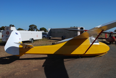 Australian Gliding Museum
Machine - Glider - Sailplane, 1937
The Golden Eagle is an original design by Geoff Richardson. Geoff commenced gliding in the early days of the sport circa 1933 in Melbourne, flying at Coode Island and Mt Frazer. In 1934, he began construction of a secondary type glider but scrapped it upon realizing that a better design was needed. He conducted further research and came up with a sailplane of similar size and general arrangement to the Grunau Baby but with a “Gull” wing using a Gottingen 535 wing section (the same as for the Grunau Baby). Geoff did all the technical calculations himself and even made up and tested a Casein glue for the construction. Geoff competed construction of his new sailplane (which he called the “Golden Eagle”) in 1937 and it was test flown at Laverton at the western edge of Melbourne in September 1937. On the same day, at Laverton, the Gliding Club of Victoria flew its new Grunau Baby 2 sailplane which it had imported as a finished machine from Edmund Schneider in Germany. The Golden Eagle was found to fly well, having a similar performance to the Grunau Baby. In the 1950s, the Golden Eagle was modified by rebuilding the front of the fuselage to enclose the cockpit with a Perspex canopy. A landing wheel was incorporated behind the skid. Spoilers were added to the wings and a trim tab to the elevators. The Golden Eagle has been flown with the VMFG (Victorian Motorless Flight Group) for most of its long life. When donated to the Australian Gliding Museum in 2016 by Alan Patching it was probably the oldest, continuously airworthy glider in the world. Having regard to the historical significance of the Golden Eagle, the Museum has decided to not to fly it anymore to avoid risk of loss or damage. The exhibit is of great significance for Australian gliding history – the Golden Eagle is a flyable 1930s aircraft in excellent condition that was designed and built by an Australian gliding pioneer. Single seat wood and fabric sailplane finished with white wings, tailplane and rudder and yellow fuselage Registration letters “FC” on fuselage nose port side, Australian flag, Vintage Gliders Australia and VMFG decals on rudder, “Golden Eagle” lettering in red on each side of the fuselage below the canopy, Aboriginal flag decal on port side of fuselage below the canopy. australian gliding, glider, sailplane, golden eagle, richardson, patching, vmfg, victorian motorless flight group -
 Nillumbik Shire Council
Reinis ZUSTERS (b.1918 Ukraine, arr.1950 Aus - d.1999 NSW Aus), Sunday Morning Montsalvat, 1979
Reinis Zusters OAM was born 15 October 1918 in Odessa, Ukraine, of Latvian parents. Zusters’ father died before he was two years old and he was raised in an orphanage from an early age. He had one sister. He studied Art at the Riga Technical College, Latvia, from 1935 to 1940. He married Aldija Kapteinis, and they had a daughter, Rudite (born 1942 in Riga). After World War II the Zusters family were refugees. They reached Western Australia in 1950, where they stayed for 6 months before moving to Canberra, ACT. In 1952, Zusters moved from Canberra to Pennant Hills in Sydney with his second wife, Arija Biks. Their daughter Laura was born in Sydney in 1956. In 1966, Zusters met his future third wife, Venita Salnajs. In 1969, Zusters bought a house in Greenwich, Sydney. He married Venita on September 17, 1976, and they moved to Wentworth Falls in the Blue Mountains. Zusters died on 8 October, 1999 at Wentworth Falls, and was cremated at Rookwood Crematorium, Sydney. His ashes are buried in the Latvian section of Rookwood Cemetery. Zusters studied at the Technical College of Riga (Latvia), and at East Sydney Technical College, Australia. He was influenced by his Latvian cultural heritage, and admired the artist Voldemars Tone (1892-1958). Shortly after arrival in Australia, Zusters became a draughtsman with the Department of Works and Housing in Canberra. Later he was appointed chief designer with the Australian-American architectural firm Austin-Anderson, at St. Leonards, Sydney. Zusters practised as a full-time professional artist from 1968. Zusters was a prolific painter, predominantly in oils. He produced many large landscapes, including triptychs of the Blue Mountains. His landscapes were mountain scenes prepared in the manner of Jackson Pollock and completed with washes and pale glazes of colour. His cityscapes featured a rich paint surface and sharp-edged thickness of paint applied with a palette knife, layer upon layer. He painted urban scenes of Sydney, inland Australian scenes, and several major portraits including Sir Winston Churchill’s gardener (purchased by Art Gallery of NSW). He made many small informal portrait-drawings of friends. His usual signature was “Zusters”. His work is represented in numerous public and private collections in Australia and abroad. He won numerous prestigious awards in Australia, Japan and USA and was honoured with the Order of Australia Medal in 1994. -
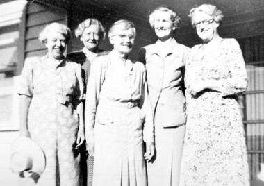 Surrey Hills Historical Society Collection
Photograph, Miss Jane Elizabeth (Jean) Pearson and her sisters in 1952, 1952
Miss Jane Elizabeth (Jean) Pearson is second from the left. From c1927 - c1950 Miss Pearson had the cake and confectionery shop at 147 Union Road. It was later a milk bar, next to Henry Jamieson’s radio and electrical shop. Miss Pearson sold Farey’s cakes which were very popular and in a trellised-off section also served morning and afternoon teas. Her sisters often helped. Silversticks, white knights, licorice straps were among a wide selection of sweets to be bought for 1d. – or even ½d. Jean was one of a large family born to John William Pearson and Agnes Yeaman. Jean was born at Riddell's Creek in c1884. She died in 1966. She had 3 brothers and a total of 6 sisters. Lillias Irene and Grace Stewart died in infancy or childhood, so the other sisters in the photo were (not necessarily in order): Ethel Agnes born in 1885, who married James Charles Robertson; Catherine Myra born in 1887, unmarried; May Dempster born 1891, unmarried; and Stella Christie born 1897, who married Cecil Hunt Aston in 1928. Jean was in business as a confectioner at 3 High Street, Malvern in 1927; in Union Road 1941-1949 and resided (presumably in retirement) at 37 Mayston Street, Hawthorn in 1954. At the later address May and Catherine are also listed variously in 1954 and 1963. (Ref: electoral rolls). The Hawthorn address was the 'family home' - address of John William Pearson who died in 1944, appointing Jean as his executrix. (Ref: Trove - The Argus 19 July 1944) Black & white copy of a group of 5 smiling older women with a strong family resemblance against a weatherboard background.147 union road, (miss) jean pearson, surrey hills, milk bar, shops, confectionary shop, cake shop, tea rooms, (miss) jane elizabeth pearson, (miss) ethel agnes pearson, (mrs) ethel agnes robertson, (miss) catherine myra pearson, (miss) may dempster pearson, (miss) stella christie pearson, (mrs) stella christie aston, (mr) john william pearson, (miss) agnes yeaman, (mrs) agnes pearson -
 The Beechworth Burke Museum Research Collection
Card (Series) - Index Card, George Tibbits, Ford Street, Beechworth, 1976
George Tibbits, University of Melbourne. Faculty of Architecture, Building and Town & Regional PlanningIndex system that support the research for Beechworth : historical reconstruction / [by] George Tibbits ... [et al]Arranged by street names of BeechworthEach index card includes: street name and number of property, image of property, allotment and section number, property owners and dates of ownership, description of the property according to rate records, property floor plan with dimensions.beechworth, george tibbitsbeechworth, george tibbits -
 Wodonga & District Historical Society Inc
Photograph - Mann Collection Album - Dunstan's Corner, Wodonga, C. 1970s
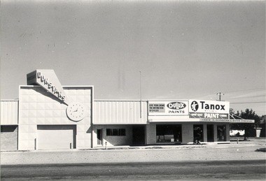
These town photos are part of a collection donated by Elaine Mann. Elaine was married to David Mann, a successful Wodonga businessman and community leader who passed away in Wodonga in June 2012. David was a member of the Mann family who began their business in Wodonga in 1920. Elaine was a teacher in Wodonga for many years and an active member of the community. Arthur Dunstan Hardware Arthur Dunstan established mills at Red Bluff on the Mitta and a timber yard at Wodonga. He also built a sawmill at Glen Wills in 1931 which operated for about 16 years. A larger and more modern sawmill with drying kilns was erected at Eskdale in 1947. He was contracted to build Wodonga’s Municipal sale yards in 1935, followed by the Wangaratta sale yards. This created so many forward orders that he bought a large block of land on the corner of Beechworth and Tallangatta Roads and opened a timber mill and hardware store. The business stood on this corner for about 40 years. A large proportion of the company's timber output was processed at the Wodonga yards into flooring, weatherboards, mouldings etc. and practically the whole output was distributed locally and throughout the Riverina and eastern areas of New South Wales, and Canberra. At its peak Dunstan’s was one of the biggest sawmilling businesses in Victoria and in Wodonga employed 150 people and milled l6,000,000 super feet of timber annually. A super foot is a measurement for timber, equal to one foot square by one inch thick. Arthur Dunstan also built Tower Place in High Street. He died in Wodonga in 1963 and the business was continued on by his sons. Dunstan’s timber yards in Wodonga were sold to Ezerd Industries in 1987 with the retail section being bought by BBC Hardware.This photo collection is of significance as it documents how the businesses and buildings in Wodonga have evolved and contributed to community throughout the late 20th century. A. Dunstan & Sons Hardware was located at the roundabout on the corner of High Street and Thomas Mitchell Drive (Formerly Tallangatta Road). "Southside Terrace" now occupies this site.wodonga businesses, high st wodonga, dunstan's hardware wodonga -
 Wodonga & District Historical Society Inc
Photograph - Tooles, Wodonga
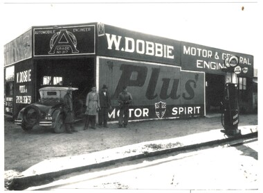
Patrick Toole was born in Corowa on 7 September 1913. In the early 1930s the family moved to Wodonga. Pat became an apprentice mechanic with Bill Dobbie and became a partner in 1936. Patrick Toole took over business in his own right on 23 August 1939. Toole’s Motors also ran a car and truck agency, a towing and crane depot, as well as a small disposal section. After breaking his leg in 1963, Pat extended the disposals business and by 1965 it was running as Wodonga Disposals and later, Toole’s Disposals. At their peak Toole’s employed 70 people across their various businesses including the garage, wreckers, towing businesses, a storage shed at Bandiana and the Disposal Store. Pat died in Wodonga on 10 November 1976 and the Disposals Store was taken over by his twin sons, Frank and Bill. His other sons, Pat and Jim ran the North Eastern Truck Wreckers. Tooles Disposals acquired most of their stock from Government auctions and also became licensed second hand dealers. They sold a wide range of military and non-military equipment from clothing to footwear and equipment for cooking and camping. They also shipped scrap metal to Japan and sourced uniforms and other items from Japan and East European countries. The business continued on the corner of High Street and Stanley Street for over 70 years, but the Toole family decided to sell the building in 2009. The building was eventually sold to a local business consortium in 2010. Toole’s continued to operate until May 2011. Thee building was demolished in 2013. Bill Toole continued Toole’s Disposals as an online business with numerous Australian and international clients.These images document an important and long standing business in Wodonga.A collection of images and a business card for the company of Tooles Garage and Disposals in Wodonga. Images depict the business at various stages in its development over more than 70 years.Photo 1 Beneath image - 1929 W. DOBBIE MOTOR & GENERAL ENGINEER / Con Lindsay, Alec Padgett, Bill Dobbie, Pat Toole Photo 2 Beneath image - 1940 A. L. TOOLE MOTOR & GENERAL ENGINEER / Fay Fulford, Gerry Nelder, Mick Presnell, Pat Toole Photo 3 On building - TOOLES MOTORS est. 1939/ TOOLES MOTORS PTY. LTD./ DISPOSALS/ DISPOSALS AT CITY PRICESt Photo 4 On sign - TOOLES DISPOSALS Photo 5 Business cardwodonga businesses, toole's disposals, businesses high street wodonga -
 Melbourne Legacy
Badge, R.S.S.I.L.A. Member Badges
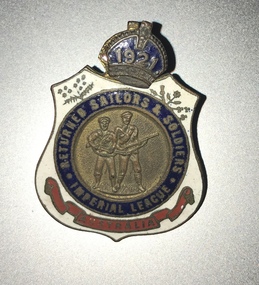
Two member badges from the The Returned Sailors, Soldiers Imperial League of Australia (RSSILA). The number 68 on the front could be 1968 as it is detachable and could be updated each year. The badge with 1921 could be the year of membership. The member number is engraved on the rear. The shield design is symbolic of the protection provided to those who wear it. Within the badge, red represents the blood ties of war that exist between comrades; white stands for the purity of the motives in joining the league – to render service without personal gain or ambition; and blue indicates a willingness to serve a comrade anywhere under the blue sky. The wattle represents Australia, with the leek, the rose, the thistle and the shamrock standing for Wales, England, Scotland and Ireland respectively. The RSSILA was the precursor to the Returned Services League (RSL) and provided support for returned servicemen after World War One. Worn by members of the Returned Sailors, Soldiers Imperial League of Australia, those eligible being members of all services, both wars, including nurses, who have returned from active service outside Australia. These were with other World War 1 memorabilia that has come from Private John Basil McLean, 2nd Reinforcements, 37th Battalion, A.I.F. J.B. McLean (Service No. 13824) was from near Maffra, Victoria and enlisted on 22 January 1916. He embarked on 16 December 1916 for Europe. He spent time with the Australian Field Artillery (Pack Section). At the end of the war he worked for a year at the A.I.F. Headquarters in London before returning to Australia on the 'Ceramic', arriving in Portsea in 1920. His full war record is available from the National Archives of Australia (B2455, MCLEAN JBM).The RSSILA was an important organisation for ex-servicemen and many Legatees would have been members.Enamel badges from the R.S.S.I.L.A. The centre of the badge shows a sailor and a soldier in raised detail. A blue enamel circle surrounds the central detail and has 'RETURNED SAILORS & SOLDIERS / IMPERIAL LEAGUE' in gilt lettering. The outer edges of the badge are white enamel with a floral spray to the top left and right of the blue circle. At the bottom of the badge is a red enamelled scroll with 'AUSTRALIA' written in gilt lettering. On the reverse of the badge are soldered two brass lugs with a split pin attached for securing the badge to clothing. 01124.1 Front has '68' and 'Returned Sailors and Soldiers Imperial League of Australia'. On the reverse 'V92210 Badge remains the property of League'. 01124.2 Front has '1921' and 'Returned Sailors and Soldiers Imperial League of Australia'. On the reverse 'R 3871' and 'C.C Roeszler and Son Pty Ltd Melb.'world war one, rssila -
 Melbourne Legacy
Photograph, Bombay, 1920
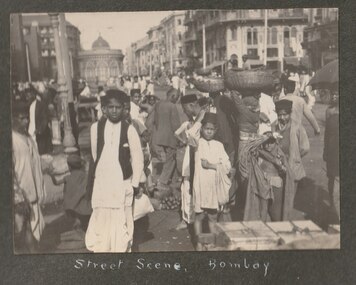
Three photos from an album belonging to JB McLean, of his voyage home from World War 1 in 1920 on the Ceramic. The photos are of street scenes in Bombay, India. They include the Towers of Silence and a cow lying in the street as well as street traders. These scenes would have been unusual for an Australian soldier and made a good souvenir. The visit to Bombay was a stop over point for the Ceramic on it's way to Australia. The Ceramic departed Tillbury, UK 12th March and docked in Freemantle on 27th April 1920 and then went onto Adelaide, Melbourne and Sydney. The Ceramic was a transport vessel built in Belfast in 1913 for the White Star Line to transport frozen produce and apples from Australia to UK. It was taken over by the Australian Government for troop transport in October 1914 and could carry over 3,000 troops. This trip in 1920 there were 1467 on board, there were women and children as well as 439 soldiers returning home, one of whom was John 'Basil' McLean. Was with other World War 1 memorabilia that has come from Private John Basil McLean, 2nd Reinforcements, 37th Battalion, A.I.F. There was a large collection of postcards so he may have been collecting them as souvenirs. J.B. McLean (Service No. 13824) was from near Maffra, Victoria and enlisted on 22 January 1916. He embarked on 16 December 1916 for Europe. His full war record is available from AWM. He spent time with the Australian Field Artillery (Pack Section). At the end of the war he worked for a year at the A.I.F. Headquarters in London before returning to Australia on the 'Ceramic', arriving Portsea in 1920.A collection of items from John Basil McLean is in the archive. Kept as an indication of what founding legatees experienced in World War One and what they saw on the way home.Sepia photo of officers onboard the Ceramic glued to black cardboard in an album of photos from 1920.Handwritten caption 'Baby Show Ceramic' in white ink.souvenir, world war one, jb mclean, ceramic, bombay -
 Eltham District Historical Society Inc
Document, Certificate as to Trustees of Wesleyan Church land, Lot 20 Henry Street, Little Eltham North, 7 Oct 1901
The Trustees for Lot 20 Henry Street were declared by the Wesleyan Methodist Church on 7 October 1901 to be Revd. Barnabas Shaw Walker, Minister of the Pentridge Circuit, Joseph Cooper, Gardener of Keelbundora, Samuel Jeffrey, Farmer of Jika Jika, Francis Thomas, Farmer of Doncaster and sometime of Keelbundora, John Brown, State School Teacher, William John Taylor, Gardener, Robert David Taylor, Gardener and Isaac Hill, Dealer, all of Eltham. Originally purchased in 1856 from Thomas Roberts, Yeoman of Little Eltham, for £10 for use by the Wesleyan Chapel, represented by indentured Trustees, Rev. Barnabas Shaw Walker, Minister of the Pentridge Circuit, Francis Thomas, Farmer of Keelbundora, William Harriman, Blacksmith of Nillumbik, Nicholas Rodda, Farmer of Nillumbik, Aaron Grimshaw, Farmer of Greensborough, Joseph Cooper, Gardener of Keelbundora, Peter Dredge, Scholmaster of Jika Jika and Samuel Jeffrey, Farmer of Jika Jika. Lot 20 of Subdivision of Portion 13, Section 4 of the Parish of Nillumbik in the County of Evelyn was located on the southern side of Henry street in Little Eltham North, where the current Our Lady Help of Christians Catholic Church is situated. It became the location of the Eltham Rechabite Hall. In 1893 a new hall was built and further enlarged in 1919. At the commencement of 1922, the property was purchased from the Independent Order of Rechabites with publicly subscribed funds and a new hall built at a cost of £750 and improved road access constructed to reduce the grade, running from Dudley Street to Henry Street. This hall was eventually replaced with the new Shire Offices and Hall built on the corner of Arthur Street and Main Road, which was opened in 1941. Traces the earliest history of the Eltham Public Hall in Henry Street and the various names, occupations and abodes of the Trustees associated with the propertyeltham public hall, eltham rechabite hall, eltham wesleyan chapel, francis thomas, henry street, james abel marsland, james massland, john brown, joseph cooper, little eltham north, rev barnabas shaw walker, robert david taylor, samuel jeffrey, trustee, william john taylor, little eltham, isaac hill -
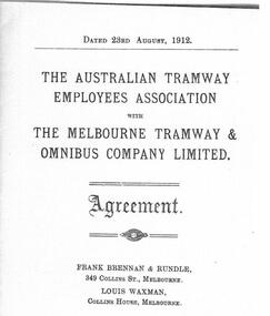 Melbourne Tram Museum
Document, Agreement - 1912 - between ATEA and MTOCo
Digital image of a photocopy of the Agreement dated 23-8-1912 between the Australian Tramway Employees Association with the Melbourne Tramway & Omnibus Company Limited and a supplemental agreement dated 12-8-1913. The agreement was the first between the Union and the Company which had long resisted unionism. The Victorian Branch of the ATEA was formed in November 1910. The agreement was the result of an Arbitration hearing before the Commonwealth Conciliation Commission. Frank Brennan & Rundle represented the Union and Louis Waxman the Company. The agreement covers wages for all the Companies employees, working days, rostered days off, travelling time, meal breaks, rosters, Sunday work, exchange of shifts, public holiday rates, training of students, accident reports, ability to wear their union badge on their watch chains, disputes re revenue, trackmen, ropemen, the establishment of a Board of Reference, dispute resolution, breach of the agreement and expiry - 30 June 1916, the day the Company Franchise ended. See item 7361 for a copy of the MTOCo employee rules that reflect this agreement. Signed by L L Hill Union President, A C Warton Union Secretary, H A Wilcox Company Secretary, and W G Sprigg, one of the Company Directors. The supplemental agreement - has a long introduction to the dispute regarding workers being represented on the grounds of alleged misconduct. Notes the name of the Court President, Mr. Justice Higgins. Provides the process for representation of any man who is accused of misconduct, discipline, and proof of the charge. Notes the use of the company's private (detective) staff - known as spotters. The wearing of union badges was the cause of a large General Strike by tramway men and others during 1912 in Brisbane. See item 8472 for a book containing the agreement and annotations for each section.Yields information about the first agreement between the Melbourne cable tram operator and the Union that represented the workers. Digital Image of the 1912 Agreement between MTOCo and the ATEA and a supplemental agreement of 1913tramways, trams, unions, atea, mtoco, cable tramways, employment conditions, agreements, cable trams, disputes, discipline, spotters -
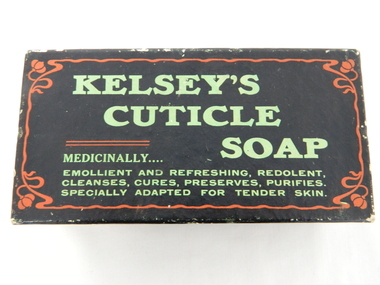 Kiewa Valley Historical Society
Box Cuticle Soap, mid to late 1900's
The mid 1900's provided the start of "the body beautiful" revolution. The cosmetic industry, with the help of quasi scientific selling advertising slant targeted those "customers" that needed the "extra care" factor that only their product could offer. At this period in time their advertising power was based on in store, radio and newspaper media channels with saturation levels relatively low. In the later years of the 1900's saturation levels and a wider range of products and increased competition further increased the product saturation levels available to the buying residents. With the introduction of television the advertisements become more elaborate and "catchy" words, phrases and comedy type situations helped boost the advertising "pitch" and subliminal undertones to effective levels required for a highly competitive health related market place. 'sellingThis subliminally,"medically" endorsed product was one of many during the great "spin" revolution of product marketing and selling. This item is significant in that it demonstrates that greater infusion of product awareness throughout rural areas was highly successful through a greater variety of advertising media. It also demonstrates that in a highly competitive marketplace there are no physical boundaries that impinge upon the distribution of products and services. The rural sector is a highly lucrative region for any product that helps protect the body from all the "nasty's" that become more noticeable in a rural environment. This rectangular box which had contained cuticle soap is constructed from cardboard and reinforced by a black nylon impregnated sheeting. This impregnation was required to keep the box from soaking up any water from the user's hands. The top section of the box(lid) has and in large print "KELSEY'S" top line followed by "CUTICLE" off to the right and underneath and to the right "SOAP". Below this and in smaller print is "MEDICINALLY..." below this and in smaller print "EMOLLIENT AND REFRESHING, REDOLENT, CLEANSES, CURES, PRESERVES, PURIFIES." and last line underneath "SPECIALLY ADAPTED FOR TENDER SKIN" On each of the sides of the top lid are, side 1 "INVALUABLE FOR THE NURSERY." underneath in smaller print "JOHN M. KELSEY CO." to the left of this and on a green backed highlighter "No. 1744 - Guaranteed under Pure Food Act, 1908, N.S.W. by John M. Kelsey Co. - No. 1744. Melbourne, Victoria." On the right side and in large print "KELSEY'S CUTICLE SOAP" on the next side and also a similar sign on the opposite side "SPECIALLY ADAPTED FOR TENDER SKIN." below this "JOHN M. KELSEY CO." "Registered" and on the other long side in large print "SPECIALLY ADAPTED FOR TENDER SKIN" underneath in smaller print JOHN M. KELSEY CO. Registered"specialised soap, toilet requisites, nursery health., bathroom, domestic -
 Victorian Aboriginal Corporation for Languages
Conference proceedings, Joan Argenter, Endangered languages and linguistic rights on the margins of nations : proceedings of the Eighth FEL Conference : Barcelona (Catalonia) Spain 1-3 October 2004, 2005
Section 1: Grass-roots Efforts and Top-down Institutions Keynote Address: Leanne Hinton The Death and Rebirth of Native American Languages Patrick Marlow Bilingual Education, Legislative Intent, and Language Maintenance in Alaska Galina Dyrkheeva New Language Policy and Small Languages in Russia: the Buryat Example Zelealem Leyew The Fate of Endangered Languages in Ethiopia Gregory Hankoni Kamwendo Language Planning from Below: Chitumbuka as a Marginalised Language in Malawi John Hobson Learning to Speak Again: Towards the Provision of Appropriate Training for the Revitalization of Australian Languages in New South Wales Shelley Tulloch Grassroots Desires for Language Planning in Nunavut Amandina C�rdenas Demay Hacia la definici�n de una pol�tica del lenguaje & Alejandra Arellano Mart�nez expl�cita en M�xico Elena Benedicto, G. McLean, Linguistic Rights in the Nicaraguan Atlantic Coast: Grupo de Ling�istas Ind�genas Mayangna Actions on the Ground within the Legislative Framework of the Estatuto de Autonom�a Bartomeu Meli� Las lenguas ind�genas en el Paraguay. Una visi�n desde el Censo 2002 Monica Ward Building from the Bottom-up: Linguistic Rights for Extremely Endangered Languages Marta Moskal Language Policy and Protection of Endangered Languages in Poland Sue Wright What is a language? Some difficulties inherent in language rights Joan Ramon Sol� Obstacles in the Way of the Recovery of Catalan Section 2: The Global vs. the Local in Linguistic Rights Keynote Address: Patxi Goenaga Fronteras que dividen y fronteras que separan. Una mirada a Europa desde el Euskara Yun-Hsuan Kuo Languages, Identity, and Linguistic Rights in Taiwan Estibaliz Amorrortu, Andoni Barre�a, What Do Linguistic Communities Think about the Esti Izagirre, Itziar Idiazabal, Bel�n Uranga Official Recognition of their Languages? Alok Kumar Das Linguistic Practices and Not Just Linguistic Rights: Endangered Languages in New Europe Section 3: Languages crossing the Borders Keynote Address: Tjeerd de Graaf The Status of Endangered Languages in the Border Areas of Japan and Russia Mariana Bara Arm�n endangered language Ver�nica Grondona Language Policy, Linguistic Rights and Language Maintenance in Argentina Grup d?Estudi de Lleng�es Amena�ades Linguistic diversity in Catalonia: towards a model of linguistic revitalization Nataliya Belitser Endangered Languages in Crimea/Ukraine: The Cases of Crimean Tatar, Karait, and Krymchak Ivelina Kazakova & Maria Miteva The Future of Bulgarian: The Road to Extinction or Paradise Regained Luke O?Callaghan War of Words: Language Policy in Post Independence Kazakhstan Eden Naby From Lingua Franca to Endangered Language: The Legal Aspects of the Preservation of Aramaic in Iraq Poster presentations Akim Elnazarov Endangered languages and Education. A Case of Badakhshan Province of Tajikistan Arnfinn Muruvik Vonen & Oddvar Hjulstad Linguistic Rights Paving the Way Towards Language Endangerment? The Case of Norwegian Sign Language Eva Savelsberg Kurdish (Kurmanc�) as Minority Language in the Federal Republic of Germany Jos� Antonio Flores Farf�n Cultural and Linguistic Revitalization, Maintenance and Development in Mexico Mary Jane Norris Assessing the Status, Use and Accessibility of Canada?s Aboriginal Languages within Communities and Cities: Some Proposed Indicators Michael Prosser van der Riet Promotion of Minority Language Scripts in Southwest China. A Relative Success or Complete Failure? Mikael Grut The Endangered Celtic Languages: A Wake-up Call Nariyo Kono Developing Partnerships Between Universities and Language Communities: Top-down and Bottom-up Integration Richard J. Hawkins Probit Modeling Language Attrition Rudy Osiel Camposeco El idioma maya Popti? y la Declaraci�n Universal de los Derechos Ling��sticos Victorio N. Sugbo The literary Response: Claiming Rights in Three Philippin Languages Ya-ling Chang Language Policies in an Aboriginal Primary School in Taiwanmaps, tables, graphsnsw, endangered languages, linguistic rights -
 Bendigo Historical Society Inc.
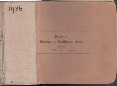
Book - RIGHT TO OCCUPY RESIDENCE AREA COLLECTION: REGISTER 1936
COLLECTION OF RIGHT TO OCCUPY A RESIDENCE AREA -LAND (RESIDENCE AREAS ) Act 1935 / thick cardboard book -cloth and string binding / written on front in texter '1936' / numbers 901 to 1000 / inside - stubs of documents showing Granted to, of, period, Date of Right , Description of Land, Allotment, Section, City, Town, Borough, Township of, Parish of, Authorised Person . Rubber stamps show The interest of this Right has been transferred to / stub 905 has the relevant document attached stating RIGHT TO OCCUPY A RESIDENCE AREA . Know all men that I, the undersigned , being in that behalf duly authorized by the Governor of the State of Victoria , DO HEREBY , in pursuance of the Land (Residence Areas ) Act 1935 , and in consideration of the payment of an occupation fee of FIVE SHILLINGS, GRANT To. Of a RIGHT TO OCCUPY AS A RESIDENCE AREA the land herein specified , for a period of one year from subject to the conditions of the conditions set out on the back thereof. Authorised Description of land / the reverse of the document gives the CONDITIONS- (SEE RESEARCH FOR DETAILS//// note on Bendigo Historical Society Catalogue Sheet dated 12.6.2008 All butts completed and original application forms removed . Note -forms were originally in triplicate on one page with serrations for removal of two parts; butts remain .Residence areas in Central Goldfields.Bendigo City Council - Acquisition 1990organization, government, bendigo land office, right to occupy a residence area -land (residence areas ) act 1935/ -
 Bendigo Historical Society Inc.
Clothing - AILEEN AND JOHN ELLISON COLLECTION: FLORAL DRESS
Pink, purple, green and grey floral patterned dress. Rayon fabric with smooth surface. Sleeveless bodice with wide shoulder straps. The shoulder straps widen from 6cm at the front across the shoulders to attach at either side of centre at 14cm. Back of the bodice is made of four straight pieces from waist to above bust line. The front of the bodice is made from three pieces with centre piece dipping. Narrow at front because gathered in to U shape at centre front at waist. Across the bust line are two pieces of fabric with horizontal folds to create fullness. The pieces are joined at centre front with a decorative knot of fabric. The bodice and shoulder straps are lined with cream coloured net. Two darts at front and two at back from waist. The full length skirt is made from two pieces at the front and the back is made from four pieces. Back of the bodice inverted at skirt. Back opening at centre back with 26cm metal zipper. Hook and eye above zipper. On either side of centre back are two folded pieces of gathered fabric attached at waistline to create the effect of a large bow with tails. Attached at the waist on each hip are two padded sections of fabric 39cm x 10cm, gathered at waist.costume, female daywear, dress -
 Bendigo Historical Society Inc.
Document - ALBERT RICHARDSON COLLECTION: SECRETARY FOR MINES ANNUAL REPORT 1911
Three page typed report titled ' Notes on diagram showing pitch lines, Bendigo'. Longitudinal sections along the lines of reefs or anticlines within the 8 mile block at Bendigo are shown in a diagram' (diagram not included with notes) Mines and reef lines mentioned in the report are : New Chum line, New Chum Railway mine, Catherine United mine, Hercules and Energetic mine, Garden Gully, Hustlers and Redan, Sheepshead Reef, Sea Mine, Garden Gully, Miller's line of reef and Bendigo Development Mine. The 'old stacks' or chimneys, on Bendigo are described. 'Among the earliest of the stacks built at Bendigo in connexion with Quartz crushing plant, are the two figured in this Annual report No 1 was situate in Sailor's Gully but was demolished about three years ago. This, if not the first, must have been one of the first built, for it had a stone inserted on which chiselled the date 1854. It was built altogether of rough masonry. The other, No. 2, is still standing at the Sheepshead line and was apparently of later date, the upper portion being of brick. They are intersting landmarks of an era that is rapidly passing.' Map attached to report showing location of stacks. Stack at Sailors Gully was near the corner of Murchison Street and Lester Street. The stack at Sheepshead ( Deborah Triangle area) was near the intersection of Belle Vue Road and Adam Street.bendigo, mining, pitch lines bendigo -
 Ballarat Tramway Museum
Administrative record - Log book, Diary, Sands McDougall Pty Ltd, 1958
Yields information about the track maintenance activities of the track gang in Ballarat, the work they did, notes, names and other information.Invicta Australian 1959 Business Diary, No. 4, printed by Sands and McDougall, light grey Rexene binding strip, card covers, sewn sections with ruled sheets providing a diary for 1959, one week per double page. Has "useful information" sheets at from the diary. Used by the SEC Ballarat track gang to record their daily work, leave, welding, track cleaning, truck driver etc Rear pages - has notes on materials used, costs, scrubber use and hours, and length of track On the inside of the rear cover is a list of Track gang and addresses for 1959. W. H. Goldsmith H. Dowie S. Eaton W. Newell E. Lakey J. Armstrong J. Naus C. Edwards A. W. Cunningham H. Lancaster H. Smith Loose contents 18/5/1059 - Medical Certificate for S. Eaton - dated 9/10/1959, Dr. D. P. Podger 28/12/1959 - Daily time sheet with track work notes Inside rear cover Begonia Festival 1959 brochure SEC Workshop Requisition Misc. notes List of Staff and address - J. Naus added to above list. List of track lengths re top dressing between various lengths.tram, trams, sec, ballarat, depot, trackwork, rails, scrubber tram -
 Ballarat Tramway Museum
Postcard - Folder set, Nu-color-vue or Nucolorvue Productions, "A Souvenir of Beautiful Ballarat", late 1940's
Set of 12 coloured views of Ballarat printed with six photos on either side of a folded strip of paper glued within an embossed paper folder. Published by Nucolorvue Productions Vic., titled "A Souvenir of Beautiful Ballarat". Front cover has a colour rural scene, title, address area and on base of cover "12 Specially Selected Views in Full Colour". Rear of Cover has a part of a colour scene as well and a slit for the envelope to be closed over and sealed. On the inside of the front cover are notes on the City of Ballarat and that it has just embarked upon its second century. 1. Another section of Ballarat's Fine Botanical Gardens 2. Overlooking Ballarat City 3. Botanical Gardens showing statues of Australian Prime Ministers 4. Sturt Street showing City Hall and Fine Statues 5. Lake Wendouree Ballarat 6. Lovely Trees and Statuary Botanical Gardens 7. Botanical Gardens showing Wallace's Statue 8. Lovely Sturt St looking West 9. Overlooking Sturt St towards Mt Warrenheip (has single truck tram in photo) - see image i9 for a hi res version. 10. Ballarat's Famous Art Gallery 11. One of Ballarat's many fine Reservoirs 12. Eureka Stockade Monument, Ballarat. On front cover in pencil in stamp area "1/-"trams, tramways, ballarat, postcards, sturt st, bridge st, gardens