Showing 17159 items matching "bay-bridge"
-
 Melbourne Tram Museum
Document - Report, Prahran & Malvern Tramway Trust (PMTT), "The Prahran and Malvern Tramways Trust - Report and Statement of Accounts, Nov. 1918
Photocopy of Report - 32 foolscap pages - titled "The Prahran and Malvern Tramways Trust - Report and Statement of Accounts for Twelve Months ending 30th September 1918". Gives listings of Trust Members and Officers, lines opened, Rollingstock, power supply problems, Finance, Operation and General matters, statistics, finance statements, balance sheet and Auditors Report. Appendices includes the Engineers and Manager's Report, Statistics, accounts, funding, auditor reports and maps. Also covers concession fares for soldiers, purchase of tyre, battery maintenance, traffic at Victoria St bridge, Honor boards, arbitration and land for a storage site. Lists names of Employees who volunteered for active service, including those who volunteer but did not pass the medical test. Audited by Percy P Cook. See htd2389i2.pdf for the listing of those who served in WW1Has the stamp of the Tramway Museum Society on the rear of the first page.trams, tramways, pmtt, reports, construction, finances, operations, horse trams, tourist tickets, world war 1, unions -
 Melbourne Tram Museum
Pamphlet, Yarra Trams, "Your new accessible tram stops", Apr. 2007
Set of five Pamphlets - DL - 3 fold, full gloss paper titled "Your new accessible tram stops" about the introduction in April 2007 of upgrades stops in Burwood Highway - stops 59, 61, 62, and 63 to Superstops. Has VicRoads logos as well as Vic Government and Yarra Trams. Two copies held. 1 -2 fold DL - for stops 124A on routes 96, 109, and 112 - on the Specert St Bridge over the Yarra River - has map. 2 - 3 fold DL for stops 38, 42, 48 and 52 Dandenong Road - Nov. 2007 3 - 3 fold DL for stops 22, 23, 24 and 26 Queens Parade Fitzroy North, Nov. 2008 4 - 3 fold DL for stops 53 to 59 - Matthews Ave Airport West April 2008trams, tramways, yarra trams, burwood, vermont south, superstops, route 75, spencer st, route 96, route 109, route 112 -
 Melbourne Tram Museum
Pamphlet, Minister of Transport, "Transport Victoria", 1977 and 1978
453.1 - Sixteen page, full colour printed on glossy paper, centre stapled pamphlet, titled "Transport Victoria", with part of the Harold Freedman on the front cover, detailing the structure and the authorities of the Ministry of Transport, c1977. Foreword by Hon. J. Rafferty Transport Minister (1976 to 1978 - State Parliament website biography). Provides information on: MMTB Victorian Railways - VicRail Railway Construction Board Melbourne Underground Rail Loop Authority - MURLA Country Roads Board - CRB Transport Regulation Board - TRB Westgate Bridge Authority and who's who in the transport in Victoria - Board members - with photos. 453.2 - as above but with foreword by Robert Maclellan MLA as minister (see image 9) and revision of the "Who's who" on page 15 - see image 10. Maclellan was the Minister was 1978 to 1982 - parliamentary web site. Not imaged..trams, tramways, mmtb, minister for transport, vicrail, crb, murla -
 Melbourne Tram Museum
Photograph - Set of 11 Colour Print/s, Bill Davis, mid 1980's to 1990
Set of 11 colour prints of Melbourne trams and locations during the mid 1980's to 1990, Photos not well focused. .1 - trams 782, 259 and 2002 out the front of South Melbourne Depot .2 - 979 and 888 at ditto .3 - 888 .4 - 975 and two other W's at Preston Depot .5 - 2001 - Burwood Road on a Special, near Hawthorn Bridge. .6 - ditto .7 - 968, Kingsway, South Melbourne near Sturt St .8 - 861 ditto .9 - 881 outbound St Kilda Road .10 - 900 and W2 442 (Restaurant tram 1) at Acland St terminus. .11 - 913, inbound Glenhuntly Road, on the east side of Glenhuntly Station. Features advertisements on trams for: Triple FM Radio, Bank of Melbourne, Space Deamons Printed on Kodak, Fujichrome or Konica paper.trams, tramways, ptc, south melbourne depot, preston depot, burwood rd, kingsway, st kilda rd, acland st, glenhuntly rd, tram 782, tram 259, tram 2002, tram 2001, tram 979, tram 888, tram 975, tram 968, tram 861, tram 881, tram 900, tram 442, tram 913 -
 Eltham District Historical Society Inc
Document, Russell Yeoman, Tour of Historic Buildings and Locations, 1978
Self guided heritage tour information produced by the Shire of Eltham Historical Society for 1978 Eltham Community Festival of 36 locations each numbered on accompanying map. Locations and detail provided current to 1978: 1. ELTHAM SHOPPING CENTRE Whilst very little remains in the centre of historical importance, this area has interest as the "village" which developed over many years following the opening of the railway from Melbourne in 1902. Previously the shopping centre had been spread out over a long length of Main Road to the south. Shops have been continuously demolished or remodelled and the majority of buildings date from the 1950's or later. The recently erected Post Office replaced the "old" Post Office opened on the same site only in 1958. 2. WOOLWORTHS ELTHAM VILLAGE Part of the site of this modern shopping development was occupied by the former Eltham Shire Offices and Hall. The hall was paid for by public subscription whilst the Council raised a loan for the offices. The combined building was opened in 1941. It served as office and Council meeting place until 1965 and as the hall until its demolition in 1970. 3. ELTHAM WAR MEMORIAL The complex of buildings adjoining the present Shire Offices were financed by public subscription as a Memorial following World War II. Their construction and for many years their operation was organised by the now disbanded Eltham War Memorial Committee. The original buildings were the; Infant Welfare Centre, Children’s Library (now War Memorial Hall and Dental Clinic) and Kindergarten. In later years the Elderly Citizens Club was built at the rear. 4. ELTHAM SHIRE OFFICES These offices were opened in 1965 and extended in 1971 to provide additional office accommodation and the Eltham Library. They represent the last of a long line of offices and meeting places of the Eltham Shire Council and its predecessor the Eltham District Road Board. The building occupies the former site of Shillinglaw Cottage. The three tall cypress trees which stood in front of the Cottage have been retained as a feature of the office surrounds. 5. OUR LADY'S CHURCH AND SCHOOL The Catholic Church and School complex opposite the Shires Offices shows a number of stages in the development of Eltham township. The recently constructed church adjoins its predecessor (now the parish centre). Many years ago the Catholic Church was located opposite Wingrove Park and the present central site follows the northerly drift of the township. 6. SHILLINGLAW COTTAGE The Cottage was built in 1859 by George Stebbing, a local builder who was responsible for a number of other prominent buildings in the area. Its removal from the site of the Shire Offices and re-erection on the present site was financed by public subscription. It is built of handmade bricks laid in Flemish Bond with an unusual design featuring burnt "leader" bricks over the whole facade. The Cottage is occupied by Eltham Fleececrafts and will be open during the Festival and at other times during weekends. It is classified by the National Trust. 7. RAILWAY BRIDGE The timber trestle bridge over the Diamond Creek was built in 1901. Whilst all of its timbers have been replaced at various times over the years the only change to its character has been the addition of pylons and wiring for electric trains in 1923. It is one of very few similar bridges remaining in the metropolitan area. In 1976 a proposal to replace the bridge with an earth embankment and large culvert pipes was abandoned following community protests. The bridge, however, remains under threat because of the necessity for future deuplication of the railway line. 8. ELTHAM CENTPAL PARK The area between the railway and the creek has for many years been used as a park which included Eltham' s main football oval. The access road, Panther Place is named after Eltham's team playing in the Diamond Valley League. In recent years a large area extending to Bridge Street and locally known as the Town Park has been landscaped and added to the area. The excellent blending of the park with the natural landscape of the creek valley has earned a National Trust Landscape Classification. 9. OLD BAKERY On the southern corner of York Street and Main Road is an old house with a shop front which was for many years the local baker's shop. The brick bakery at the rear is of somewhat later vintage than the house. 10. BRIDGE STREET CUTTING Before reconstruction of Main Road this intersection had deep cutting embankments on all four corners, forming a distinctive feature of the entrance to Eltham. Roadworks and private development have levelled the land on the low side of the road. A memorial to the Eltham soldiers of World War I which was located at the north-western corner is now situated at the Eltham R.S.L. 11. HILLTOP MILK BAR For many years this was the site of the Eltham Post Office under the control of the Hunniford family and later their descendants the Burgoynes. It was transferred to this site in 1855, although at that time the building apparently fronted Bridge Str e et. The site contained Eltham's first telephone exchange. The post office was relocated in 1954 but the shop was operated until recently by the Burgoyne family who still own the surrounding land. 12. UNITING CHURCH and former C.B.A. BANK The former Methodist Church was built in 1880 by George Stebbing. The Sunday School extension was built in 1929 and there have been more recent extensions. The adjoining opportunity shop was built as a bank in 1874 and purchased by the Methodist Church in 1954. 13. R.S.L. HALL, TELEPHONE EXCHANGE These relatively recent buildings occupy the site of a row of shops forming part of the early ribbon of business development along Main Road. In front of the R.S.L. building is the World War I Memorial relocated from the corner of Bridge Street and Main Road. 14. ELTHAM COMMUNITY CENTRE Australia's first mudbrick "community building" was opened in April this year. Part of the site of the building was purchased in 1856 by Henry Dendy (of Brighton fame). At the rear of the land near the creek was a steam flour mill whilst Dendy's house was at the Main Road frontage of the land. His purchase totalled about 2 Ha (5 acres) and included land on the opposite side of Maria Street (Main Road). Dendy became a prominent member of the Eltham community and served one term as President of the Eltham District Road Board. In 1867 Dendy sold his land and business to William Ford of Malmsbury and shifted to Walhalla. The avenue of trees leading past the Community Centre to the creek may well have bordered the track to the mill. 15. ELTHAM HOTEL The original part of this hotel was built in 1927 following the burning of the former Watson's Eltham Hotel on the same site. The car park on the opposite side of Main Road was also the site of a hotel variously known over the years as; the Fountain of Friendship, the Fountain and the Evelyn Arms. As the Fountain of Friendship it was the first meeting place of the Eltham District Road Board in 1856. 16. ST. MARGARET'S CHURCH, PITT STREET In 1860 Henry Dendy was appointed Chairman of a committee to establish a church of England in Eltham. He donated part of his land in Pitt Street and in 1861 the church was opened. It was built by George Stebbing and remains in a well preserved state today. Th adjoining old vicarage is now named Dendy Hou se. A new mudbrick church hall is under construction on the site. The church and Dendy House are now listed on the Register of Historic Buildings. 17. NO. 86 PITT STREET Cottage built by George Stebbing and believed to be his home for some years in the 1850s. 18. LIVING AND LEARNING CENTRE The house was built in the 1850s with the kitchen at the front being added about 40 years later. By the creek below the house a number of early Eltham industries were located. These included a tannery and a brewery. 19. ELTHAM COURT HOUSE A Court of Petty Sessions was established in Eltham in 1858 and the present building dates from 1860. It is the oldest public building remaining in Eltham. In its early days the building was used as the meeting place and office of the Eltham District Road Board and as an overflow classroom for the local school. The Court House has been classified by the National Trust. The citation states that it is an example of the simple form of early brick Court House with gabled roof and porch. 20. LANDS DEPARTMENT OFFICE This building is the former police station and is probably of about the same age as the Court House. The lockup at the rear has been demolished but the old stables remain as garages. A licence was first granted for a police station at Eltham in 1856. 21. JARROLD COTTAGE The old Cottage opposite Dalton Street was formerly owned by the Jarrold family. Early records indicate that this was the building leased from the Jarrolds as a temporary police station prior to construction of the building on the corner of Brougham Street. The small building on the corner of the property was used as a boot repairer's shop. The elevated studio at the rear is a more recent construction by the present owners. 22. STATE SCHOOL RESIDENCE Erected in 1891 23. WINGROVE COTTAGE This building fills an important place in the history of Eltham and is now used as a medical clinic. It was built in 1858 for Charles S. Wingrove who was Secretary to the Eltham District Road Board and Shire Council from 1858 to 1904. During part of this period he was also Shire Engineer and was Secretary to the Heidelberg Road Board. The house was used as the office of the Board and Council for many years. Wingrove is buried in the cemetery at St. Helena. 24. WINGROVE PARK The parkland opposite Wingrove Cottage has been named after Charles Wingrove. The old Manna Gums are an outstanding feature of the park. 25. ELTHAM FRI.MARY SCHOOL NO. 209 The school first opened in the slab building in 1855 and operated from the present site since 1857. The oldest part of the present school is the stone building erected in 1876. The first school teacher, David Clark remained at the school until 1888. This school is the government township and has always been known as the Eltham School. An earlier school (no.371) known as Little Eltham School operated in Swan Street from 1853 to 1872. 26. "SHOESTRING" This house was built for school teacher David Clark. It has been extensively extended in recent years but the extensions do not detract from the character of the older part of the building. 27. ELTHAM CEMETERY The cemetery contains the graves of many of the district's pioneers . 28. MONTSALVAT This unique complex of buildings was commenced in 1935 by the late Justus Jorgensen and its development has extended over many years. Montsalvat has exerted a significant impact on Eltham The earth and stone construction of many of the buildings has influenced local architecture to a great extent and it has served as a "nerve centre" of the local artistic community. Montsalvat is open to the public for a small charge. 29. MAIN ROAD BRIDGE This location has been the main crossing of Diamond Creek since the earliest days of settlement. The present concrete bridge was erected in 1925 .and was preceded by a number of timber bridges. 30. ELTHAM LOWER PARK This park, being an unusually large flat area for Eltham, was originally the local racecourse. Horse races were held here from 1855 and the area was gazetted as a reserve for a racecourse and recreation reserve in 1857. The park is well known as a venue for school "bird days" and more recently as the site of the Diamond Valley Railway. This miniature railway features scale models of modern and old locomotives and rolling stock and has operated on this site since 1961 . Before that the railway operated at Chelsworth Park, Ivanhoe. 31. FALKINER HOUSE Frederick Falkiner was one of the earliest settlers in the Eltham township area and occupied a substantial leasehold prior to the first land sales. Early records show that Falkiner was the subject of a number of complaints from his neighbours but he has nevertheless been considered a prominent enough citizen to have a street named for him. This house was the home of Evelyn (Ely) Falkiner a member of Frederick's family. 32. WEST HOUSE Behind the large house on the hill is an early house built by the West family. This was relocated from a site near the front of the land by the present owner Mr. Fabbro. 33. FALKINER HOUSE This very old house is believed to have been the home of Frederick and may have been Eltham's first post office. Falkiner was the first post master for a short period. in 1854/55. 34. WITHERS HOUSE This house was the home of famous artist Walter Withers who shifted here from Heidelberg in 1903. 35. ELTHAM HIGH SCHOOL This school celebrated its jubilee this year, having commenced as the Eltham Higher Elementary School 50 years ago. 36. DIAMOND CREEK FOOTWAY If returning from the High School to the town centre the footpath by the bank of the Diamond Creek provides a pleasant route to finish your walk. The creek is a major tributary of the Yarra River. Together with its own major tributaries Arthurs Creek and Running Creek it commences on the southern slopes of the Dividing Range at Kinglake. It gives the name Diamond Valley to an area extending well beyond its actual drainage catchment.Recognition of the significance of various landmarks to the history of the Eltham community as of 1978‘shoestring’, 1978, bridge street cutting, burgoyne store, c.b.a. bank, diamond creek trail, eltham cemetery, eltham central park, eltham community centre, eltham community festival, eltham court house, eltham festival, eltham high school, eltham hotel, eltham lower park, eltham primary school, eltham railway trestle bridge, eltham shire offices, eltham shopping centre, eltham state school no. 209, eltham village, eltham war memorial, falkiner house, heritage trail, hilltop milk bar, jarrold cottage, lands department office, living, living and learning centre, main road bridge, montsalvat, old bakery, our eltham artistic recollections, our lady help of christian’s church, our lady help of christian’s primary school, pitt street, post office, r.s.l. hall, shillinglaw cottage, st margaret’s church, state school residence, stebbing cottage, telephone exchange, uniting church, west house, wingrove cottage, wingrove park, withers house, woolworths -
 Bendigo Historical Society Inc.
Document - CONNELLY, TATCHELL, DUNLOP COLLECTION: ACCOUNTS ESTATE OF ESTHER ISABELL CANNING, 1893 -1894
Document. Accounts of Estate of Esther Isabelle Canning. 1 - 1894 - Account from Hinchcliffe Edwin, M. D., View Street Bendigo. 2 - 1894 - Account from Jones T R, Chemist & Druggist, Hargreaves Street, Sandhurst. 3 - 1894 - Ac. From William Bruce & Sons, B. B. Brewery, Bridge St. Bendigo, Brewers, Aerated Waters and Cordial Manufacturers, 2 April 1894. 4 - 1894 - Ac. From William Bruce & Sons, B. B. Brewery, Bridge St Bendigo, Brewers, Aerated Waters and Cordial Manufacturers. 1 March 1894. 5 - 1893 -Ac. From Burt, E Mrs, Nurse. 6 - 1894 - Receipt from Phoenix Fire Office of London, Victorian Branch, 60 Market St, Melbourne. Insurance from Fire for Property - Cottage, High St. 7 - 1893 - Receipt from Phoenix Fire Office of London, Victorian Branch, 60 Market St, Melbourne. Insurance from fire for property - Hotel, high St. 8 - 1894 - Ac from S. P. Co-Operative Co, Mitchell St, Bendigo, General Grocers, Tea and Provision Merchants. 9 - 1894 - Ac from Forbes T, Surveyor, View St, Bendigo. Subdivision of Allotment 5, Section 29A at Golden Square. 10 - 1893 - Ac from Mackay & Co, Bendigo Advertiser Office, Market Square, Bendigo. 11 - 1893 - Ac from Pritchard Geo, Aerated Water and Cordial Manufacturer, Arnold St Bendigo. 12 - 1893 - Receipt from McKenzie R C. 13 - 1894 - Ac from C H Hobson & Co, General Auctioneers, Bendigo Arcade Auction Rooms, Hargreaves St Bendigo.cottage, miners, connelly, tatchell & dunlop, hinchcliffe edwin, jones t r, william bruce & sons, b b brewery, burt e mrs, phoenix fire office of london, s p co-operative co, forbes t, mackay & co, bendigo advertiser office, pritchard geo, mckenzie r c, hobson c h -
 Bendigo Historical Society Inc.
Photograph - HILDA HILL COLLECTION: BLACK AND WHITE PHOTOS, 1923
Series of Black & White Photos Total 4 depicting post war life for the Hill Family & Friends. The Hayes' Family Buick, 4 occupants and two men standing on offside of vehicle, two men in front seat are wearing dark suits and hats, two ladies in rear seat wear dark clothing, one has a hat, man standing beside the car in dark suit white shirt and black tie, other man nearer the back is wearing a grey suit, wooden cross in background near rear of vehicle, trellis fence left background, short white picket fence right background, 'Durvol'. This photo has two men in the front seat, both wearing grey suits white shirts and black ties, driver only wears a hat, in the rear seat are two ladies wearing dark clothing, one wears a hat, and a male wearing a dark suit white shirt and dark tie, Note anti kick guards below each door. At Hanging Rock family group, three gentlemen one lady and two young girls, standing next to a road bridge with wooden railings, two males are dressed in dark suits white shirts and dark ties, one wears a hat, man sitting on bridge rail wears a grey suit white shirt and dark tie, the two young girls are wearing light coloured clothing. Martin, Jack, Tom & Dolly the Horse, three boys wearing dark clothing, two boys are wearing white shirts and dark ties, Dolly is dark coloured, background shows gable roofed house with one chimney, end of veranda , large tree left background, wooden paling fence, 'Durvol' property Kyneton 1923.Hilda Hill Pesdonal Collectionaustralia, history, post war life -
 Melbourne Tram Museum
Slide - Set of 7, Keith Caldwell, 17/06/1971 12:00:00 AM
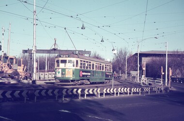
Set of seven Agfa colour slide, blue and white plastic mount, photo by Keith Caldwell of a track deviation during the construction of the Alexandria Avenue underpass at the north end of St Kilda Road. Shows the deviation, temporary track ("on the fly), overhead works and after the bridge has been completed, the permanent track brought into use.. All have the Arts Centre in the background. Slides 1 to 4 - 17/6/1971, 5 to 7 - 20/6/1971, after the change over from the temporary track to the permanent track. .1 - W6 919 outbound, East Malvern Route 3 - has a large gantry beam in the background and an advertisement for briquettes and Norton Bear tape. In the background is the National Gallery of Victoria building. .2 - W2 819 outbound, route 8 Toorak, with Shrine of Remembrance in the background. .3 - W2 389 ditto for Glen Iris, Route 6 .4 - W2 349 outbound for East Brighton, route 64 and inbound W2 633, city, route 67. .5 - SW6 854 inbound using the new track on the bridge, but temporary track remains in front of the tram. Overhead crews at work. W5 768 following. Both trams are travelling on the wrong line or "bang road" Tram have a Stillwell Ford and Ferris Car radio adverts. .6 - SW6 905 inbound, route 67. Also running wrong line. In the background is a rail mounted overhead trolley tower and Bedford truck MZR129. .7 - SW6 845 in bound route 8 followed by SW6 854, route 72. Both trams are running on the wrong line. An excavator in the background is working on removing the deviation track. 845 has various adverts including one for Uniroyal Tyres..1 has in pencil "17.6.71" and "Alex Av Opass constrn" and .7 "20.6.71"trams, tramways, st kilda rd, temporary track, trackwork, overhead, alexandra ave, princes bridge, bridges, route 3, route 67, route 64, route 8, route 6, route 72, w6 class, w2 class, tram 919, tram 905, tram 819, tram 389, tram 349, tram 633, tram 854, tram 768, tram 845, tram 854 -
 Melbourne Tram Museum
Slide - Set of 7, Keith Caldwell, 10/03/1960 12:00:00 AM
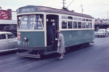
Set of 7 Agfa Colour slide, cardboard mount, by Keith Caldwell of 10 March 1960 - .1 - X2 677 - at the Williamstown Road terminus of the Footscray tram system. Tram photographed in Somerville Road, showing the return destination of Russell St. In the background are a row of shops. .2 - X1 460 turning from Leeds St into Barkly St. Tram has the destination of Ballarat Road. In the background is the bus stop and tram stop and the Trocadero Theatre side wall. See Image i6 for the Theatre. Has a Gant Motors advert. .3 - X1 467 out bound turning into Nicholson St from Irving St. Footscray with the Rockmans Store in the background. This store was later demolished for the Ring Road. Tram has adverts for Gant Motors and Swing Bridge Motors - Holdens. .4 - X1 460 turning from Barkly St into Leeds St, showing the destination of Ballarat Road. Has adverts for Calders watches and Coca Cola - drive safely. In the background is a cafe advertising Oysters, Grey Cigarettes and Vincents Powders. .5 - X1 464 turnings from Nicholson St into Irving St. Footscray with the Rockmans Store in the background. This store was later demolished for the Ring Road. Also is J. Boltons Chemist shop advertising Kodak film and another shop - ? dry cleaners, Footscray Fish Shop and Kings Hotel. Tram has adverts for Gant Motors and Doods Dry cleaning. There is a PMG truck parked outside Rockmans. .6 - X2 677 turning from Barkly St into Leeds St with the Trocadero Theatre in the background. Tram has the destination of Williamstown Road. Tram has an advert for Bridge and Webster. .7 - X1 467 outbound to Williamstown Road, turning from Leeds St into Irving St Footscray. Tram has adverts for Doods dry cleaning and Gant Motors.All hand stamped "10 Mar '60". .1 - marked "Footscray" .2 - "Footscray (NB curves)" .3 - to .7 "Footscray"trams, tramways, footscray, x2 class, russell st, williamstown rd, leeds st, ballarat rd, barkly st, nicholson st, irving st, tram 677, tram 460, tram 467, tram 464 -
 Mt Dandenong & District Historical Society Inc.
Photograph, The Settlement of Harmony Vale 1913, 1913
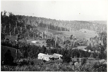
View of the settlement of Harmony Vale taken in 1913 with the guest house Kia Ora, built by George Barber in 1909, in the foreground. This photograph has a detailed inscription on the back handwritten by John Lundy-Clarke.The settlement of Harmony Vale 1913. The large home in foreground is the Guest House “Kia Ora” owned by George Barber on Lot 25 of the Village Settlement. The house above it to the left was Richardson’s house. The home of Jeanie who had left it when the picture was taken.The buildings furthest to the right of “Kia Ora” were the homestead of Isaac Jeeves of 1863 – 1871 the building furthest right with the black opening in it was the house with the tree fern floor. The flat ground above and left of Isaac’s pointed roof barn is where the creek changed its course in the 1934 flood and destroyed £4000 worth of the Rowse family’s tulip bulbs. Above the flat is Francis Matthew Child’s homestead, in the creek to the right of which can be seen the horizontal structure of the swing bridge to the sawmill of the Childs Bros which cannot be seen but in the forest to the right of the mill (bridge) can be seen a number of logs in the mill yard. The two cleared strips immediately behind Childs home were the Richardson’s original holdings and the house in the gully at the far side of the great clearing is that of the guest house “Glenrivers” belonging to W Lucas and his wife Catherine nee Child. The Richardson homestead “Harmony Vale” is behind the forest trees in the right centre. The picture gives a full view of how the settlement was cut into the centre of the great forest. george barber, kia ora, harmony vale, barber, jeanie richardson, richardson, child, matthew child, kia-ora guest house, guest house, glenrivers -
 Kew Historical Society Inc
Postcard, R McGeehan, The Effect of Storm. Train Passing Through Flood Waters, South Yarra, 25-1-07, 1907
SHARP DOWNPOUR. ONE INCH IN 45 MINUTES. SOUTHERN SUBURBS DELUGED. TRAIN STOPPED AT SOUTH YARRA. One of the sudden downpours of rain which occasionally fall in Melbourne occurred yesterday afternoon, when nearly an inch of rain fell in the course of three quarters of an hour, and caused a flood for an hour or two in certain localities. During the early part of the day, the sky had been clouded over, but there was nothing to indicate a storm of such intensity as that which followed. At about half-past 1 o'clock residents of South Yarra, South Melbourne, Prahran, and St. Kilda noticed a few drops of rain. Still, it appeared unlikely that there would be anything exceptional, until with startling suddenness at about 10 minutes to 1 o'clock, one of the heaviest downpours within the memory of residents burst upon those suburbs. A strange feature of the storm was that it was practically confined to an area of about three miles square. The city was but little affected, though at a spot as close as the Observatory 86 points of rain were recorded in three-quarters of an hour. Thunder and lightning accompanied the downpour, which was cyclonic in character, the rain driving heavily from all points of the compass as the cyclone passed. It was in South Yarra and Prahran that the rain fell heaviest. Within a few minutes after it commenced, the low-lying portions of Toorak-road and practically the whole length of Chapel-street were under water. The depression at the intersection of Toorak-road and Darling-street speedily filled to the dimensions of a small lake. Several shops were inundated, while the water from the higher levels rushed down like a mountain torrent, and in several in-stances swept through the rear of houses and shops, carrying furniture in a floating mass against the further walls. In one case a footbridge was carried bodily away and dashed to pieces. Darling-street itself Great Davis-street, and other low-lying and flat thoroughfares in the vicinity became flooded from kerb to kerb, while on the other side of the railway-bridge the valley between Kensington-road and River-street became filled for some minutes to a depth of several feet. Meanwhile the waters from South Yarra hill, seeking a lower level, found it in the railway cutting, and the excavations from South Yarra station to Prahran on the one line, and to the Chapel-street bridge on the other, were converted into a couple of canals. At the platforms at South Yarra the water was two feet deep on the permanent way, and towards Hawksburn, at the sudden depression under Chapel-street bridge, it was at one time deep enough to cover a tall man's head. Into this swirling mass of water the 1:50 p.m. train from Oakleigh plunged on its way to Melbourne. The impact caused a mighty fountain of water to rise to a height of about 20 feet above the level of Chapel-street and send clouds of spray in all directions. Under the belief that a terrible explosion had occurred residents braved the rain and rushed to the spot, only to find that the train had been brought to a stand-still in the middle of what seemed to be a river. The water was so high that it had entered the fire-box from below, extinguishing the fires and cutting off the steam supply. In the meantime the officials at the South Yarra station had been preparing for emergencies. Inspectors were on duty at intervals along the line, and the moment the alarm was given an extra engine was backed carefully down and continued on to connect with the stranded train without losing its own power. There was a delay of about ten minutes in the service for an hour or two, but by 5 o'clock all the trains were running on time again, and the water had run off all but the spot beneath the Chapel-street bridge. Here the water remained about four feet deep until nightfall, and throughout the afternoon several hundreds of people including biograph operators and photographers, were gathered around watching each train pass through. Even with the water two feet lower, this was a work attended with considerable difficulty. Each train had to absolutely force its way through the weight of water, almost enveloped by the spray thrown up, and it was only just able to negotiate the "ford" by using every ounce of steam. ... The Argus, 26 January 1907, p19.The item forms part of the Laurie Bennett collection of thirty-six postcards and photographs of Kew and early Melbourne, donated to the Kew Historical Society in 1980. The postcards in the Bennett collection, like other images in the Society's holdings date from the 1890s to the present and comprehensively indicate points-of-view or scenes considered historically, aesthetically or socially significant in the period in which they were produced.Postcard depicting a flood at South Yarra Station in 1907. The title and photographer's name are identified on the front of the postcard. Donated by L. Bennett, 1980flood - south yarra, trains - melbourne, postcards, r mcgeehan - prahran -
 Bendigo Historical Society Inc.
Book - JOAN O'SHEA COLLECTION: CENTRAL DEBORAH UNDERGOUND PROJECT, 20th June, 1986
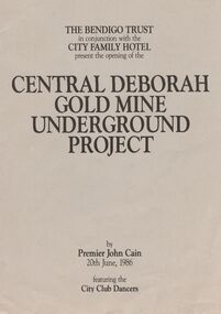
Joan O'Shea Collection. Central Deborah Gold Mine Bendigo Violet Street (off High Street) Bendigo Pamphlet. Buff and Sepia double-sided A4. The Bendigo Trust in conjunction with the City Family Hotel present the opening of the Central Deborah Gold Mine Underground Project, by Premier John Cain, 20th June, 1986 featuring the City Club Dancers. Includes a brief chronological history of the mine and photographs courtesy of Phillip Beer on recto side. The verso side contains a map of the site of the Central Deborah Gold Mine and also various photographs with further detail of areas of interest including: poppet legs and shaft, the change rooms, caretakers or rag pickers room where clothing was searched, the drying room, the first aid room, carbide light room, underground tours, carpenters shed, ore bins and loading bays, stamper battery, wilfley table, berdan plans, laboratory, display room, boiler, stoke hold, winding engine, boiler feed pump, electric driven compressor, steam driven compressor and the blacksmith's shop.Central Deborah Gold Mine Bendigobendigo, gold mining, central deborah gold mine -
 Villa Alba Museum
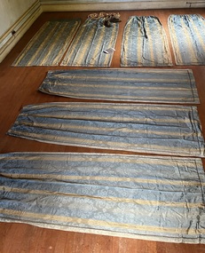
Decorative object - Suite of seven curtain panels, 1850s-90s
The curtains are significant for their comparative rarity of survival, and at the same time, are highly representative of opulent colonial taste in interior decor in the boom period. The curtain panels are of high quality materials and in unusually good condition, indicating they were used in a window with relatively little sunlight shining on them. They can be imagined in a grand room with one or more matching dressed windows.7 curtain panels, all the same size, possibly to fit a 3-light bay window; or alternately, to fit 3 windows in the same room (or something else altogether, if this is not the original total number of panels). Fabric: silk-wool mix, sky blue ground with narrow vertical gold stripes. The fabric is a damask weave with a watered (moiré) finish; the large, woven motif depicts an urn filled with stylised flowers, leaves and curlicues; the spacing of the motifs is more 19thC than older styles using much the same motif. Each curtain drop is decorated with an applied band of narrow, colour-matched gimp braid around the sides and lower end. The bottom hems are weighted with what feels like lead shot. The curtains are lined with sturdy brown cotton. They are gathered at the top edge on drawstring tape; and hand-sewn with small metal hanging rings. Faded vertical bands of sun exposure are visible on most of the curtains, and one panel has a mended tear on a lower side. Otherwise they are in excellent, sound condition.interior decoration-19th century, curtains-19th century, colonial taste-victoria, gold boom melbourne -
 Mission to Seafarers Victoria
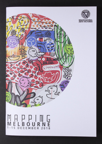
Programme, Multicutural Arts Victoria, Mapping Melbourne 2018, 2018
On 6 December 2018, a recurring event was organised at the Mission. From the Multicultural website: "Meeting at the Seafarer’s bridge on the Yarra, you will be welcomed into a little-known site nearby, a sanctuary for seafarers for the last 100 years and a symbol of old-world generosity amidst the rapidly shifting landscape of the Docklands. A journey through the quirky spaces at Mission to Seafarer’s site through a compelling contemporary ritual performance. The Echoes Projects artists evoke fragments of stories embedded in this site through mesmerising live soundscapes, movement and imagery. Ria Soemardjo, Janette Hoe and Pongjit (Jon) Saphakhun collaborate to create an ongoing exploration of contemporary rituals in response to urban sites in Australia. Based in Melbourne, their contemporary performance work draws deeply from their personal connections to Thai, Chinese and Indonesian ceremonial traditions. Featuring Intricate rhythmic compositions inspired by the rich heritage of Indonesian and Middle Eastern musical traditions, performed by Ron Reeves and Matt Stonehouse – two of Australia’s foremost world music percussionists. Note: 7 PM and 8 PM sessions include delicious vegetarian Indonesian food. 9 PM session includes Indonesian and Thai cakes and sweets. You are invited to stay and eat after the performance, drinks available for purchase at the venue. Performers: Janette Hoe – dance artist Pongjit (Jon) Sekhukhune – actor Ria Soemardjo – musician Ron Reeves – musician Matt Stonehouse – musician /instrument maker Supported by the City of Melbourne Arts Grants Program Details: 6 Dec 2018 (Thursday) Sessions: 7 PM, 8 PM & 9 PM The Mission to Seafarers Audience Meeting point – next to the entrance of the Seafarer’s Bridge, Siddeley St, Docklands. Wheelchair accessible venue. Bookings essential. Tickets: $10 – $15 via Eventbrite. Ticket price is purely to pay for the food element. Companion Card ticketing available. Please contact Multicultural Arts Victoria for ticketing options. Companion ticket will allow admission only. The Seafarers Welcome is presented as part of Mapping Melbourne 2018."The Mission has always welcomed artistic events Colour programme of events with illustrationstop right corner: Multicultural Arts Victoria lower left corner: MAPPING MELBOURNE/1-15 DECEMBER 2018arts, events, multicultural arts victoria, the seafarer welcome, echoes project, 2018, cultural events, community -
 Ballarat Heritage Services
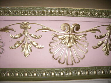
Photograph - Photograph - Colour, Interior, Her Majesty's Theatre, Lydiard Street South, Ballarat, c2015
Her Majesty’s has been a central part of the cultural life of Ballarat since it first opened its doors in 1875. Australia’s best preserved theatre building, it has been continuously used as Ballarat’s home of live performance ever since. It has been owned and operated by the City of Ballarat since 1987 and functions as Ballarat’s premier performing arts centre. The Theatre was first known as the Academy of Music, a name calculated to overcome religious and temperance scruples against patronising a “theatre.” The Academy had a flat floored auditorium suitable for dances and dinners, and a fully equipped stage. It was built to supersede Ballarat’s Theatre Royal (1858), which stood around the corner in Sturt Street, near where the Myer Department store sits today. While very grand, the Royal had become outdated and no longer met the technical requirements of the touring companies. The Academy was built by the wealthy Clarke family at the initiative of a group of local people who felt that Ballarat, as the premier city of the Victorian goldfields, should have a theatre worthy of its status. They guaranteed to rent it from the Clarkes at 10% of the construction cost, which was £13,000. The building of Ballarat’s handsome new theatre was supervised by Clarke’s architect, George “Diamond” Browne. It was ready ahead of schedule, and opened on 7th June 1875. The first production was a comic opera by the French composer Lecocq, “La Fille de Madame Angot,” presented by the Royal Opera Bouffe Company run by W. S. Lyster, Australia’s first opera impresario. Soon after the Academy opened, the large Supper Room above Lydiard Street was leased to William Bridges, a former miner, who ran it as an art gallery, displaying an excellent collection of European and Australian artworks, including his own tapestries. After Bridges moved his operations to Melbourne in 1883, the Ballarat Fine Art Gallery was formed. The Gallery Society ran the Gallery from the Academy from 1884 until 1890, when the present Art Gallery in Lydiard Street North was opened.Colour photograph of interior detail at Her Majesty's Theatre, Ballarat.her majesty's ballarat, theatre, performing arts, her majesty's theatre, academy of music, george browne -
 Bendigo Historical Society Inc.
Administrative record - Spring Gully Gold Mining Co. Fryerstown, Minute Book1903 - 1915, 1924 - 1929
The Spring Gully Gold Mining property consists of Gold Mining Lease No. 2986, Castlemaine, of about 21 acres situated on the Emu Reef, in Spring Gully Fryers. There are two shafts, distant about 300 feet from each other. From one of them large quantities of gold were obtained in former years by previous companies. ( Prospectus of the Spring Gully Mining CompanyMaroon hard cover book, brown leather binding on spine and corners, three hundred and eighty pages. Written on spine of book in gold leaf : 'Minute Book'. Handwritten minute entries from 14th September 1903 to 30th August 1915. Affixed to first page, newspaper clipping from the 'Herald' 13/9/05, with information about the Spring Gully Mine Fryerstown. Page eighty-one has two quotes affixed from 'The Yarraville Chlorination and Ore Reduction Works' High Street Yarraville, July 1905, for works associated with pyrites and blanket sand. Page nine, a handwritten letter affixed to minutes, applying for a block of land 250 feet north of main shaft. Signed by J.S. Potter, H. Hancock, G Murray and T. Tumney. 1.Page one hundred and one: three quotes from 'Edwards' Metallurgical Works' Specimen Hill, Bendigo for pyrites and blanket sand. 2.Page one hundred and fifty five: handwritten letter (copy) from A. Schonfelder re shaft work on the mine and mention of tributors 3. Affixed to inside cover: letter from the 'United Shire of Mount Alexander' April 15th. 1907, regarding the reconstruction of the Vaughan bridge over the Loddon River. 'the benefit that the mines in your district derive from the bridge being open for wood waggons and this being the main traffic and this being the principal cause of the bridges present condition'. 4. Prospectus of the Spring Gully Mining Company, Spring Gull, Fryerstown, two page folded document enclosed inside back cover of book. Prospectus incomplete. (10746.93a) 5. Carbon copy of letter to D.E. Williams Esq, Castlemaine from GlenAthol, Casewick Road, London, January 25th, 1907 regarding two gentlemen who were 'called upon to carry the 'Spring Gullys' through - Mr. H. 'is making a determined effort to bring the matter to a successful issue' Letter signed by George Allan. (10746.93b. 6. Carbon copy of letter from E. Williams, London re proposed new company to acquire the properties of Spring G.M. Coy, Spring Gully G.M. Coy. No. 1, Sth Spring Gully G.M. Coy, Sth Spring Gully G.M. Coy Extended (10746.93c) 7. Handwritten letter to the Chairman and Directors of the Spring Gully G.M. Co. re the appointment of 'Mr. Samuel Morse Battery Manager at once, or accept my resignation as Mining Manager, for we can't agree any longer' Signed by A. Schonfelder. 8. Notice of extraordinary meeting of shareholders in Spring Gully Gold Mining Company No Liability, 22nd November 1906 at Beehive Chambers, Bendigo. Signed W.G. Blackham (Blackham & Garvin) Manager of the Company. (10746.93e) The Minute Book is part of the Margaret Roberts Collection of mining documents.bendigo, margaret roberts, , goldmining, castlemaine, spring gully gold mine, fryertown -
 The Beechworth Burke Museum
Photograph, est. 1860-1875
In 1875, the Rocky Mountain Extended Gold Sluicing Company Ltd was created, utilising the previous Rocky Mountain claim for the area near Lake Sambell. The company employed A.L Martin to survey an area for a tunnel underneath Beechworth and Johnson Stephens to dig it. The tunnel was built at a rate of 40 feet a month and eventually measured 800 metres. The tunnel was a true accomplishment both in the present and during the 19th century. It was considered to be a marvelous engineering feat. Beechworth is renowned for its hydraulic sluice method of mining. This involved soil being exposed to torrents of water from high-pressure hoses. From 1876 until its closure in 1921, the mine produced an astounding 47,926 ozs of gold. Companies like this were the source of income for many Chinese gold-diggers who sought to make their fortune on the goldfields of Beechworth. During the height of the rush, the town had around 7,000 Chinese inhabitants living on the outskirts of town as they were not permitted to live within Beechworth itself.The search for gold is ingrained into the history of Victoria and therefore, images like this one which portrays an open-cut sluicing site can reveal important information for society and technology for the date when the photograph was taken. This image is of important historical significance for its ability to convey information about sluicing and the methods used to find gold in 1910. It also shows a location where sluicing was undertaken which provides insight into the impact of sluicing on the environment at a time when it was done. This image of the Rocky Mountain mine is historically significant as the mining complex is now non-existent, with the only remains being the tunnel built in 1880 by the company, which was considered one of the greatest engineering feats of the time. The image also provides a first-hand look into the social and cultural networks at play during the 19th century with racial segregation of the Chinese at the 'Chinese Camp', as well as an insight into Beechworth's origins during the Gold Rush.A sepia rectangular photograph printed on matte photographic paper as a postcardReverse: Historic Beechworth / 7792.1 / ROCKY MOUNTAIN MINE / Viewed from the “Chinese Camp”, shown partly in the foreground, we see the central plant of the famous Rocky Mountain Mining Company. This extensive complex, of which nothing remains, was situated between Silver Creek and the present Lake Sambell area. The company was responsible for a tunnel cut through solid bedrock underneath the town of Beechworth and surfacing near the keystone bridge on the Wangaratta side. Completed in 1880 it was declared to be one of the greatest engineering feats in Australia. The tunnel is still basically intact today. / Series by Wooragee Graphics: Historic Beechworth. / COPYRIGHT BURKE MUSEUM / No.72 beechworth, rocky mountain mine, sluicing, gold rush, mining, gold -
 Marysville & District Historical Society
Postcard (item) - Colour postcard, Stanley Mullen Pty Ltd, Greetings from Victoria, Early 1900's
A colour postcard with six colour photographs of attractions in an around Marysville in Victoria. This postcard was produced by Stanley Mullen Pty Ltd. of Melbourne as a souvenir of Marysville.A colour postcard with four colour photographs of attractions in an around Marysville in Victoria.Greetings from Victoria The Yea River, Tallangi/ Resting, Fernshaw/ The Rapids, Watts River/ Waterfalls, Sylvia Creek/ Tram Track, Warburton/ Bush Bridge POST CARD Stanley Mullen Pty Ltd., Melbourne Printed in Germany Date Stamp-CARLTON NORTH-VICTORIA/ -2FE10 French stamp Ma soer voudrait favie/ les memes exchanges/ que moi. Son/ addresse est./ Miss. B. Coleman/ 95 Richardson St/ N. Carlton/ Avee mes meilleurs/ souhaits/ Votre tres devouee/ R. Coleman STAMP/ ON/ BACK Monsieur A. Rochet/ 22 Rue Longue,/ Lyon/ Rhone/ Francemarysville, victoria, yea river, tallangi, fernshaw, watts river, waterfall, sylvia creek, warburton, bridge, stanley mullen, postcard, souvenir, tram track -
 Ringwood and District Historical Society
Photograph, Construction of Heathmont railway station by the Wieland family, 1926. Four photographs
3 large black and white photographs (1957-001 to -003) 25x15cms mounted on white board, plus one small B&W photograph (1957-004) 11.2 c 6.7 cms)On 1957-001: Typed below photograph, "Building Heathmont railway station platform by Wieland brother 1926. Note use of plough." On 1957-002: Typed below photograph, "Building Heathmont railway station platform by Wieland brother 1926. Heathmont Rd in Background." On 1957-003: Typed below photograph, "Building Heathmont railway station platform by Wieland brother 1926. Canterbury Rd in Centre Background, Bridge to left." On Reverse of 1957-004, handwritten: "All the men in Heathmont made the Heathmont Station. The one with X over him is dad. This was taken when they were making it before it was burned down, Ruby, xxxxxxxXXX" -
 Warrnambool and District Historical Society Inc.
Model Boat, H. Richter, Cutty Sark, 1964
The Cutty Sark sailing ship was a popular model-making ship. It was a British clipper ship built originally for the China- England tea trade and was one of the last and fastest tea clippers. From 1883 to 1895 it was used to carry wool from Australia to England and held many records for speed during that time. Since 1954 the ship has been on display at Greenwich, England. The model has an etched inscription indicating that it was made by Herman Richter and so it is presumed that he was the maker of this model. A model of the Cutty Sark was made by his father, Edward Richter using wood from the Enterprise wrecked in Lady Bay and that model was in the old Warrnambool Museum. This information was in a newspaper article at the time of Edward Richter’s death. This Herman Richter model may be a copy of his father’s model. The Richters have been prominent in Warrnambool’s history, beginning with Henry Richter who came to Warrambool in the 1850s and worked in the Western Brewery and was licensee of the Royal Archer Hotel. His son Edward who died in 1937 was a prominent Warrnambool resident for 78 years. Herman, the son of Susan and Edward Richter was well-known as a model boat maker and maker of model boats in bottles.This model boat is of great interest because the ‘Cutty Sark’ was a well-known sailing ship and was important in Australia’s maritime history as a carrier to London of Australian wool in the 1880s and 90s. It is also of interest as it was made by a member of the Richter family, a prominent one in Warrnambool’s history with both Edward and his son Herman Richter producing many artefacts connected to Warrnambool’s history – model ships, violin-making, maritime paintings etc. This is the model of a three-masted ship with a hull painted in green and black with gold bands. The ship is mounted on a wooden stand and enclosed in a wooden box with a glass front. The box is varnished and has ornamental patterns in gold and blue on the top and sides. The inside of the box is painted blue and white to represent the sea and the sky.‘Cutty Sark 963Tons by H Richter 1964’richter family, warrnambool, model boat building -
 City of Moorabbin Historical Society (Operating the Box Cottage Museum)
Document, laminated photocopy of 'Plan of Moorabbin 1850', 1853
Weston Bate, 'A history of Brighton' 1962 informs us that in 1840 Henry Dendy, who was a farmer in Sussex England, paid 5,120 pounds sterling @ 1pound per acre for a 'Special Survey of Land in Port Phillip , Australia. Henry arrived in Australia in 1841 on the frigate 'York' with his wife, son, and three servants. He also took advantage of the Government Assistance of Free Immigrants for Survey Purchasers, to help on his estate and persuaded some Sussex men with their families to follow him. However when Dendy arrived in Port Phillip he found that LaTrobe and Gipps were trying to raise the price of land close to Town to 15pounds per acre. Dendy asked merchant J.B.Were to manage his affairs and they went ahead with plans to subdivide the surveyed land called 'The Brighton Estate' This area of land extended easterly from the Port Phillip Bay to East Boundary Road and from North Road to South Road in the Parish of Bourke Victoria. The Privy Council, England , decide that Henry Dendy could purchase the land at 1pound per acre. Land Sales proceeded from 1844 as more immigrants established market gardens, farms and varied businesses in 'Moorabbin'This is a photocopy of a Map of the Moorabbin , County of Bourke c1850 showing the 'Henry Dendy Special Survey 1841'A photocopy of a Map of the Moorabbin , County of Bourke c1850. A3 size laminatedLeft corner : MOORABBIN / COUNTY OF / BOURKEdendy henry, dendy special survey 1841, brighton, moorabbin, ormond, bentleigh, market gardeners, pioneers early settlers, box william, box elizabeth -
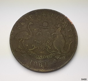 Flagstaff Hill Maritime Museum and Village
Currency - Coin, Robert Hyde & Co. Shipping Merchants, 1861
The donor (a local resident.) of this coin found this penny token coin in the sand dunes of Lady Bay, Warrnambool, in 2023. The coin could have come from a local shipwreck, passengers, or members of the community. Trade was carried out along the southwest coast of Victoria between Melbourne and Portland, with the Port of Warrnambool receiving passengers and goods by coastal traders, the steamboat that set off from ports every few days. One such vessel was the steamship SS Edina that made her first voyage from Melbourne to Portland in 1863. For around a decade or so in the Gold Rush period in Australia there was a shortage of official government currency. It was acceptable during this time to use token coins minted by local businesses to be used within their store, much like the loyalty and rewards cards that businesses give their customers in modern times. The tokens were also a good way to advertise their wares and details. The first token was introduced in Melbourne in 1848 and were used until 1868, when they became illegal in New South Wales. They were minted in Australia and overseas. The token was issued by Robert Hyde & Co. who traded in second-hand goods such as old clothes, sheets, metal items and glass, which they resold to be re-manufactured, or "recycled".A token such as this one identifies businesses existing in the post-Gold Rush period in Australia. Round copper coin. Penny token coin bearing the Australian Coat of Arms and motto. The coin also has the company's name, location, nature of business and motto. The coin has grooves around the edge. It was made in 1861.OBVERSE: Logo: (Australian Coat of Arms), Motto: "PEACE & PLENTY", Date: 1861 REVERSE: "ROBERT HYDE & CO MELBOURNE", "GENERAL MARINE STORE, SHIPPERS OF RAGS GLASS METALS &.C"flagstaff hill maritime museum and village, warrnambool, great ocean road, shipwreck coast, merchant token, melbourne, token, australian token, trade token, coins, merchants, medal, colonisation, gold rush, robert hyde & co., general marine store, shippers of rags glass metals etc., numismatics, second-hand scrap, scrap goods -
 Federation University Historical Collection
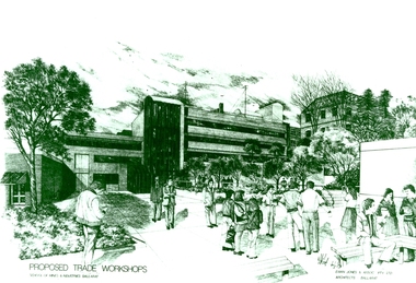
Photograph - Photograph - Black and White, Proposed Ballarat School of Mines Trade Workshops, c1984
A design for a Trade and Art Workshop at the Ballarat School of Mines was prepared by Ewan Jones and Associates on the Albert Street boundary around 1984. The M.B. John Building (Building K), a three storey, face red brick, restrained Late Twentieth Century International styled building with an elongated, cuboid form (defined by the parapeted facades) that is offset by projecting exposed concrete framed, round‐arched entrance and stair wells on the east (Albert Street) elevation (the centrally located entrance breaking the brick façade with glazing). The facades are also characterised by banks of aluminium framed, horizontal ribbon windows, which wrap around the building corners. Metal shades project beyond the windows, while post‐supported bullnosed verandahs and hoods and projecting concrete stairs are other features. On the west elevation, the cuboid façade is punctuated by projecting curved concrete and glazed, elongated bays at first floor level. (David Rowe/Wendy Jacobs) The M.B. John Trade–Art building of SMB was officially opened by the Hon. John Cain, Premier of Victoria, in the presence of Morgan B. John. Programs include 3 Dimensional Art, Painting & Decorating, and Engineering Trades. (SMB Institutional Plan 1989)Black and white photograph of a sketch for the proposed Trade Workshops at the Ballarat School of Mines, from the Albert Street vantage point. This building is known as the M.B. John Building on the SMB Campus.ballarat school of mines, trade workshops, flecknoe, m.b. john, ewan jones and associates pty ltd, albert street, morgan b. john, ewan jones and associates -
 Flagstaff Hill Maritime Museum and Village
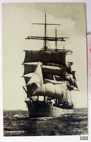
Postcard - Ship, Monkbarns, ca. 1924
This photograph of the Monkbarns was taken prior to 1927 before the sailing ship was converted for use as a hulk. The steel-hulled, 3-masted fully rigged ship was built in 1895 by Archibald McMillan & Son at Dumbarton in Scotland. It was 267 feet long, 40.1 feet wide and 23.5 feet deep. In 1914 John Stewart & Co. owned ten sailing vessels, one of which was the Monkbarns, but by the end of the first World War, the fleet had only four vessels survived the war, including the Monkbarns. The Monkbarns traded across the world. Some of the destinations included Port Adelaide, Table Bay in South Africa, Liverpool, Sydney, London and New York. Her last commercial voyage was in 1926. Overall, the ship traded for 32 years before it was converted in Spain in 1927 for use as a hulk for carrying coal. There were several owners of the ship over its lifetime. They were - 1895, first owner, Charles Webster Corsar, Liverpool - 1902, the owner was D. Corsar & Son, Liverpool - 1909, owned by John Hardie & Sons, Glasgow - 1911, John Stewart & Co., Liverpool - by1915, James A. Young, London - 1926, L.H. Wilson, Liverpool - 1927, Ballener Espando (Brunn & van Lippe, Tonsberg).The postcard shows and example of the sailing ships that traded across the seas and into Australia in the late 19th and early 20th century.Black and white postcard of a sailing ship, fully rigged, at sea. Handwritten on front of card is "Monkbarns"Handwritten on front "MONKBARNS". monkbarns, postcard, sailing ship, flagstaff hill, warrnambool, maritime village, maritime museum, flagstaff hill maritime museum & village, shipwreck coast, great ocean road, newccastle, hulk -
 National Wool Museum
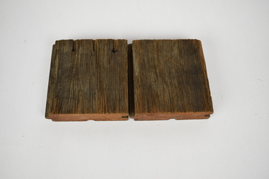
Functional object - Floorboards, 1994
Two short sections of flooring cut for distribution during Deakin Universities ‘Open Day’ in December 1994. This was during the conversion of Dalgety Wool Store to Deakin University’s Woolstore Campus. These small pieces of timber are part of Geelong’s history and were salvaged from the Dalgety Woolstores during the renovations. Hundred of meters of ironbark, red gum, pine and other timbers, some more than a century old, were reclaimed from the site and have been recycled as furniture and featured building materials for the woolstore campus. The old brick stores, located on a formerly neglected section of the Corio Bay shoreline, now house the administration and chancellery, architecture and building schools, information technology services, the student union, a cafeteria and, as the focal facility, a Great Hall seating 1500 people and acoustically tuned for symphony orchestras. The refit was developed from the existing grid of substantial timber columns and beams extending over 52,000 square metres. This framework was filled with lightweight panels to enclose workplaces and removed in some parts to establish courtyards, atriums and streets. The brick facades were redefined with new doors and double-glazed windows in proportion to original fenestration. Bright colours and industrial finishes identify the new insertions.Square sections of redgum lumber cut into floorboards. The sides of the lumber have a grove cut on one side and a matching section to fit within this groove on the other side. This has been done to ensure the floorboards have a tight and consistent fit with one another. The bottom of the lumber also has an additional grove running through the middle of the redgum. On top, one of the sections of lumber has three nail holes, which travel all the way through to the bottom of the wood.deakin university, dalgety wool store, red gum -
 Ballarat Heritage Services
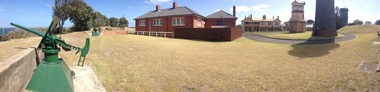
Photograph - Photograph - Colour, Clare Gervasoni, Fort Queenscliff, 2015, 15/03/2015
Fort Queenscliff was established in 1860 when an open battery was constructed on Shortland's Bluff to defend the Port Phillip Bay entrance. The Fort, which underwent major redevelopment in the late 1870s and 1880s, became the headquarters for an extensive chain of forts around Port Phillip Heads. Its garrison included volunteer artillery, engineers, infantry and naval militia, and it was manned as a coastal defence installation continuously from 1883 to 1946. The other fortifications and armaments around the Heads were completed by 1891, and together made Port Phillip one of the most heavily defended harbours in the British Empire. It is claimed that the first British Empire artillery shots of World War One were fired when a gun at Fort Nepean fired across the bow of the German freighter Pfalz, as she was attempting to escape to sea. The orders to fire came from Fort Queenscliff. It is alleged that the same gun, with a different barrel, also fired the first Australian artillery shot of World War II. By 1946 coastal artillery was outmoded, and the Fort became home of Army's Staff College. After the three Service Staff Colleges were combined in Canberra, it became the base for Army's Soldier Career Management Agency in 2001.Colour panoramic photograph of Fort Queenscliffqueenscliff, fort queenscliff, army, volunteer forces -
 Ballarat Heritage Services
Photograph - Photograph - Colour, Fort Queenscliff, 2015, 15/03/2015
Fort Queenscliff was established in 1860 when an open battery was constructed on Shortland's Bluff to defend the Port Phillip Bay entrance. The Fort, which underwent major redevelopment in the late 1870s and 1880s, became the headquarters for an extensive chain of forts around Port Phillip Heads. Its garrison included volunteer artillery, engineers, infantry and naval militia, and it was manned as a coastal defence installation continuously from 1883 to 1946. The other fortifications and armaments around the Heads were completed by 1891, and together made Port Phillip one of the most heavily defended harbours in the British Empire. It is claimed that the first British Empire artillery shots of World War One were fired when a gun at Fort Nepean fired across the bow of the German freighter Pfalz, as she was attempting to escape to sea. The orders to fire came from Fort Queenscliff. It is alleged that the same gun, with a different barrel, also fired the first Australian artillery shot of World War II. By 1946 coastal artillery was outmoded, and the Fort became home of Army's Staff College. After the three Service Staff Colleges were combined in Canberra, it became the base for Army's Soldier Career Management Agency in 2001.Colour panoramic photograph of Fort Queenscliffqueenscliff, fort queenscliff, army, volunteer forces -
 Bayside Gallery - Bayside City Council Art & Heritage Collection
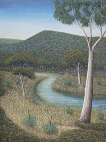
Painting - oil and acrylic on canvas, Robert Kelly, Chinaman's Creek, 2016
Bob Kelly paints landscapes of culturally significant sites along the Mornington Peninsula and depicts these locations as he imagines they originally were before colonisation. Using traditional Western painting techniques, Kelly records the underlying spirit of the Peninsula from a Wathaurong perspective. Chinaman’s Creek in Capel Sound (Rosebud West) was an important watercourse that originally ran from Wonga (Arthur’s Seat) down through Tootgarook Swamp into Port Phillip Bay. It was a great fresh water and food source and home for many Boonwurrung people. Since settlement over 170 years ago, the creek has been drained, blocked, reconstructed and damaged. Kelly depicts a lush green landscape in which the clean creek water winds through the surrounding vegetation of spinifex grasses and gum trees, the background hills are abundant with trees, untouched from man's intervention. Using painstaking detail, Kelly records each blade of grass and ripple on the surface of Chinaman’s Creek. His attention to detail serves to powerfully reimagine this important cultural site, returning it to its former pristine state, and reinvigorating its role as a key place of sustenance for the Indigenous populations of the Peninsula. Chinaman's Creek was a finalist in the 2017 Bayside Acquisitive Art Prize.oil and acrylic on canvaslandscape, creek, trees, chinaman's creek, painting, indigenous, robert kelly, bayside acquisitive art prize, bob kelly, wathaurong, rosebud, arthur's seat, tootgarook swamp, port phillip bay, boonwurrung -
 Wodonga & District Historical Society Inc
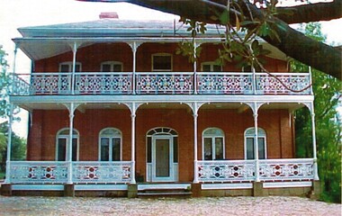
Photograph - de Kerilleau Homestead
The Huon family were early pastoralists in the Wodonga area. They built the mansion, de Kerilleau in 1870 and named after the family's ancestral estate in France. The original lease of the Wodonga Run was granted to Paul Huon as No. 202 on 7th February 1837, about a year after his cousin Charles Huon had squatted on the land. In August 1849, this run was transferred to Paul's son, William. Paul Huon was one of the children of Gabriel Louis Marie Huon de Kerilleau, a French nobleman who fled France during the French Revolution and travelled under a false identity with the Second Fleet in 1794. The mansion, De Kerilleau was built by William Huon in 1870. It is a solid two storey red brick building with cream brick flat window arches. The main feature of the house is its two-storey cast-iron verandah which has been restored to its original condition. When the Governor, Sir George Bowen, his wife and two daughters needed accommodation overnight after having taken part in the celebration of the railway in Wodonga in 1873, they stayed at de Kerilleau. Sir George planted a Moreton Bay fig tree in the grounds and it still stands today. de Kerilleau is a significant building in Wodonga which has been classified by the National Trust.Coloured photographs showing a variety of features of de Kerilleau homestead.huon family, de kerilleau, de kerilleau homestead -
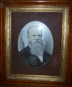 Glenelg Shire Council Cultural Collection
Photograph - Photograph - opalotype, Thomas Must Esq, n.d
Possibly Portland Town Council. Thomas Must, a wealthy Sydney merchant arrived in Portland in 1845. In 1855 prospect was built for Must to a design by local architect George Mathewson. The two storey home was built in expansive grounds with sweeping views of Portland Bay and the township. The stuccoed house is of Regency/Italianate style with a single storey verandah and single storey kitchen wing. In 1878 the original posted verandah was replaced by new verandah and a conservatory to a design of architect Daniel Nicholson. Nicholson had also been responsible for the design of the Assembly Rooms at the London Inn. Thomas Must was active in the Portland Community. He was a Trustee of the Port Philip Savings Bank, a Justice of the Peace, Treasurer of St. Peters Church at Bridgewater and the first Chairman of the Portland Borough Council. Prospect was Thomas Must’s home until his death in 1905. The building has been considerably altered over the years and much of the original Italianate character has been lost. Subsequent owners include B. Cunningham, G.S. Beresford (who changed the property’s name to Waterford), and long-term Liberal Senator Sir Magnus Cormack. Cormack was President of the Senate from 1971 to 1974. In 1976 the Prospect became an aged accommodation centre.Wooden Frame - light brown. Gold inner frame. Fawn mount. Man with long white beard and hair facing right wearing dark jacket. Front: (no inscriptions) Back: (no inscriptions)photography, opalotype, thomas must