Showing 10518 items matching " sections"
-
 Mt Dandenong & District Historical Society Inc.
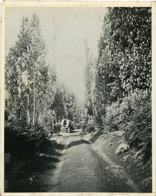
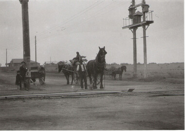
Photograph, Jeeves Coach on CRB Road at Foot of Farringdon Road Kalorama, 1920, 1920
Scene looking down Farringdon Road showing Jeeves horse drawn coach going along the CRB road (Mt Dandenong Tourist Road) in 1920. Detailed inscription on the back handwritten by John Lundy-Clarke in 1974.Jeeves Coach on CRB road at foot of Farringdon Road Kalorama (Mt Dandenong North) 1920. Road was formed most of the length from Montrose by contractors Bladin and Dick employing Robert Logan the younger, in 1919 and lay unmetalled till metalled by the contractors in 1922. Mountain ash trees in foreground were on Thomas Hand’s original 23 acre holding. Those beyond coach were on Isaac Jeeves original 160 acre holding Selection Crown Allotment 925(B). This was the area forming part of the inheritance lost by John William Richardson because of the expense of his wife’s illness. Hand enlarged his 23 acres to 305 in 1874. William and his family grew large crops of raspberries on his area, part of which is in the foreground. It had been cleared by his father’s employees before 1877. The section below the Main Road was cultivated by Fred hand, son of William and grandson of Thomas in the twenties before he moved to Redcliffes where he is today (1974). Comment by John Lundy-Clarke 10.5.1974 coach service, jeeves, crb road, farringdon road, kalorama, mt dandenong north, mt dandenong tourist road, john lundy-clarke, coach -
 Eltham District Historical Society Inc
Document - Report, Paul Jerome, Advisory Committee on a Proposed Convenience Centre and an Alternative Shire Proposal - Eltham Gateway Community Precinct Concept Plan - 895 Main Road Eltham, October 1997
On 15 December 1994 the former Shire of Eltham ceased to exist following the Liberal Kennett Government local council amalgamations. A new Nillumbik Shire Council was established with unelected commissioners appointed. That Council sold the former Eltham Shire Council Offices and land at 89S Main Road Eltham to Dallas Price Homes Pty. Ltd. the sale being conditional upon the granting of a planning permit for a petrol station/convenience store, fast food and video outlet. The sale was conditional that if the permit was not granted by 30 August. 1997, the contract could be avoided by either the purchaser or the vendor. The proposed development consisted of a petrol station with undercover fuelling facilities, convenience shopping, a drive through service facility for fast food, an 80 seat cafe, automated banking, a children's play area and retail space. In addition, the proposal included a 200 square metre community facility for Council use, provision of on site carparking over 2 levels for 83 vehicles, and advertising signage. An Advisory Committee consisting of Dimitry Reed and Margaret Pitt was appointed under Section 151 of the Planning and Environment Act 1987 to hear submissions on the proposal to develop the land at 895 Main Road Eltham, the site of the former Eltham Shire Offices. In September 1996, two applications were made by Contour Consultants Australia Pty Ltd on behalf of Dallas Price Homes Ply Ltd, to Nillumbik Shire Council. After extensive notification, the Council received 213 objections and a petition of over 1400 signatures. On October 9, 1996, Nillumbik Shire Council issued Notices of Decision to Grant Permit on Applications number 96/03376 and 96/0377 for the use and development of the land as a convenience Centre consisting of a petrol station, convenience store, cafe/takeaway food premises, a retail facility and a community facility, with associated advertising signs. Objectors to the proposals lodged Planning Appeals number 96/40724 and 96/40812 with the Administrative Appeals Tribunal on November 1, 1996. The grounds of appeal can be summarised as: inappropriate development, insufficient carparking, traffic and access issues, unsatisfactory design, inadequate permit conditions, the proposal being out of character with the area. and being contrary to the purpose and orderly development of the Eltham Town Centre, excessive noise, lack of consultation and unsuitable signage. On November 13, 1996, the Minister for Planning and Local Government directed the Registrar of the Administrative Appeals Tribunal. under Section 41 (1) (a) of the Planning Act 1980, to refer the Appeals to the Governor in Council for determination without a hearing or recommendation by the Tribunal. The Minister for Planning and Local Government called in the Appeals as he considered that they raised major issues of policy relating to the facilitation of development in accordance with the objectives set out in Section 4 of the Planning and Environment Act 1987, and that determination of the Appeals could have a substantial effect on the achievement of these planning objectives. The Minister required the Advisory Committee to consider the planning merits of the proposed use and development, and to address the issues raised in the objections. The Advisory Committee was required to produce a report providing: • The Committee's response to the matters detailed; • Relevant supporting information for the Advisory Committee's recommendation; and • A description of the proceedings conducted by the Advisory Committee and a list of those consulted or heard by the Committee. In March 1997, elections were held in the Shire of Nillumbik and the view of the new Council to this proposal differed from the view held by the earlier Council Hence the Submission made to the Committee by the Shire was against the decision by the Shire of Nillumbik to issue the Notices of Decision to Grant a Permit. The Recommendations of the Advisory Committee were: i. The cafe and take away food premises are as of right uses and are therefore allowable, but that shop and petrol station are unacceptable uses. A community facility is a discretionary use and is acceptable. ii. A development of the type and scale proposed is totally inappropriate for this land and that the Applications number 96/03376 and 96/0377 for the use and development of the land as a convenience Centre consisting of a petrol station, convenience store, café/takeaway food premises, a retail facility and a community facility, with associated advertising signs, be refused. iii. The land should be rezoned for public purposes and should remain in the community's ownership for community use. Following this, the Minister for Planning and Local Government, the Hon. Robert Maclellan, appointed Mr. Paul Jerome as an Advisory Committee under section 151 of the Planning and Environment Act 1987 to consider a Convenience Centre and an alternative proposal by Iha Shire of Nillumbik being the Eltham Gateway Community Precinct Concept Plan for the site of the former Shire of Eltham municipal offices at 895 Main Road, Eltham. In summary, the terms of reference for the Advisory Committee required it to: • consider the merits of the Council proposal • examine the merits of both proposals in terms of net community benefit • address the report of the previous Advisory Committee on the Convenience Centre proposal The Advisory Committee inspected the site and considered all the material before It including submissions made by all parties to the previous Advisory Committee and correspondence received by the Department of Infrastructure both before and after that Committee submltted its report. The Advisory Committee also held discussions with the following people: • Cr. Robert Marshall • Cr. Margaret Jennings • Cr. Lex de Man • Mr. Dallas Howgate of Dallas Price Properties, also Dallas Price Homes • Mr. Barry Rochford, CEO, Shire of Nillumbik • Ms. Yvonne Rust, Planning Officer, Shire of Nillumbik • Mr. Gregory Burgess, Architect of the Eltham Library and of Council’s Community Precinct Concept Plan • Mr. Jim Connor representing Mrs Thelma Barkway of the Eltham Senior Citizens Club Having considered all the material before it, the Committee arrived at two basic conclusions. First, the DPP proposal should be rejected because, on its merits, It does not sufficiently satisfy the requirements of the planning scheme which is a statutory document. The planning scheme requires that, before making a decision on the permit applications for the DPP proposal, a range of matters must be considered. It follows that consideration of these matters should Influence the decision. These matters include local policies relating to character and amenity. In particular, these policies seek • to conserve and enhance the bushland/country atmosphere, artistic heritage and strong sense of community of the Eltham Town Centre by ensuring that the design and height of any new development is sympathetic to existing buildings • to achieve a pleasing physical environment within the Eltham Town Centre by encouraging a high standard of architecture and urban design • to encourage Improvement to pedestrian amenity through such facilities as open and shattered rest areas and meeting places, crossing facilities, pedestrian arcades, pedestrian links to car parks and pedestrian weather protection • to reduce conflict between vehicular traffic and pedestrian flows, and • to encourage pedestrian thoroughfares It is submitted, as set out In the main body of this report, that the DPP proposal fails substantially to meet these policies and In so doing does not merit the exercise of discretion In Its favour with the Issuing of a permit. This finding is not offset by the investment and employment attributes of the proposal. They do not override the need to comply with the planning scheme. Second, the Council proposal, on Its own merits, substantially meets all statutory requirements applicable to this site with a possible reservation about car parking and traffic management which need further definition and assessment as the concept is refined. The Council proposal, however, has a serious weakness in that Its financial viability has not been adequately tested. The Committee refers to 'financial' rather than 'commercial' viability in recognition that Council owns the land and may enter into a range of agreements and partnerships to realise its concept some of which may be truly commercial and some of which may involve an element of subsidy arising from Council's involvement as a public body acting on behalf of its community. The Committee concludes that Council should be given the opportunity, within a reasonable timeframe to establish the financial feasibility of its concept and should develop a strategy for the future of Its land asset at 895 Main Road in the event that Its concept for the site cannot be realised. 895 main road, advisory committee, dallas price homes, eltham, eltham shire office, nillumbik shire council, planning application, administrative appeals tribunal -
 Bendigo Military Museum
Uniform - UNIFORM, NURSES WW2, 1939 - 1946
The uniform belonged to CAPT GLADYS MOLE VFX17199 AAMC 2nd AIF. Refer 1901.4 for Service History. Items were all numbered 215.01 from a previous institution. See also Reg No 1899 & 1900.2P.WRANC .1) Jacket. Grey, fine wool tailored jacket & skirt. Jacket has full belt fastened with press studs. Front fastened with military buttons, also pocket flaps & 2 buttons on each sleeve. Shoulder epaulettes of dark brown felt with a button 'Australia' badge & 3 captain's pips. Colour patch on each sleeve - brown square on light grey square with central angled blue bar. Service ribbons on right breast. Upper back section & fronts lined with rayon. Hanging tab centre back neck. .2) Shirt. Long sleeved cream cotton shirt with tail, epaulette tabs on shoulders fastened with a button. Front button fastening semi stiff collar. .3) Skirt. Fastens at side with hooks & eyes & 1 button on waist band. .4) Tie. Made of dark brown crepe with silver Rising Sun badge pinned to it. .5) Hat. Grey/green felt velour with band of brown edged both sides with narrow stripes of pale grey & red. Unlined with petersham sweat band & black hat elastic double chin strap. Signs of wear at inner front. .6) & .7) Gloves. Pair, dark brown leather with stitching detail in 3 decorative lines on backs. Previous number 215.01 has been inked inside. .8) & .9) Shoes. Pair, brown leather lace up with stitched soles by Duncan. .2) Self coloured label: V109 MADE IN AUSTRALIA 1942 Inside back neck in ink: G? HOLLOW .5) On label in black: V558 Made in 1943 Australia Size 6-3/4"uniforms, costumes - female uniform, essential services - hospital, nurses -
 Kiewa Valley Historical Society
Book - Ledger Commercial, "Ledger No. 4", Circa 1895
Historically this ledger not only details the legible hand writing of this era but also the day to day commercial activity in this region(first entry in 1895).The neatness and the diligence of those who were required to pen the information was a requirement by all who were in commercial trade. Emphasis on neatness was ingrained in students at a young age. This era was well before general typewriters and computers. Generally all students of commerce required an accuracy in writing and arithmetic. Neatness and order were a selection requirement. This ledger belonged to a general store, which was a forerunner to supermarkets and specialty stores. The shop provided everything from food, postage stamps, nails, tobacco, boots and Epsom salts. The general store provided nearly every product required to exist in a remote rural area of Australia in the 1800's.This item clearly identifies the Kiewa Valley as having a substantial financial hub to accommodate the various commercial enterprises within a rural environment Circa 1880's. Although Kiewa Valley had mining, agriculture, cattle and sheep it was also composed of a mixed society, encompassing all levels of society at that period. It identifies some the commercial activities(newsagency/general store) undertaken by specific families farming in the Kiewa Valley and relates their history in the pioneer period of the late 1800's. Some of those pioneers still have descendants living on the same home sites provided by the 1847 Land Act.This ledger has a very thick cover of strong compressed cardboard. Originally it had a cloth covering both front and back(Glued on) but due to wear and tear it is only attached to the back cover) and is a faded blue colour. The corners of the opening side of the cover are reinforced by suede cloth,in a triangular shape, and enclose both the front and inside portions of the the ledger. The spine is reinforced by a suede section to provide increased strength and protection. The inside cover (both front and back) has an orange bubbles with red and blue sinuous lines forming shapes in a haphazardous pattern. The grammage of the lined sheets (blue) is approximately 120g/m. Originally the first seven of twelve pages were indented and alphabetically marked with black letters (one letter per page) however this ledger had been modified to cover only the initials of customers and the pages of unused letters were glued to the previous page. The remaining pages are numbered in black print at the top outside edge of each page. There are 890 page numbers. Each page has thirty seven blue horizontal lines and one double red line ( top). Each page has thirteen vertical lines starting from the top horizontal double red lines and ending at the bottom of the page. These lines segregate the page into blocks for the date, the transaction and financial input. There are three double vertical red lines which designate the amount of money of each transaction (in pounds, shillings,and pence).On the suede spine in gold lettering and on a red (port coloured) background "LEDGER"grocery shop, haberdashery, general store -
 Warrnambool RSL Sub Branch
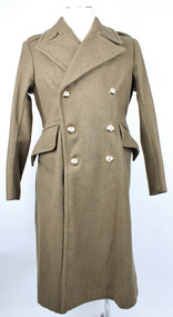
Great Coat, Bradley's Industries N.S.W, 1951
Long khaki coloured heavy coat. Thick, sharp angled collars. Right collar has a hook and eye attached in the lapel split. Collar has zig zag stitching and two plastic buttons on each the left and right sides. Each shoulder has a lapel that is fastened with a plastic button. The coat is double breasted. Three buttons on the right side, held in place by metal loops on the interior rather than stiches; mirrored on the left side. Left interior has oval shaped fabric buttoned to the interior with two brown (possibly bakelite) buttons. A larger brown button sits atop the smaller as a means of closing the jacket from the inside. There are two pockets on the front that are angled with the highest point near the centre and the lowest point near the hips. The arms, underarm and upper back section contains an inside khaki coloured lining of thinner, most likely cotton fabric. Above this there is a thin strip of fabric attached at either short end to use for hanging the coat on a hook. At the back of the coat there is a single pleat stretching from the base of the neck to the base of the coat. Approximately half way down the pleat there is a split in the fabric that is fastened with two plastic buttons. At the waist there are two fabric flaps that fasten together at the back with three buttons, also held in place with metal loops on the reverse.Label on interior back lining reads "REGIMENTAL No./NAME" Label on interior of the right "GREATCOATS. G.S. 1946 Patt/SIZE 1/HEIGHT 5'3"/CHEST 34"-36"/BRADLEY'S INDUSTRIES N.S.W./1951" Handwritten on label, "M J Davis"post war, army uniform, great coat, inter war, uniform, military uniform, wool, greatcoats, bradley's industries -
 Federation University Historical Collection
Book, Machinery for Metalliferous Mines, 1894, 1894
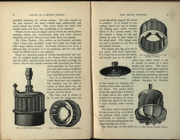
The 1st edition of this famous work, giving an excellent account of the machinery used in late 19th century metal mining in the UK and overseas is very rare. It covers a wide range of equipment - pumps, steam engines, drills, winding engines, stamps & concentration mills, aerial ropeways, tramways and early uses of electricity etc. Brown hard cloth covered book. xvi 564 pages with additional advertisements, with over 300 illustrations and drawings, some fold out. Chapters include Water as a motive power, Wind engines and ventilating machinery, Steam boilers/engines and oil engines, hoisting machinery, draining of Mines, pumping engines, rock drilling machinery, boring machinery, concentration machinery, sizing and classifications trommels, joggers and jigging, fine concentration, milling of gold ores, milling of silver ores, amalgamation plates and machinery, dry and roasting machinery, chlorination and cyandide processes for the extraction of gold, electricity as a motive power for mining, electric lighting and blasting, aerial wire ropeways, transport by rail and road. There a a number of lovely line illustrations in the book including: Poncelot's undershot waterwheel; Fromont furnace;Victor turbine; Pelton waterwheel; Root's positive blower;Cross section and front elevation of Lancashire boiler; Robey's Compound Mill Engine; Portable Winding Plant; Iron Pit Head Gear ; Loading Arrangement in an Incline Shaft; kibble; Worthington Pump; California Pump; Scram's Air Compressor; Rock drill Bits; Special Sharpening tools; Boring tools;Rotating Picking table; Ore Feeder; roller crusher; stamp battery; round buddle; slime table; vanner; amalgamating plant; belt elevator;roasting furnace;splicing wire rope; capel; tipping waggon;mining, cornish pump, linkenbach table, water wheel, ventilation, oil engine, california, america, water, steam boilers, steam engines, oil engines, pumpimg, rock drilling, boring, jiggers, milling, silver, gold, drying and roasting, chlorination, cyaniding, lead, zinc, copper, electricity, electric lighting, wire ropes, transport, wind engine, poppet head -
 City of Moorabbin Historical Society (Operating the Box Cottage Museum)
Photograph - Plateway (Wheelway) Steel, circa 1885
By the later 1800s the dirt roads in the then out-lying areas of the City of Moorabbin became dangerous, and almost impassable due to huge potholes and muddy swampy areas. The heavily laden market gardener’s carts regularly broke axles and wheels, and horses foundered on their way to the Melbourne markets. Even worse, the heavier “iron maidens”, carrying their malodorous loads of sewage from Melbourne’s inner suburbs for dumping in the outlying areas of the City of Moorabbin, also got bogged in the mire. It was decided that a practical solution to this problem was to install a metal plateway on the side of the problematic roads. In about 1887 the Moorabbin Shire Centre Road, in the Brighton East area, two parallel metal rails were installed so that the wheels of carts could run along smoothly, the horse travelled in the filled, middle area between the rails. Point Nepean Road plateway was removed in 1930 and Centre Dandenong Road plateway was removed in 1934-35. The worn plateway along Centre Road, East Brighton (now known as Bentleigh), was gradually taken up in several pieces, commencing in the the1920s, when its condition deteriorated and it caused a hazard to bikes, pedestrians, motor-cycles and the few early cars. The early steel plateway, constructed by David Munro, and opened on 23rd March 1885 by Thomas Bent, was built along Nepean Highway, between Asling St. and Bay St. The Point Nepean Track was subsequently extended into Moorabbin with branches along Centre, Cumins, South, Wickham, and Keys Roads, the total length was 13 miles. In 1908-1909 plates were laid along Centre Dandenong Road to Ross Street Bentleigh This innovative solution proved successful and was used until gradually the main roads were upgraded, and motorised vehicles started to appear. Two parallel metal rails were installed in the right hand side of a few main roads in the Shire of Moorabbin so that the wheels of heavily-loaded market gardener's carts on their way to markets in Melbourne could run along smoothly. The horse pulling the carts travelled in the filled, middle area between the rails. The Steel Plateway was constructed by David Munro, and opened on 23rd March 1885 by Thomas Bent. The wheelway first only ran along Nepean Highway, but it soon extended from Centre Dandenong Road, along Nepean road to its junction with Chapel Street, St Kilda. Later branch lines were built along Centre Road, Bentleigh as far as Warrigal Road and, according to early photographs, along Wickham Road Moorabbin as well. This innovative solution proved successful and was used until gradually the main roads were upgraded, and motorised vehicles started to appear. There was a problem with the wheelway : there was only a single set of rails and this was established on the right-hand side of the Nepean Road, travelling towards the city. Traffic FROM the city travelled on the correct or left-hand side of the road. The exception to this rule was the malodorous iron-clads, heavily riveted iron carts, generally travelling in convoy, carrying several tons of human effluent out of Melbourne to be trenched-in in the sandy soil of the Moorabbin district. Moorabbin City Council donated and installed a small section of Plateway at Box Cottage Museum in 1984melbourne, brighton, moorabbin, roads, plateway, wheelway, transport, st kilda, bent thomas, munro david, market gardens, steelway, carts horse-drawn, iron maidens, point nepean track -
 Bendigo Historical Society Inc.
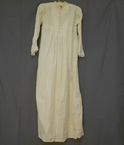
Clothing - AILEEN AND JOHN ELLISON COLLECTION: TROUSSEAU NIGHT GOWN, 1914
Handmade ivory coloured cotton full length night gown. Front has yoke of diagonal pieces of lace with cut work and floral patterns, squares, embroidered flowers with horizontal lace pieces across shoulders. The top edge of the skirt has an edge of lace with square shapes and centre flowers of cut work across the front and back. The back has five 1cm tucks on either side of centre that extend 5cm below the lace edge. The high front neckline is square and the high back neckline is rounded. The neckline is edged with cotton broderie lace and insert lace with cream coloured satin ribbon threaded through. Below the decorative lace strip at the front is a section of fine pintucking 12cm on either side of centre and 9cm below lace strip. The night dress has a front opening extending 31cm from the throat. It has a placket with two button holes 10cm and 20cm from the throat. Two buttons on other side. No fastening at throat. French side seams. Long set-in sleeves with two rows of lace and three rows of pintucks extending from shoulder down top of sleeve to wrist. A piece of insert lace at wrist. A frilled cuff of broderie lace widening from 9cm at inside seam to 12cm at outside edge, machine stitched.costume, female underwear, nightgown -
 Bendigo Historical Society Inc.
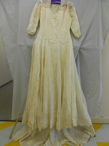
Clothing - HELEN MUSK COLLECTION: CREAM WEDDING DRESS
Full length cream synthetic fabric wedding dress with long sleeves and a train. Front and back have a yoke of lace. Three quarter length sleeves are made of the same lace with roulette trim at hem. Inner and outer edges of sleeves ruched for 3 cm. High round neck at back. V neckline at front. Front of bodice has two side darts and two under bust darts. Bodice at waist line has three decorative scallops at front and back. Synthetic fabric of bodice has woven fabric backing. Side opening on left hand side is fastened with nine press studs. Full length skirt of lighter weight opaque synthetic fabric has centre seams at front and back. Fabric is cut on the bias to form a 360? full circle skirt with a train at centre back. An additional section of fabric is attached at either side to complete the circle. At centre back of the skirt is an inverted pleat to create fullness for the train. Hemline is edged with lace with four rows of tucks above the hem, 1 cm apart. Separate petticoat of heavier woven synthetic fabric attached at waist. Petticoat cut on the bias to create 360? full circle skirt with inverted pleat at centre back to create fullness. Narrow turned over hem. Petticoat skirt dips to a V shape at centre front and back seams. Machine stitched.costume, female ceremonial, wedding dress -
 Bendigo Historical Society Inc.
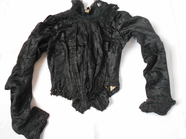
Clothing - GRAYDON COLLECTION: BODICE, 1870-1890
Clothing. Women's black embossed silk bodice. Part of two piece set (skirt 11410.2). Stand up lace collar (7 cm) boned on either side and edged with cream coloured lace. Collar fastened at centre back with three metal hooks and eyes. Front opening left of centre fastened with eight metal hooks and cotton loops and three across the left shoulder. Crossover section at front is pin tucked below the neckline and is tapered into the waist with centre pleats. Both sides of the crossover have decorative beading along the edges. The inner layer of the bodice is fastened at centre front with 15 metal hooks and eyes - alternating directions. The bodice is shaped from the waist with 9 boned casings. The back is shaped in at the waist finishing with two U shaped tails (11cm X 8cm) with V shaped tails (4 cm X 6cm) on either side. The waistline and tails are finished with a double row of decorative black beading. At the waistline at centre back are three metal hooks to attach bodice to skirt. Long sleeves are gathered at the shoulder, shaped at the elbow tapering to the wrist. Below the wrist is a two piece cuff (13cm X 7cm) with decorative black beading. The bodice is fully lined with light brown cotton fabric with grey splash pattern. Historical Notes: This bodice and skirt belonged to Elizabeth Graydon (nee Richardson). Photograph of Elizabeth wearing this outfit (11410.3).costume, female, women's black silk bodice -
Moorabbin Air Museum
Document (item) - Miscellaneous items See list under "Description"
-
 Brighton Historical Society
Clothing - Dress, Day dress, circa 1875-1876
This dress belonged to Ethel Nina Blundell (1876-1949), having been first made for her mother Jane Blundell (nee Burkitt, 1845-1878). Born in Dublin, Jane married James John Blundell Jr at the Black Street Congregational Church in Brighton on 16 March 1874. The Blundells were a socially prominent Brighton family who played an important role in the development of the area. James' father, publisher and bookseller James John Blundell Sr, served as a Brighton Borough Councillor between 1862 and 1867 when the local government was still in its formative years, including holding the position of Mayor in 1864. He was involved in the foundation of the Brighton Volunteer Rifle Corps and was also a strong supporter of the Brighton Ladies Benevolent Society. The Blundell family were active members of the Brighton Congregational Church and supported the construction of the Black Street church, where James Jr served as a deacon for sixty years, in addition to his work in the Crown Land and Survey Department. The dress is believed to have been made for Jane in 1875 or 1876 during her early pregnancy, likely by a local dressmaker. Jane died in 1878 when Ethel was very young, and Ethel was then raised by her father and paternal grandmother. As she never married, Ethel remained living in the family home of 'Eumana', 164 Church Street, and as an adult she assumed the role of hostess whenever she or her father had guests. On these occasions, she reportedly wore her mother's dress. The family home was sold on James Jr’s death in 1924 and Ethel was living at 52 Black Street Brighton when she died in 1949. In the 1930s, Ethel gifted the dress to a close family friend, Dr Jean Kelly. She told Jean that the garment held precious memories, perhaps due to the connection it provided to the mother she had never known. Jean donated the dress to the Merimbula Old School Museum in NSW in 1987, where it was on display for many years. The Museum donated the dress to Brighton Historical Society in 2023.This is a good example of a late nineteenth century day dress, made from two different patterns of russet brown silk brocade and featuring a lobster tail style bustle. The lack of boning combined with waist and hip measurements indicates it may have been made as a maternity dress. It is lined with beige leaf pattern cotton fabric. The princess line fitted bodice of herringbone pattern brocade has a high round neck with small 'mandarin' style collar and buttons down the front to below the waist where it forms an overskirt which is bordered with a band of coffee bean patterned brocade. The overskirt drops down to hem length at the back but from the centre front it is draped up to the back to a point below the waist level. Here it is sewn to the edge of the lobster tail style bustle which is also bordered by the coffee bean fabric. There is a concealed pocket with the opening under the right edge of the bustle. The buttons on the front of the dress have a decorative circlet of small blue flowers around a russet silk covered dome. The long sleeves are set in and slightly full with a contrasting three pleat band of coffee bean fabric with an ornamental turn back from the pleats sewn just above the wrist. The skirt section of the dress is in four 20 cm bands of alternate fabric patterns with the top and third band of coffee bean pattern slightly gathered and the second and fourth bands of herringbone forming pleated ruffles.1870s, ethel nina blundell, jane blundell, jane burkitt, eumana -
 National Wool Museum
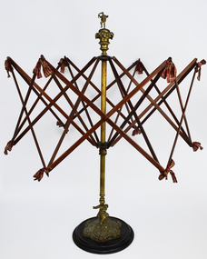
Functional object - Wool Winder, pre. 1950
Originating from Scotland pre-1950, this wool winder is ornately decorated featuring a male figure at its peak and a cherub at its base. Wool Winders are practical objects typically with minimal decoration; however, Wool Winders with ornate design features do exist. Scrimshaw (whale ivory) was a popular choice of material in the 18th and 19th century. It is smooth, preventing yarn from getting caught when unwinding, as well as having artistic beauty. Wool winders require a heavy base, as to not topple over when in use. It is popular to decorate these bases on more elaborate winders, such as shown in this example. The bows featured to tie the wood segments together is another feature of more elaborate models of wool winders, also highlighted in this example. This winder began life in the possession of Annie Crawford. The Crawford name has a strong connection with the town of Paisley, Scotland, and its Woollen Mills. The Crawford name can be seen working at the Woollen Mills in the 1851 Scotland Census, with Robert and his brother’s James and John working as Wool dyers. Their father Alexander also worked as a Loom Weaver. The winder immigrated with Annie when she, her husband and 3 children travelled to Australia, ready to start a new life. Most of their possessions were left behind in Scotland. This winder accompanied the family on their journey; so it stands to reason that the winder was special to them. Annie Crawford passed the winder onto her eldest daughter Joan Crawford. Joan did not have any children and so she passed the winder onto the eldest female grandchild, Fiona Crawford. Fiona Crawford continued the connection of the Crawford name with textiles, with an exhibition titled "When you go looking for me, I am not there". Utilising medieval embroidery tradition of ‘Punto Assisi, the exhibition was a reflection on the lack of women recorded in history, particularly their contribution to the domestic arts. Her work investigates both the absence of women while also honouring the unknown female makers of this now highly desired art. The Wool Winder was donated to the National Wool Museum in 2021 by Dianne Crawford, the sister of Fiona Crawford. Umbrella swift style wool winder made of metal, wood, and ribbon. Decorated at its highest point with a sculpted man standing on one leg, holding what is perhaps a rolled newspaper as though he may be bidding at an auction. Or perhaps he is holding a hank of wool. The man stands upon a three-tier platform of decreasing size and design which leads to the central metal shaft. At the base, the winder is decorated with an engraved cherub. Both figures have a small hole in one of their hands, indicating that they originally held something. Unfortunately, it is not known what this is. From the central metal shaft, this winder has 2 rows of 6 arms radiating out. These arms cross in the middle to form an X. These arms are also connected horizontally with additional arms which cross. This all forms an intricate web design, tied together with ribbon. The size of the web these arms create is adjustable, to accommodate yarns of different length. Beneath the second row of arms is a locking screw which holds this row at the desired height and width. This entire top section, beginning at the central metal shaft, can be unscrewed from its base for easier storage. The base begins in a wooden circular shape growing into a smaller ornately designed raise on which the cherub sits. From the head of the cherub the central metal shaft begins.paisley, scotland, wool winder, immigration -
 Royal District Nursing Service (now known as Bolton Clarke)
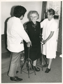
Photograph - Photograph, black and white, Barry Sutton, 24.04.1974
This photograph is taken in the lady's home, and the Medical Student and Royal District Nursing Service (RDNS) Sister are supervising the lady walking with two 4 prong sticks.From the founding of the Melbourne District Nursing Society (MDNS) in 1885, known as Royal District Nursing Service (RDNS) from 1966, the rehabilitation of patients to ensure they were able to live independently in their own homes was at the forefront of care given by their Trained Nurses (Sisters). As well as teaching and supervising the use of equipment, their Sisters taught them safe transfer techniques. These techniques were also taught to family members to enable them to care for their loved ones. RDNS at first held workshops given by a contracted private Physiotherapist before employing their own Physiotherapist in 1975 who taught staff the correct techniques, not only for safety of the patient, but to reduce physical strain on RDNS nursing staff and patient’s family members. When required the Physiotherapist accompanied the Sister on her visit to the patient in their home.On the left of this black and white photograph is the rear view of a Medical Student who is standing side-on looking towards the right, and smiling at an elderly lady. He has short dark curly hair and is wearing a white hospital style coat, which has a stethoscope folded in the pocket, over grey trousers. His right hand is resting on top of the lady's right hand which is on the top of a metal 4 prong stick. The lady, who is wearing glasses and has short wavy grey hair, is standing holding the tops of the metal 4 prong sticks which are standing either side of her on the grey carpet. She is smiling at the doctor. She is wearing a black skirt and a black sleeveless jacket over a black and white patterned blouse, and is wearing black shoes with her left shoe raised with a deep sole and heel. To her right, standing side-on facing her, is a Royal District Nursing Service (RDNS) Sister who has her long dark hair drawn back. She is wearing a white short sleeve gown and her right hand is behind the lady; her left hand is on the lady's right hand on top of the 4 prong stick. In the left background is a vinyl style grey couch and on the right is a window with open Venetian blinds and open long dark curtains on either side. An air-conditioner sits in the lower section of the window.Barry Sutton Quote 25royal district nursing service, rdns, rdns rehabilitation -
 Royal District Nursing Service (now known as Bolton Clarke)
Photograph - Photograph, black and white, c.1956
This photograph is taken in the bedroom of the man's home in the suburbs of Melbourne. It depicts one of the types of nursing care given by Melbourne District Nursing Society (MDNS) Sisters in the community. The Sister is visiting the man's home and is administering an injection which has been ordered by a doctor. Glass syringes were used by the Society until the mid 1960s and were re sterilized for future use. After this time plastic disposable syringes were used.The Trained nurses of the Melbourne District Nursing Society (MDNS), later known as Royal District Nursing Service (RDNS), visited patients in their home and gave best practice care in many fields of nursing and to people of many cultures throughout its 130 years of expansion. Initial visits not only assessed the specific nursing situation but the situation as a whole. Their patients ranged in age from babes, children, adults to the elderly and referrals were taken from Hospitals, General Practitioners and allied Health facilities. Some of the care provided was: – Post-Natal care given to mother and babe, Wound Care following various types of surgery, accidents, burns, cancer, leg ulcers etc. Supervising and teaching Diabetic Care, including teaching and supervising people with Diabetes to administer their own Insulin, and administering Insulin to those unable to give their own injections. Administering other injections and setting up weekly medication boxes. The Sisters performed Catheterizations on adults suffering from conditions such as Quadriplegia, Paraplegia, Multiple Sclerosis (MS), Motor Neurone Disease (MND) and Guillan-Barre Syndrome, and when required at school on children for e.g. those with Spina Bifida. The Sisters visited those requiring Cystic Fibrosis support and care; those requiring Haemo-Oncology care, including visiting children at school; those requiring Home Enteral Feeding care, and those requiring IV therapy at home and home Dialysis. Palliative Care was given including pain relief with the use of syringe drivers, personal care as needed, and advice and support to both patient and family. RDNS provided Stoma management to those needing Urostomy, Ileostomy and Colostomy care and those requiring Continence care. HIV/AIDS nursing care was provided; visits to Homeless Persons were made. Personal care was given to patients ranging in age and with varying mobility problems, such as those with MS, MND, Guillan-Barre Syndrome, Quadriplegia, Paraplegia, Acquired Brain Injury, following a Cerebrovascular Accident (Stroke), those with severe Arthritis and those with a form of Dementia. When necessary the elderly were assisted with personal care and advice given on safety factors with the use of hand rails, bath or shower seats, and hand showers. Rehabilitation with an aim towards independence remained at the forefront of the Sister’s minds and when possible using aids and instruction on safe techniques enabled the person to become fully independent. All care included giving advice and support to the patient and their Carers. The Sisters liaised with the persons Doctor, Hospital and allied Health personal when necessary.On the left of this black and white photograph, is a Melbourne District Nursing Society Sister who is standing side-on and leaning slightly forward as she administers an injection into the right upper arm of a gentleman to her right who is sitting up in bed resting against two white covered pillows. The male patient has short dark hair; is wearing glasses, and is looking up at the Sister. He is wearing a thick grey cardigan over a pale colour pyjama top which has dark piping; the lower part of his body is covered by a dark and light coloured check bed cover. The bed has a solid wooden headrest with a bed lamp attached to its upper right. The Sister who is wearing her uniform grey brimmed hat over her dark short hair, is wearing a white gown over her grey uniform, the collar of which is seen. Three fingers of her left hand are holding back the pushed up sleeve of the man's cardigan and she is holding a white swab between her thumb and first finger. She has a glass syringe resting in her right hand with her thumb and forefinger resting against the lower glass and metal section of the syringe; part of the metal needle is seen, the rest is inserted in the mans upper arm. On the far left of the photograph part of a dressing table mirror can be seen.' Rough Proof' Latrobe Studios Ref No. 59134-8melbourne district nursing service, mdns, royal district nursing service, rdns, rdns - injection -
 Ballarat Tramway Museum
Slide - 35mm slide/s, Noel Simons, 21/11/1962 12:00:00 AM
Set of 6 transparencies taken on 21/11/1962 on Kodak mounts. 1189.1 - Bendigo No.11 at Quarry Hill terminus. Photo taken looking in along the route. Tram has destination of North Bendigo. 1189.2 - No. 21 in Pall Mall bound for North Bendigo. Tram has roof ads for Mamouney's furniture and SEC. In the background are the National Bank building, Dad and Dave's Cafe and the Beehive Buildings and the London Pharmacy. 1189.3 - No. 2 in Mitchell St, just after crossing over railway bridge. Photo taken after tram has passed photographer. Has what appears to be an SEC road works crew in the background. Has destination of Quarry Hill. 1189.4 - No. 17 climbing Mitchell St. on the start of the single track section, just before crossing the railway bridge. Has destination of Quarry Hill and the large Maples building sign in the background. 1189.5 - as for 1189.4 but after tram has passed photographer. Has an Ilford film roof ad and an SEC roof ad. Railway bridge in the background. 1189.6 - No. 21 at Charing Cross with passengers boarding. Tram has destination of North Bendigo and roof ads for SEC 'Electric Cooking' and Sandhurst Milk. In background are the buildings on the south side of High St. Also has a SEC worker in white overalls sweeping the track.Information written on in black ink and date stamped on purple ink. 1189.1 - "Birney car No. 11 in High St. Bendigo at Golden Square terminus" 1189.2 - "No. 21 in Pall Mall Bendigo near Charing Cross" 1189.3 - "No. 2 in Mitchell St. Bendigo, just after crossing bridge over railway line (Quarry Hill route)" 1189.4 - "No. 17 in Mitchell St. Bendigo, climbing the hill the bridge over the railway line. (Quarry Hill route)" 1189.5 - "No. 17 in Mitchell St., Bendigo approaching bridge over Railway line (Quarry Hill route)" 1189.6 - "No. 21 at Charing Cross, Bendigo"tramways, trams, bendigo, golden square, pall mall, mitchell st., quarry hill, tram 2, tram 11, tram 17, tram 21 -
 Ballarat Tramway Museum
Photograph - Black & White Photograph/s, Nov. 1965
Set of seven Black and white photographs on Kodak paper for the arrangements and work for the track reconstruction of Commercial Road Prahran. Series of photos show Down track already complete. Probably second half of October or early November 1965. (Electric Traction 11/65) (Unusual to have two jobs at once - see Hawthorn Rd - Reg item 1421). Series show the construction method. Temporary track formed by progressively lifting original track on to side of road each night. Relaying then follows progressively. Pictures show almost completed section (1423.1 &2), concreting (1423.3), new rails in situ (1423.4&5),newly moved track (1423.6&7), excavation taking place (1423.7) 1421.1 - Commercial Rd looking west at Charles St showing ramp to temporary city bound track. 1423.2 Ditto - just west of Charles St. 1423.3 Ditto - corner Perth St on left, Hyland St on right. 1423.4 Ditto - between Perth and Donald Sts. Scrubber car No 9. 1423.5 Ditto - looking east between Perth and Donald Sts. - W5 723 on new track, W5 722 on temporary track. 1423.6 Ditto - looking east. Max Hotel on corner of Donald St. 1423.7 Ditto - looking east at corner of Alfred St. Scrubber car No 9. See P.Winspur note with item 1418.trams, tramways, commercial road, reconstruction, trackwork, mmtb, tram 9, tram 723, tram 722 -
 Ballarat Tramway Museum
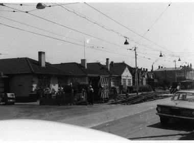
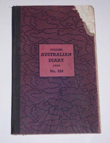
Administrative record - Log book, Diary, Collins Bros, 1959
Yields information about the track maintenance activities of the track gang in Ballarat, the work they did, notes, names and other information.Collins Australian Diary, 1960, No. 324 printed by Collins Bros, pattered dark red cover with green cloth binding on cover, card covers, sewn sections with ruled sheets providing a diary for 1960, one week per double page. Has "useful information" sheets at from the diary. Used by the SEC Ballarat track gang to record their daily work, leave, welding, track cleaning, truck driver etc Rear pages - has notes on materials used, costs, scrubber use and hours, and length of track On the2nd last page is a list of Track gang and addresses for 1960. H. Dowie S. Eaton W. Newell E. Lakey J. Armstrong J. Naus - welder C. Edwards A. W. Cunningham H. Lancaster H. Smith G. McQuinn E. Fish W. Holder L. Marks D. Wiseman - welder Cash account sheets for April - September - weekly hours of workers. Loose contents 1. - by rates of postage sheet - notes on work on rear of time sheets 2 - by rain chart - application for leave form 3 - by engagements - for July - part of a 1960 income tax return form - with some calculations on it. 4 - 19/12/1960 - notes re work 5 - Memoranda sheet - notes on pink time sheet - re work requirements? 6 - Inside rear cover - a sheet with names and SEC leave due notes. tram, trams, sec, ballarat, depot, trackwork, rails, scrubber tram -
 Ballarat Tramway Museum
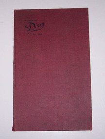
Administrative record - Log book, Diary, Collins Bros, 1966
Yields information about the track maintenance activities of the track gang in Ballarat, the work they did, notes, names and other information.Collins Australian Diary, No. 324 printed by Collins Bros, dark red card covers, sewn sections with ruled sheets providing a diary for 1967, one week per double page. Has "useful information" sheets at from the diary. Used by the SEC Ballarat track gang to record their daily work, leave, welding, track cleaning, truck driver etc Loose contents 18/6/1967 - SEC Sub-Requisition - weld two VR rail joints, Doveton St level crossing 9am Sunday 25/6 2nd last page - note re leave entitlements and work over the Christmas period. Mark Clough Wiseman Weightman Smith Palmer Rose Blake Inside back cover 1. - Sub-requisition for tree cutting 2. - Memo dated 18/8/1966 re electrolysis and welding and testing of joints to Reg Item 3707.. 3. - memo dated 29/11/1967 re tree clearing in Bungaree 4 - Sub-requisition re truck use re tree clearing 5 - Weekly time sheet for R. Palmer - Track cleaner, dated 29/12/1967. 6 - Four requisitions for undertaking non tramway work 7 - List of invitees to a SEC safety coittee meeting - on rear a list of names and leave owing. tram, trams, sec, ballarat, depot, trackwork, rails, scrubber tram -
 Ballarat Tramway Museum
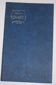
Administrative record - Log book, Diary, Collins Bros, 1970
Yields information about the track maintenance activities of the track gang in Ballarat, the work they did, notes, names and other information.Collins Australian Diary, No. 324 printed by Collins Bros, dark blue card covers, sewn sections with ruled sheets providing a diary for 1971, one week per double page. Has "useful information" sheets at from the diary. Used by the SEC Ballarat track gang to record their daily work, leave, welding, track cleaning, truck driver etc. Names of gang often mentioned in the diary undertaking specific jobs and when on leave. Last day work recorded - 24/9/1072. Loose contents Inside front cover Workshop requisition to fill pot holes and note re rail requirements for Daylesford and Hamilton. Clip to page with metal paper clip. 29/8/1971 - note re account numbers and on rear of a pink requisition form - work list for gang. 12/9/1971 - Workshop Requisition form - green dated 6/5/1971 Inside rear cover Circular for a Male Cleaner in Traralgon Workshop Requisition for work at the Zone substation - Ballarat South Circular to authorised drivers re used of defective vehicles. Has W. Vermeend name typed in top left hand corner. SEC Long Service Regulations circular - has name D.Wiseman handwritten in top right hand corner. 5 sheets of blue carbon paper.tram, trams, sec, ballarat, depot, trackwork -
 Ballarat Tramway Museum
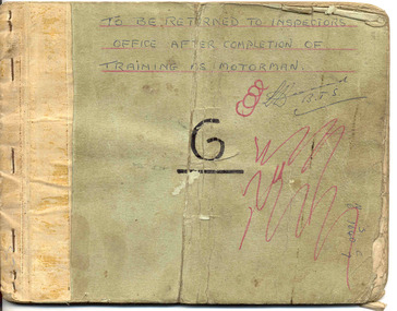
Book, State Electricity Commission of Victoria (SECV), Ballarat Motorman (Driver) Training Manual or Guide - not a formal title, 1960's?, 1950's?
Demonstrates aspects of the Ballarat Tramways system of training Motorman or drivers in the 1960's and the information there were given on driving trams. Shows the training methods of the time. 3486.1 - also details "Dead Man Brakes"Thirty Three page - carbon copy - within stapled light card covers - Ballarat Motorman (Driver) Training Manual or Guide - not a formal title. On front cover is large letter "G" and words "To be returned to the inspectors office after completion of Training as Motorman" First four pages has index and covers: (A) Tramcar Equipment - electrical - items or clauses 1 to 28 (B) Location of Faults - items 29 - 41 (C) Tramcar Braking - items 42 to 59 (D) Failure of the Mechanical Brakes - items 60 to 67 (E) Tramcar Emergency Braking (Accident Prevention) - items 68 - 72 (F) Automatic Electric Signals - items 73 - 82 - gives locations of signals. (G) General Instructions - items 83 to 98. See condition notes - not in the best condition - needs careful handling. 3486.4 - ditto - similar to above, but 34 pages through to instruction 104. Added section (F) after (E) - "Automatic Braking - clauses 72 - 79, possibly an earlier version of above when trams were fitted with dead man controls. Held within a cardboard folder with a metal binder. Cover has been covered with brown paper and adhesive tape, but only remains on the inside of the cover. Item added 3/10/2007. See Reg Item 8110i for a Bendigo, c1940 version.See above 3486.1 - has "Hall G - M.Cond" on front cover. Another name has been rubbed out.trams, tramways, driver training, sec, signals, braking, equipment, emergency, dead man controls -
 Bendigo Historical Society Inc.
Photograph - HILDA HILL COLLECTION: BLACK AND WHITE PHOTOS, 1917-1923
Series of Black & White Photos Total of 10 two severely damaged detailing the life of the Hill family and friends during the war and post World War One.Frank and Dev photo severely damaged. Vin astride an old Indian motorcycle Reg no. 24797, street setting showing gutter dilapidated paling fence further background shows large building with spire. Mollie and Hilda wooden framework of a gateway, severely damaged. Darkie the horse in forested situation 'The Pines' January 1919. Doreen sitting on the backrest of a long seat wearing a dark coloured dress with white collar trees and shrubbery in background. Dora wearing a dark dress with white collar standing in a garden situation , lawn and hedge in background, 'The lawns' 1917. Royston standing in school uniform of dark suit white shirt and dark tie, two younger boys (unnamed) kneeling on the ground both wearing grey suits white shirts and dark ties, all amid long grass, white picket fence and hedge with trees in the background. 'Jock' small terrier or foxy standing on a white chair in front of a palm tree, distant background shows sections of a picket fence. Miss Tovey dressed in white next to a brick wall, to her left fence with hedge at 'The Ranche' 1918.Hal attired in warm dark clothing and wearing a white beanie at Mt Buffalo July 1923.Hilda Hill Personal Collectionaustralia, history, post war life -
 Bendigo Historical Society Inc.
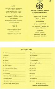
Document - PETER ELLIS COLLECTION: BENDIGO CLUB FIRST ANNUAL OLD TIME BALL, 1st June, 1984
Yellow folded card. P.Ellis and 2 in circle hand written at top on front. Circular Emblem. Bendigo Club First Annual Old Time Cabaret Ball Friday, June 1st, 1984 8.30 p.m. - 1.30 a.m. $8.00 per head Band: Armstrongs. Star of Evening Belle of Ball Matron of evening. Sections: Geelong Red Sash Warnambool Blue Sash Warnambool Green Sash. Inside reads: Programme 1 Foxtrot 2 Valeta 3 Maxina 4 Foxtrot 5 Charmaine 6 Waltz Oxford 7 Progressive Barn Dance 8 Foxtrot 9 Tangoette 10 Pride of Erin (Star Dance) 11 Parma Waltz 12 Modern Waltz 13 Quick Step (Monte Carlo) 14 Lucile 15 St. Bernard 16 Foxtrot 17 Swing Waltz 18 Evening Three Step 19 Foxtrot 20 Merrilyn 21 Dorothea 22 Foxtrot 23 Irene 24 Hawaiian 25 Foxtrot Thanks for coming hope you enjoyed the evening. Rear reads: Supper Party Pies, Pasties, Sandwiches, Chicken Salad Platters, Cream Sponge, Small cakes, Pavlova, Fruit Salad, Coffee. Catering by Eric Brookes Catering Service who caters for Weddings and Special Occasions Dinner A La Carte 028 Community Service Groups (Rotary, Lions etc) Telephone (054) 43 1359person, individual, peter ellis oam -
 Bendigo Historical Society Inc.
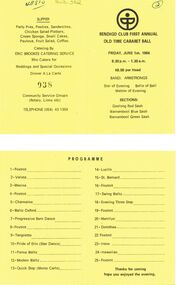
Document - PETER ELLIS COLLECTION: BENDIGO CLUB FIRST ANNUAL OLD TIME BALL, 1st June, 1984
Yellow card Black stick figure drawing in circle. 2 in circle handwritten in top right hand corner. Bendigo Club First Annual Old Time Cabaret Ball Friday, June 1st, 1984 8.30 p.m. - 1.30 a.m. $8.00 per Head Band Armstrongs Star of Evening Belle of Ball Matron of Evening Sections: Geelong Red Sash Warnambool Blue Sash Warnambool Green Sash. Programme 1 Foxtrot 2 Valeta 3 Maxina 4 Foxtrot 5 Charmaine 6 Waltz Oxford 7 Progressive Barn Dance 8 Foxtrot 9 Tangoette 10 Pride of Erin (Star Dance) 11 Parma Waltz 12 Modern Waltz 13 Quick Step (Monte Carlo) 14 Lucile 15 St. Bernard 16 Foxtrot 17 Swing Waltz 18 Evening Three Step 19 Foxtrot 20 Merrilyn 21 Dorothea 22 Foxtrot 23 Irene 24 Hawaiian 25 Foxtrot Thanks for coming hope you enjoyed the evening. Supper Party Pies, Pasties, Sandwiches, Chicken Salad Platters, Cream Sponge, Small Cakes, Pavlova, Fruit Salad, Coffee. Catering By Eric Brookes Catering Service Who Caters for Weddings and Special Occasions Dinner A La Carte 038 Community Service Groups (Rotary, Lions etc) Telephone (054) 43 1359. 411510 handwritten on back.person, individual, peter ellis oam -
 Kew Historical Society Inc
Plan, Melbourne & Metropolitan Board of Works : Borough of Kew : Detail Plan No.1576, 1904
The Melbourne and Metropolitan Board of Works (MMBW) plans were produced from the 1890s to the 1950s. They were crucial to the design and development of Melbourne's sewerage and drainage system. The plans, at a scale of 40 feet to 1 inch (1:480), provide a detailed historical record of Melbourne streetscapes and environmental features. Each plan covers one or two street blocks (roughly six streets), showing details of buildings, including garden layouts and ownership boundaries, and features such as laneways, drains, bridges, parks, municipal boundaries and other prominent landmarks as they existed at the time each plan was produced. (Source: State Library of Victoria)This plan forms part of a large group of MMBW plans and maps that was donated to the Society by the Mr Poulter, City Engineer of the City of Kew in 1989. Within this collection, thirty-five hand-coloured plans, backed with linen, are of statewide significance as they include annotations that provide details of construction materials used in buildings in the first decade of the 20th century as well as additional information about land ownership and usage. The copies in the Public Record Office Victoria and the State Library of Victoria are monochrome versions which do not denote building materials so that the maps in this collection are invaluable and unique tools for researchers and heritage consultants. A number of the plans are not held in the collection of the State Library of Victoria so they have the additional attribute of rarity.Original survey plan, issued by the MMBW to a contractor with responsibility for constructing sewers in the area identified on the plan within the Borough of Kew. The plan was at some stage hand-coloured, possibly by the contractor, but more likely by officers working in the Engineering Department of the Borough and later Town, then City of Kew. The hand-coloured sections of buildings on the plan were used to denote masonry or brick constructions (pink), weatherboard constructions (yellow), and public buildings (grey). Development in the 20th century has irreparably altered that part of Kew represented in this plan. In the block bounded by Cotham Road, Charles Street, Wellington Street and Gellibrand; just one house standing in 1903 remains. This block included two of the most historic houses in Kew: ‘Ordsall’ (later ‘Southesk’) and ‘Madford’ (previously ‘Elm Lodge’). Ordsall was the home of the second chairman of Kew, John Halfey. It contained some of the most significant interior murals in Kew, created for Halfey by artists working for Cullen & Co. It was demolished in 1960 to make way for the Kew Civic Centre. Elm Lodge had been built for William Siddeley in ca. 1864. Arthur Septimus King purchased it in 1874. The lower paddocks of Madford were sold in 1905 by his wife to the Borough of Kew and, after landscaping by George and Thomas Pockett, opened as the Alexandra Gardens in 1908. Elm Lodge/Madford was in 1922 to become St. Anthony’s Home for Little Children before its subsequent demolition in the 1980s.melbourne and metropolitan board of works, detail plans, maps - borough of kew, mmbw 1576, cartography -
 Kew Historical Society Inc
Plan, Melbourne & Metropolitan Board of Works : Borough of Kew : Detail Plan No.1581, 1904
The Melbourne and Metropolitan Board of Works (MMBW) plans were produced from the 1890s to the 1950s. They were crucial to the design and development of Melbourne's sewerage and drainage system. The plans, at a scale of 40 feet to 1 inch (1:480), provide a detailed historical record of Melbourne streetscapes and environmental features. Each plan covers one or two street blocks (roughly six streets), showing details of buildings, including garden layouts and ownership boundaries, and features such as laneways, drains, bridges, parks, municipal boundaries and other prominent landmarks as they existed at the time each plan was produced. (Source: State Library of Victoria)This plan forms part of a large group of MMBW plans and maps that was donated to the Society by the Mr Poulter, City Engineer of the City of Kew in 1989. Within this collection, thirty-five hand-coloured plans, backed with linen, are of statewide significance as they include annotations that provide details of construction materials used in buildings in the first decade of the 20th century as well as additional information about land ownership and usage. The copies in the Public Record Office Victoria and the State Library of Victoria are monochrome versions which do not denote building materials so that the maps in this collection are invaluable and unique tools for researchers and heritage consultants. A number of the plans are not held in the collection of the State Library of Victoria so they have the additional attribute of rarity.Original survey plan, issued by the MMBW to a contractor with responsibility for constructing sewers in the area identified on the plan within the Borough of Kew. The plan was at some stage hand-coloured, possibly by the contractor, but more likely by officers working in the Engineering Department of the Borough and later Town, then City of Kew. The hand-coloured sections of buildings on the plan were used to denote masonry or brick constructions (pink), weatherboard constructions (yellow), and public buildings (grey). The streets and built structures in this plan were surveyed in 1903 and released to contractors in 1904. In addition to the designation of building types by colour, the plan includes detailed descriptions of land use and ownership. While many buildings remain from this period, a number of the buildings represented have been demolished including the original Kew Town Hall, and the Congregational and Roman Catholic churches in Walpole Street. While the mansion ‘Illapa’ in Princess Street is still extant – now part of ‘Rylands’ – the neighbouring mansion ‘Elsmere’ was demolished some decades ago. Rivalling Illapa and Elsmere in size were two mansions in Walpole Street, one named on the plan as ‘Gnarlbine’. Over time, Kew Junction and the south side of High Street have been reconfigured and widened, so that the commercial buildings on the corner of Princess and High Street no longer exist. A surprising feature of this part of central Kew to the northwest of Kew Junction is the amount of vacant land. In a number of cases, this land is noted by the contractor as used for vegetable gardens.melbourne and metropolitan board of works, detail plans, maps - borough of kew, mmbw 1581, cartography -
 Kew Historical Society Inc
Plan, Melbourne & Metropolitan Board of Works : Borough of Kew : Detail Plan No.1297, 1904
The Melbourne and Metropolitan Board of Works (MMBW) plans were produced from the 1890s to the 1950s. They were crucial to the design and development of Melbourne's sewerage and drainage system. The plans, at a scale of 40 feet to 1 inch (1:480), provide a detailed historical record of Melbourne streetscapes and environmental features. Each plan covers one or two street blocks (roughly six streets), showing details of buildings, including garden layouts and ownership boundaries, and features such as laneways, drains, bridges, parks, municipal boundaries and other prominent landmarks as they existed at the time each plan was produced. (Source: State Library of Victoria)This plan forms part of a large group of MMBW plans and maps that was donated to the Society by the Mr Poulter, City Engineer of the City of Kew in 1989. Within this collection, thirty-five hand-coloured plans, backed with linen, are of statewide significance as they include annotations that provide details of construction materials used in buildings in the first decade of the 20th century as well as additional information about land ownership and usage. The copies in the Public Record Office Victoria and the State Library of Victoria are monochrome versions which do not denote building materials so that the maps in this collection are invaluable and unique tools for researchers and heritage consultants. A number of the plans are not held in the collection of the State Library of Victoria so they have the additional attribute of rarity.Original survey plan, issued by the MMBW to a sewage contractor with responsibility for constructing sewers in the area identified on the plan within the Borough of Kew. The plan was at some stage hand-coloured, possibly by the contractor, but more likely by officers working in the Engineering Department of the Borough and later Town, then City of Kew. The hand-coloured sections of buildings on the plan were used to denote masonry or brick constructions (pink), weatherboard constructions (yellow), and public buildings (grey). This plan of Kew encompasses the area bounded by Barkers Road, High Street and Stevenson Street. Because of the angle created by High Street, a number of houses on the northern side of High Street are shown. The area is dominated by one of the great original landholdings in Kew, described here as the ‘Findon Paddock’. ‘Findon’, the house from which the name of the paddock was taken fronts Stevenson Street and was clearly a rambling structure. The best-known occupant of Findon was Henry ‘Money Miller’ who bought the house in 1871. Miller was a member of Victoria’s first parliament and assisted in the framing of its constitution. Findon was to be subdivided as early as 1912, when the Findon Subdivision was advertised to be sold by auction. In the plan of the subdivision, the original house is not shown, so, presumably it had previously been demolished. Fincham & Son moved the organ, built by Henry Willis, which was installed in the house, first to ‘Whernside’ in Toorak, and later to the Box Hill Methodist Church.melbourne and metropolitan board of works, detail plans, mmbw 1297, cartography, kew (vic.) — municipal collection -
 Kew Historical Society Inc
Plan, Melbourne & Metropolitan Board of Works : Borough of Kew : Detail Plan No.1568, 1905
The Melbourne and Metropolitan Board of Works (MMBW) plans were produced from the 1890s to the 1950s. They were crucial to the design and development of Melbourne's sewerage and drainage system. The plans, at a scale of 40 feet to 1 inch (1:480), provide a detailed historical record of Melbourne streetscapes and environmental features. Each plan covers one or two street blocks (roughly six streets), showing details of buildings, including garden layouts and ownership boundaries, and features such as laneways, drains, bridges, parks, municipal boundaries and other prominent landmarks as they existed at the time each plan was produced. (Source: State Library of Victoria)This plan forms part of a large group of MMBW plans and maps that was donated to the Society by the Mr Poulter, City Engineer of the City of Kew in 1989. Within this collection, thirty-five hand-coloured plans, backed with linen, are of statewide significance as they include annotations that provide details of construction materials used in buildings in the first decade of the 20th century as well as additional information about land ownership and usage. The copies in the Public Record Office Victoria and the State Library of Victoria are monochrome versions which do not denote building materials so that the maps in this collection are invaluable and unique tools for researchers and heritage consultants. A number of the plans are not held in the collection of the State Library of Victoria so they have the additional attribute of rarity.Original survey plan, issued by the MMBW to a contractor with responsibility for constructing sewers in the area identified on the plan within the Borough of Kew. The plan was at some stage hand-coloured, possibly by the contractor, but more likely by officers working in the Engineering Department of the Borough and later Town, then City of Kew. The hand-coloured sections of buildings on the plan were used to denote masonry or brick constructions (pink), weatherboard constructions (yellow), and public buildings (grey). Plan No.1568 covers the area bounded by Cotham Road, John Street, Sackville Street, and Edward Street. Alfred Street and Rowland Street are in shown in the middle of the plan. The two most notable buildings shown are ‘St Helliers’, the home of the Dumaresq family, and St Hilary’s Church and school. While the colours used to indicate St Hilary’s are grey as in other civic/public buildings, the first St Hilary’s Anglican Church was at this stage constructed in weatherboard. At the left of the plan, facing Sackville Street is a house named ‘Glencara’. The 1988 ‘Kew Conservation Study’ recorded that “The first documentary evidence of this house comes from Rate Books which record that in 1893 a Mrs Treadway was the owner of this building with an N.A.V. of £81? At that date the occupier of the house was Charles B. Kelly, a clerk, while by 1910 Kelly had become the owner of the property described in that year ‘as a six-roomed stone, brick and wood house with stables and outbuildings’”. Contrary to this description, the 1905 plan indicates that the house was entirely constructed of masonry.melbourne and metropolitan board of works, detail plans, mmbw 1568 -
 Kew Historical Society Inc
Plan, Melbourne & Metropolitan Board of Works : Borough of Kew : Detail Plan No.1571, 1904
The Melbourne and Metropolitan Board of Works (MMBW) plans were produced from the 1890s to the 1950s. They were crucial to the design and development of Melbourne's sewerage and drainage system. The plans, at a scale of 40 feet to 1 inch (1:480), provide a detailed historical record of Melbourne streetscapes and environmental features. Each plan covers one or two street blocks (roughly six streets), showing details of buildings, including garden layouts and ownership boundaries, and features such as laneways, drains, bridges, parks, municipal boundaries and other prominent landmarks as they existed at the time each plan was produced. (Source: State Library of Victoria)This plan forms part of a large group of MMBW plans and maps that was donated to the Society by the Mr Poulter, City Engineer of the City of Kew in 1989. Within this collection, thirty-five hand-coloured plans, backed with linen, are of statewide significance as they include annotations that provide details of construction materials used in buildings in the first decade of the 20th century as well as additional information about land ownership and usage. The copies in the Public Record Office Victoria and the State Library of Victoria are monochrome versions which do not denote building materials so that the maps in this collection are invaluable and unique tools for researchers and heritage consultants. A number of the plans are not held in the collection of the State Library of Victoria so they have the additional attribute of rarity.Digital copy of the original survey plan, issued by the MMBW to a contractor with responsibility for constructing sewers in the area identified on the plan within the Borough of Kew. The plan was at some stage hand-coloured, possibly by the contractor, but more likely by officers working in the Engineering Department of the Borough and later Town, then City of Kew. The hand-coloured sections of buildings on the plan were used to denote masonry or brick constructions (pink), weatherboard constructions (yellow), and public buildings (grey). This plan is part of a large and historically significant group of MMBW plans and maps that was donated to the Society by the Mr Poulter, City Engineer of the City of Kew in 1989. When the contracts were let for surveyors to identify and record the extant houses and landscapes within an area for the Board of Works, the contracts were let at separate times, hence the anomaly where two copies of Plan No.1571 exist in our collection. The first of these plans identifies the building materials used in houses bordering Fitzwilliam Street, Edgevale Road, May Street, Malin Street, Davis Street and Wellington Street. The cut off point for the survey was the south side of Wellington Street. By 1903 when the survey was undertaken many of the sites were already built on, particularly those facing Edgevale Road. The plan identifies the preponderance of weatherboard houses in the area. The other version of the plan identifies the buildings between Wellington Street and Cotham Road.melbourne and metropolitan board of works, detail plans, mmbw 1571, cartography -
 Kew Historical Society Inc
Plan, Melbourne & Metropolitan Board of Works : Borough of Kew : Detail Plan No.1573, 1905
The Melbourne and Metropolitan Board of Works (MMBW) plans were produced from the 1890s to the 1950s. They were crucial to the design and development of Melbourne's sewerage and drainage system. The plans, at a scale of 40 feet to 1 inch (1:480), provide a detailed historical record of Melbourne streetscapes and environmental features. Each plan covers one or two street blocks (roughly six streets), showing details of buildings, including garden layouts and ownership boundaries, and features such as laneways, drains, bridges, parks, municipal boundaries and other prominent landmarks as they existed at the time each plan was produced. (Source: State Library of Victoria)This plan forms part of a large group of MMBW plans and maps that was donated to the Society by the Mr Poulter, City Engineer of the City of Kew in 1989. Within this collection, thirty-five hand-coloured plans, backed with linen, are of statewide significance as they include annotations that provide details of construction materials used in buildings in the first decade of the 20th century as well as additional information about land ownership and usage. The copies in the Public Record Office Victoria and the State Library of Victoria are monochrome versions which do not denote building materials so that the maps in this collection are invaluable and unique tools for researchers and heritage consultants. A number of the plans are not held in the collection of the State Library of Victoria so they have the additional attribute of rarity.Original survey plan, issued by the MMBW to a contractor with responsibility for constructing sewers in the area identified on the plan within the Borough of Kew. The plan was at some stage hand-coloured, possibly by the contractor, but more likely by officers working in the Engineering Department of the Borough and later Town, then City of Kew. The hand-coloured sections of buildings on the plan were used to denote masonry or brick constructions (pink), weatherboard constructions (yellow), and public buildings (grey). This plan has detailed annotations written in red or blue ink, showing prices, which may be the annual valuations of the properties, and some owners’ names, a most unusual feature on contractor's maps. Some areas, such as the buildings of Methodist Ladies’ College (MLC), include the school’s tennis court and swimming pool, but are not coloured to show building materials – did the draftsman just run out of time, or ink, or enthusiasm, before his plan had to be submitted? MLC had been founded in 1882 as a ‘modern school of the first order’ with buildings that formed ‘a collegiate institution for girls unsurpassed in the colonies’. The goal of its founders was to provide a high-class Christian education for girls, comparable with that provided elsewhere for boys. Some shops are shown along Edgevale Road, though they are not designated as commercial premises. Larger houses are depicted, including ‘Fairlawn’ in Barkers Road, and ‘Clevedon’ and ‘Rosehill’ (now demolished) in Fitzwilliam Street.melbourne and metropolitan board of works, detail plans, mmbw 1573, maps - borough of kew, cartography