Showing 8624 items matching "house building"
-
 Stawell Historical Society Inc
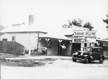
Photograph, Great Western Street Scene 1946
Great Western Street Scene 1946. Man standing outside the house on veranda. Adjoining shop with sign N.E. Houston Storekeeper and three petrol bowsers plus car parked out the front.Black & white photo showing a man standing outside a weather board house with an adjoining shop. A car is parked out the front of the building. N.E. Houston Store keeper Mobil oil Plume (written on the back) Bower's Shop Eric Houston August 14 - 1946stawell -
 Bacchus Marsh & District Historical Society
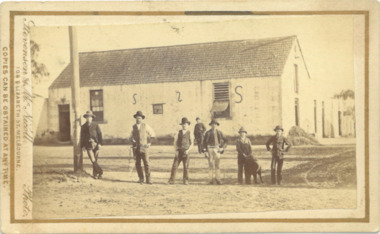
Photograph, Woolpack Stables Bacchus Marsh 1883
This image is one of a series of photographs taken by Melbourne based photographers Stevenson and McNicoll who visited Bacchus Marsh and its nearby districts between September and November 1883. James Elijah Crook settled in Bacchus Marsh in 1841 and soon after held a licence for a lodging house on the Portland Road. In about 1845, he built the first Woolpack Inn, a slab building of eight rooms. This was replaced in 1850 with a “stately country villa” of brick and stone. The stables were also built in 1850 to accommodate twenty horses. In 1851, Crook established a coach service to the goldfields. After being in use as a Court of Petty Sessions, the Woolpack Inn lost its licence and closed in 1862. After this date, Crook took an interest in horse-breeding and continued to use the stables for his horses. His most notable success was with his horse, Saladin, which won the Australia Cup in 1872, after two exciting dead-heats with The Flying Dutchman. James Elijah Crook died in 1889. The Woolpack Inn and Stables were sold and then used as a hay and corn store. In 1910 the site was leased for use as an abattoir. The Woolpack Inn was demolished in 1931. The site is still in use as an abattoir. Little remains of the original stables.Small sepia 'carte de viste' style unframed photograph on card with gold border framing photograph. Housed in the Jeremeas Family Album which contains photographs of Bacchus Marsh and District in 1883 by the photographers Stevenson and McNicoll. The photo is of a gable-roofed commercial stables with shingled roofing, and white-washed render to the walls, standing in a large cleared yard. There is a skillion extension to the south-west corner. On the front (northern) wall can be seen a door and three windows, two large and one small paned window in the centre. The eastern window is paned, while the western window has louvres and a pull-out blind. Three S shaped stays can be seen on the northern wall. Along the western wall are two more windows and doors. A mound of hay lies at the north-western corner. Standing at the front of the stables is a group of five men and two boys, one holding a large dog. Four of the men are dressed in workman’s clothing and some are holding tools of their trade. The man at the back is wearing more formal clothes and has distanced himself from the workmen. The pole against which one of the workmen is leaning appears to have damage along one side. This pole may have been used as a hitching post as there is a footrest installed lower down to make mounting easier. Printed On the front: Stevenson & McNicoll. Photo. 108 Elizabeth St. Melbourne. COPIES CAN BE OBTAINED AT ANY TIME. On the back: LIGHT & TRUTH inscribed on a banner surmounted by a representation of the rising sun. Copies of this Portrait can be had at any time by sending the Name and Post Office Money Order or Stamps for the amount of order to STEVENSON & McNICOLL LATE BENSON & STEVENSON, Photographers. 108 Elizabeth Street, MELBOURNE. stevenson and mcnicoll 1883 photographs of bacchus marsh and district -
 Buninyong Visitor Information Centre
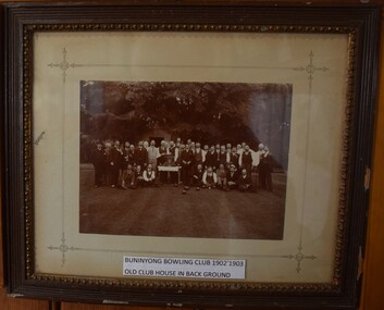
Photograph - Photograph, framed, Buninyong Bowling Club 1902-1903
See images of reverse of frame for an incomplete list of club members in the photograph. The old club house is in the background, now replaced by modern club rooms at the club, which still operates today. The club was formed in 1872 and the old club house was replaced in the 1950s with a larger complex of facilities. This was in turn replaced by another new building in 2011. The club has maintained a strong membership throughout its history. Original black and white mounted and framed photograph of c.40 members of the Buninyong Bowling Club, 1902-1903. Old club house in the background. A list of the names of most people in the photograph provided on the back of the frame. Buninyong Bowling Club 1902-1903. Old club house in background.bowling, sport, buninyong -
 Buninyong Visitor Information Centre
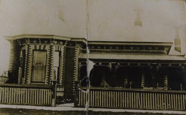
Photograph, The Presbyterian Manse, Scott Street, Buninyong
The manse is located diagonally behind the former Presbyterian Church in Buninyong. The house has been in private hands for over fifty years. Sepia coloured copy of a photograph of the Presbyterian Manse, Scott Street, Buninyong. Image shows the original was torn in two.manses, presbyterian church, heritage listed buildings, buninyong -
 Heidelberg Golf Club
Album - Photograph Album, Heidelberg Golf Club, HGC Clubhouse redevelopment 1998, 1998
Album containing about 186 color photographs of Heidelberg Golf Club's clubhouse redevelopment 1998, including 22 photos of old clubhouse; 94 photos of demolition and construction, 10 of landscaping after the building works and 60 of Opening Day celebrations.Album #6 in the photograph collection at HGCDark green hard cover album. Contains approx. 186 colour photographs 15x10cm.heidelberg golf club, clubhouse redevelopment 1998, club house opening 1998 -
 Heidelberg Golf Club
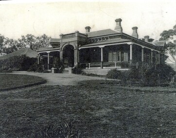
Photograph, Bryn Teg 1927, 1927
Photograph of Mrs Thomas' homestead Bryn Teg around the time it ws acquired by the Heidelberg Golf House Company. It is now the entrance to the Heidelberg Golf Club. The building has been altered over the years but retains some original features.Black and white photograph, possibly a copy of the originalheidelberg golf club, bryn teg -
 Working Heritage Crown Land Collection
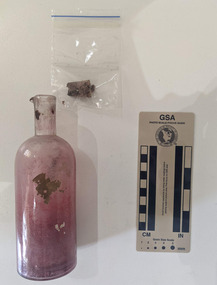
Container - Ink Bottle
... Melbourne Archaeology Historic Building Ballan Court House Hand ...Hand blown master ink bottle with fragments of paper insidearchaeology, historic building, ballan court house -
 Working Heritage Crown Land Collection
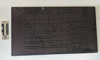
Plaque - former Royal Mint Plaque, The Royal Mint
... and this existing building, which completed the courtyard and housed.... The Guard Houses and this existing building, which completed ...The object is a cast iron plaque.The Melbourne branch of the Royal Mint was established in 1965 after negotiations between Victoria and the British Exchequer. The original site contained 9,763 square meters and included a large area at the rear of the building. On this area, November 16th, 1869, the erection commenced of a single storey building forming three sides of a courtyard and containing workshops, laboratories and coining hall. The Guard Houses and this existing building, which completed the courtyard and housed administrative offices, deputy master's quarters and bullion room followed. All these buildings were designed by J. J. Clark, architect with the Public Works Department. The official opening took place on June 6th, 1872, when the first gold sovereigns were minted. IN 1970 the Public Works Department commenced the restoration and adaptation of this building and the Guard Houses for their present purposes. historic building, former royal mint -
 Working Heritage Crown Land Collection
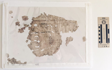
Container - Letter fragment, Ballan Court House letter fragment
... Melbourne Archaeology Historic Building Ballan Court House OHMS ...Fragments of paper that have been removed from the ink bottle. Some printed text is visible. Handwritten text is illegible and written in a different orientation.OHMS: Officer Charge of Police archaeology, historic building, ballan court house -
 Working Heritage Crown Land Collection
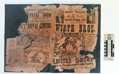
Pamphlet - Wirth Bros show pamphlets, May 18 1898
The pamphlet was found under the floorboards during works to the building Damaged and weathered pamphlets for a Circus and Show by the Wirth Bros Various text and illustrations depicting the activities of the show including horses, tigers and elephants and monkeys. 18th May 1898 historic newspaper, 1898, warracknabeal court house -
 Lakes Entrance Historical Society
Photograph - Skippers Restaurant, 1999c
This building was the original home of the family of George Carpenter, son of John Carpenter, first contractor for construction of the man-made entrance to the lake system, the house was relocated to Hunters Lane, December 2002.Colour photograph of Skippers Restaurant, Esplanade. The photograph shows a weatherboard building, corrugated iron roof, gabled extension at left end, hipped extension at right. Historical evidence shows that the building consists of additions to original smaller residence. Lakes Entrance Victoriaarchitecture, township, restaurant -
 Sunbury Family History and Heritage Society Inc.
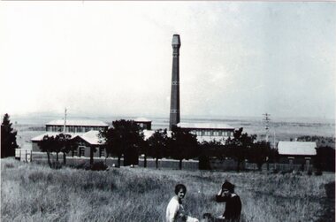
Photograph, Sunbury Asylum Boiler House, C 1920s
The building in the photograph is the Boiler House which was part of the former Sunbury Asylum. It was built in the 1920s to replace an older boiler. Coal and/or briquettes were burned to produce hot water and steam which was used to heat and supply hot water for the Asylum buildings. Steam attendants monitored and maintained the furnace and boiler seven days a week. It ceased production in October 1992 and since then has served as an Arts and Cultural complex for the local community. A non-digital black and white photograph of a large brick building with a tall chimney overlooking open rural countryside with two women sitting on the grass in the foreground. The image has been photographed from an earlier photograph. sunbury asylum, boiler house, arts and cultural complex, performing arts -
 Bendigo Historical Society Inc.
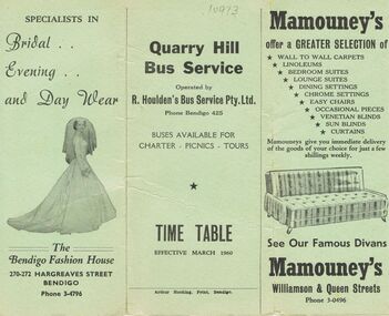
Document - BUS SERVICE TIME TABLE, 1960
BHS CollectionBus Service Time Table: Quarry Hill Bus Service operated by R. Houlden's Bus Service Pty Ltd. Phone Bendigo 424. Buses Available for Charter - Picnics - Tours. Time Table Effective March 1960. Advertising of the tri Fold Brochure is the Bendigo Fashion House 270-272 Hargreaves Street Bendigo Phone 3-47496. Mamouney's home furnishings, Williamson & Queen Streets Phone 3-0496.Fletchers International Food Store 344a Hargreaves St (Opp State Savings Bank) Phone 3-5684. Prime Poultry and Continental and Australian Delicacies. T. Chamberlin canvas and sporting goods. Monumental & Building Masons, Northern Terrazzo Co. Suttons Music Store. Ashman's Men's Shop. Reg. V. Brock Photography. Gillies Bros. Bakery. Miller Bros Deborah Stores Groceries. Box 625Arthur Hocking, Print, Bendigotransport, bus, quarry hill -
 Bendigo Military Museum
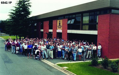
Photograph - 4 Fd Svy Sqn Closure Ceremony 25 Nov 1995, 4 Fd Svy Sqn, Keswick Barracks, Adelaide, 25.11.1995
... the old Squadron building (cavalry stables) now houses the Army... the old Squadron building (cavalry stables) now houses the Army ...Between 1915 and 1951, military topographical mapping in SA was conducted by Royal Australian Survey Corps (RASvy) units based outside the state. In February 1952, Army HQ Field Survey Section (Central Command Detachment) was established in Adelaide in a drill hall at Largs Bay. It was tasked with providing map coverage in the Woomera and Southern areas of the state. The section was subsequently reorganised as Central Command Field Survey Section moving firstly to Hampstead Barracks, Hampstead in 1953 and then into accommodation at Keswick Barracks in 1954. In 1957 the Section commenced mapping operations in the NT. The Unit was relocated to the old cavalry stables in 1961 and was redesignated Central Command Survey Unit and remained there till 1973. In 1970 the Unit was redesignated 4 Fd Svy Sqn and engaged in operations conducted in PNG from 1972 to 1974 inclusive. In 1973 the Squadron moved into a brand new two-storey specially designed and purpose built building adjacent to the old building. The old building then became the Squadron Q and Map store with an interconnecting lobby to the new building. Since 1975 the Unit was involved in the 1:50,000 Mapping Programme in WA, NT, QLD, SA and conducted many other operations within Australia and overseas. Post disbandment of the Corps the old Squadron building (cavalry stables) now houses the Army Museum of South Australia (AMOSA). The Royal Australian Survey Corps was amalgimated into the Royal Australian Engineer Corps in July 1996. In the lead up to this amalgamation, 4 Field Survey Squadron Keswick Barracks, Adelaide, South Australia was disbanded in 1995. A closing Ceremony was held on 25 November 1995 at 4 Fd Svy Sqn Keswick Barracks attended by about 208 former members of the Unit. A photo was taken of attendees at that event on the day and a list was prepared of attendees. All attendees were sent a copy of the photograph and the list of names as a momento of the Unit and the ceremony..1P A4 Print of an original photo of attendees at the 4 Fd Survey Sqn Closure Ceremony at Keswick Barracks 25 Nov 1995. .2P A4 Print of the names of the attendees at the 4 Fd Survey Sqn Closure Ceremony at Keswick Barracks 25 Nov 1995. Approx 208 attendees.royal australian survey corps, rasvy, fortuna, army survey regiment, army svy regt, asr, 4 fd svy sqn -
 Linton and District Historical Society Inc
Photograph, Adams House, Grey Street, Linton
... of the copies says the photo was taken c. 1890. Houses Buildings Adams ...From the "Walk-Drive Tour of Linton", p. 22: ". . . this large Victorian house was originally the home of Hubert Adams, the proprietor of the Grenville Standard from about 1895 until 1909. It was subsequently purchased by the Shire of Grenville and was for many years the Shire Engineer's home." The inscription on the front of one of the copies says the photo was taken c. 1890.Photograph of a timber Victorian style house with a corrugated iron roof. The house has two chimneys and wrought iron decoration on the verandah. An unidentified woman and a young girl are standing in the garden at the front. Adams house, afterwards used as Shire Engineer's house, in Grey Street, LintonOn front of both copies: Shire Engineer's House, Grey St. Linton". On front of copy (a): "c. 1890". On back of copy (b): Shire Engineer's House Grey St Linton".houses, buildings, adams house, shire engineer's house -
 Lakes Entrance Historical Society
Photograph - New Works Jetty, Cooper, Alexander, 1909c
Also black and white copy with ornamental edge 17 x 26.5 cm, and another copy 19.5 x 30 cmBlack and white photograph showing excursion boats at New Works jetties, people on jetties. S S Gippsland tied to jetty on left and another small steamer. P S Tanjil tied to jetty on right. Roofs of works buildings and twin gable roof of J Carpenter's house on right. Several small row boats and small sail boat. Lakes Entrance VictoriaNew Works from Hummocks Cunninghamships and shipping, jetties, tourism -
 Lakes Entrance Historical Society
Postcard - New Works, Bulmer H D, 1910c
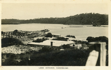
Also second copy same sizeBlack and white postcard showing view of Works buildings and north end of eastern pier. Cunninghame Arm and tip of Bullock Island and groyne work on right. Reeves channel and tip of Rigby Island on left. Mt Barkly and Kalimna Hills in background. Photo taken from top of dune. Roof of Carstairs boarding house centre foreground. Lakes Entrance VictoriaLakes Entrance, Cunninghamewaterways, settlement, historic buildings -
 Lakes Entrance Historical Society
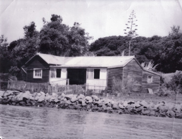
Photograph - Carpentertown, 1900c
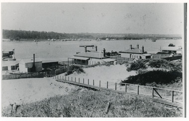
Also four other black and white copies, one size 12 x 18 cm, two size 9 x 14 cm, and one size 10 x 15 cm, one of which was purchased from Helen ClothierBlack and white photograph showing buildings on dunes, and township of Lakes Entrance across lake, Cunninghame Arm. Buildings from left are school, harbour masters house, harbour engineer's house. Boardwalk in foreground. Kalimna Hill in background. Lakes Entrance Victoriawaterways, vegetation, topography, township, historic buildings -
 Linton and District Historical Society Inc
Photograph, Linton Court House, circa 1940
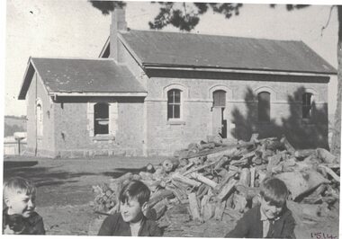
The boys are identified in the typed LDHS index to photographs as, L-R: Vincent McDonald, Ian Morrissey, Allan McDonald.Black and white photograph which shows Linton Court House as it was around 1940. Three boys are in the foreground, a pile of building rubble in the middle ground.linton court house, vincent mcdonald, ian morrissey, allan mcdonald -
 Linton and District Historical Society Inc
Photograph, Miner's Cottage, Woady Yaloak District
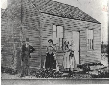
... Buildings Houses Typed on a piece of paper attached to back ...Black and white copy of original photograph which shows a timber cottage with two windows at the front, one each side of a fairly narrow central door. The house has no awning or verandah. It has a shingle roof, and a chimney on one side. A man, two women and a child are outside the front of the house. The man is wearing a waistcoat, tie, jacket and bowler hat, and he is holding a clarinet. The two women are wearing aprons and one of them is holding the child. The location of the house, date of the photograph and the identities of the people in it are unknown.Typed on a piece of paper attached to back of the photograph: "Early wooden miner's cottage, Woady Yaloak District".buildings, houses -
 Lakes Entrance Historical Society
Photograph - Schnapper Cottage, 1944
Black and white photograph showing, Schnapper cottage on western side of entrance. Dark weatherboards, front partially screened in, picket fence along front, rocks along shoreline, thick vegetation on dunes, tall century plant at rear of house. Lakes Entrance Victoria waterfront, historic buildings -
 Warrnambool and District Historical Society Inc.
Administrative record - Exercise Book with details of World Record Marathon Dancing, 1930
This exercise book records the details of Jack Ashworth's attempt to break the world record for marathon dancing in 1930. The event was held in the Oddfellows Hall in Warrnambool from 5.30 a.m. Monday June 23rd to 11.30 p.m. Saturday 28th June 1930 and broke the world record when 138 hours of dancing were completed. Mr Ashworth thus took back the world record which he held on 1929 and later lost. The event was open to the paying public and a prize of one guinea was offered to the lady who danced the longest with Mr Ashworth. The record book shows the signatures of those who verified the continuous dancing at given times throughout the six days. The Oddfellows Hall building in Koroit Street, Warrnambool is still extant and houses local businesses. This item is of particular interest as it contains details of an unusual event in Warrnambool's history.This is an exercise book with a black cloth cover. The pages are edged in red and have ruled blue lines, handwriting in black ink, two newspaper cuttings and a pasted-in poster.jack ashworth, oddfellows hall warrnambool, world record for marathon dancing -
 Warrnambool and District Historical Society Inc.
Administrative record (Collection) - Warrnambool Hospital Records, Warrnambool Hospital Records
Records handed to the Warrnambool & District Historical Society by Warrnambool Hospital AuthoritiesEnsuring maintenance and preservation of Warrnambool Hospital recordsLedgers and other material kept in A3 Archival boxes and housed on shelves in the W.D.H.S. Archives RoomLedgers and other Historical records of the Warrnambool Hospital including Letter Books, Annual Reports, Cash Books, Admissions, Donors' Registers, Receipts and Expenditure Registers and Committee Minute Bookswarrnambool hospital and benevolent asylum, warrnambool base hospital, south west health carewarrnambool hospital and benevolent asylum, warrnambool base hospital, south west health care -
 Warrnambool and District Historical Society Inc.
Archive (Collection) - A.A. Briggs collection of ledgers and personal papers, Arthur Briggs, Personal Papers, 1893-1937
Administrative records of A. A. Briggs, Warrnambool accountant, real estate agent, insurance and commission agent donated to the Warrnambool and District Historical Society, source and date unknown byadministrative records of a Warrnambool businessmanNine ledgers and four folders of documents held in A3 archival boxesHandwritten administrative records and personal papers of nine ledgers and four foldersa.a. briggs warrnambool, victorian alliance, atlas assurance company, warrnambool hospital, warrnambool permanent building societya.a. briggs warrnambool, victorian alliance, atlas assurance company, warrnambool hospital, warrnambool permanent building society -
 Linton and District Historical Society Inc
Photograph, Piggoreet Township
Piggoreet Township developed very quickly after gold was discovered in the Springdallah area (at that time called Spindella) in the 1850s. By the early 1860s the township had a population in the hundreds, as well as shops, a school, a police station and court house, hotels and churches.Copy of original photograph which shows roads, buildings, general layout of the former township at Piggoreet.piggoreet township -
 Eltham District Historical Society Inc
Photograph - Digital Photograph, Alan King, Panton Hill Hotel, 27 March 2008
Today’s Panton Hill Hotel was built around 1920. Published: Nillumbik Now and Then / Marguerite Marshall 2008; photographs Alan King with Marguerite Marshall.; p61 Panton Hill was originally known as Kingstown, and consisted of only one hotel when the Orams Reef was discovered in 1859. Kingstown was a quartz mining centre and many old mine shafts remain in the area. Orams Reef was one of the first reefs with a rich find of gold in the area. The Hotel Francais, which had been operating in 1861, was well situated on the way to Queenstown (later St Andrews). So was Herr Hirt’s Hotel and store at Smiths Gully. The Kingstown hotel, known as the Frenchman’s and in 1864 as the Hotel de France, was run by a Monsieur Emile Hude and his wife Jeanne, and known for its good food. They hosted social events, business conventions and debates, attracting patrons from as far as Melbourne. The hotel’s name was changed to Panton Hill Hotel in 1905. In 1883 Charles Caudwell built another hotel nearby, possibly in Long Gully Road,3 which it is thought, was burnt down early last century. Today’s Panton Hill Hotel, built around 1920, is the only one of the cluster of buildings in the main road, not to date from around the turn of last century. It was severely damaged by fire in 2003, then underwent extensive alterations. It is the township’s only hotel and is an example of a modest hotel building exterior, constructed early last century. In its early days the hotel also housed the first post office, newsagency and store. Orams Reef yielded a total of £100,000, and fossikers also found alluvial gold in the creeks and gullies, but there is no record of the total value of their finds. Gold greatly increased the Panton Hill population, which peaked between 1865 and 1885. On holidays large sports meetings were held with wood chopping contests and foot races and the day would end with a ball. Miners came from various countries to seek their fortune, including many from China. The Chinese became unpopular however, and gradually left the district, although some stayed and grew and sold vegetables.5 Panton Hill was named after Joseph Panton, who in 1862 was appointed Police Magistrate for the Woods Point, Heidelberg and Yarra districts. Panton was an outstanding man, who in 1852, was Commissioner of Crown Lands and Assistant Commissioner of Goldfields at Bendigo. In 1874 he was promoted to Chief Magistrate for the Melbourne Police. Panton was also an artist, becoming president of the Victorian Arts Society in 1888, and in 1913, president of the Royal Geographical Society. Despite Panton Hill’s prosperity, it still lacked many services as poor roads made access to Melbourne difficult. A horse-drawn mail coach travelled to Melbourne until 1890, when the railway came to Heidelberg. The nearest doctor was at Yarra Glen or Heidelberg, and the Indian hawker Singh’s annual visit was very welcome. A miner’s shack opposite the school was used as a post office. Today’s general store and post office in the main road dates from early last century, and has changed considerably. While most people searched for gold, the more enterprising ones established farms to feed the diggers. Farmers grew wheat, barley and oats, and sent animal skins to the Eltham tannery, to make furs in Melbourne. As gold became scarce from around 1880, miners took up farming on 19 to 20 acre (8ha) allotments. The first settlers in Cherry Tree Road included Purcell, Smith, Owens, Hughes and Shillinglaw. By 1900 all the land had been taken up around Panton Hill and Hurstbridge. The orchards in Panton Hill and the wider district, particularly of apple and pear, were very successful, and made Panton Hill a cohesive and successful community. About 1914 the Moores built the first cool-store and refrigeration plant at their orchard in Cherry Tree Road. Many settlers planted vineyards and made high quality wine, but in 1922 the blight destroyed them.This collection of almost 130 photos about places and people within the Shire of Nillumbik, an urban and rural municipality in Melbourne's north, contributes to an understanding of the history of the Shire. Published in 2008 immediately prior to the Black Saturday bushfires of February 7, 2009, it documents sites that were impacted, and in some cases destroyed by the fires. It includes photographs taken especially for the publication, creating a unique time capsule representing the Shire in the early 21st century. It remains the most recent comprehenesive publication devoted to the Shire's history connecting local residents to the past. nillumbik now and then (marshall-king) collection, panton hill hotel -
 Glen Eira Historical Society
Document - Historic Conservation Areas Project
Contains 4 items relating to historic conservation: 1/Five newsletters (one page each newsletter, dated 07/1975, 08/1975, 09/1975, 10/1975 and the final one 12/1975) describing how the project evolved, project funds, progress, study method, project 1 report, project 2 report and summary as no further funds available. Project was to include all of Melbourne but funding did not allow this. Note: newsletters stamped with Caulfield Historical Society. 2/Letter (one page on official city of Caulfield letterhead) from Andrew Rodda (manager planning) to Hazal Ford (dated 13/11/1989) describing ‘council resolved on 18/07/1989 to proceed with preliminary conservation survey’ and mentions that a copy is included. 3/Preliminary conservation survey for the City of Caulfield (nine pages) describing background, study area, budget, purpose, study outline, timeframe, report format, ownership, tasks and background information (mentions number and types of houses and properties as at 1986 and 1988) and a map of City of Caulfield. 4/Booklet (28 pages) titled ‘Heritage Area – Caulfield North Draft Heritage Guidelines July 1999 – City of Glen Eira’, containing Caulfield North Heritage Area, cultural heritage, Heritage Overlay Area, architectural description, common architectural forms and features, development guidelines, key design checklist. It includes a map of the Caulfield North Heritage Overlay Area, two illustrations about the development envelope and many black-and-white photographs of houses and architectural features.historic conservation areas project niven barbara, newsletters, town planning, historic buildings, heritage studies, housing, royal historical society of victoria (rhsv), read michael, plans, local government, historical societies, committee for urban action (cua), national trust, hopkins sherry ms., ford hazel, preliminary conservation survey, town planning, heritage studies, rodda andrew, city of caulfield, housing estates, victoria national estate grants program, australia icomos, burra charter, buildings structures and establishments, land surveys, suburbs, historic buildings, architectural significance, ‘caulfield’s heritage study’, soloman geulah dr., caulfield library, dandenong road, nepean highway, hotham street, iknerman road, orrong road, north road, poath road, ‘plan of the city of caulfield’, north ward, east ward, south ward, west ward, kooyong road, neerim road, bambra road, balaclava road, shire of caulfield, railways, world war 1914-1918, depression 1929-1939, rippon lea, labassa, parks, mansions, community services, ‘caulfield north draft heritage guidelines july 1999’, city of glen eira, caulfield north heritage area, glen eira heritage management plan, mayfield grove, normanby avenue, carnarvon street, glenferrie street, arthur street, malakoff street, normanby road, heritage advisory service, construction materials, victorian style, mediterranean style, spanish mission style, californian bungalow style, federation style, architectural style, architectural features, heritage conservation design, building construction, building regulations, aboriginal peoples, carnarvon road -
 Linton and District Historical Society Inc
Photograph, Bird Family Home, Scarsdale
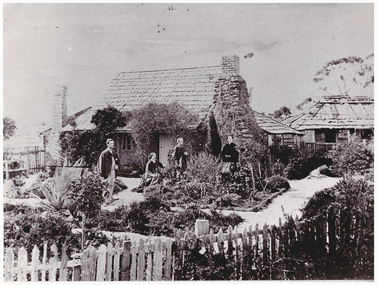
Black and white copy of original photograph showing two men and two women standing outside a house with a shingled roof and two stone chimneys. In front of the house are garden beds and a picket fence. Out building is in the background."Bird family - first home in Scarsdale."bird family, scarsdale, family home -
 Linton and District Historical Society Inc
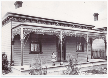
Photograph, Home of Ernest Ball, Sussex Street, Linton
... ). Ernest Ball Buildings Houses 46 Sussex Street Linton Black ...Photograph shows the home of Ernest Ball and his wife Fanny, née Aust. The small child standing on the verandah has been identified as their daughter Mavis Ball (afterwards Mavis Ruglen).Black and white copy of original photograph showing a double-fronted house with a verandah. A young girl is standing on the verandah. House has decorative trim and iron lace on verandah.ernest ball, buildings, houses, 46 sussex street linton -
 Lakes Entrance Historical Society
Photograph - Butcher's Paddock, Hanlon, Vera, 1940c
Historic home at 90 Captenter St 'Corrumbene' is pictured on right hand side of photograph. Godsell's house opposite on Western side of North ArmBlack and white photograph showing view of lower reaches of North Arm, part of town, Cunninghame Arm and sand dunes in background, and North Arm on right. Photo taken from Allens Hill, Myer St, vacant paddocks in foreground, known as Butcher's Paddock, slaughterhouse and buildings in mid view. Lakes Entrance Victoriatownship, waterways, animals