Showing 10466 items
matching sections
-
 Ballarat Tramway Museum
Document - Folder with papers, Robert Ashley, "Ballarat SEC History", 1989
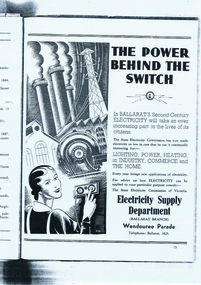
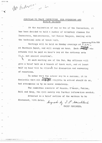
Samizone flat file, made from manila card with blue printing for file details and a Dymo machine label on the spine (red background with white printing) titled "Ballarat SEC History". On inside of folder is a "Post It" note with handwriting "Robert Ashley Ex Employee" in blue ink. Contained within folder is" 1. "Ballarat, Electricity and the State Electricity Commission" photocopied from an original. Has typed under the heading over white out correction fluid "Notes - Draft notes prepared by Robert W. P. Ashley 1989." The paper gives the history of power supply in Ballarat, including street lighting, ESCo, AC and DC power supplies, the takeover by the SEC, Ballarat A and B power stations, a copy of an advertisement for the SEC in Ballarat. (See btm1701i3.jpg) titled "The Power Behind the Switch" 2. Paper by A. D. Senior, titled "Electricity Supply in Ballarat" - see Reg. Item No. 1700. (see btm1700i.pdf) 3. Photocopied onto foolscap paper of an extract from possibly a large report on power supply in Victoria. Pages 155 to 158. Reports on the history of the power supply system in Ballarat until the takeover of ESCo by the SEC. Further details are referred to another section of the Report on the SEC itself. On page 158 are details of Beaufort Council operated supply and the start of notes on Beechworth. (see btm1701i2.pdf) Images of files added 6-8-15 For an image of the advert itself see btm1701i3.pdfSee notes above.trams, tramways, secv, power supply, esco, beaufort -
 Ballarat Tramway Museum
Document - Lecture Notes, Metropolitan Transit Authority (MTA), "Tramway Permanent Way", 1987
Seventy two page photocopied document within card covers and outer plastic covers with an additional introduction page between front clear plastic cover and card cover bound with a white comb binder. Book titled "Tramway Permanent Way" presenting a series of lectures by MMTB Per Way officers in 1928 at Hawthorn Depot. Contents in order: 1. Handwritten note from Chris Jacobson on Metropolitan Transit Authority of Victoria memo paper forwarding a copy to Warren Doubleday of the BTPS in Feb. 1988, with date received stamp at depot of 19/2/1988. 2. Photocopy of a memo on Metropolitan Transit letterhead from K. C. Painter dated 20/7/1987 to the Civil Engineering Design drafting staff forwarding a copy of the 1928 lectures to the then current staff. 3. Photocopy of a circular from J.P. Strickland, Chief Engineer to track inspectors, sub overseers, overseers and senior gangers advising that a series of weekly lectures on track work would be held at Hawthorn Depot commencing 23/1/1928. 4. Lecture notes: 1. Interpretation of Drawings 2. Alignment etc 3. Alignment continued and special work 4. The drainage system 5. Concrete 6. Rails and Fastenings 7. Welding 8. Timber 9. Paving and paving materials 10. Track cross sections. Second copy added 27/11/2010 - ex PPW holdings. Both items transferred to Box 99.\ Scanned copy added 15-12-2016.trams, tramways, trackwork, mmtb, lectures, tramway per way, training -
 Ballarat Tramway Museum
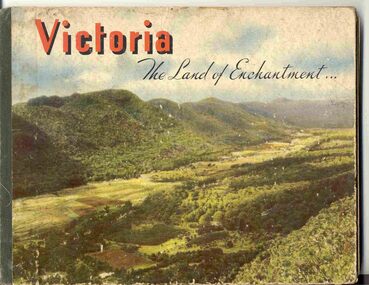
Book, Nu-color-vue or Nucolorvue Productions, "Victoria The Land of Enchantment", c1950
Book with hardcovers, 48 pages titled "Victoria The Land of Enchantment". Sewn in three sections, with a green strip of cloth and self end papers and printed outer paper, sides glued onto board covers. Consists of 43 colour photographs (full and half page) with captions, detailed text, and two black and white photos printed in blue on end covers. Photos of Mt Buffalo, Gippsland lakes, Mornington Beach, Yarra River, Flinders St. station from the Yarra, Collins and Spring St (with two W2's - see image No. 2), Parliament House, Kiewa Hydro scheme, Eildon Weir, Swan Hill Murray River Bridge, Bendigo Post Office, Melbourne Botanical Gardens, Ballarat - Grenville and Sturt St (No. 22 - see image No. 3), Lorne, Yallourn Power Station, Hume Weir, Maroondah Weir, Great Ocean Road, Warrnambool, Portland Beach, A timber train (see image No. 4), Mildura, flax mills, Eastern Geelong and the Prime Ministers Ave, Ballarat. Produced by Nucolorvue Productions, c1950. See also Reg Item 2925 for the same photo of No. 22 and Reg Item 5354 for a postcard. Purchased via eBay site - see attached sheets and packing slip. Purchased 10/2/2005 for A$12.50 including postage, from Virginia Georgopoulos of West Brunswick. eBay sheets and envelope with worksheet file. Has Swains 123 Pitt St, Sydney sticker on bottom left hand corner page 2trams, tramways, ballarat, sturt st, grenville st, bogie trams, geelong, bendigo, melbourne -
 Ballarat Tramway Museum
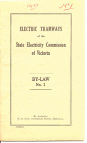
Book, State Electricity Commission of Victoria (SECV), "Electric Tramways of the State Electricity Commission of Victoria By-Law No. 1", 1943
Demonstrates aspects of the SEC governance system in issuing By-laws for the travelling public, as part of their Act. Yields information about fares charged for tram services in Ballarat, Bendigo and Geelong. Issued to crews.Twenty Four page booklet, plus medium weight card brown colour covers centre stapled. Book cover has title "Electric Tramways of the State Electricity Commission of Victoria By-Law No. 1". Pages are numbered pages 1 to 24, revoking By Laws dated 5/9/1932 (See Reg. Item 3109). Dated 9/3/1937. Gives definitions, fares and charges, regulations re passengers, behaviour, smoking, dangerous goods, luggage and behaviour of crews. Gives schedule of fares and charges for Ballarat, Bendigo and Geelong. Fares applied from 1937 to 1949 - see Reference. Details names of SEC Commissioners, Minister in Charge of Electrical Undertakings. Four copies held. Copy 1 - as printed. Copy 2 - has numerous changes marked in red ink internally and pasted in changes to the text. The schedules have been crossed out. Copy 3 - has changes marked in black ink, including fare and charges changes that were made in 1949. No pasted in sections. Copy 4 - missing back cover. Copy 5 - missing front and back pages. Has Government Printer, H. E. Daw, number 11928/43. Given the printing number on Reg. Item 3110 is a lower number and that the H. Green was the Government Printer in 1936 (See Reg. Item 3068), "43" indicates a reprinting date. See Fares in Ballarat – from Alan Bradley 11/4/2005 – appendix for Book Copy 1 - has "1937" and "No. 1" written in red ink on top of cover. Copy 2 - has "No. 2" written in red ink in top right hand corner of cover and "Ballarat Tramway Preservation Society No. 202" written in black ink on top of cover and numerous changes marked in red ink internally and pasted in changes to the text. The schedules have been crossed out in red ink. Copy 3 - has "Ballarat Tramway Preservation Society No. 202" written in black ink on top of cover and numerous changes marked in black ink including changes to fares and schedules.trams, tramways, secv rules, by laws, tickets, fares, ballarat, bendigo, geelong -
 Kew Historical Society Inc
Plan, Borough of Kew Detail Plan No.1577, 1904
The Melbourne and Metropolitan Board of Works (MMBW) plans were produced from the 1890s to the 1950s. They were crucial to the design and development of Melbourne's sewerage and drainage system. The plans, at a scale of 40 feet to 1 inch (1:480), provide a detailed historical record of Melbourne streetscapes and environmental features. Each plan covers one or two street blocks (roughly six streets), showing details of buildings, including garden layouts and ownership boundaries, and features such as laneways, drains, bridges, parks, municipal boundaries and other prominent landmarks as they existed at the time each plan was produced. (Source: State Library of Victoria)This plan forms part of a large group of MMBW plans and maps that was donated to the Society by the Mr Poulter, City Engineer of the City of Kew in 1989. Within this collection, thirty-five hand-coloured plans, backed with linen, are of statewide significance as they include annotations that provide details of construction materials used in buildings in the first decade of the 20th century as well as additional information about land ownership and usage. The copies in the Public Record Office Victoria and the State Library of Victoria are monochrome versions which do not denote building materials so that the maps in this collection are invaluable and unique tools for researchers and heritage consultants. A number of the plans are not held in the collection of the State Library of Victoria so they have the additional attribute of rarity.Original survey plan, issued by the MMBW to a contractor with responsibility for constructing sewers in the area identified on the plan within the Borough of Kew. The plan was at some stage hand-coloured, possibly by the contractor, but more likely by officers working in the Engineering Department of the Borough and later Town, then City of Kew. The hand-coloured sections of buildings on the plan were used to denote masonry or brick constructions (pink), weatherboard constructions (yellow), and public buildings (grey). MMBW Plan No.1577 includes some of the most significant houses in Kew: Herbert Henty’s ‘Roxeth’ (now part of Trinity Grammar), ‘Butleigh Wooton’, ‘Bokara’ and ‘Harrow’. It also includes the streets that have since changed their names. That part of College Parade linked to Glenferrie Road is now named College Place, College Parade now extends further north, and Charles Street did not yet reach Barkers Road. Roxeth is one of a number of Henty houses in Kew. Herbert Henty made his home here and was elected a member of Kew Municipal Council in 1864 and mayor in 1868-69. Walter Henry Serle, of Harrow served in the First World War. He was awarded the Military Medal ‘’For conspicuous bravery and devotion to duty. On 29th September near BELLICOURT he showed the greatest bravery and determination when his platoon was attacked by enemy bombing parties. It was due largely to his personal efforts that all the attacks were repulsed. Until wounded, his utter disregard of personal safety and boldness in dealing with the attacks were the means of saving the situation and were an inspiring example to his men.’melbourne and metropolitan board of works, detail plans, maps - borough of kew, mmbw 1577, cartography -
 Kew Historical Society Inc
Plan, Melbourne and Metropolitan Board of Works, Borough of Kew : Detail Plan No.1580, 1904
The Melbourne and Metropolitan Board of Works (MMBW) plans were produced from the 1890s to the 1950s. They were crucial to the design and development of Melbourne's sewerage and drainage system. The plans, at a scale of 40 feet to 1 inch (1:480), provide a detailed historical record of Melbourne streetscapes and environmental features. Each plan covers one or two street blocks (roughly six streets), showing details of buildings, including garden layouts and ownership boundaries, and features such as laneways, drains, bridges, parks, municipal boundaries and other prominent landmarks as they existed at the time each plan was produced. (Source: State Library of Victoria)This plan forms part of a large group of MMBW plans and maps that was donated to the Society by the Mr Poulter, City Engineer of the City of Kew in 1989. Within this collection, thirty-five hand-coloured plans, backed with linen, are of statewide significance as they include annotations that provide details of construction materials used in buildings in the first decade of the 20th century as well as additional information about land ownership and usage. The copies in the Public Record Office Victoria and the State Library of Victoria are monochrome versions which do not denote building materials so that the maps in this collection are invaluable and unique tools for researchers and heritage consultants. A number of the plans are not held in the collection of the State Library of Victoria so they have the additional attribute of rarity.Original survey plan, issued by the MMBW to a contractor with responsibility for constructing sewers in the area identified on the plan within the Borough of Kew. The plan was at some stage hand-coloured, possibly by the contractor, but more likely by officers working in the Engineering Department of the Borough and later Town, then City of Kew. The hand-coloured sections of buildings on the plan were used to denote masonry or brick constructions (pink), weatherboard constructions (yellow), and public buildings (grey). The area represented in this detail plan has undergone significant change during the 20th century. The widening of High Street in the 1930s and 1950s involved the shops on the south side of High Street being demolished and later rebuilt to fit the widened street. Another significant loss was the mansion ‘Drayton’ fronting Wellington Street, owned at this stage by Susannah Fenton. Her family name would later to be given to Fenton Way, which was to be built over the grounds of the house following its demolition. The plan of the garden is particularly interesting, containing a batten dome fronting Wellington Street, an ornamental pond, a fountain and a brick and glass conservatory. The notes by the plumbing contractor on this plan are particularly detailed. Pink borders delineate the ownership of the varying parcels of land. Some of the better known owners listed include the real estate agent Cr. Henry de Castres Kellett (bt) and John Padbury, the funeral director. This particular plan provides a clear view of the configuration of the Kew Junction in 1903 and the commercial buildings that surrounded it.melbourne and metropolitan board of works, detail plans, maps - borough of kew, mmbw 1580, cartography -
 Kew Historical Society Inc
Plan, Melbourne & Metropolitan Board of Works : Borough of Kew : Detail Plan No.1582, 1904
The Melbourne and Metropolitan Board of Works (MMBW) plans were produced from the 1890s to the 1950s. They were crucial to the design and development of Melbourne's sewerage and drainage system. The plans, at a scale of 40 feet to 1 inch (1:480), provide a detailed historical record of Melbourne streetscapes and environmental features. Each plan covers one or two street blocks (roughly six streets), showing details of buildings, including garden layouts and ownership boundaries, and features such as laneways, drains, bridges, parks, municipal boundaries and other prominent landmarks as they existed at the time each plan was produced. (Source: State Library of Victoria)This plan forms part of a large group of MMBW plans and maps that was donated to the Society by the Mr Poulter, City Engineer of the City of Kew in 1989. Within this collection, thirty-five hand-coloured plans, backed with linen, are of statewide significance as they include annotations that provide details of construction materials used in buildings in the first decade of the 20th century as well as additional information about land ownership and usage. The copies in the Public Record Office Victoria and the State Library of Victoria are monochrome versions which do not denote building materials so that the maps in this collection are invaluable and unique tools for researchers and heritage consultants. A number of the plans are not held in the collection of the State Library of Victoria so they have the additional attribute of rarity.Original survey plan, issued by the MMBW to a contractor with responsibility for constructing sewers in the area identified on the plan within the Borough of Kew. The plan was at some stage hand-coloured, possibly by the contractor, but more likely by officers working in the Engineering Department of the Borough and later Town, then City of Kew. The hand-coloured sections of buildings on the plan were used to denote masonry or brick constructions (pink), weatherboard constructions (yellow), and public buildings (grey). Public buildings, coloured grey on the Plan 1582 include the police station and post office, churches and schools. The earliest church school, Common School No.356 was located at the rear of the Congregational Church in Peel Street. It was constructed in 1859. The first buildings of Kew Primary School No.1075 on the other side of Peel Street were constructed in 1871. The school in 1903 only occupied a small fraction of its current site. In 1903, where the rear playground is now located, were two weatherboard and one brick villa. Trinity Grammar School was founded in 1902 and opened in the Parish Hall at the rear of Holy Trinity Anglican Church. It was not to move to its current site until 1906. The outline of the building housing the Kew Fire Brigade in the centre of the north side of Walton Street is shown but not named on the plan. Further down Pakington Street stood the two-storey Italianate mansion ‘Overton’. The home of Stanford Chapman, it was to be featured in the Imperial Institute series of bromide photographs of Victoria, Vol. 1: Homes and scenery. It was later to become a boarding house before it was later demolished.melbourne and metropolitan board of works, detail plans, maps - borough of kew, mmbw 1582, cartography -
 Kew Historical Society Inc
Plan, Melbourne & Metropolitan Board of Works : Borough of Kew : Detail Plan No.1585, 1904
The Melbourne and Metropolitan Board of Works (MMBW) plans were produced from the 1890s to the 1950s. They were crucial to the design and development of Melbourne's sewerage and drainage system. The plans, at a scale of 40 feet to 1 inch (1:480), provide a detailed historical record of Melbourne streetscapes and environmental features. Each plan covers one or two street blocks (roughly six streets), showing details of buildings, including garden layouts and ownership boundaries, and features such as laneways, drains, bridges, parks, municipal boundaries and other prominent landmarks as they existed at the time each plan was produced. (Source: State Library of Victoria)This plan forms part of a large group of MMBW plans and maps that was donated to the Society by the Mr Poulter, City Engineer of the City of Kew in 1989. Within this collection, thirty-five hand-coloured plans, backed with linen, are of statewide significance as they include annotations that provide details of construction materials used in buildings in the first decade of the 20th century as well as additional information about land ownership and usage. The copies in the Public Record Office Victoria and the State Library of Victoria are monochrome versions which do not denote building materials so that the maps in this collection are invaluable and unique tools for researchers and heritage consultants. A number of the plans are not held in the collection of the State Library of Victoria so they have the additional attribute of rarity.Original survey plan, issued by the MMBW to a contractor with responsibility for constructing sewers in the area identified on the plan within the Borough of Kew. The plan was at some stage hand-coloured, possibly by the contractor, but more likely by officers working in the Engineering Department of the Borough and later Town, then City of Kew. The hand-coloured sections of buildings on the plan were used to denote masonry or brick constructions (pink), weatherboard constructions (yellow), and public buildings (grey). This plan, which covers parts of High Street, Pakington Street and Derby Street is dominated by two historic Kew mansions: ‘Konetta’ and ‘Ramornie’. Ramornie was constructed in 1890 for James Maitland Campbell, three times Mayor of Kew. Sold in 1940, it became a boarding house known as ‘The Towers’. Now a private residence again, it has only one of its three balconies remaining. The location of the missing two balconies can be seen on the plan. In 1903, the grounds of Ramornie included a large tennis court fronting Pakington Street. The rear of the property is shown as extending to Cobden Street. One of Kew’s oldest hotels, the Prospect Hill Hotel on the corner of High and Cobden Street was established in 1858. The outline of the hotel shown on the plan represents the second building on the site. During the 19th century it was often used for electoral meetings. The Prospect Hill Hotel was to be redeveloped again in 1928, by the local architect Robert McIntyre. Since the 1980s, the hotel has been a live music venue, the home of the Melbourne Jazz Club, a restaurant and a liquor outlet.melbourne and metropolitan board of works, detail plans, maps - borough of kew, mmbw 1585, cartography -
 Kew Historical Society Inc
Plan, Melbourne & Metropolitan Board of Works : Borough of Kew : Detail Plan No.1588, 1904
The Melbourne and Metropolitan Board of Works (MMBW) plans were produced from the 1890s to the 1950s. They were crucial to the design and development of Melbourne's sewerage and drainage system. The plans, at a scale of 40 feet to 1 inch (1:480), provide a detailed historical record of Melbourne streetscapes and environmental features. Each plan covers one or two street blocks (roughly six streets), showing details of buildings, including garden layouts and ownership boundaries, and features such as laneways, drains, bridges, parks, municipal boundaries and other prominent landmarks as they existed at the time each plan was produced. (Source: State Library of Victoria)This plan forms part of a large group of MMBW plans and maps that was donated to the Society by the Mr Poulter, City Engineer of the City of Kew in 1989. Within this collection, thirty-five hand-coloured plans, backed with linen, are of statewide significance as they include annotations that provide details of construction materials used in buildings in the first decade of the 20th century as well as additional information about land ownership and usage. The copies in the Public Record Office Victoria and the State Library of Victoria are monochrome versions which do not denote building materials so that the maps in this collection are invaluable and unique tools for researchers and heritage consultants. A number of the plans are not held in the collection of the State Library of Victoria so they have the additional attribute of rarity.Original survey plan, issued by the MMBW to a contractor with responsibility for constructing sewers in the area identified on the plan within the Borough of Kew. The plan was at some stage hand-coloured, possibly by the contractor, but more likely by officers working in the Engineering Department of the Borough and later Town, then City of Kew. The hand-coloured sections of buildings on the plan were used to denote masonry or brick constructions (pink), weatherboard constructions (yellow), and public buildings (grey). This plan shows the original configuration of the Kew Post Office, Court House and Police Station, which had opened in 1888. This configuration was to essentially remain until the purchase of the Court House and Police Station by the City of Boroondara in 2007 and its subsequent renovation. Interestingly, the MMBW surveyors incorrectly labelled parts of the complex. In the triangle in front of the Post Office, before the erection of the Kew Cenotaph in 1925, was located a lawn and the Queen Victoria Jubilee Fountain. While many of the shops on the south side of High street had been constructed by 1903 a number of sites were still used as vegetable gardens. Further along High Street, on the corner of Charles Street, the Salvation Army Barracks can be seen on the plan. These Barracks predate the later Citadel and ‘Young People’s Hall’ that were opened in 1919. At 22 Charles Street can be seen the house of James Venn Morgan. Hailed as the ‘father of Kew’, Morgan arrived in Melbourne in 1840. He was first engaged as a bookmaker, but a fortunate venture on the goldfields enabled him to purchase land in Kew. He conducted a market garden and dairy in Kew for many years.melbourne and metropolitan board of works, detail plans, maps - borough of kew, mmbw 1588, cartography -
 Kew Historical Society Inc
Plan, Melbourne & Metropolitan Board of Works : Borough of Kew : Detail Plan No.1591, 1905
The Melbourne and Metropolitan Board of Works (MMBW) plans were produced from the 1890s to the 1950s. They were crucial to the design and development of Melbourne's sewerage and drainage system. The plans, at a scale of 40 feet to 1 inch (1:480), provide a detailed historical record of Melbourne streetscapes and environmental features. Each plan covers one or two street blocks (roughly six streets), showing details of buildings, including garden layouts and ownership boundaries, and features such as laneways, drains, bridges, parks, municipal boundaries and other prominent landmarks as they existed at the time each plan was produced. (Source: State Library of Victoria)This plan forms part of a large group of MMBW plans and maps that was donated to the Society by the Mr Poulter, City Engineer of the City of Kew in 1989. Within this collection, thirty-five hand-coloured plans, backed with linen, are of statewide significance as they include annotations that provide details of construction materials used in buildings in the first decade of the 20th century as well as additional information about land ownership and usage. The copies in the Public Record Office Victoria and the State Library of Victoria are monochrome versions which do not denote building materials so that the maps in this collection are invaluable and unique tools for researchers and heritage consultants. A number of the plans are not held in the collection of the State Library of Victoria so they have the additional attribute of rarity.Original survey plan, issued by the MMBW to a contractor with responsibility for constructing sewers in the area identified on the plan within the Borough of Kew. The plan was at some stage hand-coloured, possibly by the contractor, but more likely by officers working in the Engineering Department of the Borough and later Town, then City of Kew. The hand-coloured sections of buildings on the plan were used to denote masonry or brick constructions (pink), weatherboard constructions (yellow), and public buildings (grey). That area of Kew bordered by Cotham Road, Park Hill Road, Ermington Lane (now Ermington Place), and Belmont Avenue contained some of the significant homes owned by Kew pioneers. Chief among these was ‘Park Hill’ on an enormous lot facing Park Hill Road. The Jubilee History of 1910 noted, six years after this plan was drawn, that: ‘Park Hill Road, forming the southern boundary of the cemetery, takes its name from Park Hill, the residence of Mr. Thomas Judd, who has resided there since December, 1852.’ Other named houses on the plan include ‘Ferndale’ facing Cotham Road; ‘Ermington’ adjacent to Judd’s Park Hill, facing Park Hill Road; and ‘Gilden’ and ‘Mont Belmont’ facing Belmont Avenue. Mont Belmont was designed by the architectural firm of Reed, Henderson and Smart for William George Lilley in 1887 and was completed in 1888. Lilley was Mayor of Kew in 1887-88, a Justice of the Peace and a member of the first Board of Guardians of Kew’s St. Hilary’s Church of England.melbourne and metropolitan board of works, detail plans, survey plans - borough of kew, mmbw 1591, cartography -
 Kew Historical Society Inc
Album, Alick Kirkland Goulburn Gipps' Scrapbook, 1930s
Alick Gipps (1928-2014) was the son of Richard Brook Woodthorpe Gipps (1872-1946) and Mary Alys Kirkland (1889-1981), and the older brother of Christopher David Gipps (1930-52) and Rosemary Alison Gipps (1930-2013). While many scrapbooks of the period were created by, and or added to by their child owners, it is believed that "scrapbooks were considered by later Victorian parents to be an educational tool to teach children how to organise and classify information and to develop their ‘artistic’ senses" (Margaret Simpson, MAAS, 2008), and that the scrapbooks may have been compiled by the parent, rather than the child.The scrapbook is part of a large and significant collection of items donated by Rosemary Vaughan-Smith, past member and office-bearer of the Kew Historical Society. between 2005-12. The collection includes costumes, scrapbooks, autograph books, artworks and objects.Hard cover, 50-page album covered in red cloth and red leather corners and spine, the latter embossed with the words 'SCRAP BOOK' in gilt lettering. On the inside front cover, top left is an oval green label with retailer information - "WEDDING CHRISTENING / R. E. PENN. / Bible Warehouse / 213 REGENT St / BIRTHDAY PRESENTS". The paper used for the pages are in alternating blue, cream and green-coloured sections. The front pages of the scrapbook include the signature of the owner as Alick Kirkland [Goulburn] Gipps (1928-2014). Items pasted into the scrapbook include black and white and coloured illustrations, photographs, and extracts from books. Items selected for the scrapbook fill a single page or are arranged in groups. The oldest items in the scrapbook appear to date from 1859 and include a colour cover of the Illustrated London Almanack and pictorial handbills of electoral results for the seat of Holmesdale and Filmer in Kent, England. While other items in the book are of later periods, most can be classified as sentimental Victorian-era illustrations. The biblical scenes in the scrapbook reflect one aspect of the values of the Gipps family. The focus in the album on material about or published in Great Britain also suggests a preoccupation with, and a valuing of, traditional British culture. This is confirmed by the memberships of Alick and his sister Rosemary (Gipps) Vaughan-Smith in the English-Speaking Union Club, for which they welcomed guests at an 'Elizabethan party and barbecue' during the Coronation festivities of June 1953. (The Age, 3 June 1953, page 5). The album entered the collection of the Kew Historical Society as part of the Raymond and Rosemary (Gipps) Vaughan-Smith donation.manuscripts - kew historical society, rosemary vaughan-smith, vaughan-smith collection, alick kirkland goulburn gipps, scrapbooks - 20th century -
 Kew Historical Society Inc
Plan, Melbourne & Metropolitan Board of Works : Borough of Kew : Detail Plan No.1563, 1905
The Melbourne and Metropolitan Board of Works (MMBW) plans were produced from the 1890s to the 1950s. They were crucial to the design and development of Melbourne's sewerage and drainage system. The plans, at a scale of 40 feet to 1 inch (1:480), provide a detailed historical record of Melbourne streetscapes and environmental features. Each plan covers one or two street blocks (roughly six streets), showing details of buildings, including garden layouts and ownership boundaries, and features such as laneways, drains, bridges, parks, municipal boundaries and other prominent landmarks as they existed at the time each plan was produced. (Source: State Library of Victoria)This plan forms part of a large group of MMBW plans and maps that was donated to the Society by the Mr Poulter, City Engineer of the City of Kew in 1989. Within this collection, thirty-five hand-coloured plans, backed with linen, are of statewide significance as they include annotations that provide details of construction materials used in buildings in the first decade of the 20th century as well as additional information about land ownership and usage. The copies in the Public Record Office Victoria and the State Library of Victoria are monochrome versions which do not denote building materials so that the maps in this collection are invaluable and unique tools for researchers and heritage consultants. A number of the plans are not held in the collection of the State Library of Victoria so they have the additional attribute of rarity.Original survey plan, issued by the MMBW to a contractor with responsibility for constructing sewers in the area identified on the plan within the Borough of Kew. The plan was at some stage hand-coloured, possibly by the contractor, but more likely by officers working in the Engineering Department of the Borough and later Town, then City of Kew. The hand-coloured sections of buildings on the plan were used to denote masonry or brick constructions (pink), weatherboard constructions (yellow), and public buildings (grey). This plan covers the area between Barkers Road, Wrixon Street, Sackville Street and Brougham Place, much of it now occupied by Carey Baptist Grammar and Preshil schools. This was an area of large and prestigious homes in 1903, some with formally laid-out gardens, such as ‘Tower Hill’ and ‘Opawa’. ‘Kalimna’ was built in 1890-91 for William H. Jarman, an accountant, and ‘Blackhall’ at the same time for W.H. Roberts. Blackhall was to be acquired by the Salvation Army in 1915 and renamed ‘Catherine Booth Girls’ Home’. The Home accommodated girls, aged between 4 and 16. Kalimna and Blackhall are of significance as typical and intact late Victorian mansions and as such are two key Victorian buildings to have been built in Kew. Both Blackhall and Kalimna are now part of Preshil. ‘Fairview’ was for a long time occupied by the Sisters of St. Joseph of Cluny as a care home for the elderly, but it is now part of Carey Grammar School, as are the grounds of ‘Wagga Merne’, ‘Weemutta’, ‘Blakely’, ‘Daheim’ and ‘Mildura’ (later ‘Urangeline’), the last being particularly impressive in 1903, with a tennis court, conservatory, outhouses, and two bathrooms!melbourne and metropolitan board of works, detail plans, mmbw 1563, cartography -
 Kew Historical Society Inc
Plan, Melbourne & Metropolitan Board of Works : Borough of Kew : Detail Plan No.1574, 1905
The Melbourne and Metropolitan Board of Works (MMBW) plans were produced from the 1890s to the 1950s. They were crucial to the design and development of Melbourne's sewerage and drainage system. The plans, at a scale of 40 feet to 1 inch (1:480), provide a detailed historical record of Melbourne streetscapes and environmental features. Each plan covers one or two street blocks (roughly six streets), showing details of buildings, including garden layouts and ownership boundaries, and features such as laneways, drains, bridges, parks, municipal boundaries and other prominent landmarks as they existed at the time each plan was produced. (Source: State Library of Victoria)This plan forms part of a large group of MMBW plans and maps that was donated to the Society by the Mr Poulter, City Engineer of the City of Kew in 1989. Within this collection, thirty-five hand-coloured plans, backed with linen, are of statewide significance as they include annotations that provide details of construction materials used in buildings in the first decade of the 20th century as well as additional information about land ownership and usage. The copies in the Public Record Office Victoria and the State Library of Victoria are monochrome versions which do not denote building materials so that the maps in this collection are invaluable and unique tools for researchers and heritage consultants. A number of the plans are not held in the collection of the State Library of Victoria so they have the additional attribute of rarity.Original survey plan, issued by the MMBW to a contractor with responsibility for constructing sewers in the area identified on the plan within the Borough of Kew. The plan was at some stage hand-coloured, possibly by the contractor, but more likely by officers working in the Engineering Department of the Borough and later Town, then City of Kew. The hand-coloured sections of buildings on the plan were used to denote masonry or brick constructions (pink), weatherboard constructions (yellow), and public buildings (grey). This plan shows several very large houses, particularly along Glenferrie Road, and the area now occupied by Ruyton Girls’ School. ‘Tarring’ (incorrectly spelled here as ‘Karring’) was built for Henry Henty in 1872, on part of his original allotment of 20 acres, and ‘Mount View’, which retains its original building and the fountain in the front garden, is part of Ruyton’s Junior School. The most significant change to Tarring and its grounds since 1903, involve the removal of a number of the outbuildings, including a Burmese temple, bought by Henty from the Burmese Exhibit at the Great Exhibition of 1880. It is shown on the plan as a summerhouse. The two-storey mansion, on the corner of Glenferrie Road and Wellington Street, was built in 1891 by leading architect Alfred White as his own home. Having an initial N.A.V. of £160, the house was purchased by a warehouseman Henry Lister, by 1900, when the N.A.V. was recorded at £111. By the turn of the century the house was known as ‘Comaques’. By contrast, much smaller houses are shown in Scott and Byron Streets, including a tiny Mission Hall in Byron Street, which belonged to the Anglican Church from at least 1903 to 1917.melbourne and metropolitan board of works, detail plans, maps - borough of kew, mmbw 1574, cartography -
 Royal District Nursing Service (now known as Bolton Clarke)
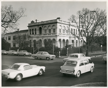
Photograph - Photograph, black and white, 15 05 1967
The Royal District Nursing Service (RDNS) Sister is leaving Headquarters, 452 St. Kilda Road, Melbourne, to administer nursing care to patients in their own homes. The Sisters nursed patients referred by Hospitals and General Practitioners giving treatments, such as injections, wound care and doing other procedures, as well as assisting them with general care when required. The Sister is driving an Australian built Holden car of the 1960s which, along with the other parked Holden cars are part of the RDNS fleet of vehicles. From its inception in 1885 the Trained nurses (Nurses) of the then named Melbourne District Nursing Society (MDNS), later named Royal District Nursing Service (RDNS) gave high quality nursing care to patients in their own homes. They nursed patients referred by Hospitals and General Practitioners giving treatments, such as injections, wound care and doing other procedures, as well as assisting them with general care when required. From the early days the Nurses taught the importance of good hygiene, cleanliness, good nutrition in the prevention and curing of disease and in maintaining good health, as well as giving advice and support to the patient and their carers. The Sisters liaised with the patient’s Doctor. District has had various modes of transport over the last 130 years. At first the Nurses walked the streets and lane ways amid the slums of central Melbourne. As the Society expanded bicycles, public transport, District cars, the use of a Motor Auxiliary, nurses own cars, and even a motorcycle were used, and all these forms were intermingled until RDNS had its own fleet of vehicles. By 2009 there were 598 cars in the fleet and the nurses travelled 9 million 200,000 kilometres – this is equivalent to 12 trips to the moon and back. The Royal District Nursing Service (RDNS) building at 452 St. Kilda Road, Melbourne was originally called 'Airlie', the childhood home of Stanley Melbourne Bruce, the Prime Minister of Australia 1923-1929. RDNS, then named Melbourne District Nursing Service (MDNS) moved into this building as their Nurses Home and Headquarters in 1953. MDNS was given Royal patronage in 1966 and continued to occupy the building until 1996. 452 St. Kilda Road, Melbourne is listed on the Victorian Heritage Register. In the foreground of this black and white photograph are three cars on St. Kilda Road passing Arthur Street on their left. In the centre is a Royal District Nursing Service, (RDNS), Sister sitting at the driving wheel of her RDNS grey Holden car in Arthur Street, at the corner of St. Kilda Road. Behind the car are two round poles inset in the nature strip near the kerb; the pole on the right holds the street signs 'Arthur St' which points to the left of the photograph, and 'St Kilda Rd' points towards the number '452' attached to a square concrete column and metal spiked fence running down the right of the photograph behind the nature strip. In the background of the photograph is the corner view showing two sides, part in Arthur Street and part in St. Kilda Road, of RDNS Headquarters which is a large white two storey Italian style building, which has arched Arcadia on the ground floor, and an arched Arcade on the second floor; a flat roof with two chimneys is seen. A garden with trees can be seen running in front of both sides of the building and behind the cast iron spiked fence. In Arthur Street, to the left of the large building is a two storey white building with a tiled roof. It has a white solid fence in front of it Parked at the kerb in front of this building, and the section of RDNS large white building in Arthur Street, are three other RDNS grey Holden cars. Parts of a large trees are seen on the left and right of the photograph.Photographers stamp. Quote GE 46rdns, royal district nursing service, rdns transport, rdns headquarters -
 Mont De Lancey
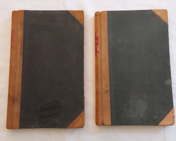
Book, Boxmoor, 1.Minute Book of the Berry Growers Section Victorian Fruit Growers Central Association. 2.Minute Book of the Berry Growers Association of Victoria, 1921 and 1929
These blank books were used by 1. Minute Book of the Berry Growers Section Victorian Fruit Growers Central Association. 2. Minute Book of the United Berry Growers Association of Victoria. Minutes of the first meeting of book 1. were taken 1st July 1921 in Lilydale and the last minutes were on 14.8.1929. Minute Book of the United Berry Growers Association of Victoria. Minutes of the first meeting of book 1. were taken 1st July 1921 in Lilydale and the last minutes were on 14.8.1929.Two large green fabric covered Minute Books with tan leather tape on the spine and two tan leather triangles on the corners of each of the front and back covers. Both books at the top of the spine have a red label with gold lettering Minute Book 1. has brown marbled end papers with blue tape along the spine for added strength inside both covers. Book 2. has burgundy marbled end papers with green tape along the spine for added strength inside both covers. Both books have coloured marbled edges to the pages. These blank books were used by 1. Minute Book of the Berry Growers Section Victorian Fruit Growers Central Association. 2. Minute Book of the United Berry Growers Association of Victoria. Minutes of the first meeting of Book 1. were taken 1st July 1921 in Lilydale and the last minutes were on 14.8.1929. The book is filled with Minutes of meetings. 2. Minute Book of the United Berry Growers Association of Victoria. Minutes of the first meeting of Book 2. were taken on Wed August 14th at 8pm 1929 in the Silvan Hall and the last minutes were on 26.7. 1945. The book is filled with Minutes of meetings. 170 out of 190 pages used. At the back is a handwritten note on faded and foxed lined paper for the 25th Report for the Association which did not have a formal page entry between the 24th and 26th and final entry. The details are noted in the photograph.non-fictionThese blank books were used by 1. Minute Book of the Berry Growers Section Victorian Fruit Growers Central Association. 2. Minute Book of the United Berry Growers Association of Victoria. Minutes of the first meeting of book 1. were taken 1st July 1921 in Lilydale and the last minutes were on 14.8.1929. Minute Book of the United Berry Growers Association of Victoria. Minutes of the first meeting of book 1. were taken 1st July 1921 in Lilydale and the last minutes were on 14.8.1929. meetings, reports, proceedings, minutes of meetings -
 Melbourne Tram Museum
Ephemera - Timetable, Melbourne & Metropolitan Tramways Board (MMTB), "Running Timetable and Locations of Recording Clocks", Jun. 1973
Set of photocopies of timetable information titled "Running Timetable and Locations of Recording Clocks" for various tram and bus routes - dated June 1973, signed R. C. Drummond Traffic Manager. Gives running times for sections during various parts of the day, early am, am peak, mid period, pm peak, weekdays, Saturdays and Sundays, and evening and the location of Bundy Clocks. Photocopied or retyped by donor 2016. 1442.1 - two sheets copied onto A4 paper and scanned to a pdf file. East Brighton - City via Swanston Carnegie - City East Malvern - City East Brighton - City - Dudley St Glen Iris -City Malvern Burke Road - City Camberwell - City via William St Camberwell - City via Swanston St Burwood - Spencer St Toorak - City Weekdays North Balwyn - City Wattle Park - Princes Bridge East Preston - City West Preston - St Kilda Beach Essendon Aerodrome - City West Maribyrnong Moreland - St Kilda Beach West Coburg - Domain Road North Coburg - City East Coburg - South Melbourne Beach. On A5 sheets - one large scan Carnegie - City - June 1973 Bulleen to Garden City - 18 June 1972 Bulleen to Garden City - Nov. 1963 East Brighton - City - Dudley St - Nov. 1968 East Brighton - City - via Swanston St - June 1973.trams, tramways, timetables, schedules, bundy clock, mmtb -
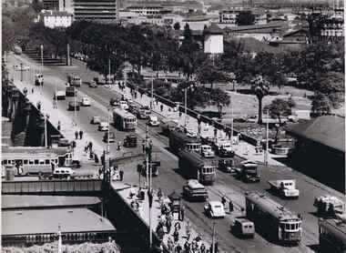 Melbourne Tram Museum
Photograph - Black & White Photograph/s, Australian Govt. Department of Information, late 1940's
Black and white photograph taken from St Pauls Cathedral Melbourne, looking south over Princes Bridge, early 1950's. Has nine trams in the view, mainly W2's, but one W3 and many motor vehicles, trucks etc. Shows the gardens in the now Southbank area, the junction just past the bridge of South Melbourne tram line, Wirth Bros Circus and other buildings, Prince Henry's Hospital. In particular is an Olympic pool direction sign hanging below the Batman Ave tram sign. This would have been the pool in Batman Ave, nearer to Flinders St, within the Flinders St yard complex, not the 1956 pool. Directly below is a female pedestrian dress in the classic 1950's "Dior" look. Over the bridge on the west side is "The Trocadero" formerly The Green Mill Dance Hall opened on 07/09/1926. West of that again is "Olympia" run by Wirth's . In the distance is Prince Henry's Hospital, the tall section was built in 1942, since demolished. Rod Atkins noted that the Olympia burnt down in the early fifties about the same the Trocadia closed, so pre 1953. Note the centre pole is still place at the Sturt Street intersection. In Batman Ave we have two W2's 401 and earlier one. In St Kilda Road we have four W2's in foreground in then W3 - No. 667 then a W4 then a SW6 in the distance. Outbound on route 4D is 578, behind it is 340 on route 5. A safety zone is between 578 and 340.Stamped on rear "Australian Official Photograph / Department of Information" and the number "L3121" in pencil.trams, tramways, swanston st, princes bridge, melbourne, south melbourne, tram 401, tram 667, tram 578 -
 Ballarat Tramway Museum
Magazine, K. V. Newmann and MMTB Public Relations Officer, "MMTB News", 1965
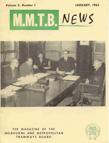
Eight issues of "MMTB News" - The Magazine of the Melbourne and Metropolitan Tramways Board. Two copies of each issue. Second copy added 31/8/2004. All issues printed with an off-white gloss paper cover with the rest of the magazine white glass paper. 2719.1 - Vol. 2, No. 1 - 16 pages, January 1965, with a photo of the Board meeting in the Board room of the MMTB, notes or articles on traffic congestion, a short history of public street transport in Melbourne, TMSV tour of 7/2/1965 with PCC 980, and" Some Views on Public Transport". 2719.2 - Vol. 2, No. 2 - 16 pages, February 1965, with a photo of Dusseldorf 3 section tramcar on the front cover, notes on the costs of concessions, press visit to the Carlton Power control supervisory centre, "Melbourne - 1985", Mark VI buses, tool safety, "Staggered Working Hours", hydro-foil on Sydney Harbour, "Traffic Congestion". 2719.3 - Vol. 2, No. 3 - 12 pages, March - April 1965, with a photo of W7 1012 and bus 751 on the front cover, notes or articles on "New Trams for Melbourne", retirement of D.H. Eakin, "Traffic Congestion", "Tramway buses at the Gippsland Fires", The Australian Good Neighbour movement. 2719.4 - Vol. 2, No. 4 - 16 pages, May - June 1965, with a photo of L 101 at West Maribyrnong terminus during an Association of Railway Enthusiasts tour (photo Robert Wilson), notes or articles; "A Motorist Speaks Up for Trams", "Tramways Hospital a Major Benefit", parking in the central city, tramway ambulance, "Radio Control is Human Nerve Centre", staff shortages, retirement of Mr. Stan Bowen, the ARE Tram Tour, and Port Melbourne Tramways Social Angling Club. 2719.5 - Vol. 2, No. 5 - 16 pages, July 1965, with a photo of the Doncaster Bus depot on the front cover, articles or notes; Freeways, Public Transport, Decimal conversion, Doncaster Bus depot, Melbourne in twenty years, Engineering Department - Bus branch, visit of Mr Ken Hall and Frank Kirby overseas to study new trams. 2719.6 - Vol. 2, No. 6 - 20 pages, August September 1965 with a photo of W6 921 being lowered at Preston Depot, with notes or articles; an abridged version of an address by R. J. Risson to the Constitutional Club in Melbourne, lost items on trams, Bus Engineering, and social or sporting club news. 2719.7 - Vol. 2, No. 7 - 16 pages, October - November 1965 with a photo of PCC 980 on the front cover, notes or articles on; free travel for USA City shoppers, safety, Stores Department printing section, Ballarat's Tramways Diamond Jubilee - TMSV tour to Ballarat on 15/8/1965 including two photos, PCC 980, Christmas functions, retirement of Arthur Wisdom and Bill Wallis. (Reference photos Reg. Item - 1877). See btm2819i9 for image of the article re the TMSV Tour to Ballarat. 2719.8 - Vol. 2, No. 8 - 16 pages, December 1965 with a photo of cable car set No. 1 on the front cover with notes or articles; Children's art show, "Quest for New Tram", "The Development of Melbourne's Trams" and sporting or social club news. Has a Christmas message from Chairman, Mr. Risson with photograph.Each issue has stamped on the front cover or inside "The Australian Railway Historical Society (S.A. Branch).trams, tramways, mmtb, carlton control, buses, pcc 980, ballarat, new trams, are, tmsv -
 Melbourne Tram Museum
Magazine, K. V. Newmann, MMTB Public Relations Officer, "MMTB News", 1965
Eight issues of "MMTB News" - The Magazine of the Melbourne and Metropolitan Tramways Board. Two copies of each issue. All issues printed with an off-white gloss paper cover with the rest of the magazine white glass paper. 1722.1 - Vol. 2, No. 1 - 16 pages, January 1965, with a photo of the Board meeting in the Board room of the MMTB, notes or articles on traffic congestion, a short history of public street transport in Melbourne, TMSV tour of 7/2/1965 with PCC 980, and" Some Views on Public Transport". 1722.2 - Vol. 2, No. 2 - 16 pages, February 1965, with a photo of Dusseldorf 3 section tramcar on the front cover, notes on the costs of concessions, press visit to the Carlton Power control supervisory centre, "Melbourne - 1985", Mark VI buses, tool safety, "Staggered Working Hours", hydro-foil on Sydney Harbour, "Traffic Congestion". 1722.3 - Vol. 2, No. 3 - 12 pages, March - April 1965, with a photo of W7 1012 and bus 751 on the front cover, notes or articles on "New Trams for Melbourne", retirement of D.H. Eakin, "Traffic Congestion", "Tramway buses at the Gippsland Fires", The Australian Good Neighbour movement. 1722.4 - Vol. 2, No. 4 - 16 pages, May - June 1965, with a photo of L 101 at West Maribyrnong terminus during an Association of Railway Enthusiasts tour (photo Robert Wilson), notes or articles; "A Motorist Speaks Up for Trams", "Tramways Hospital a Major Benefit", parking in the central city, tramway ambulance, "Radio Control is Human Nerve Centre", staff shortages, retirement of Mr. Stan Bowen, the ARE Tram Tour, and Port Melbourne Tramways Social Angling Club. 1722.5 - Vol. 2, No. 5 - 16 pages, July 1965, with a photo of the Doncaster Bus depot on the front cover, articles or notes; Freeways, Public Transport, Decimal conversion, Doncaster Bus depot, Melbourne in twenty years, Engineering Department - Bus branch, visit of Mr Ken Hall and Frank Kirby overseas to study new trams. 1722.6 - Vol. 2, No. 6 - 20 pages, August September 1965 with a photo of W6 921 being lowered at Preston Depot, with notes or articles; an abridged version of an address by R. J. Risson to the Constitutional Club in Melbourne, lost items on trams, Bus Engineering, and social or sporting club news. 1722.7 - Vol. 2, No. 7 - 16 pages, October - November 1965 with a photo of PCC 980 on the front cover, notes or articles on; free travel for USA City shoppers, safety, Stores Department printing section, Ballarat's Tramways Diamond Jubilee - TMSV tour to Ballarat on 15/8/1965 including two photos, PCC 980, Christmas functions, retirement of Arthur Wisdom and Bill Wallis. (Reference photos Reg. Item - 1877). See btm2819i9 for image of the article re the TMSV Tour to Ballarat. 1722.8 - Vol. 2, No. 8 - 16 pages, December 1965 with a photo of cable car set No. 1 on the front cover with notes or articles; Children's art show, "Quest for New Tram", "The Development of Melbourne's Trams" and sporting or social club news. Has a Christmas message from Chairman, Mr. Risson with photograph.trams, tramways, mmtb, carlton control, buses, pcc 980, ballarat, new trams, are, tmsv -
 Bendigo Military Museum
Mixed media - SCRAPBOOK BENDIGO RSL, C. 1967 - 1972
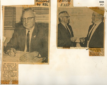
This is the 2nd set of 6 pages from Scrap book Cat No 8225. Page 7a. Photo and article re Sam Ryan receiving a Life Membership of the RSL. Refer Cat No 8225. Page 7b. Photo and Article of Sam Ryan President Bendigo RSL receiving a cheque from Mr W.P. Casey Chairman of Directors of the Bendigo Easter Fair. Page 8. Phot and article 1969 re the planting of an Aleppo Pine tree from the original on Gallipoli. On the Left is Jack Plant President Bendigo RSL, the other two persons unknown as section of the text is missing. Page 9a. Anzac Appeal 1969, Mr John Ogden pins an Anzac token on the coat of Phillip Rice. Page 9b. From the "Mufti" RSL Magazine showing Delegates to the RSL State Conference 1969. Three of the six are known, W.B. Nicholls, D.J. Osborn, J. Hipworth State Councillor. Page 9c & d. Jack PLant in both photos on the left, other man unknown as well as place. Page 10. From the bendigo Advertiser relating to the Bendigo RSL Annual Dinner held on Saturday 10th 1971. From the left is G. Garth President Kangaroo Flat RSL, Lt Col W. Howarth Commanding Officer AHQ Survey Regiment, T. Shaw State Executive of the RSL, J Plant President Bendigo RSL, T Stephens Deputy Commissioner Repatriation Department and Cr N.J. Oliver the Mayor of Bendigo. Page 11a. Photo from a Bendigo RSL Annual Dinner year unknown, 2nd from the left is Bruce Ruxton State President of the Victorian RSL, 2nd from the right is possibly W.B. Nicholls, others onknown. Page 11b. This is a photo of RSL Annual Dinner 1971, same as per Page 10 for details. Page 12. Photograph of Bendigo RSL Annual Dinner year unknown. 2nd from the left is Jack Plant, the man to the left of man standing is possibly W. Howarth CO Survey Regiment.Six articles and Spiroflex sketch book. Page 7. Photo and article re the award of a Life Membership. Page 8. Photo and article re planting a Lone Pine tree. Page 9. Two articles and two photos re Appeals and State Conference. Page 10. Photo and article re RSL Annual Dinner. Page 11. Two photos re RSL Annual Dinners. Page 12. One photo re RSL Annual Dinner. Page 8 hand written, "1969". Page 9, hand written names as per "Context"brsl, smirsl, scrapbook -
 Queenscliffe Maritime Museum
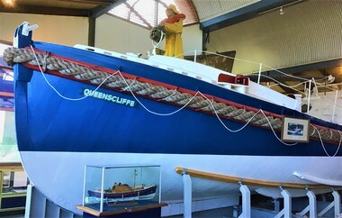
Vehicle - Lifeboat, A McFarlane and Sons, Lifeboat Queenscliffe, 1926
QUEENSCLIFFE was built in 1926 to a Royal National Lifeboat Institution (RNLI) design called the Watson Class. The double-diagonal planked vessel was built by A McFarlane and Sons in Port Adelaide SA, commissioned on the 6th of March 1926, and then officially named and launched on the 9th of April 1926. The original Wayburn petrol engine was replaced with a Gardner diesel. This gave QUEENSCLIFFE a top speed of 7.5 knots with a range of 350 miles. The equipment carried aboard included a VHF Radio Telephone, HF radio transceiver, visual signals, life rafts, hand rocket gun, flare gun, generator, search light and first aid supplies. In the tradition of many shore based lifeboats, QUEENSCLIFFE had its own shed and slipway and was always ready for launching when required to go to sea in response to an emergency call. Its area of operation included 'the Rip' at Port Phillip Heads and the Bass Strait seas immediately offshore. She was taken out of service in 1976 by the Marine Board of Victoria and subsequently offered to the Borough of Queenscliffe for care and display. The Lifeboat is listed on the Australian Register of Historic Vessels (ARHV). During her 50 years of service the Queenscliffe attended many calls for assistance both inside and outside the Heads. Some of the vessels and calls for help the lifeboat attended were: 1960 - Army Commandos lost in the Rip 1967 - The search for the late Prime Minister Harold Holt 1974 - The last attendance to a vessel was to the Brisbane Trader which was on fire The shed which housed the lifeboat is located on the Queenscliff 'New' or 'Steamer' Pier (built in 1884). This shed includes the internal section of the slipway used to launch and retrieve the lifeboat. The external slipway and some other structures associated with the lifeboat shed have been removed. Originally fitted with two masts, the stern mast being removed in the 1960's. A retractable centre plate was used when under sail. Delivered with an 80 hp Wayburn petrol motor which was later replaced by a 72 hp Gardiner diesel. Top speed of 7.5 knots and a range of 350 miles.QUEENSCLIFFE is a wooden lifeboat built in 1926 in South Australia. It has a long association with the Victorian port of Queenscliff. It was manned voluntarily by their local fishermen and is therefore closely attached to families of the Queenscliff community. It is a rare surviving example of the coastal shore-based lifeboats that were based around the Australian coastline.The lifeboat 'Queenscliffe' a Watson Class LifeboatQueenscliffelifeboat, rescue, watson class boat -
 Vision Australia
Administrative record - Text, The Association for the Blind, Blind Members' Council meeting minutes 5/11/1982 to 24/2/1986, 1982-1986
These meetings were held at the Kooyong office and the minutes include Present, Chair, Apologies, Minutes, Matter arising from minutes, Correspondence, Life governors, Election of members, Nominations, Reports from Regional Blind Members groups, White Cane Day October 15th promoted. Some highlights include: 3/12/1982 the film, 'A world that is dark', which was made by AFB for television release is now available on video. 31/8/1984 the Blind members' brochure includes sections titled 'Yesterday, Today and Tomorrow' which outlines the history, present position and the aims for the future of the AFB, 'Information about Blind Members' and Blind Members' Council', List of AFB homes and centres' and 'An invitation from Bryan Sitlington to be a Blind Member accompanied by an application form. It will be available to all visually impaired people, their family and friends, AFB staff and suitable for distribution at doctor's surgeries. 14/12/1984 it was reported 29 new Blind members were elected at the September meeting and the 1,000th member was among them. 8/6/1984 Mr John Blanch reported that the General Committee had approved, although rather reluctantly, Mr John Wilson's resignation and had appoint Mr John Cook as his successor. 13/9/1985 Mr John Blanch reported that following Mr Pat Lightfoot's resignation he had contacted Mr John Wicking to offer him the position of sighted representative on Blind Members' Council. John Wicking had been approached for role on the BMC however he was unable to attend Fridays. It was moved to move the meetings to the last Monday of the Month, after approaching John Wicking again. Council members agreed that if John Wicking took the position it would be good as would have been held by Pat Lightfoot and John Wicking, both past Presidents of AFB. Mrs Margaret Canavan and Mr Alan Cooper had been selected to attend a garden party at Government House with Her Majesty the Queen and His Royal Highness the Duke of Edinburg on Thursday March 6. Minute book for Blind Members Councilassociation for the blind, blind members council -
 Wodonga & District Historical Society Inc
Plaque - Plaque 1981 Rotary International Pacific Region Conference, Betty L. Barberis
This item was donated to Wodonga Historical Society by the artist, Betty L. Barberis. Betty Barberis nee Barton was one of 12 children born to Roderick Barton and Myrtle Ann Hore of Gundowring in the Kiewa Valley. She was born in 1927 and attended Upper Gundowring Primary School. Betty was encouraged to enter a project for the "Young Farmers" by illustrating a book. She won first prize for Victoria and the book was exhibited at the Royal Melbourne Show. This resulted in Betty attaining a Manual Art Teacher's Studentship which she completed at Wangaratta Technical School. Here she learned many new skills ranging from garment design to ceramics. She also attended Melbourne Teachers College. Betty created many decorative banners, the first being for the Australian section of the World Scout Jamboree in 1948. Over her long career she was to create many other banners and commissioned work for significant organisations and institutions . Betty’s great body of work included landscapes, millinery, ceramics, and a bronze sculpture of her husband Vern Barberis who was a fellow schoolteacher and represented Australia as a weightlifter, winning a bronze medal at the Helsinki Olympics in 1952. She also illustrated several books and had exhibitions in many galleries including in Albury. Betty passed away at The Grange, Wodonga on 26 November 2013. The 1981 Rotary International Pacific Region Conference was held in the Royal Exhibition Building, Melbourne, between 26 and 29 November 1981. More than 5,000 Rotarians from around the Pacific attended the conference in Melbourne to discuss 'The Future of the Pacific Region'. Speakers included the Honourable Malcolm Fraser, Rotary International President Stan McCaffrey, President Elect Horoji Mukasa, Ranald McDonald, representing the media, Sir Ian McLennan, representing industry, Japanese former Ambassador Nobuhiko Ushiba and Philippines Deputy Consul General Mrs Minerva Falcon, both representing diplomatic services, as well as other Rotarians. A limited number of plaques were produced from quality imported porcelain.This item represents a major event held in Melbourne for Rotary International and is also the work of a prominent artist from the Wodonga district.2 ceramic plaques designed by Betty Barberis for the emblem of the 198T Rotary International Pacific Region Conference held in Melbourne in 1981. The plaque bears the Rotary emblem, slogan and other text as well as an image of a kangaroo and lyre bird.In top banner: "SERVICE - ABOVE - SELF" In central circle: "ROTARY INTERNATIONAL" around 1981 In lower banners: "PACIFIC REGIONAL CONFERENCE / MELBOURNE AUSTRALIA".betty barberis, rotary international, 1981 rotary international pacific region conference -
 Wodonga & District Historical Society Inc
Memorabilia - Woodland Grove Souvenir dish made by RKG under licence for Royal Sydney China, Czechoslovakia, c. 1920, RKG, c. 1921 - 1938
A wide range of souvenirs have been produced to commemorate Wodonga and its landmarks over time. These items document key changes in Wodonga and its heritage. The producers mark on the plate was used by the company RKG Czechoslovakia between 1921 and 1938 This plate depicts three key landmarks in Wodonga. THE SOLDIERS' MEMORIAL in Wodonga was unveiled on Tuesday 18th November 1924. It was designed by Messrs. Hosken & Co., of Hawthorn, Victoria. The monument is all of Australian workmanship. The pedestal is made of Harcourt granite, 9ft x 9ft at the base, and rising in seven courses to a height of 10ft 2in. The emblems (rising sun and wreath) are of bronze, and the lettering of the inscription and names of fallen soldiers are in raised lead letters. Originally the Memorial was completed with a full life size, 6ft in height, sculpture of an Australian soldier in Sicilian marble. The memorial bore the inscriptions: ERECTED BY THE RESIDENTS OF WODONGA AND DISTRICT IN MEMORY of the Men of this Town and District who fell in the Great War, 1914-1919, Also in grateful recognition of the men who served and returned. “Lest We Forget.” In 1982, due to frequent vandalism and high cost of materials to repair, the soldier statue was removed and later installed at the RSL Rooms. THE WATER TOWER is a major landmark of High Street, Wodonga. It began operation from 1924 until it ceased operation in 1959. It stood unused for a decade until the lower section was modified and put to use as “ The Tower’s Cobbler’s Inn” in 1962. In 1972 Wodonga City Council proposed to demolish the Tower. Their suggestion received an unfavorable response from the city’s citizens, so the Tower still stands today. THE BAND ROTUNDA was officially opened on Sunday 5th September 1920 at the naming of the triangular reserve at the corner of High and Hovell Streets as Woodland Grove. The Wodonga Band gave a public performance on this occasion. The tri-coloured ribbon, which stretched across the entrance to the Rotunda was cut by Mrs R.H Murphy, daughter of Mr. John Woodland, secretary of the Wodonga Shire Council for 35 years, after whom the area was named. The rotunda has since been moved to Martin Park, Wodonga. Small china pieces carrying scenic views of holiday destinations were a popular kind of souvenir during much of the 20th century. These items have local and social significance as they reflect the landmarks or local features valued by the community over time. An apricot irregular shaped dish made from lustre ware with a drawing of the Wodonga Soldiers Memorial, Water Tower and Rotunda. The manufacturer's mark is imprinted on the base. Text under the image says 'THE SOLDIERS' MEMORIAL. WODONGA. VICManufacturer's trademark printed on base, in orange paint, in a circular formation 'ROYAL SYDNEY CHINA / MADE IN / CZECHOSLOVAKIA', within circular formation '(crown) / RK / G' ('RK / G' within circle with handles).porcelain, wodonga, royal sydney china, soldier memorial, wodonga souvenirs -
 Eltham District Historical Society Inc
Document, Appointment of new Trustee for Eltham Public Hall, Lot 20 Henry Street, Eltham, 6 Aug 1925
Indenture made 6 August 1925 between Ernest James Andrew, News Agent, Cyril Robert Nicholls, Grocer, John Michael Ryan, Builder, Ellen Matilda Andrew, Married Woman, Alice Maude Bourke, Spinster, Mary Ellen Birchall, Married Woman, Adeline Gertrude Phillips, Married Woman, Minnie Maria Isherwood, Married Woman, Florence Garner, Spinster, Ethel Boake, Married Woman, Edith Marion Bowman, Married Woman, Clarice Armstrong, Spinster, Annie Ryan, Married Woman, William Pasco, Gentleman, Thomas Bowman, Printer, Arthur Copeland Christopherson, Grocer, Thomas Nunan Jewell, Carpenter all of Eltham (the Committee of The Eltham Hall) and William James Capewell, Butcher and Ernest James Andrew both of Eltham and Trustees for The Eltham Hall and George Birchall, Hatter of Eltham to be appointed a Trustee in lieu of George Harrison who requested to be discharged as a Trustee. Originally purchased in 1856 from Thomas Roberts, Yeoman of Little Eltham, for £10 for use by the Wesleyan Chapel, represented by indentured Trustees, Rev. Barnabas Shaw Walker, Minister of the Pentridge Circuit, Francis Thomas, Farmer of Keelbundora, William Harriman, Blacksmith of Nillumbik, Nicholas Rodda, Farmer of Nillumbik, Aaron Grimshaw, Farmer of Greensborough, Joseph Cooper, Gardener of Keelbundora, Peter Dredge, Scholmaster of Jika Jika and Samuel Jeffrey, Farmer of Jika Jika. Lot 20 of Subdivision of Portion 13, Section 4 of the Parish of Nillumbik in the County of Evelyn was located on the southern side of Henry street in Little Eltham North, where the current Our Lady Help of Christians Catholic Church is situated. It became the location of the Eltham Rechabite Hall. In 1893 a new hall was built and further enlarged in 1919. At the commencement of 1922, the property was purchased from the Independent Order of Rechabites with publicly subscribed funds and a new hall built at a cost of £750 and improved road access constructed to reduce the grade, running from Dudley Street to Henry Street. This hall was eventually replaced with the new Shire Offices and Hall built on the corner of Arthur Street and Main Road, which was opened in 1941. Traces the earliest history of the Eltham Public Hall in Henry Street and the various names, occupations and abodes of the Trustees associated with the propertyadeline gertrude phillips, alice maude bourke, annie ryan, arthur copeland christopherson, clarice armstrong, cyril robert nicholls, edith marion bowman, ellen matilda andrew, eltham public hall, eltham rechabite hall, eltham wesleyan chapel, ernest james andrew, ethel boake, florence garner, george birchall, george harrison, grocer, henry street, john michael ryan, mary ellen birchall, minnie maria isherwood, thomas bowman, thomas nunan jewell, trustee, william james capewell, william pasco -
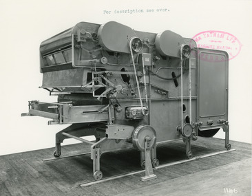 National Wool Museum
Photograph - Product Photograph, Automatic Feeding Machine
These are sales photographs for William Tatham Ltd. of Rochdale. These photographs are taken in the fitting shop at William Tatham Ltd. where final assembly would have taken place. The Automatic Feeding Machine automatically dispenses wool to a carding machine, so that an even, constant supply is received. This eliminated the manual labour previously needed for the initial weighing and feeding of wool. The photographed machine was made by William Tatham Ltd, a textile engineering company based in Rochdale, UK. Established in 1866, Tatham developed innovative textile machinery and sent their products to Australia and other countries around the world.Two black and white photos of an Automatic Feeding Machine in a landscape format. The first photo is of the front of the machine, the second is of the rear.8037.1 - Front - top margin: For description see over. Front mide right edge - Wm. TATHAM Ltd. ROCHDALE. Machine Maker Front bottom right corner - 1146 Rear - 78” wide Automatic Feeding Machine having Dual Hoppers in which the first and large section feeds the second Hopper so as to maintain a constant level of material in the latter. The driving of both spiked lattices is by electro-magnetic clutches, the one in the first Hopper being actuated by a sensitive feeler motion in the second, the second spiked lattice however, being controlled, of course, from the Scale Pan. Through a mercury switch. The scale is of our latest super-sensitive pattern mounted diagonally across the Feed. Only the opening doors are used in the actual weighting and the trap doors placed over the scale which close immediately the correct weight is deposited, operate through a solenoid. The machine incorporates many other features and is arranged to divide for facility in cleaning. 8037.2 - Front mide right edge - Wm. TATHAM Ltd. ROCHDALE. Machine Maker Front bottom right corner - 1147 Rear - Showing opposite side of Dual Automatic Feed illustrated in photo 1146textile machinery, automatic feeding machine, tatham, feeding machine -
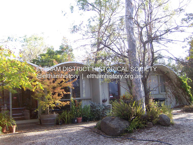 Eltham District Historical Society Inc
Photograph - Digital Photograph, Marguerite Marshall, Rice House, 69 Ryans Road, Eltham, 27 March 2007
Built in 1953, the Rice House was leading Melbourne architect Kevin Borland's first commssion and was one of two houses of its kind. The design of the shell-like structure was inspired by the Arch of Ctesiphon, built in the second century south of Baghdad. Cement with a waterproofing agent was applied in layers to a form of regularly spaced timber arches covered in hessian. This ctesiphon system was developed in the United Kingdom by engineer J.H. de Waller in 1947. Commissioned in 1951 by Harrie and Lorna Rice, after Harrie, then an art student, met Borland at The Age Small Homes Service. Borland suggested they buy land in Eltham because at that time it was the only council in Melbourne that would grant a permit for such an innovative house. Covered under Victorian Heritage. Published: Nillumbik Now and Then / Marguerite Marshall 2008; photographs Alan King with Marguerite Marshall.; p157 Inspired by an ancient arch in Iraq, a house stands on top of a hill in a private position, off Ryans Road, Eltham. One of only two houses of its kind, it was leading Melbourne architect Kevin Borland’s first commissioned house, which he built in 1953. The shell-like structure, partially screened by giant trees and cacti, was inspired by the Arch of Ctesiphon south of Baghdad, built in the second century.1 Cement with a waterproofing agent was applied in layers to a form of regularly spaced timber arches tightly covered by hessian. This ctesiphon system was developed in the United Kingdom by engineer J H de Waller in 1947. This house was the first of three such structures built in Victoria, of which only one other remains, although substantially altered.2 It is the Wood House and supermarket, at the corner of Cleveland Road and High Street Road, Ashwood, designed by Robin Boyd in 1952. The Rice House demonstrates Kevin Borland’s innovative and experimental work. It is an outstanding example of the post-war period of experimentation in domestic architecture in Melbourne – by Robin Boyd, Kevin Borland and others – for The Age Small Homes Service from 1947 to 1953. This was partly an expression of late-Modernism and also necessitated by the post-war shortage of building materials. In Eltham, the post-war shortage of building materials largely resulted in mud-brick houses. Examples of Borland’s public work include contributions to the Olympic Swimming Pool in Melbourne and the Preshil Junior School in Kew. After more than 50 years of living in the house, Harrie and Lorna Rice still love it. Facing north-east with large windows overlooking the garden and two courtyards, it is well lit and benefits from a through breeze. The couple commissioned the extraordinary house after Harrie, then an art student, met Borland in 1951 at The Age Small Homes Service. Harrie was so impressed by the recently graduated Borland’s enthusiasm, that he asked him to design them an interesting house for a low budget.3 The unusual design presented several hurdles for the young couple before they could construct it. Borland suggested that they buy land in Eltham, because at that time it had the only council in Melbourne that would allow such an innovative house. Another hurdle was to gain finance for this remarkable house. The State Savings Bank Manager refused finance on the grounds that it was ‘unliveable’ and a ‘disgrace’. Fortunately, through a family connection, the couple borrowed money from the National Bank. But they discovered years later, that the bank’s evaluation stated the two ‘concrete sheds’ were of no value!4 The house built in off-white concrete, consists of two sections. The main house has four arches supported by brick and concrete walls that create a series of inter-connected rooms. Inside, the ceiling follows the roofline. Originally this section was only ten square metres, because of building restrictions at the time. But in 1973 Borland added two rooms and a carport. The second structure of two arches was originally a garage and a studio for art teacher Harrie Rice. To accommodate the growing family, in the mid 1950s, Borland converted the second structure into two children’s bedrooms, a kitchenette, a bathroom and a living room. The two structures were originally linked by a covered way of suspended draped-concrete, but this collapsed in the 1980s. The design has several maintenance problems. Cracks developed where two halves of the shells were joined. Then the material sprayed over the cracks became brittle, causing leaks. Fortunately Harrie found another material he could use. The valleys between the arches collect water, requiring annual painting with a waterproof material to prevent leaking. Lorna framed the house with native and exotic plants, which provide privacy and as a bonus, the garden attracted the rare Eltham Copper Butterfly.This collection of almost 130 photos about places and people within the Shire of Nillumbik, an urban and rural municipality in Melbourne's north, contributes to an understanding of the history of the Shire. Published in 2008 immediately prior to the Black Saturday bushfires of February 7, 2009, it documents sites that were impacted, and in some cases destroyed by the fires. It includes photographs taken especially for the publication, creating a unique time capsule representing the Shire in the early 21st century. It remains the most recent comprehenesive publication devoted to the Shire's history connecting local residents to the past. nillumbik now and then (marshall-king) collection, eltham, rice house, ryans road -
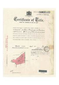 Ringwood and District Historical Society
Document, Certificate of Title - Alexander William Brown - part of Crown Section 20, Parish of Warrandyte, County of Evelyn - 16th April, 1948
A4 copies of Landata Victoria Historical Search documents - Vol 7141 Fol 1428080.Alexander William Brown of Grandview Grove (later Bemboka Road), Ringwood is now the proprietor of an Estate in Fee-simple subject to the Encumbrances notified hereunder ... 2 acres 3 roods 24 and one-half perches or thereabouts, being Lots 33 and 34 Kardinia Crescent, on Plan of Subdivision no.12040. Transfers include Alexander William Brown died 25th June, 1957, Probate granted 28th January, 1958, to Alfred Hart Brown of Dandenong, Estate Agent, and Harry Britten Elms of Cardinia, Gentleman, Oliver Burgess, Grandview Grove Ringwood, Florist - 14th May, 1964, Peter John Woodhead, Transport driver, and Shirley Margaret Woodhead, Married woman - 12th September, 1966. Inventory of Real Estate Assets (for Probate purposes 4/10/1957) detailed in Family Genealogy record for A.W. Brown includes: "Kardinia Crescent, Ringwood - Land containing 2 acres 3 roods 24-1/2 perches situate in Kardinia Crescent Ringwood being Lots 33 and 34 on Plan of Subdivision Number 12040 and being part of Crown Section 20 Parish of Warrandyte County of Evelyn and being the land described in Certificate of Title Volume 7141 Folio 080 valued by E. Miles at £350:0:0 -
 Glenelg Shire Council Cultural Collection
Photograph - Photograph - Portland Lifeboat, n.d
Built in 1858 at the Port and Harbour Master's yard in Williamstown Victoria, the Portland Lifeboat was overseen by Harbour Master Charles Ferguson. It is understood to have been constructed from the same moulds used to build the Port Fairy Lifeboat, designed by William White, in 1857. Both boats are similar to the lifeboats designed in England by James Peake and adopted by the Royal National Lifeboat Institution (RNLI) in the UK. The Portland Lifeboat's 9.14 m (30 ft) long hull is double diagonally planked in New Zealand kauri, and many of the planks run from gunwale to gunwale in one piece under the inner keel section. Eucalyptus and oregon were used elsewhere and the local blacksmith made the iron work. The fastenings are copper. There are two flotation or buoyancy tanks at either end, with prominent whaleback style decking. Under the thwarts is a deck with scuppers so that the craft is both buoyant and self draining whenever large waves are taken aboard in rough conditions. The lifeboat was oar-powered with a sailing rig. The original rig was a lug mainsail, but this was replaced with a lug and headsail rig taken from a fishing boat in 1903. The lifeboat was manned by volunteer crews, mostly local fishermen from Portland. They maintained this service until 1915 when the boat was replaced with a new motorised craft. The lifeboat's most outstanding service was to the steamer ADMELLA in 1859 when the ship grounded on a reef off Cape Banks in South Australia, 150 km to the west of Portland. Survivors clung to the rigging in heavy seas for over a week and 89 people lost their lives in the shipwreck. Taken to the scene by the steamer LADY BIRD, the Portland Lifeboat was unable to assist until eight days after the ADMELLA's grounding when the seas abated enough for the lifeboat to manoeuvre close to the ship and rescue the last 19 survivors. Since its retirement in 1915 the lifeboat has been a memorial to those who manned it and those it rescued. For a long period it was on display in the Portland Gardens, first in the open and then under a canopy. In 2008 it was on display inside the Portland Maritime Discovery Centre, still in original condition complete with the rig from 1915. It is one of the oldest vessels of its type in Australia, and the world.Portland LifeboatPhotograph showing the Portland Lifeboatphotography, portland lifeboat, admella -
 Flagstaff Hill Maritime Museum and Village
Sign - Shipwreck Museum sign, Flagstaff Hill Historic Park Planning Board, Shipwreck Museum, ca. 1975
This sign is painted on both sides. It was attached to the bluestone wall on the western wing of the Lighthouse Keeper's Quarters, the Assistant Keeper's Quarters, at Flagstaff Hill Maritime Museum and Village for almost 50 years. The Complex was opened to the public on December 11, 1975, and officially opened by Victorian Premier Sir Rupert Hamer on July 8th, 1977. The sign's reverse side reads "Loch Ard Peacock & Museum". The three rooms had displays behind glass showing various ships' fittings, cargo and personal belongings recovered from significant shipwrecks along the southwest coast of Victoria. There was also a display of information about the mysterious Mahogany Ship or Ancient Wreck. The shipwreck artefacts were recovered by local divers in the 1960s and early 1970s. Also on display was the famous Loch Ard Peacock, created in 1873, survived the shipwreck in 1878, was purchased by Flagstaff Hill in 1975 and announced as being on display in The Standard of September 15, 1975. In about 1984 the other side of the sign was painted "SHIPWRECK MUSEUM" and re-displayed on the building. The Loch Ard Peacock was by that time on display in the Entrance building; plans were underway on August 31st 1984 to build a Hall for its unique display. In February 2023 the sign was removed from the building, which was undergoing restoration and preparation for use as a new Temporary Exhibition space. The Loch Ard Peacock continued its journey around the Village; it was moved from the Entrance to the Village's newly completed Public Hal in 1986. It also spent a short time in the Stella Maris Tea Rooms. This was likely around 1998, when the Common School had moved from the Chartroom building to what had been the Public Hall. The Loch Ard Peacock was once again moved in around 2001, this time to be the central attraction and meeting place in the Great Circle Gallery, which opened on December 31st 2002. The sign continued to be displayed on the western wing of the Lighthouse Keeper's Quarters until February 2023. This wing has now been restored and re-fitted to become a facility for short-term exhibitions. A section of the original internal wall frame and wallpaper that couldn’t be kept in the building due to preservation issues have been saved and become sort of the Flagstaff Hill Collection. The sign has guided the visitors of Flagstaff Hill Maritime Museum and Village to the exhibits of artefacts from historic and significant shipwrecks. It has connected the current generations to the people and objects of the past, leading to a better understanding of our Colonial history.Sign, wooden, rectangular, with a hole through each short side. The front and reverse have different painted text. Cream paint for the background colour, green paint for the lettering, and the reverse has a white painted border. The front has an arrow painted on the right-hand side. The sign was used at Flagstaff Hill since its opening.Text on front "SHIPWRECK MUSEUM >" Text on back "LOCH ARD PEACOCK / & MUSEUM"flagstaff hill maritime museum and village, warrnambool, great ocean road, shipwreck coast, sign, building sign, shipwreck museum, loch ard peacock & museum, flagstaff hill history, assistant lighthouse keeper's cottage, assistand lighthouse keeper's quarters, public hall, common school