Showing 11430 items
matching map
-
 Federation University Historical Collection
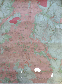
Map, Creswick, Clunes, Smeaton, Newstead, Yandoit and District, 1904, 06/1904
A coloured geological map with green and pink predominating. The shows Ascot, Creswick, Clunes, Franklinford, Miners Rest, Sandon, Smeaton, Tourello, Yandoitascot, creswick, clunes, franklinford, miners rest, sandon, smeaton, tourello, yandoit, mt moorookyle, powlett's hill, woodhouse's hill, smeaton hill, mcdonald's hill, green hill, spring hill, horse shoe hill, mt cameron, strangways, avoca forest, stanley hunter, j.w. gregory, d. mcleod, donald mcleod, daruel -
 Whitehorse Historical Society Inc.
Map, Shire of Blackburn and Mitcham, 10/10/1939 update
Map of Shire of Blackburn and Mitcham showing Departmental ball hydrants and departmental pillar ball hydrants.Map of Shire of Blackburn and Mitcham showing Departmental ball hydrants and departmental pillar ball hydrants. Scale 8 chains to 1 inch.Map of Shire of Blackburn and Mitcham showing Departmental ball hydrants and departmental pillar ball hydrants.shire of blackburn and mitcham, fire hydrants, blackburn, blackburn north, blackburn south, burwood east, forest hill, mitcham, nunawading, vermont, vermont south -
Whitehorse Historical Society Inc.
Map, Blackburn Lake - Elmore houses walk, 1/10/1991
Walking map, Ken Green. Copy 1 :Walking map, Ken Green. Copy 1 : Oct '91. See C-B 19 ND655 for copies marked 'November '91'.Walking map, Ken Green. Copy 1 : elmore houses, blackburn lake sanctuary, blackburn, the avenue, blackburn, laburnum street, blackburn, main street, blackburn, gardenia street, blackburn -
 Flagstaff Hill Maritime Museum and Village
Map - Survey Map, F.F. McGovern, Yangery - County of Villiers, 1884
A surveyor was employed to measure the land designated as Yangery, County of Villiers, in the Borough of Warrnambool. The area on the map is similar to the earlier Farnham Survey undertaken by William Rutledge in the 1850's. Warrnambool was a Borough between 1863-1883. Coutours, waterways, sea and other significant points are shown. The distances are accurately measured. This survey map was used for planning future land sales, recreation areas and roads. WILLIAM RUTLEDGE (1806-1876) William Rutledge surveyed the land known as Farnham in southwest Victoria in 1843. His tenants made him a profitable business from working the land there. In 1863 Rutledge moved from nearby Port Fairy to Farnham and became very successful in breeding sheep, which he imported from J.R. Kirkham of Lincolnshire, England. He also bred horses on his land. The survey map of Yangery is important for its connection with renowned surveyor William Rutledge. The map shows the growth of landholders in the district when compared to the original Rutledge survey of the 1850's.Survey map of Yangery, titled "Yangery - County of Villiers". Printed on white paper, mounted on brown paper. c. 1863-1876. Comments printed on the Map include; Special Survey by William Rutledge, Photo-lithographed at the Department of Lands and Survey, Melbourne by W.J. Burson, Price 1/- [one shilling]. Scale is in Chains. Map has boundaries of Koroit Borough, Meerai, Purnim, Wangoom, Borough of Warrnambool, Mentions the Proposal of Tower HIll for Public Recreation. The map names the owners of the land at that time. Hand written pencil marks and figures and "Sauls fence" drawn on map. Hand written pencil markes and figures and "Sauls fence" drawn onto map. "For Department Use only". "Scale: 8 chains to 1 inch" flagstaff hill, warrnambool, shipwrecked-coast, flagstaff-hill, flagstaff-hill-maritime-museum, maritime-museum, shipwreck-coast, flagstaff-hill-maritime-village, county of villiers map, yangery district, w.j. burson, borough of warrnambool, koroit, purnim, meerai, wangoom, proposal of tower hill for public recreation, special survey by william rutledge, william rutledge, farnham, lincolnshire sheep, clydesdale -
 Wodonga & District Historical Society Inc
Map - Australia Shewing the Tracks of the Late Explorers
Charles George Eastland Platts arrived in South Australia on 22 March 1839, and soon after established his business in Adelaide. He became Adelaide’s first bookseller. It was known as Platts’ Library but was also a bookshop and stationer. His business was also used as a postal receiving house. Platts died on 14 November 1871. Boyle Travers Finniss (18 August 1807 – 24 December 1893) had an early career in the British Military before selling off his commission in 1835. He was appointed assistant surveyor to Colonel William Light in South Australia. He then had several roles in public service. Finniss was the first premier and Chief Secretary South Australia, serving from 24 October 1856 to 20 August 1857. In 1864 he was appointed as the Government Resident of the Northern Territory. He was filling this role at the time when the map was produced and is acknowledged on the map.This is a very early map documenting the exploration and opening up of Australia.Map of Australia and part of Indonesia. Part coloured with tracks of 15 explorers including Eyre, Stuart, Leichhardt and Burke and Wills with notes and some details of latitude and longitude. Relief relating to the major mountain ranges is indicated. At the bottom of the map is a key to the explorers and a list of the counties in the different states. Top left side of map has small sketch of the Platts (publisher) building at the corner of King William Street.Map of Australia shewing the tracks of late explorers into the interior and across the continent together with their discoveries map/ projected, compiled and drawn by O.W.O. Bennett Most Respectfully Dedicated to LIEUT. COL. BOYLE TRAVERS FINISS Government Resident of the Northern Territory of SOUTH AUSTRALIAexplorers -- australia -- maps, rare maps australia -
 Greensborough Historical Society
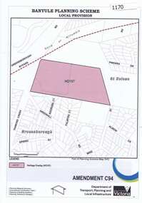
Map, Saxam Heritage Overlay, 2011_
"Saxam" was the home of the Kaye family (1886-1888) then William Santon, a former councillor and Mayor of Heidelberg. Saxam Homestead is a distinctive and substantial timber homestead built in the late 1880s as one of the notable rural properties in the St Helena area. In 2014 the house still stands but is in poor condition with most interior features removed. The site had a heritage overlay as shown. The overlay was reduced in 2014 to protect the house while allowing residential development on the site.Saxam is one of the only remaining farmhouses in the Greensborough area.Copy of map and planning scheme.saxam -
 Running Rabbits Military Museum operated by the Upwey Belgrave RSL Sub Branch
Map
Topographic map of Nui Datmaps, vietnam, army -
 Running Rabbits Military Museum operated by the Upwey Belgrave RSL Sub Branch
Map
Map of the Western Front WW1maps -
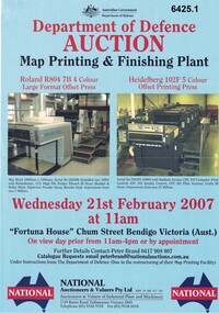 Bendigo Military Museum
Flyer - Department of Defence Auction Flyer- Map Printing and Finishing Plant 21 Feb 2007, Department of Defence Auction Flyer - Map Printing and Finishing Plant 21 Feb 2007, 21 Feb 2007
This Flyer was produced by the Australian Govt Department of Defence for an auction to be held at Fortuna Bendigo on Wed 21 February 2007 at 11am for the sale of Map Printing and finishing Equipment that had been used by the Royal Australian Survey Corps at the Army Survey Regiment. The Flyer lists 76 x items of equipment being Auctioned. Items Auctioned include: Amrap Pallet Stretch Wrapping Machine, Crown 20IMT90 Electric Lift Truck, Roland R804 7B Large Format 4 x Colour Offset Printing Press, Wohlenburg 1850mm programmable Paper Guillotine Model MCS-2, Bauman Stack Lift, Barco Graphics Mega Setta Plus Large Format Image Setter, HP Design Jet 300P Colour Plotter and Heidelburg Speedmaster Model 102F 5 x Colour Offset Printing Press.A4 Auction Flyer, Blue, Double sided and 7 x photos of lithographic equipment. Contains lists of items to be auctioned.royal australian survey corps, rasvy, fortuna, army survey regiment, army svy regt, asr -
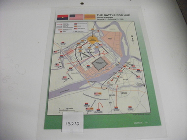 National Vietnam Veterans Museum (NVVM)
Map
January 30-31 1968. Laminated coloured map of South Vietnam headed "The Tet Offensive". Three flags at the top. North Vietnam Army - Red over blue with yellow star in the middle. American stars & stripes flag. SVA Unit - orange base with purple horizontal stripes through the middle. Reverse is a map of Citadel & Imperial Palace of Peace.The battle for Hue, South Vietnam. January 31 - Feb 21, 1968.tet offensive (1968), north vietnam flag, united states flag, south vietnam flag, the battle for hue, hue -
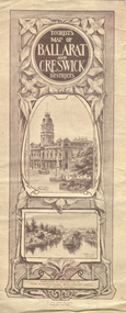 Federation University Historical Collection
Map, Ballarat and Creswick Districts, 1917, 14/03/1917
"... Three designs have been submitted to the Minister of Lands, at the Department's request, for the cover of a tourists' Guide book of the Ballarat and Creswick Districts. ..." (Ballarat School of Mines Principals Monthly Report, August 1916. Cat. No. 1110.12)A folded map of Ballarat and Creswick Districts which includes tourist destinations such as Creswick, Eureka Stockade, Sturt Street and Coliseum. Drawings are by Amalie Feild.ballarat, creswick, feild, amalie feild, ballarat town hall, park lake creswick, eureka memorial, university women -
Whitehorse Historical Society Inc.
Map, Shire of Nunawading (part)
Photocopy of map of part of Shire of Nunawading. area along Whitehorse Road from Box hill to Mitcham.Photocopy of map of part of Shire of Nunawading. area along Whitehorse Road from Box hill to Mitcham. Mitcham Station marked as Emery's Hill.Photocopy of map of part of Shire of Nunawading. area along Whitehorse Road from Box hill to Mitcham.maps, shire of nunawading, box hill, blackburn, nunawading, mitcham, emery's hill -
Whitehorse Historical Society Inc.
Map, Blackburn and Doncaster, 1950, 1950
Map of part of Blackburn and Doncaster from Morgan's Street Directory, 1950. Advertisement for G.S. Grover, Real Estate Agent, Main Road, Doncaster.Map of part of Blackburn and Doncaster from Morgan's Street Directory, 1950. Advertisement for G.S. Grover, Real Estate Agent, Main Road, Doncaster.Map of part of Blackburn and Doncaster from Morgan's Street Directory, 1950. Advertisement for G.S. Grover, Real Estate Agent, Main Road, Doncaster.maps, blackburn, grover, g.s., doncaster -
Whitehorse Historical Society Inc.
Map, Nunawading District
Map of Blackburn, Mitcham and Nunawading District showing schools, public phones, police stations and post offices.Map of Blackburn, Mitcham and Nunawading District showing schools, public phones, police stations and post offices. Scale 20 chains to 1 mile.Map of Blackburn, Mitcham and Nunawading District showing schools, public phones, police stations and post offices. schools, mitcham, nunawading, police, post offices, blackburn, forest hill, vermont -
Whitehorse Historical Society Inc.
Map, City of Nunawading, 1970
Map showing flats of high, medium low and restricted low density, adopted by Council in June 1969.Map showing flats of high, medium low and restricted low density, adopted by Council in June 1969. Scale: 100 ft :1 inchMap showing flats of high, medium low and restricted low density, adopted by Council in June 1969.flats, city of nunawading -
Whitehorse Historical Society Inc.
Map, Aborigines of Bulleen, n.d
Map showing traces of Wurunngeri Tribe to be found in an area which became City of Doncaster and Templestowe, taken from history written by Irvine Green.Map showing traces of Wurunngeri Tribe to be found in an area which became City of Doncaster and Templestowe, taken from history written by Irvine Green.Map showing traces of Wurunngeri Tribe to be found in an area which became City of Doncaster and Templestowe, taken from history written by Irvine Green.aborigines, city of doncaster -
Whitehorse Historical Society Inc.
Map, Yarra River, n.d
Copy of fold-out map 'Loddon 25' included in 'Lilydale', by Grace Aveling. Based on T.H. Nutt's original survey of the Yarra River, 1839.aveling, grace, nutt, t.h., yarra river -
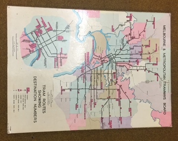 Melbourne Tram Museum
Map, Melbourne & Metropolitan Tramways Board, Del J. Chau, "Tram Routes showing destination numbers", 1972
Titled "Tram Routes showing destination numbers". Map dated 1972, showing routes with route numbers, including short working, names of main destinations, roads, railway stations and rail lines, municipalities, rivers, scales, city section in detail, depots and Sunday only services. In bottom right hand corner has number P.14431, Del J. Chau 1972. The original has been altered to show the Bundoora, La Trobe University and East Burwood lines and the change to Airport West. Type of map that was placed on the rear of the driver's doors of a W Class tramcar.Demonstrates a MMTB produced map used in trramcars.Full colour map or poster printed on heavy cardboard.trams, tramways, mmtb, map, routes -
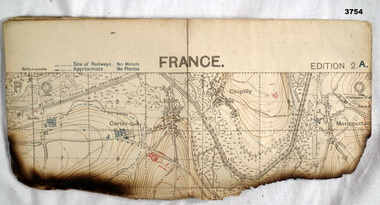 Bendigo Military Museum
Map - TRENCH MAP, FRANCE WW1, 1918
Areas covered on this map, “Hamel, Mericourt, Proyart, Weincourt, Harbonnieres”. Item re William Alexander No 502 AIF. Refer Cat No 3746.3 for his service details.Trench map, France, Edition 2A, sheet 62D S.E, scale 1:20,000, trenches corrected to 22.4.1918, trenches in red. On outside in blue handwriting “62D S.E”map, trench, france -
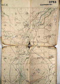 Bendigo Military Museum
Map - TRENCH MAP, FRANCE WW1, 1918
Areas covered on this map, “Coisy, Allonville, Busy, Franvillers” Item re William Alexander No 502 AIF. Refer Cat No 3746.3 for his service details.Trench map, France, Edition 2A, sheet 62D N.W, scale 1:20,000, trenches corrected to 7.5.1918, British trenches in blue.On outside drawn in purple “62D N.W 1:20,000”map, france, trench -
Whitehorse Historical Society Inc.
Map, Tunstall 1945, 1945
A map drawn from memory about 20 years ago by Colin Fraser of the businesses and residents of Tunstall, 1945, including the location of Fraser General Store.A map drawn from memory about 20 years ago by Colin Fraser of the businesses and residents of Tunstall, 1945, including the location of Fraser General Store.A map drawn from memory about 20 years ago by Colin Fraser of the businesses and residents of Tunstall, 1945, including the location of Fraser General Store.tunstall, tunstall railway station, tunstall avenue nunawading, tunstall state school no 4190, fraser, colin -
Whitehorse Historical Society Inc.
Map, Station Street Mitcham
Map of business premises in Station Street Mitcham c. 1940s, drawn by Veronica Stodgell.Map of business premises in Station Street Mitcham c. 1940s, drawn by Veronica Stodgell. Photos of beauty salon manageress Joyce Phillips and Veronica StodgellMap of business premises in Station Street Mitcham c. 1940s, drawn by Veronica Stodgell. station street mitcham, no.9, phillips, joyce -
Clunes Museum
Map, CHARLES FENTON, 1987
TRANSPARENT PLASTIC SHEET WITH A MAP OF CLUNES TOWNSHIP DRAWN IN BLACK WITH TINY WHITE STICKERS DENOTING POINTS OF INTEREST, MOUNTED TO BROWN PAPER AND PINNED IN PLACE ON REVERSE OF BROWN PAPER WRITTEN IN BLACK IN "CLUNES 1987 TRACINGS"clunes 1987, clunes township map -
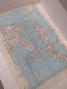 Nhill Aviation Heritage Centre
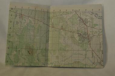
Map - Silk Map, No. 24 south celebes, c1942
Silk maps produced by the USA for the Pacific warWhite woven silk material with printed map and text North Celebes print on the reverse side South CelebesNo. 24 South Celebesusa, us army air force, silk, map, celebes, saam, -
 Warrnambool and District Historical Society Inc.
Original Document, Map: Agricultural area of Ballangeich 1865, 1865
George Eddington arrived in Australia in 1839 and named and established property in 1841 calling the property Ballangeich after a Pass near his home town of Stirling in Scotland. It is situated 151 miles west of Melbourne and to the south of Mortlake and was originally part of the Mortlake shire, which was proclaimed 26th Jan 1864. Nearest streams are the Hopkins Riverand Lyall and Drysdale creek running through good agricultural land. This map relates to the breaking up of large runs which the Victorian government enabled through selection acts of the 1860's. The previously larger runs which were mainly cattle and sheep based were now more open to closer settlement and a greater variety in farming.The lots range in size from approximately 50 acres to around 600 acres.Some areas are set aside for reserves. By 1886 the population of Ballangeich had grown to around 600 with an hotel, three state schools and a church.Tri weekly coaches ran to Colac, Warrnambool and Camperdown providing access to supplies mail and communication. This map is typical of many which were produced in the 1860's in Victoria during a significant period of Victoria's and Warrnambool district history.Rectangular light card paper with black text showing allotments of land The area is coloured in green with scale at bottom right cornerAt the top: Plan of the Agricultural area of Ballangeich 1865 At the bottom left: Prepared by the Board of Lands & Works in accordance with the Amending Land Act 1865 Lands & Survey Office Melbourne 13th April 1865. With signaturehistory of warrnambool, ballangeich, land surveys victoria 1865, lands act 1865 victoria, ballangeich map 1865 -
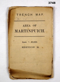 Bendigo Military Museum
Map - TRENCH MAP, FRANCE WW1, 1916
Areas covered by this map are, “Longueval, Delville Wood, Flers, Thiepval”. Item re William Alexander No 502 AIF. Refer Cat No 3746.3 for his service details.Trench map, France, Area of Martin Puch, scale 1:20,000 Edition B, trenches corrected to 24.7.1916, enemy trenches in red.map, trench, france -
 Bendigo Historical Society Inc.
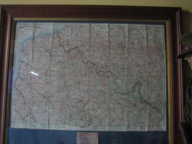
Document - HARRIS COLLECTION: HAMS SQUATTING MAP OF VICTORIA, PORT PHILLIP DISTRICT, NSW
Thomas Ham was a cartographer, engraver, lithographer and publisher in Victoria and Queensland. He compiled and printed several editions of his squatting map, beginning with A map of Australia Felix in 1847 and changing its title to Ham's squatting map of Victoria in 1851. The 1851 edition was accompanied by a key listing the names of all the squatters within squatting districts and counties. Later editions show the existing counties, but some areas of Gippsland and the Australian Alps are still described as 'unsurveyed country'. (State Library Victoria https://www.slv.vic.gov.au/squatting-map-victoria)Folding map enclosed in burgundy cover. Map backed by cloth and bound. Rare, early map of Victoria and neighbouring Port Phillip District of New South Wales. Written on bottom RH corner of map: Ham's Squatting Map of Victoria ( Port Phillip District, New South Wales ) carefully corrected to this date from the Colonial Government Surveys, Crown Lands, Commissioners & Explorers Maps, Private Surveys & c. Respectfully inscribed (with permission ) to His Excellency Sir Chas A. Fitz-Roy Knt, Governor of New South Wales &c &c by his Obedient Servant, The Compiler, 1851. Compiled, engraved and published by Thomas Ham, Melbourne. Proposed and original boundary ( in legend) have been coloured in in blue and pink ink ( later addition ?) Number on map show 'reference to proprietor's Printed on back of map ' J.G. AD 1852, with two cross hatched decorations and two hearts entwined. On other back panel in pencil enclosed in a drawn frame ' G.S.H., 1889, Axedale' (George Harris, Axedale, belongs in Harris Collection) Stamped in purple ink 'Royal Historical Society of Victoria, Bendigo Branch. Written 1959, 53.map, victoria, squatting map -
Whitehorse Historical Society Inc.
Map, State Savings Bank of Victoria, 1921
Map of Box Hill, Blackburn and Tunstall, 1921 from Australian Guide and Business Directory showing site of Box Hill branch of State Savings Bank of Victoria.Map of Box Hill, Blackburn and Tunstall, 1921 from Australian Guide and Business Directory showing site of Box Hill branch of State Savings Bank of Victoria.Map of Box Hill, Blackburn and Tunstall, 1921 from Australian Guide and Business Directory showing site of Box Hill branch of State Savings Bank of Victoria.maps, box hill, blackburn, state savings bank of victoria -
Whitehorse Historical Society Inc.
Map, Nunawading Planning Scheme, 7/06/1994 12:00:00 AM
Local Section maps 1 - 4 with index. Geographical information system land Information Branch. Scale 1:10,000 Shows zoning under planning scheme.Local Section maps 1 - 4 with index. Geographical information system land Information Branch. Scale 1:10,000 Shows zoning under planning scheme.Local Section maps 1 - 4 with index. Geographical information system land Information Branch. Scale 1:10,000 Shows zoning under planning scheme.blackburn, blackburn north, blackburn south, forest hill, heatherdale, maps, nunawading, vermont, vermont south, town planning, burwood east, laburnum -
Whitehorse Historical Society Inc.
Map, VR Box Hill - Blackburn, 1953
Maps of proposed station at Laburnum on Box Hill to Blackburn railway lines, by Victorian Railways, showing boundaries of Victorian Railways land and the proposed boundaries for Laburnum Station.Maps of proposed station at Laburnum on Box Hill to Blackburn railway lines, by Victorian Railways, showing boundaries of Victorian Railways land and the proposed boundaries for Laburnum Station.Maps of proposed station at Laburnum on Box Hill to Blackburn railway lines, by Victorian Railways, showing boundaries of Victorian Railways land and the proposed boundaries for Laburnum Station.laburnum railway station, laburnum street, blackburn, victorian railways