Showing 10465 items
matching plans
-
 Flagstaff Hill Maritime Museum and Village
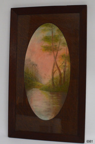
Drawing - Pastel Picture, W.R. Angus (Dr. William Roy Angus), 1925
This large pastel drawing was created by Dr W.R. Angus in 1925, the year after he graduated as a doctor in South Australia. In 1926 Dr Angus was appointed as Medical Assistant to Dr Thomas Francis Ryan, in Nhill, Victoria, where he extended his experiences in radiology and pharmacy. Eventually, in 1939, he and his wife Gladys moved to Warrnambool, Victoria, with their children. The drawing is part of the W.R. Angus Collection, which includes another of the doctor’s pastel drawings and a box of used pastels. The picture was framed by W.H. Rogers & Co. of North Terrace, Adelaide. The business also framed maps and plans. This pastel drawing is locally significant for being the work of Warrnambool doctor, W.R. Angus. It is part of the W.R. Angus Collection, which is significant for still being located at the site it is connected with, Doctor Angus being the last Port Medical Officer in Warrnambool. The collection of medical instruments and other equipment is culturally significant, being a historical example of medicine, administration, household equipment and clothing from late 19th to mid-20th century. Dr Angus assisted Dr Tom Ryan, a pioneer in the use of X-rays and in ocular surgery. The collection includes Army objects, which are examples of items issued to Doctors and Surgeons in the Medical Services of the Australian Army in World War 2. It also includes household items used by Dr Angus and his family from the 1920s in various locations including Warrnambool, together creating an understanding of the furnishing of an early to mid-20th century home.Pastel drawing behind glass in a rectangular wooden frame with an unusual oval wooden matt. The subject is a scene with a pink-tinted sky reflected in a river running between the foot of two hills with trees. The picture was created and signed by W R Angus in 1925. The back is covered in brown paper and has a mounting wire. Inscriptions are on the picture and the back. A remnant of the framer’s label is attached. The picture is part of the W.R. Angus Collection. Signature and date; “W.R.A. / 1925” Printed on label remnant; “—Rogers & Co. / - ORIA STREET / - way Station, North Terrace / “THE CORRECT FRAMERS” / -lise in Map and Plan Mounting / PHONE 5437”flagstaff hill, warrnambool, maritime village, maritime museum, shipwreck coast, great ocean road, drawing, pastel drawing, pastel drawing by w.r. angus 1925, rogers & co., w.h. rogers & co., correct framers, w.r. angus collection -
 Melbourne Tram Museum
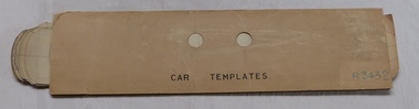
drawing - Folder, Melbourne & Metropolitan Tramways Board (MMTB), "Car Templates", c1920
... Plans ...Cardboard sheet - folded into half used to contain MMTB tram car templates or floor plans. Has "CAR TEMPLATES" written in ink on front and the number "R3432" written in blue pencil in the bottom left hand corner and two thumb holes cut in the front portion. See Reg Item 356 for the actual templates. Cover made from The Prahran and Malvern Tramways Trust timetable sheet giving the times for the first and last cars on each route for Weekdays and Sundays.trams, tramways, mmtb, pmtt, plans, drawings, timetables -
 Bendigo Historical Society Inc.
Document - MARKS COLLECTION: LANSELL'S 190 MINE PLAN
Plan on heavy parchment paper. Printed on bottom of plan 'Lansell's 180 plan' On top RH corner 'Victoria Quartz Mining Co' On LH side 'North Old Chum Co' Plan shows rock formation e.g. quartz lava slide. Plan found in documents from George Lansell auction, donated by Phillipa Marks.bendigo, mining, lansell's 180 mine -
Bendigo Historical Society Inc.
Document - MARKS COLLECTION: SIDE ELEVATION AND GROUND PLAN OF STAIRWAY
Plan drawn on waxed paper. On top 'Side elevation' written in black ink, shows bottom treads of staircase, ornate bottom post of balustrade. On bottom of plan 'Ground Plan' written in black pen, 'Scale 1 Inch to a Foot' Plan contained in Fortuna Villa, George Lansell documents, although Fortuna Villa not written on plan.bendigo, house, fortuna villa -
Whitehorse Historical Society Inc.
Document, Monier Wunderlich Tile Factory, 1989-96
Papers concerning sub-division of the former Monier-Wunderlich Tile Factory site.Papers concerning sub-division of the former Monier-Wunderlich Tile Factory site between Rooks and Mitcham Roads Vermont. Includes City of Nunawading planning documents and correspondence with residents; Wunderlich Residents' Action Group circulars; correspondence and drafts by W & B Gray relating to the proposals.Papers concerning sub-division of the former Monier-Wunderlich Tile Factory site. wunderlich limited, monier-redlands pty ltd, mitcham road, mitcham, rooks road, vermont, nos. 147-157, wunderlich residents' action group, rosstrevor crescent, mitcham, redlands properties, gray, william, gray, beryl -
 Kew Historical Society Inc
Photograph - Double-fronted Edwardian Villa, c.1918
The Kew Historical Society's map collection includes a substantial number of real estate subdivision plans, mainly of Kew but also of surrounding suburbs in Melbourne. Most of the subdivision plans date from the 1920s and 1930s when the districts old homes and local farmland were being split up to accommodate residential growth in the postwar period. These early plans were assembled by a local firm, Jas R Mather & McMillan, which had an office in Cotham Road. Many of the plans, and sometimes photos, were annotated by the agents.Subdivision plans are historically important documents used as evidence for the growth of suburbs in Australia. They frequently provide information about when the land was sold as well as evidence relating to surveyors and real estate and financial agents. The numerous subdivision plans in the Kew Historical Society's collection represent working documents, ranging from the initial sketches made in planning a subdivision to printed plans on which auctioneers or agents listed the prices for which individual lots were sold. In a number of cases, the reverse of a subdivision plan in the collection includes a photograph of a house that was also for sale by the agent. These photographs provide significant heritage information relating house design and decoration, fencing and household gardens.The photograph may also be aesthetically significant depending on the importance of the photographic atelier.On the reverse of a subdivision plan of the Palmyra Estate (Kew) is a photograph of a double-fronted Edwardian villa. The weatherboard and stucco house with high brick chimneys provides a clear indication of the style of curtains and gardens in houses of the period. Holland blinds with lace inserts are used in the left front window. They are combined with long lace curtains. The garden, with its curved pathway is bordered with garden beds that include marguerite daisies and roses. Reflecting a new interest in the Australian landscape, tree ferns and ground ferns are planted closer to the house.houses - kew, architecture - edwardian, real estate photographs -
University of Melbourne, Burnley Campus Archives
Plan, 36 Railway Ave, Armadale, 1991-1997
Sets of plans for a Residential Garden produced by students for an assignment. (1) Tracing paper and paper copies site plan sketch. (2) Janine Bugg - Assessment Preliminary Plan, Concept Plan, Site Inventory and Analysis, Site Elevation A, Section Elevation B dated 26.05.1994. (3) Carmen Skrobonja - Assessment Main Plan & Section Elevation, Concept Plan dated 31.05.1991. (4) G. Mutimer - Preliminary Plan, Section Elevation, May 1994. (5) Melissa King - Assessment, Site Inventory & Analysis, Site Concept Plan, Preliminary Main Plan, Section Elevation, May 1997. (6) Jim Despotellis - Site Inventory & Analysis, Concept Plan, Preliminary landscape Design, 25.04.1994 - 15.05.1995. (Also see B11.0775.) (7) 33 Railway Ave (sic), Colour photographs pasted on paper. (8) Marli Draper - Site Inventory and Analysis, Concept Plan, Preliminary Plan, Perspective Feature Bed. (Also see B11.0773). (9) Cowan (Creations) - Site Inventory and Analysis, Concept Plan, Preliminary Plan, Assessment, 30.05.1994. (10) McRae (Designs) - Site Inventory and Analysis, Preliminary Main Plan, Concept Plan, Section View to Tussock Grass and Eucalyptus, 30.05.1997 - 01.06.1997. (11) Leah Syme - Site Inventory and Analysis.armadale, janine bugg, carmen skrobonja, melissa king, jim despotellis, marli draper, leah syme, g. mutimer, students, assignments -
Federation University Historical Collection
Booklet, Ballarat School of Mines Report to Council on Possible Future Building Developments, 1965, 1965
A foolscap plan with a number of plans relating to possible future building developments at the Ballarat School of Mines. Includes proposed plan for the former M.B. John Site (neaar brew tower)ballarat school of mines, buildings, building developments, e.j. barker, library, engineering and applied science, gaol residences, trades, ballarat junior technical school, materials testing laboratory, martin report, hickman street -
Port Melbourne Historical & Preservation Society
Plan - Auditorium, Port Melbourne Town Hall, A A Millar, Clerk of works, 1915
Plan for "New Auditorium for Town Council Port Melbourne". Floor plan; cross section C/D, cross section A/B; floor plan balcony ground floor; 1915"New Auditorium for Town Council Port Melbourne":Heath, A.V. Town Clerk and Surveyor:A.A. Millar Spray Street, Elwood. Phone BX 1762, Clerk of Work 1915port melbourne town hall, arthur victor heath, town clerks, a a millar, g t reeves -
 Federation University Historical Collection
Plan, Ballarat School of Mines New Workshops, 17/11/1944
Hand drawn planballarat school of mines, new workshops, albert street -
 Greensborough Historical Society
Map, Greensborough Map with Rail Line Plan, 1970s
Central Greensborough area, including railway line and some landowners. Basic map made c. 1902; annotations dated to circa 1970sTwo copies of planParish of Keelbundora, County of Bourke. Central Greensborough areagreensborough, greensborough railway station -
Ringwood and District Historical Society
Envelope, Packet: Planning - Ringwood and Croydon Clippings and Newspaper 1978-1983, 1978-1983
Planning - Ringwood and Croydon -
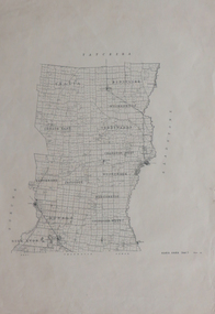
 Federation University Historical Collection
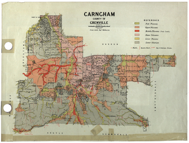
Plan, Carngham, County of Grenville
A plan of Carngham, Victoria.snake valley, timber reserve, poverty point, recreation reserve, carngham, county of ripon, county of grenville, plan -
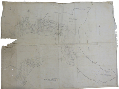 Federation University Historical Collection
Plan, Plan of Merimbula, 1932, 1932
Printed plan on cottonmerimbula, south pacific ocean -
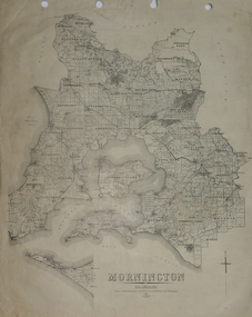 Federation University Historical Collection
Plan, Mornington, 1926, 1926
Printed plan on papermornington, phillip island, western port bay, bass straight, wonthaggi, lang lang, sherwood, nepean, narre worran, ringwood -
 Federation University Historical Collection
Plan, Kara Kara
Printed plan on paperkara kara, tatchera, gladstone -
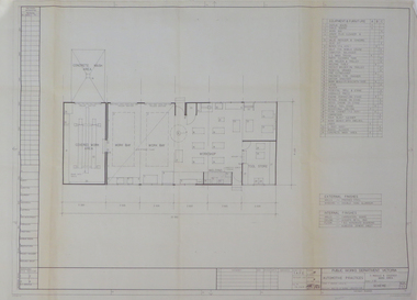 Federation University Historical Collection
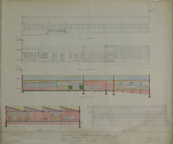
Plan, Ballarat School of Mines Practices Plan, 1981, 1981
Large building plan.ballarat school of mines, john t. green, automotive practices, trades, buildings, architectural plans -
 Federation University Historical Collection
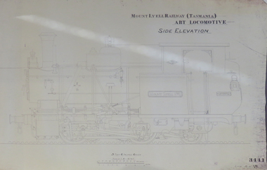
Plan, Mount Lyell Railway (Tasmania) ABT Locomotive Side Elevation, undated
On 29 March 1893 the Mount Lyell Mining and Railway Company was formed. This Tasmanian mining company was often referred to as Mount Lyell. Mount Lyell, and was the dominant copper mining company of the Tasmanian West Coast from 1893 to 1994, and was based in Queenstown, Tasmania. After consolidation of leases and company assets at the beginning of the twentieth century, Mount Lyell was the major company for the communities of Queenstown, Strahan and Gormanston. It closed in 1994. The Mount Lyell mining operations produced more than a million tonnes of copper, 750 tonnes of silver and 45 tonnes of gold since mining commenced in the early 1890s – which is equivalent to over 4 billion dollars worth of metal in 1995 terms.Copy of a plan of a locomotive.mount lyell, locomotive, mount lyell railway, quuenstown, tasmania, strahan, gormamston, railway -
 Federation University Historical Collection
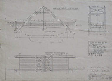
Plan, Plan for a Timber Bridge
Plan for a timber bridgetimber bridge, j. calisto, geoff biddington -
 Federation University Historical Collection
Plan, Ballarat School of Mines Trade Toilet Block Alterations and Renovations, 1976, 04/08/1976
Computer generated planballarat school of mines, toilet block -
University of Melbourne, Burnley Campus Archives
Booklet - Brochure, Botanic Gardens Queen Victoria Gardenss Alexandra Park, 1924
Brochure and plan of gardensgardens -
Creswick Campus Historical Collection - University of Melbourne
Document, 1933
Creswick Working Plan -
Stawell Historical Society Inc
Map - Plan, Earle and Partners, Restoration of Pleasant Creek Courthouse Stawell West 1975, 4/8/1975
Designs for Restoration. Includes details for Public Toilet & Trees.A1 Plan of PrecinctDrawing No. 5 4.8.1975. Pleasant Creek Court of Petty Sessions Built in 1860. Museumstawell historical -
Whitehorse Historical Society Inc.
Map, Sample Plan
Sample Plan of Shireroad construction and maintenance -
 Unions Ballarat
Plan - Photograph: Trades Hall building architects' design, 1886
Original architects' drawings for the construction of Trades Hall, Ballarat. November 5th 1886 the building committee called for tenders for the erection of a Trades Hall on the following conditions. The amount to be expended to be no more than £3,000; bluestone foundations; the front of the building to be of Grampians freestone and walls of brick. Building to be 3 storeys high, containing 14 rooms with a hall capable of seating 600 persons, roof to be of slate and workmanship and material to be of the best quality. The design submitted by Messrs James and Piper was accepted subject to amendment.Relevance to the history of Trades Hall, Ballarat.Paper - architects' plans.btlc, ballarat regional trades and labour council, ballarat trades and labour council, ballarat trades hall, eight hours anniversary committee, james and piper, architects' drawings, building -
University of Melbourne, Burnley Campus Archives
Plan, Proposed Site for Plant Science Laboratory and Glasshouse Block, 1964
Plan on tracing paper.laboratory, glasshouse -
University of Melbourne, Burnley Campus Archives
Plan, Proposed BIH Enclosure Rear S.A.B. V.C.A.H. Burnley, c. 1980
Plan on tracing papervcah, burnley -
 Friends of Ballarat Botanical Gardens History Group
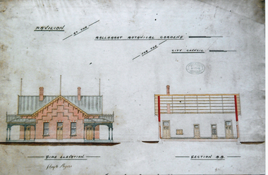
Photograph - Digital image - jpg, Gardens Pavilion design, Ballaarat
colour photograph of planpavilion plan, ballaarat botanical gardens, circa 1890 -
 Friends of Ballarat Botanical Gardens History Group
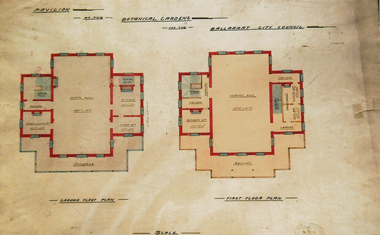
Photograph - Digital image - jpg, Gardens pavilion floor plan, Ballaarat
Colour photograph of a planplan, gardens pavilion, ballaarat circa 1890 -
 Melton City Libraries
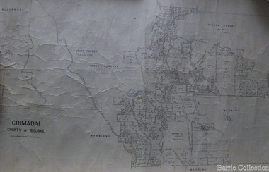
Map, Coimadai County of Bourke, 1911
Town Plan of Meltoncouncil