Showing 2159 items matching " reef"
-
 Bendigo Historical Society Inc.
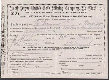
Document - KELLY AND ALLSOP COLLECTION: SHARE CERTIFICATES - NORTH ARGUS UNITED GOLD MINING CO, 02/03/1894
Document. KELLY & ALLSOP COLLECTION. Two share certificates issued by the North Argus United Gold Mining Company, No Liability, Moon Reef, Garden Gully Line, Eaglehawk. Certificate Nos. 2131 & 2132 each of 100 shares issued to N.Kershaw of Bendigo on 2 March 1894. Each share of 10 shillings each raised 15,000 Pounds from 30,000 shares. Certificates signed by J.H.Kirkwood, Manager.North Argus United Gold Mining Co.business, stockbroker, kelly & allsop, kelly & allsop collection, share certificates, north argus united gold mining co., n.kershaw, j.h.kirkwood. -
 Bendigo Historical Society Inc.
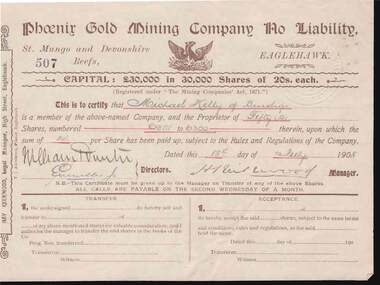
Document - KELLY AND ALLSOP COLLECTION: SHARE CERTIFICATE - PHOENIX GOLD MINING CO, 18/07/1908
Document. KELLY & ALLSOP COLLECTION. Share Certificate No. 507 issued by the Phoenix Gold Mining Company, No Liability, St Mungo and Devonshire Reefs, Eaglehawk. Certificate represents 50 shares at 20 shillings each. Capital raised was 30,000 Pounds from 30,000 shares. Certificate issued to Michael Kelly of Bendigo on 18 July 1908. Signed by Hay Kirkwood, Legal Manager, High St, Eaglehawk.Phoenix Gold Mining Co.business, stockbroker, kelly & allsop, kelly & allsop collection, share certificate, phoenix gold mining co., michael kelly, hay kirkwood -
 Bendigo Historical Society Inc.
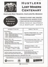
Document - GREAT EXTENDED HUSTLERS GOLD MINE: LOST MINERS FLYER FOR CENTENARY OF MINE DISASTER
On May 2nd 1914, 7 miners were killed in a dynamite explosion in the Great Extended Hustler's Gold Mine. It was Bendigo's worst mining disaster and although an inquest found it was an accident, no cause for the explosion was found.Advertising flyer for an event held on May 3-4 2014, to mark the centenary of the mine disaster that killed 7 minersat the Great Extended Hustlers mine. Other activities included a Specimen Cottage exhibit; guided walks around the Hustlers Reef Reserve; displays on site and talks by various speakers on the mine disaster and mining technology. Event was organised by the Bendigo Historical Society in conjunction with the Hustlers Reserve committee. -
 Bendigo Historical Society Inc.
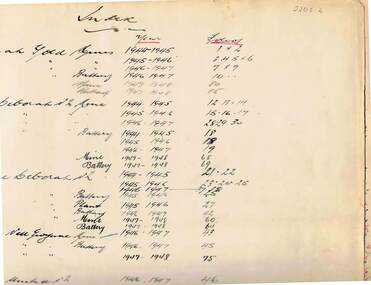
Document - MCCOLL, RANKIN AND STANISTREET COLLECTION: WAGES BOOK, VARIOUS MINING COMPANIES, 1945-50
Document: McColl, Rankin and Stanistreet: Deborah: wages book, various mining companies. Listing wages and tax paid for employees of : Deborah Gold Mines and batteries, North Deborah mine and batteries, Central Deborah mine and batteries,, Central Nell Gwynne, Deborah United No. 2, South Deborah, Deborah Extended, Nell Gwynne Reef, East Clarence, Golden Carshalton, North Virginia. Indexed in front cover.organization, mining, mccoll, rankin and stanistreet, mccoll, rankin and stanistreet: gold mining, deborah mines -
 Bendigo Historical Society Inc.
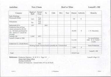
Document - LANSELL'S BIG 180 MINE - PRODUCTION NOTES FOR LANSELL'S 180 MINE
Two handwritten pages, and typed copy of same, of production for Lansell's 180 Mine on the New Chum Reef. Notes give the name of the mine, depth, year, ounces of gold produced and remarks. Mentioned are: Early Workings, Weymouth, Wittschieler & Co, Lansell's 180, Lansell's Estate, Endeavour Co (South Block), J. N. Macartney. Both pages are almost the same. They are page No 111. Albert Richardson Collection. document, gold, lansell's big 180 mine, lansell's big 180 mine, production notes for lansell's 180 mine, weymouth, wittschieler, ballerstedt & co, lansell's 180, lansell's estate. endeavour co (south block), j n macartney, production statistics b m n l page 111, bendigo goldfields history & production, general index of coys & reefs -
 Bendigo Historical Society Inc.
Map - FORTUNA HUSTLER'S MINE - TRANSVERSE SECTION OF THE FORTUNA HUSTLER'S MINE
Transverse Section of the Fortuna Hustler's Mine on the Hustler's Line of Reef, Bendigo. Bulletin No 33, Plate No III. Drawing shows poppet legs on the surface and Sill of Shaft 745.38 feet above Sea Level. Shows levels and their depths, geographical features and stone encountered. Reference table to stone and geographical features. Geographical Survey of Victoria emblem. Signed by H A Whitelaw, Underground Survey Office, Bendigo. mining, fortuna hustler's mine, hustler's line of reef, geological survey of victoria, underground survey office bendigo, h a whitelaw -
 Bendigo Historical Society Inc.
Document - ROBERTS' NUGGET 1931
Two-page document, one typed, one handwritten. Extract from the Bendigo Advertiser, Monday 3 August 1931. The Roberts' nugget was found in the Whipstick Forest a short distance from the Crystal Reef, Neilborough by Leslie John Roberts. It was found 30 cm down in clay and weighed 70 ounces. Leslie and his father were unable to find work and were presumably prospecting in the Whipstick.bendigo, mining, roberts' nugget -
 Bendigo Historical Society Inc.
Map - COMET MINE - LONGITUDINAL SECTION COMET MINE
Longitudinal section of the Comet Mine on the Hustler's Line of Reef Bulletin No 33, Plate No XXVI signed by H. S. Whitelaw, Underground Survey Office Bendigo, September 1913. Map shows datum lines, depths of levels, approximate boundaries and references to other plans. Note - Plates 4, 8, 13, 20, 26 and 31 form a Longitudinal Section from Fortuna Hustler's to Hustler's Consols Mine. Geological Survey of Victoriamining, parish map, hustler's line of reef, longitudinal section of comet mine bulletin no 33 plate no xxvi, h s whitelaw -
 Bendigo Historical Society Inc.
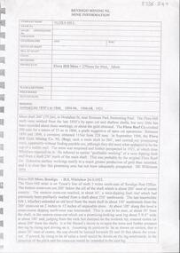
Administrative record - East Moon Gold Mining Company Mine Manager's Report Book, 1919 - 1920
February 1933: East Moon Gold Mining Co. N.L. has been formed with a capital of £25,000 in 36,000 shares of 10/- each issued at 1/-. The company will work an extensive lease on the Paddy’s Gully and Derby lines of reef at Eaglehawk. A shaft was sunk on the Paddy’s Gully line in the property of the New Moon Co. some years ago to a depth of 380 ft. and another shaft was sunk by the same company on the Derby line of reef to 134 ft. In the Paddy’s Gully shaft a large body of spurs 10ft wide at the 256ft plat was exposed and continued downward for 36 ft (56ft?) before passing out of the shaft to the east. A little gold was seen in the stone but no work was done. The development of this formation will be the first work undertaken by the new company. (The Sun News Pictorial Monday 20th February 1933, page 23) Black hard cover book, red binding on spine, one hundred and eighty eight pages of which sixty five are used. Label on front cover: 'East Moon G.M.C . N.L.' Book contains: a. handwritten reports from Alfred Jorgensen regarding the installation of the plant and machinery at the mine b. reports from E.G. Robertson, the Manager of the East Moon Gold Mining Company. Typed report by E.G. Robertson, 8th July 1935 reports on the Paddy's Gully shaft, the Derby shaft and the Hustlers shaft. Entries date from 20th July 1933 to 22nd. August 1935. Mine Manager's book forms part of the Margaret Roberts Collection of Mining records.bendigo, margaret roberts, legal managers, mine manager, east moon gold mining company n.l., e.g. robertson mine manager, alfred jorgensen contractor, paddy's gully shaft, derby shaft, hustler's shaft, -
 Bendigo Historical Society Inc.
Document - DEBORAH REEF PROJECT ENVIRONMENT EFFECTS STATEMENT
Two page document. On top, first page ' Bendigo Mining N.L., Deborah Reef Project, Environment Effects Statement, Summary Brochure'. Poppet head on top LH corner of document. A map of central Bendigo is drawn on page 1 and shows the location of the proposed processing plant near the Airport. Further maps on page 2 and 3 show the North Deborah Mine Site, the pipeline route and the airfield site. The summary brochure provides an outline of the material contained in the Environment Effects Statement and proposed planning scheme amendments upon which, the Deborah Reef Project will be assessed. Page four lists the issues that impact on this submission: planning and land use; socio economic environment; traffic; discharges to air; water management; explosives storage and handling; subsidence; heritage; flora and fauna and landscape and visual assessment. The 16th March, 1989, is the date given for submissions to be lodged in regard to this project.Bendigo Mining N.Lbendigo, mining, deborah reef project -
 Bendigo Historical Society Inc.
Document - ROMANCE OF THE GOLDFIELDS
Document. 8 page typed document titled 'Romance of the Goldfields'. (2 copies). 'Copy' is typed at the top of document. Mentions the gold rushes of Bendigo and Forest Creek. Mentions, Messrs. Gibson & Fenton, Mr Robert Ross Haverfield, Kennedy and Farrell, Asquith, Ben Hall, William and Walter Sandbach, Ron O'Donnell, Johnson, Bypass, Latham, Watson, Bell, Mr J B Watson, Mr George Lansell. Also mentions Gold Yields. Mentions Mines - Advance, Great Extended Hustlers, Garden Gully, New Chum, Victoria, Kent Mine, Golden Fleece, Richard Heales, Cornish United, Great Extended Hustlers, Tribute Company, Williams United, South New Moon, New Moon, Carlisle Group, Johnson's Reef, North Johnson's, Hercules and '180'. Envelope that this document was in is marked 'Notes re - Romance of Goldfields, Premier Companies, Sebastian Mining Leases, Resources of Bgo Goldfields, Sheepshead Line of Reef'.cottage, miners, romance of the goldfields, bendigo, forest creek -
 Bendigo Historical Society Inc.
Document - Kangaroo Flat Gold Mine Collection: Flora Hill Mine Report, 6th November 1985
Kangaroo Flat Gold Mine Collection. Eight pages (photocopy) of information relating to the Flora Hill Mine, Flora Hill, Bendigo. On first page: 'Bendigo Mining N.L. Mine Information' First two pages contain a summary of the research undertaken by Bendigo Mining N.L. with six additional photocopied pages of annotated copies of mining records. The main Flora Hill Mine shaft 260 ft (79.2m) in Houlahan Street, near Brennan Park Swimming Pool. The Flora Hill reefs were worked from the late 1850's by open cut and shallow shafts, but very little has been recorded about these working or the gold obtained. The Flora Reef Co crushed 200 tons for a return of 25 oz in 1866, a grade suggestive of open cut operations.' The mine was re-opened in 1921, at which time Whitelaw wrote a report. An extract from Whitelaw's report (24th March, 1921) is included in the report. gold mining, bendigo, flora hill mine, south flora reef gold mining company, bendigo mining n.l. -
 Bendigo Historical Society Inc.
Document - South New Moon Syncline Gold Mine No Liability 1934, James Phillips, January 20th 1934
Two page document, carbon copy typed on flimsy paper. On first page ' South New Chum Syncline Gold Mine No Liability', Bendigo. January 20th 1934. Mine Manager's report, Jas. Phillips typed on bottom of second page. Content includes: 'The level south at the 110 ft was driven over 35 years ago by the late Geo Phillips who had a 20 head mill on the lease and as far as I can remember its about 200 ft south and of course the reef iow well above a few feet in on account of it rising in that direction and thousands of tons has been taken out of that particular block and crushed.... the writer worked on that reef in his younger days and we connected with some old workings above us known as the German's Workings collapsed and closed up from the 100 ft level to the surface'. Document is part of the Margaret Roberts Mining Collection. south new moon syncline gold mine, geo phillips, james phillips, george phillips, gold mine, reef lines -
 The Beechworth Burke Museum
Photograph, Unknown
The A1 Gold Mine is located north of Woods Point, near Jamieson, in the Upper Goulburn region of Victoria. Gold was discovered at the A1 site in 1861 and mining operations began in 1864. The A1 Mine Settlement refers to a small township known variously as Castle Reef, Castle Point, and Raspberry Creek, which developed in the 1860s around mining industry centred on a crushing machine that worked the three gold reefs in the area. Historically, the name "A1"referred to the high quality of gold found in the quartz reefs at depths of at least two thousand feet. Along with the Morning Star mine at Woods Point, the A1 gold mine produced almost sixty percent of Victoria's gold output in the 1950s to 1970s and continued operating until 1992 when it went into administration. Operations at the site were revived in 2016 and the A1 Mine is now considered one of Victoria's premier gold mines. The A1 mine is part of the extensive and prospective Lachlan Fold Belt, a north-west trending belt of tightly folded Early Devonian sedimentary rocks extending from New South Wales to Victoria. Mineralisation is hosted within or immediately adjacent to diorite dykes. Contemporary development of the 'Queens Lode' at the A1 mine signals a move from high-grade, narrow vein airleg mining into larger scale, mechanical mining designed to increase ore production volume. This original, undated photograph of the A1 Mine appears to depict an area or phase of disuse or abandonment. The aged and humble appearance of the cottage suggests association with the historical A1 Mine Settlement, therefore the image may have been taken prior to the 1950s-1970s revival period in which the A1 mine is known to have produced high gold yields. The photograph contributes to our understanding of the A1 Gold Mine's impact on the landscape and the social, environmental impacts of mining on communities and may be compared with others in the Burke Museum's extensive collection of mining photographs to deepen our understanding of mining in the Jamieson area.Black and white rectangular photograph printed on photographic paperReverse: 5577 / A1 Mine / Near Jamieson / Vic. /burke museum, beechworth museum, beechworth, gold fields, gold rush, victorian gold rush, mining tunnels, gold ming history, colonial australia, australian gold rushes, mining technology, beechworth historic district, indigo gold trail, indigo shire, upper goulburn shire, jamieson, woods point-walhalla goldfield, a1 gold mine, victorian high country, modern mining methods, orogenic gold province, gold mineralisation, devonian, dykes -
 Waverley RSL Sub Branch
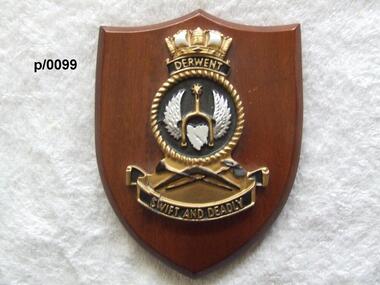
Plaque H.M.A.S. Derwent
HMAS Derwent (F22/DE 22/DE 49), named for the Derwent River, was a River class destroyer escort of the Royal Australian Navy (RAN). Commissioned in 1964, the ship operated during the Indonesia-Malaysia Confrontation, and was used for filming of the British drama series Warship. The ship was decommissioned in 1994, and was scutted as an artificial reef after use for ship survivability testsInsignia od H.M.A.S. Derwent on wooden shieldH.M.A.S. Derwenth.m.a.s. derwent -
 Glenelg Shire Council Cultural Collection
Book, Halstead Press, Wreck of the Admella, 1966
Blue hard-copy book. Gold text on spine. Two double-sided pages of black & white photos half way through book. Book has dust jacket with coloured reproduction of a painting of the wreck of the Admella, by Charles Hill. Photo of author inside back of dust jacket.admella, portland lifeboat, book -
 Bendigo Historical Society Inc.
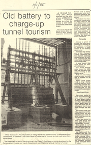
Document - LONG GULLY HISTORY GROUP COLLECTION:OLD BATTERY TO CHARGE-UP TUNNEL TOURISM
Photocopy of a newspaper article titled Old battery to charge-up tunnel tourism. There is a photo of a Thompson's Foundry battery which is being re-erected at the site of the North British mine on Parkin's Reef, near Carman's tunnel. The battery was recovered from a deep gully at Bola Creek. Other works include restoration of quartz roasting kilns and cyanide vats. Written at the top of the article is a date 11/1/85.bendigo, history, long gully history group, the long gully history group - old battery to charge-up tunnel tourism, thompson's foundry, parkin's reef reserve, conservation forests and lands department, carman's tunnel, north british mine, carman's tunnel committee, dr doug kemsley, the prospectors' and miners' association of victoria, mr ken garden -
 Bendigo Historical Society Inc.
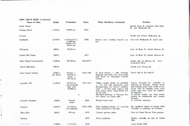
Document - LONG GULLY HISTORY GROUP COLLECTION: NEW CHUM REEF MINE STATS
Copy of a page titled New Chum Reef (Continued). Listed is the name of Mine, Depth, Production, Dates, Plant, Machinery, Comments and Position. Mines listed are:- Little Chum, Young Chum, Craven, Garibaldi, Ellesmere, South Old Chum, New Chum Consolidated, North Ellesmere, New Chum United, Abraham Lincoln Battery, Lansell's 222, Fortuna Battery, Lansell's Fortuna, Lazarus, Lazarus, West End and Pioneer,bendigo, history, long gully history group, the long gully history group - new chum reef mine stats, little chum, young chum, craven, garibaldi, ellesmere, south old chum, new chum consolidated, north ellesmere, new chum united, mt alvernia hospital, abraham lincoln battery, lansell's 222, fortuna battery, fortuna, private tunnel, lansell's fortuna, lunt, lazarus, chum hill, lazarus, west end, army survey unit, pioneer -
Bendigo Historical Society Inc.
Map - DEVONSHIRE GROUP OF MINES
Small map of Devonshire group of mines, Bendigo. Scale 8 chains to 1 Inch. Issued by M. P. Kelly sharebroker, Bendigo. Showing Hercules and Energetic, Pearl, New Victoria Catherine,, New St Mungo, xtended south devonshire, South Devonshire, United Devonshire,duchess of Edinburgh, Phoenix, South st Mungo, Lady Barkly, St. Mungo, Sadowa, Ellenborough, Williams' United, Catherine Reef United.bendigo, mining, devonshire mine -
 Bendigo Historical Society Inc.
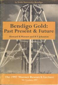
Book - BENDIGO GOLD: PAST PRESENT & FUTURE, 1997
A 30 page soft cover booklet 'Bendigo Gold: Past Present & Future' by Howard K Worner and R F Johnston. The 1977 Worner Research Lecture on 9 October 1997 at the Latrobe University, Bendigo. Part 1 History and Geology by HK Worner Part 2 Refractory Gold Ores by RF Johnston Includes sketches of reefs Published by Latrobe University, Bendigo and printed by Media Services, Latrobe UniversityH K Worner & R F Johnston -
 Bendigo Historical Society Inc.
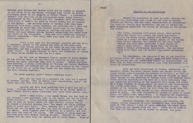
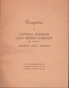
Document - MCCOLL, RANKIN AND STANISTREET COLLECTION: CENTRAL DEBORAH GOLD MINE NL: PROSPECTUS, 1939
Document: McColl, Rankin & Stanistreet Collection: Central Deborah Gold Mine NL - 4 copies of prospectus. Buff covered booklet. Written on front ' Prospectus of Central Deborah Gold Mining Company No Liability Deborah Reef, Bendigo. To be incorporated under the Provisions of Part II of the companies Act 1938. Victoria.' Details capital, proposed directors and manager. Contains map of Central and North Deborah mines and Monument Hill.organization, business, central deborah gold mine, mccoll, rankin & stanistreet collection: central deborah gold mine nl. gold mining -
 Bendigo Historical Society Inc.
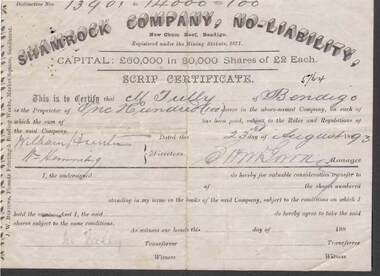
Document - KELLY AND ALLSOP COLLECTION: SHARE CERTIFICATE - SHAMROCK COMPANY, 23/08/1893
Document. KELLY & ALLSOP COLLECTION. One share certificate issued by the Shamrock Company, New Chum Reef, Bendigo, representing 100 shares at Two Pounds each. Capital raised was 60,000 Pounds from 30,000 shares. Share Nos. 13901 to 14000 issued to M.Tully of Bendigo on 23 Aug 1893. Certificate signed by S.H.McGowan, Manager. Printed by J.W. Burrows, Phoenix Printing & Binding Works, Market Square, Sandhurst.Shamrock Co.business, stockbroker, kelly & allsop, kelly & allsop collection, shamrock company, new chum reef, share certificate, m.tully, s.h.mcgowan, j.w.burrows. -
 Bendigo Historical Society Inc.
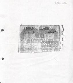
Newspaper - Kangaroo Flat Gold Mine Collection: Article, Facelift for Derelict Mining Sites, 6th November 1985
Newspaper article, (photocopied onto A4 paper) Bendigo Advertiser November 6th, 1985, headed '£100,000 facelift for derelict mining sites?' Article describes how the Bendigo Council were seeking a loan from the Goldfields Revolving Fund for the restoration of the Victoria Hill area and for the restoration of the relics and poppet legs of the Central Nell Gwynne, the Nell Gwynne Reef Mine, the North Deborah and the Big Deborah Mine sites.Written in black pen on right hand side: B'go Adv. Nov. 6th. '85gold mining, nell gwynne mine, north deborah mine, big deborah mine, poppet legs, bendigo, restoration -
 Bendigo Historical Society Inc.
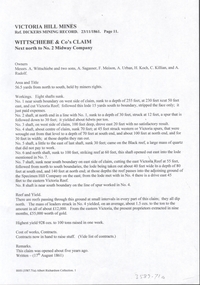
Document - VICTORIA HILL - WITTSCHIEBE & CO'S CLAIM
Two copies (a & b) of handwritten notes on Victoria Hill - Wittschiebe & Co's Claim. Notes mention names of owners: Messrs. A Wittschiebe and two sons, A Sagasser, F Meison, A Urban, A Koch, C Killian and A Rudolf. Also mentioned are Area and title, workings, eight shafts were sunk, reef and yield, cost of works, contracts and remarks. Ref. Kickers Mining Record 23/11/1861 Page 11.document, gold, victoria hill, wittschiebe & co's claim, dickers mining record 23/11/1861, a wittschiebe, a sagasser, f meison, a urban, a koch, c killian, a rudolf, no 2 midway company, specimen hill company -
 Bendigo Historical Society Inc.
Map - HUSTLER'S ROYAL RESERVE NO 2 MINE - PLAN OF THE HUSTLER'S ROYAL RESERVE NO 2 MINE
Plan of the Hustler's Royal Reserve No 2 Mine on the Hustler's Line of Reefs Bulletin No 33, Plate No VI. Boundary of Leases No 8898 and 8897 shown. Various levels shown and some geographical features. Geological Survey of Victoria emblem. H . Harman, Director, W. Dickson, Secretary for Mines and The Hon. J. Drysdale Brown, Minister of Mines and signed by H Whitdon, Underground Survey Office, Bendigo, September 1913. mining, parish map, hustler's royal reserve no 2 mine, hustler's line of reefs, geological survey of victoria, h herman, w dickson, the hon j drysdale brown mlc -
 Bendigo Historical Society Inc.
Map - UNITED HUSTLER'S & REDAN MINE - TRANSVERSE SECTION UNITED HUSTLER'S & REDAN MINE
Transverse Section of the United Hustler's & Redan Mine on the Hustler's Line of Reefs Bulletin No 33, Plate No XXIX. Map has drawing of poppet legs on the surface, depth of levels, type of stone encountered and some geological features. Sill of shaft 745.62 ft above sea level. Map has Geological Survey of Victoria emblem and signed by H S Whitelaw, Underground Survey Office Bendigo, 'September 1913. mining, parish map, united hustler's & redan mine, hustler's line of reef, geological survey of victoria, h s whitelaw -
Bendigo Historical Society Inc.
Document - Fortuna Bendigo, letter of re classification by the National Trust and History Brochure, 20/10/2008
The Fortuna Villa is an expansive Victorian mansion built entirely on the profits of Bendigo's lucrative gold reefs. Established by the wealthy Ballerstedt family in the 1860s, it was purchased and expanded in the 1870s by George Lansell, who was to become one of Australia's wealthiest men. Fortuna villa and gardens were once occupied and cared for by the Australia Army Survey Regiments since 1942 for over thirty years.Classification Report and Notes on the history of Fortuna from the National Trust to the Bendigo Council 20th October 2008; tourist brochure for Fortuna; it includes photographs and detailed history of George Lansell's involvement in the property and his mining history.history, national trust bendigo collection, bendigo, fortuna, george lansell, mining -
 Bendigo Historical Society Inc.
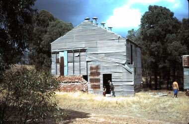
Slide - HORWOOD COLLECTION: NEW MOON, c1978
Just north of the South New Moon mine on the Garden Gully reef, off the Bendigo/Pyramid Road, the New Moon mine began in 1867. In 1878 it purchased the lease of the adjoining Robin Hood Coy. The mine closed in 1917 and was reopened by the Bendigo Amalgamated Coy. in 1928 and closing for good in 1932. Remnants of the third largest crushing battery in the district can still be seen.Horwood Collection - New Moon. Corrugated iron shed at the site of the New Moon Mine site. Remnants of brick mine footings on LH side of shed. Markings; Moon, Eaglehawk. SEP78M Made in AustraliaKodakmine, gold, new moon., horwood collection - new moon. shed at the site of the new moon mine site -
 The Beechworth Burke Museum
Photograph - Photograph - Reproduction, Unknown
This image is a reproduction of an 1899 original depicting the 'Williams Good Luck Mine' on the Mopoke Reef (also called 'Morepork Gully') in the Dingle Ranges, approximately three miles from Beechworth. The foreground of the image is littered with piles of smashed rock and detritus, known as ‘mullock’, beside a reinforced mine shaft, a vertical access passageway allowing miners to enter the mine and haul ore out using lifting technology such as a poppet heads, whims or windlasses. A group of miners and a dog appear close to an open-sided miner’s hut. Following the discovery of gold at Beechworth in 1852, rushes quickly followed at surrounding creeks and gullies in the district. In the late nineteenth and early twentieth centuries, small syndicates of miners continued to work old or abandoned quartz reefs, often persisting without the assistance of heavy machinery to remove the large amounts of rock, in order to obtain yields at ever greater depths. The group of miners in this photograph are Mr. Roger Williams and Sons, who revived operations at the ‘Old Good Luck’ mine on the Mopoke Reef in the Dingle Range near Beechworth around 1892, working the site for more than two decades. An emigrant from Cornwall with experience in the tin mining industry, 19 year old Roger Williams senior sailed to New Zealand in 1840, then to Australia where he spent time in the Bendigo Gold Fields before settling in Beechworth in the early 1860s. Mr Williams senior worked on various mining activities in the district, including the Rocky Mountain Tunnel project. Conversant with the character of gold-bearing reefs in the area, the syndicate dug an eight hundred foot tunnel, digging down as far down as two hundred feet with little capital save their labour, to connect and provide better working access to the mass of reefs and veins in the vicinity. Progress was hampered by poor air quality charged with fumes from dynamite and large quantities of rock had to be crushed to obtain payable yields. The Victorian Goldfields are filled with ruins and remnants of the area's rich mining history, ranging from small alluvial diggings to the remains of huge mining companies. Site names often changed several times throughout the nineteenth and twentieth centuries. Some sites were abandoned and forgotten, others were worked continuously over many decades. The names of mines were often repeated at different locations throughout the Victorian Goldfields. For example, there is a Mopoke Gully heritage mine near Fryers Creek, Victoria. 'Mopoke' is a common onomatopoeic name for Morepork and Australian Boobook owls. This image has historical, social and research significance for patterns of emigration during of the Victorian Gold Rush, and the historical, social and environmental impacts of mining at Beechworth at the turn of the nineteenth and twentieth centuries. As gold became scarce and government support and large company investment waned, poor hard-working miners laboured intensively to make a living through periods of high unemployment. This image can be compared and studied alongside other historical mining photographs and objects in the Burke Museum Collection. It has potential to improve our understanding of miners working conditions and the shifting character of mining in the Beechworth district. Black and white rectangular reproduction photograph printed on matte photographic paper.Obverse: Williams Good Luck Mine Beechworth / Roger! / Reverse: 6858 / burke museum, beechworth museum, beechworth, gold fields, gold rush, victorian gold rush, gold ming history, colonial australia, australian gold rushes, mining technology, beechworth historic district, indigo gold trail, migration, indigo shire, good luck gold mine, victorian goldfields, mining syndicates, gold fever, quartz-mining, small-scale mining, old good luck mine, mopoke gully, quartz reefs beechworth -
 The Beechworth Burke Museum
Photograph
This image is a reproduction of an 1899 original depicting the 'Williams Good Luck Mine' on the Mopoke Reef (also called 'Morepork Gully') in the Dingle Ranges, approximately three miles from Beechworth. A large opening to a mine can be seen behind the men in the photograph, with a wheeled cart on a track leading to the men's position, where the soil and rocks have been hauled away. This photograph interestingly contains dogs alongside the miners. While dogs have been recorded as deterrents to thieves in the Victorian goldfields, these dogs appear as companions to these men. Following the discovery of gold at Beechworth in 1852, rushes quickly followed at surrounding creeks and gullies in the district. In the late nineteenth and early twentieth centuries, small syndicates of miners continued to work old or abandoned quartz reefs, often persisting without the assistance of heavy machinery to remove the large amounts of rock, in order to obtain yields at ever greater depths. The group of miners in this photograph are Mr. Roger Williams and Sons, who revived operations at the ‘Old Good Luck’ mine on the Mopoke Reef in the Dingle Range near Beechworth around 1892, working the site for more than two decades. An emigrant from Cornwall with experience in the tin mining industry, 19 year old Roger Williams senior sailed to New Zealand in 1840, then to Australia where he spent time in the Bendigo Gold Fields before settling in Beechworth in the early 1860s. Mr Williams senior worked on various mining activities in the district, including the Rocky Mountain Tunnel project. Conversant with the character of gold-bearing reefs in the area, the syndicate dug an eight hundred foot tunnel, digging down as far down as two hundred feet with little capital save their labour, to connect and provide better working access to the mass of reefs and veins in the vicinity. Progress was hampered by poor air quality charged with fumes from dynamite and large quantities of rock had to be crushed to obtain payable yields. The Victorian Goldfields are filled with ruins and remnants of the area's rich mining history, ranging from small alluvial diggings to the remains of huge mining companies. Site names often changed several times throughout the nineteenth and twentieth centuries. Some sites were abandoned and forgotten, others were worked continuously over many decades. The names of mines were often repeated at different locations throughout the Victorian Goldfields. For example, there is a Mopoke Gully heritage mine near Fryers Creek, Victoria. 'Mopoke' is a common onomatopoeic name for Morepork and Australian Boobook owls.This image has historical, social and research significance for patterns of emigration during of the Victorian Gold Rush, and the historical, social and environmental impacts of mining at Beechworth at the turn of the nineteenth and twentieth centuries. As gold became scarce and government support and large company investment waned, poor hard-working miners laboured intensively to make a living through periods of high unemployment. This image can be compared and studied alongside other historical mining photographs and objects in the Burke Museum Collection. It has potential to improve our understanding of miners working conditions and the shifting character of mining in the Beechworth district.Sepia coloured rectangular photograph printed on gloss photographic paper mounted on card. Obverse: Williams/ Good/ Luck Reverse: A02498/ 1997. 2498/ Good Luck/ Mine/ 1899/ Mopoke. burke museum, beechworth museum, beechworth, gold fields, gold rush, victorian gold rush, gold ming history, colonial australia, australian gold rushes, mining technology, beechworth historic district, indigo gold trail, migration, indigo shire, good luck gold mine, victorian goldfields, mining syndicates, gold fever, quartz-mining, small-scale mining, old good luck mine, mopoke gully, quartz reefs beechworth