Showing 110511 items matching " roads"
-
 Lakes Entrance Historical Society
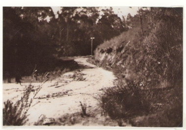
Photograph - Old Bungs Rd. 1927, c1927
This was the old coach road to Orbost which went from Lakes Entrance to Orbost via Lake Tyers.Black and White photograph of old Bunga Road crossing, Lake Tyers.roads and streets, development -
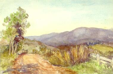
 Marysville & District Historical Society
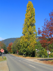
Photograph (Item) - Colour photograph, Unknown
A digital copy of a colour photograph taken along Falls Road in Marysville in Victoria.A digital copy of a colour photograph taken along Falls Road in Marysville in Victoria.falls road, marysville, victoria, photograph -
 Marysville & District Historical Society
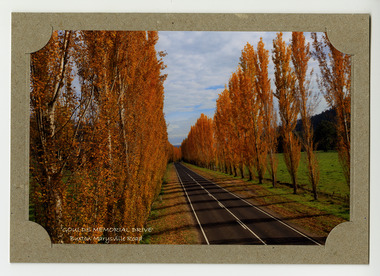
Photograph (item) - Colour photograph, Donovan Wilson, 'GOULDS MEMORIAL DRIVE'- Buxton Marysville Road, Post 2009
A colour photograph taken of Goulds Memorial Drive on the Buxton Marysville Road in Victoria.A colour photograph taken of Goulds Memorial Drive on the Buxton Marysville Road in Victoria. The planting of the avenue of Lombardi Poplars was initiated by Mrs Joy Gould and the trees were planted by workers of the Gould Mill. The intention was for the avenue to extend from Marysville to Buxton. However, this was never fully realised. In Autumn the trees turn a brilliant yellow and are a major tourist attraction. marysville, buxton, poplar trees, gould memorial drive, donovan wilson, postcard, souvenir, marysville-buxton road -
 Marysville & District Historical Society
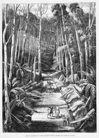
Work on paper (item) - Print of wood engraving, Ebenezer and David Syme, Road Making on the Black Spur, Road to Wood's Point, 1867
A copy of an early wood engraving of the construction of the road over the Black Spur in Victoria.A copy of an early wood engraving of the construction of the road over the Black Spur in Victoria. The Black Spur is known to be one of Victoria's most scenic drives. The road winds through a majestic forest of trees and tree ferns from Healesville to Narbethong and is part of the Maroondah Highway.black spur, wood's point, narbethong, maroondah highway, victoria, wood engraving -
 Marysville & District Historical Society
Document (Item) - Newspaper article, The Argus, New Tourist Road. Marysville to Wood's Point Magnificent Forest Scenery, 02-1924
A newspaper article regarding the opening of the Marysville-Wood's Point Road in February 1924.A newspaper article regarding the opening of the Marysville-Wood's Point Road in February 1924. The Marysville-Woods Point Road was originally part of the Yarra Track, constructed in the early 1860s to provide access between Healesville and the Woods Point Goldfields. Despite the steep terrain and engineering difficulties, the Yarra Track soon became a busy route used by pack horses, horse-drawn drays, and wagons. Today this sealed mountain road is a popular scenic drive between Marysville and Warburton.marysville-wood's point road, yarra track, healesville, wood's point goldfields, warburton, the argus -
 Eltham District Historical Society Inc
Slide - Photograph, Eltham-Yarra Glen Road, Kangaroo Ground, c.May 1988
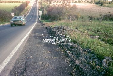
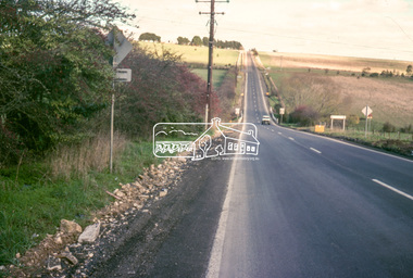
... roads ...Looking south along Eltham-Yarra Glen Road towards intersection with Kangaroo Ground-Warrandyte Road, Kangaroo Ground, May 198835mm colour positive transparency (1 of 36) Mount - Kodak KodachromeProcess Date MAY 88Minfrastructure, roads, eltham-yarra glen road, kangaroo ground, kangaroo ground-warrandyte road -
 Eltham District Historical Society Inc
Slide - Photograph, Eltham-Yarra Glen Road, Kangaroo Ground, c.May 1988
... roads ...Looking south along Eltham-Yarra Glen Road towards intersection with Kangaroo Ground-Warrandyte Road, Kangaroo Ground, May 198835mm colour positive transparency (1 of 36) Mount - Kodak KodachromeProcess Date MAY 88Minfrastructure, roads, eltham-yarra glen road, kangaroo ground, kangaroo ground-warrandyte road -
 Greensborough Historical Society
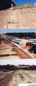
Photographs, Gary Partington, Greensborough By-Pass, 1986_
... roads ...The Greensborough by-pass extends from Grimshaw Street in the south to Diamond Creek Road in the north. It is intersected by the eastern end of the Metropolitan Ring Road.Unpublished photographs of the construction of the Greensborough by-pass.21 colour photographs of the construction phase of the Greensborough By-pass.greensborough bypass, roads, greensborough, gary partington, metropolitan ring road -
 Melbourne Legacy
Photograph, Harelands, 9/9/1963
The Harelands property in Kew, was used as a residence for Junior Legatees (Legacy Beneficaries) up to the age of 14 years. It operated during the 1960’s and 1970’s.Melbourne Legacy established residences to aid children of deceased servicemen complete their education, take further education and find employment.Black and white photo of Harelands, Willsmere Road, Kew. Handwritten 'Harelands 1963 Willsmere Road, Kew up to 14 year-olds Residence for Junior Legatees'. Stamped 'Property of Melbourne Legacy' in purple ink. Stamped with photographers details and order number (P2976/7) and date (9/9/63).harelands, residences, properties -
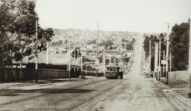 Melbourne Tram Museum
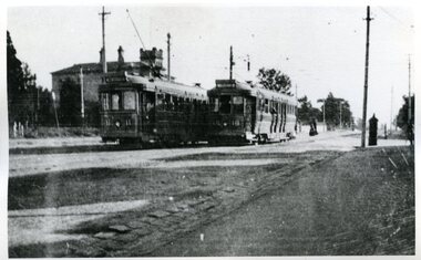
Photograph - Black and white - Whitehorse Road, Balwyn c1920's
Shows B class tram number 90, east bound in Whitehorse Road, at the intersection with Burke Road. Photo has a caption "Whitehorse Road Balwyn c1920s". Tram has the PMTT style destination board. There are a number of people standing on the right hand side of the tram. Note the shelter on the left hand side. This shelter remains in same position (2022). Tram No. 90, was built by James Moore during 1917-1918 and was sold to the Electric Supply Co of Victoria in 1931 and became Bendigo No 7.Yields information about the location, the landscape and the trams in use at the time.Black and white photograph of an outbound tram in Whitehorse Road c1920s, looking east.tramways, balwyn, whitehorse road, tram 90, shelters, pmtt, james moore, b class -
 Whitehorse Historical Society Inc.
Photograph, Vermont Primary School
The Vermont Primary School No.1022 began operating in 1882. By 1958 a new school was built in Nurlendi Road, Vermont. After standing derelict for many years, the school was moved to the Nurlendi Road site in 1992Coloured photograph of a section of the original Vermont Primary School building, now on the Nurlendi Road sitevermont primary school no. 1022, schools -
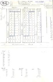 Ringwood and District Historical Society
Plan, Plan of Subdivision No.11498 with handwritten costing notations - East Ringwood Central Estate c.1948
Two handwritten pages showing layout of Subdivision no 11498 with surveyor notations including property sizes and road construction cost calculations. Drainage easement 6 feet wide shaded blue.Plan of Subdivision No. 11498, Part of Crown Allotment 27, Parish of Ringwood, County of Mornington, (Certificate of Title Vol 5120 Fol 1023945). Owner Mr Vogel. Subdivision includes Knaith Road, Northwood Street, Langley Street, Bondi Street, and Government Road (later Alexandra Road), Ringwood East. G. Parsons & Sons, Licensed Surveyors, 389 Flinders Lane (Melbourne). -
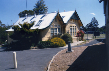
 Whitehorse Historical Society Inc.
Photograph, Former Shire Offices, 1973
Later used as Offices by Country Roads BoardBlack and white photo of Municipal Office for the Shire of Blackburn and Mitcham, 360 Whitehorse Road, Nunawading. Later the City of Nunawading. - Sold to the Country Roads Board (C.R.B.), later known as Vicroads until sold in mid 1990s. Photo taken in 1973.shire of blackburn and mitcham chambers, victoria. country roads board, vicroads, whitehorse road, nunawading, no 360 -
 Melbourne Tram Museum
Photograph - Black and White - HTT trams 11 and 18 Riversdale Road Hawthorn
Photo shows two of the Hawthorn Tramways Trust bogie trams 11 and 18 in Riversdale Road at the intersection with Glenferrie Road, c1916 or later. Tram 11 later became MMTB 117 and then SEC Ballarat 37. Tram 18 became MMTB 124 and then Ballarat 35. Note the letterbox on the right.Yields information about the HTT bogie trams.Photograph - Black and White - HTT trams 11 and 18 Riversdale Road Hawthorntramways, trams, htt, hawthorn tramways trust, tram 11, tram 18, riversdale road, n class -
 Eltham District Historical Society Inc
Slide, Looking westerly into Martins property, Lower Plenty, 18 July 1972, 1972
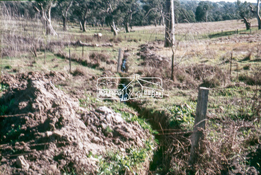
Water drainage work undertaken by Eltham Shire Council in Bonds Road, Lower Plenty outside the Martin property opposite Montpelier Drive, July 1972 Note natural gully conditions and open drain cleared through property with owner's consent.35 mm colour positive transparency Mount - Agfacolor Service (Blue)Bonds Road (Martin property) 12.10 pm 18.7.72bonds road, drainage works, eltham shire council, infrastructure, lower plenty, martin property, montpelier drive -
 Melbourne Tram Museum
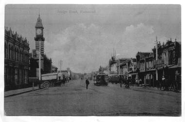
Photograph - Enlargement of a postcard, Bridge Road Richmond, c1900
The first image shows the shops on either side of Bridge Road with horse drawn carts and one cable tram. The second image from the Town Hall tower, shows two cable tram sets, the narrowing of the road. Has in the view Guddon & Selleck Auction House and Property Exchange also advertising Commercial Union Assurance Co. and George Stirling and Sons store.Yields information about Bridge Road, c1900Set of two A3 enlargements of postcards 1 - Looking east along Bridge Road from near Church St 2 - Bridge Road Richmond - from Town Hall looking westcable trams, tramways, richmond, bridge road, -
 Kew Historical Society Inc
Photograph - Y1 Class 611 in Barkers Road and High Street South, 1990
This colour photograph, with 15 others are enlargements gifted to the Society by Mel Lawrence in 2016. They were taken at a commemorative event from the Kew Tram Depot. Laminated colour enlargement of Y1 Class 611, on the corner of Barkers Road and High Street South, during a re-enactment from the Kew Depot in 1990.Annotation reverse: "Kew Depot 1990. Y1 Class 611, turning out of Barkers Road into High Street South"kew tram depot, trams -- melbourne, y1 class trams -
 Whitehorse Historical Society Inc.
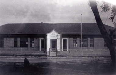
Photograph, Opening of the Mitcham State School No. 2904
The original Mitcham State School was built in 1888 and was closer to Mitcham Road, Whitehorse Road intersection than this 1929 (and present 2005) location. The donor, Helen Driscoll (nee Fitzsimone) was born in 1922 and lived at 20 Haines Street, Mitcham at the time of the opening.Black and white photograph of the opening of the Mitcham State School No 2904, Mitcham Road in 1929mitcham state school no. 2904 -
 Orbost & District Historical Society
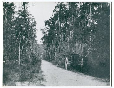
black and white photograph, 1913
This photograph shows the regrowth of vegetation on the road between Genoa and the border - now the Princes Highway.This is a pictorial record of the main road from Orbost to the New South border, The Princes Highway, in the early 20th century.A large black / white photograph of a bush road wwith a vehicle and a man on the side of it.on back - " Princes Highway showing the regrowth.....1913"princes-highway-genoa transport -
 Whitehorse Historical Society Inc.
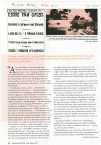
Article, Electric Tram Capsizes, 1917
In 1917, a tram capsized in Norwood (Toorak Road) after gathering too much speed which resulted in the death of a boy and injuries to 18 passengers.norwood road, burwood, toorak road, camberwell, tram services, trams -
Whitehorse Historical Society Inc.
Map, Proposed shared path network, 2001
Draft plans of proposed shared path networkDraft plans of proposed shared path network for Eastern Freeway Extension, Springvale Road to Ringwood.Draft plans of proposed shared path network plans, eastern freeway extension, city of whitehorse, vicroads, city of maroondah, vicroads bicycle coordinator, footpaths, bicycle paths -
 Ringwood and District Historical Society
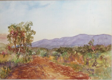
Painting, Winifred Miles, "Mullum Road" (Ringwood) - Water colour on paper by Winifred Miles (1884-1944), Undated, later than 1910
"Alexander Colquhoun [Herald art critic 1914-1922 and feature writer for the Age 1926-1941] ... took private students in the first decade of the century, and one of these was Winifred Miles, who after her marriage in 1910 lived the remainder of her life in Ringwood. ... (She) began by doing charcoal studies of animals when she was in Balranald, but in later years moved to oils and then watercolours, travelling around Ringwood to find places to paint by means of a pony-driven governess-cart. She won prizes for paintings in the Royal Melbourne Shows." - Hugh Anderson - Ringwood, Place of Many Eagles [p.217].Painting with cardboard border in glass-fronted frame. One of two undated paintings by Winifred Miles' viewed from the same vantage point on Mullum Mullum Road in Ringwood. (See Registration Number 4848)Sticker on back of frame - "Ringwood Framing Gallery, 233 Whitehorse Road Ringwood, Phone 8704930" -
 Ringwood and District Historical Society
Painting, Winifred Miles, "Mullum Road" (Ringwood) - Water colour on paper by Winifred Miles (1884-1944), Undated, later than 1910
"Alexander Colquhoun [Herald art critic 1914-1922 and feature writer for the Age 1926-1941] ... took private students in the first decade of the century, and one of these was Winifred Miles, who after her marriage in 1910 lived the remainder of her life in Ringwood. ... (She) began by doing charcoal studies of animals when she was in Balranald, but in later years moved to oils and then watercolours, travelling around Ringwood to find places to paint by means of a pony-driven governess-cart. She won prizes for paintings in the Royal Melbourne Shows." - Hugh Anderson - Ringwood, Place of Many Eagles [p.217].Painting with cardboard border in glass-fronted frame. One of two undated paintings by Winifred Miles' viewed from the same vantage point on Mullum Mullum Road in Ringwood. (See Registration Number 4847)Sticker on back of frame - "Ringwood Framing Gallery, 233 Whitehorse Road Ringwood, Phone 8704930" -
 Kew Historical Society Inc
Photograph - Flooding of the Yarra River in North Kew, 1934
North Kew, now divided between Kew and Kew East, bordered the Yarra River. As such, it was a region subject to flooding in the Yarra Valley. Development beyond this point (ie Kellett Grove) was limited by the City of Kew's planning regulations. Prior to urban development, the area since European settlement and the first land sales in the district in the 1840s, had been used for dairy farming. Small sepia snapshot of floodwaters taken from near Willsmere Road, in what was then known as North Kew. The point of view is looking towards Fairfield. In the foreground are two figures viewing a group in a rowboat in the middle of the flooded river. Semi-submerged street lighting indicates that entire streets had been. overwhelmed by the flood waters. Verso: WILLSMERE ROAD NORTH KEW / Stamped 3 163yarra river -- north kew, floods -- yarra valley, floods -- north kew, floods -- 1934, natural disasters -- kew, willsmere road -
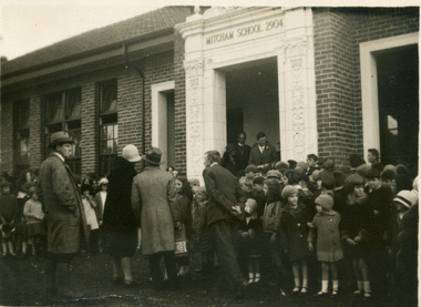 Whitehorse Historical Society Inc.
Photograph, Opening of the Mitcham State School No. 2904, 1929
The original Mitcham State School was built in 1888 and was much closer to the Mitcham Road-Whitehorse Road intersection than the 1929 (and present 2005) location. The donor, Helen Driscoll (nee Fitzsimone) was born in 1922 and lived at 20 Haines Street, Mitcham at the time of the openingBlack and white photograph of the opening of the Mitcham State School No 2904, Mitcham Road in 1929mitcham state school no. 2904 -
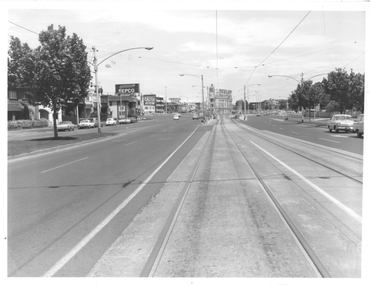 Melbourne Tram Museum
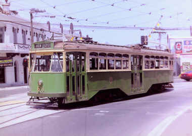
Photograph - St Kilda Road looking south, Melbourne & Metropolitan Tramways Board (MMTB), c1975
Photograph of the south end of St Kilda Road, before the full reconstruction of High Street St Kilda (now St Kilda Road) but after the reconstruction of the Queens Road underpass, photo c1975. Shows the buildings at the junction including the Tower Hotel in the distance. Signs for advertising include Repco, Caltex Astron, UniRoyal Tyres, and Dunlop Tyres. The "Timeline history of Melbourne Tramways etc Barry George et al" gives the date of the opening of the High St section as March 1975.Yields information about the redevelopment of St Kilda Junction.Black and White Photograph with notes on the rear.On rear of photograph in ink "St Kilda Road Junction Stage One complete c1975"trams, tramways, high st, st kilda junction, st kilda rd -
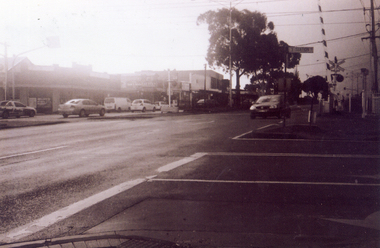
 Whitehorse Historical Society Inc.
Photograph, The Railway Crossing from Station Street, 1/06/2009
One of a collection of photographs taken of the Nunawading Railway Station prior to the lowering of the railway line and building of the new railway station on the western side of Springvale Road so that the Springvale Road Rail Crossing can be eliminated.Black & white photograph of he precinct surrounding the Nunawading Station and the Springvale Road Railway crossing. This photograph is of the crossing from Station Street. The liquor on the corner of Springvale Road and Oval way is in the background. See NP 3545 to NP3567 for the complete set of photographsnunawading railway station, springvale road nunawading, redevelopment of railway line/springvale road., oval way nunawading -
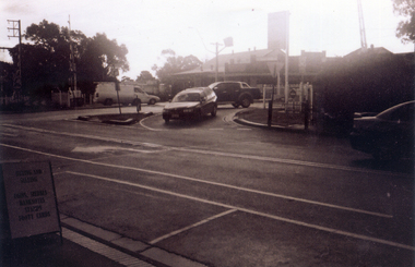
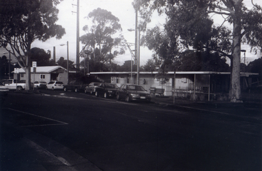
 Whitehorse Historical Society Inc.
Photograph, Service Station -Now Works Site Office, 1/06/2009
One of a collection of photographs taken of the Nunawading Railway Station prior to the lowering of the railway line and building of the new railway station on the western side of Springvale Road so that the Springvale Road Rail Crossing can be eliminated.Black & white photograph of he precinct surrounding the Nunawading Station and the Springvale Road Railway crossing. This photograph is former Service Station on west side of Springvale Road. Now works site office. See NP 3545 to NP3567 for the complete set of photographsnunawading railway station, springvale road nunawading, redevelopment of railway line/springvale road. -
 Whitehorse Historical Society Inc.
Photograph, General View of Nunawading Station, 1/06/2009
One of a collection of photographs taken of the Nunawading Railway Station prior to the lowering of the railway line and building of the new railway station on the western side of Springvale Road so that the Springvale Road Rail Crossing can be eliminated.Black & white photograph of he precinct surrounding the Nunawading Station and the Springvale Road Railway crossing. This photograph is view of the Nunawading Railway Station from Walker Road, showing the North an South Platforms. See NP 3545 to NP3567 for the complete set of photographsnunawading railway station, springvale road nunawading, redevelopment of railway line/springvale road., walkers road nunawading