Showing 7074 items
matching significance
-
 Eltham District Historical Society Inc
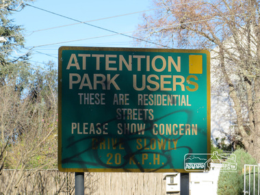
Photograph, Liz Pidgeon, Heritage Excursion; Eltham Lower Park Walk and Talk, 1 July 2017, 1 July 2017
Street signage: Attention park users these are residential streets please show concern drive slowly 20 m.p.h with graffiti Newsletter No., 234, June 2017 Heritage Excursion - Saturday 1st July - Eltham Lower Park - Walk and Talk Eltham Lower Park has played an important part in the history of our area since the early days of European settlement when it was used by local residents as an informal racecourse. Prior to that its location at the junction of the Diamond Creek and the Yarra River made it an important meeting place for the Wurundjeri people. The park combines formal elements and sporting facilities with remnant bushland that is of environmental significance. It is home to sporting and horse riding clubs, popular play spaces and the Diamond Valley Miniature Railway, which attracts large numbers of visitors. The park will be the venue for our July excursion which will comprise a walk of about 3.5 km around the park and adjacent areas. Along the way we will discuss the history and natural history of the area. The path along the creek and the river provides a pleasant and scenic walk. This walk on Saturday 1st July is about 3.5 km in length and will take 2 to 2.5 hours. It will start at 2pm at the Main Road car park at the front of the park. (Melway ref 21 H 10). Born Digitalheritage excursion, activities, eltham district historical society, eltham lower park, sign, grafitti -
 Eltham District Historical Society Inc
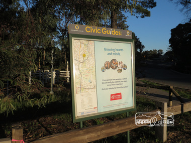
Photograph, Liz Pidgeon, Heritage Excursion; Eltham Lower Park Walk and Talk, 1 July 2017, 1 July 2017
Civic Guide sign near the entrance of Eltham Lower Park with a map of the local area and an advertisement for Eltham College Newsletter No., 234, June 2017 Heritage Excursion - Saturday 1st July - Eltham Lower Park - Walk and Talk Eltham Lower Park has played an important part in the history of our area since the early days of European settlement when it was used by local residents as an informal racecourse. Prior to that its location at the junction of the Diamond Creek and the Yarra River made it an important meeting place for the Wurundjeri people. The park combines formal elements and sporting facilities with remnant bushland that is of environmental significance. It is home to sporting and horse riding clubs, popular play spaces and the Diamond Valley Miniature Railway, which attracts large numbers of visitors. The park will be the venue for our July excursion which will comprise a walk of about 3.5 km around the park and adjacent areas. Along the way we will discuss the history and natural history of the area. The path along the creek and the river provides a pleasant and scenic walk. This walk on Saturday 1st July is about 3.5 km in length and will take 2 to 2.5 hours. It will start at 2pm at the Main Road car park at the front of the park. (Melway ref 21 H 10). Born Digitalheritage excursion, activities, eltham district historical society, eltham lower park, civic guide, eltham college, sign -
 Eltham District Historical Society Inc
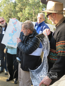
Photograph, Liz Pidgeon, Heritage Excursion; Eltham Lower Park Walk and Talk, 1 July 2017, 1 July 2017
Local Historian Russell Yeoman and EDHS President Jim Connor with a map and aerial photograph of the area the heritage walk will cover. Newsletter No., 234, June 2017 Heritage Excursion - Saturday 1st July - Eltham Lower Park - Walk and Talk Eltham Lower Park has played an important part in the history of our area since the early days of European settlement when it was used by local residents as an informal racecourse. Prior to that its location at the junction of the Diamond Creek and the Yarra River made it an important meeting place for the Wurundjeri people. The park combines formal elements and sporting facilities with remnant bushland that is of environmental significance. It is home to sporting and horse riding clubs, popular play spaces and the Diamond Valley Miniature Railway, which attracts large numbers of visitors. The park will be the venue for our July excursion which will comprise a walk of about 3.5 km around the park and adjacent areas. Along the way we will discuss the history and natural history of the area. The path along the creek and the river provides a pleasant and scenic walk. This walk on Saturday 1st July is about 3.5 km in length and will take 2 to 2.5 hours. It will start at 2pm at the Main Road car park at the front of the park. (Melway ref 21 H 10). Born Digitalheritage excursion, activities, eltham district historical society, eltham lower park, russell yeoman, jim connor, guide -
 Glen Eira Historical Society
Document - CAULFIELD RSL
This file contains two items pertaining to the property housing the Caulfield RSL: 1/A photocopy (2 pages) of an assessment of the property, dated 01/1997, by Andrew Ward, for purposes of ascertaining its historical significance. The assessment describes the architectural features of the property, offers a brief history of it, specifies why it should be considered significant, and recommends that it be added to the National Estate Register. Included is a black-and-white photograph of the exterior of the building. 2/An assessment (17 long pages plus appendix) of the car parking issues procured as a result of the decision to refurbish the Caulfield RSL. Prepared by Grogan Richards Pty Ltd, dated 13/11/2002, reviewed by Joanna Gauetty, and authorised by Rody Jude. Included is a description of the Club’s location and surrounding motorways as they existed at the time, a description of the Club itself (eg its opening hours and rate of patronage as per each opening hour), occupancy surveys, descriptions of other recent car parking construction within the same area, a description of the extensions the RSL is aiming to construct, and descriptions of the considerations any new construction must take into account. Included is a black-and-white map of Caulfield noting the RSL’s location, and two black-and-white photographs showing the view to the north and south of St. George’s Road, respectively.caulfield, caulfield returned servicemen league (rsl), exservice organisations, clubs and associations, ward andrew, glen eira heritage management plan, historic buildings, architectural, styles, national trust company, st. leonard’s, elsternwick club, grogan richards pty ltd, returned servicepeople, armed forces, soldiers, aged people, senior citizens centres, st. george’s road, elsternwick, english domestic revival style, moderne style, brick houses, bay windows, architectural features, prendergast ellen mrs., ford grylis, dl design group, gauetty joanna, jude rody, parking, glen eira planning scheme -
 Ballarat Heritage Services
Photograph - Image - Colour, Clare Gervasoni, Bishop's Palace Ballarat Featuring Chimneys and Roof Line, Ballarat, 2014, 23/02/2014
Bishops Palace was built in 1877 as the home for the first Catholic Bishop of Ballarat. Designed by Melbourne architect, Joseph Reed, of Reed and Barnes, it was built by George Broom at a cost of £6,000. Reed and Barnes also designed Melbourne’s State Library, Ripponlea Estate and the Melbourne Royal Exhibition Building. The original heritage-listed gold lead stencilled paintwork that can be seen in the front entry and on the staircase walls at Bishops Palace was replicated in the Royal Exhibition Building. The original property was 140 squares set on 11 acres of gardens and took up an entire block of Sturt Street. This was on scale with the importance of Ballarat as a gold-mining centre at the time. Bishop's Palace is of architectural, aesthetic and historical significance to the State of Victoria. The two-storey bluestone mansion is an impressive example of 19th-century Gothic architecture with an unusual design. It retains many of its original features, including lead stencilled paintwork, cornices, ceiling roses, fixtures and fittings. Since sold by the Catholic Church the Bishops Palace has undergone a number of transformations in its lifetime, from the home of the first Bishop to a private residence, and today, as a luxurious accommodation, wedding and events venue. The grounds were subdivided over the years, and the property is now surrounded by four of the original 11 acres of gardens. It opened its doors to the public in 2019.Colour image of the bluestone Bishop's Palace, and it's cast iron lace.architecture, garden, bishop's palace, cast iron lace, cast iron, catholic church -
 Eltham District Historical Society Inc
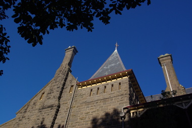
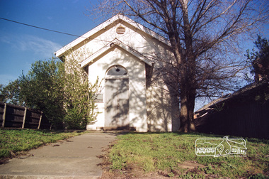
Photograph - Digital Photograph, Alan King, St Margaret's Anglican Church, Pitt Street, Eltham, 30 January 2008
St Margaret’s Church of England was officially opened on December 12, 1861. It is the oldest intact church building in Eltham. At the time it was known as Christ Church until its consecration in 1871, when it was completely free of debt (£1,700 for the church and parsonage) despite the district’s poverty. This was largely due to the free labour and materials, including locally made bricks donated by local artisans and others. The church is historically significant because it is the oldest church in the former Shire of Eltham and has associations with the philanthropist and founder of Brighton, Henry Dendy (who donated the land on which the church is built), the architect Nathaniel Billing and the prominent local builder, George Stebbing. The church is architecturally and aesthetically significant because it is constructed in the Gothic Revival style with several stained-glass windows of various dates and is also a very early use of polychromatic brickwork in Victoria. Billing was one of the first Melbourne architects to employ polychromatic brickwork and an important early architect. The rear wall was intended to be temporary. A major feature of the design is the large buttresses with long, steeply graded upper faces. The overall design is well proportioned with the surface brick patterns relieving an otherwise austere design. The church is spiritually and socially significant because it has been an important place of worship for the people of Eltham for almost 150 years. The land on which the buildings stand was donated by Henry Dendy. Dendy arrived in Melbourne in 1841 after purchasing in England eight square miles at Brighton under the system of "special surveys". After this land passed out of his hands, Dendy moved about Victoria, visited England, then returned to settle in Eltham where he purchased a flour mill. Dendy chaired the meeting held in 1860 “for the purpose of devising such means as may be expedient for the establishment of a Church of England in the township of Eltham”. He became chairman and treasurer of the church committee. Unlike the establishment of many early churches in Victoria where a vicar was appointed to a parish and later a permanent church was constructed, the population at Eltham initiated action to build a church. The nearest church at that time was at Heidelberg and the Eltham settlement was part of the parish of St Johns Heidelberg. Isolation and the tedious, time consuming journey between Heidelberg and Eltham resulted in the Eltham community taking its own action. The original vicarage (Dendy House) at the rear of the church is also an important part of the cultural significance of this place because it is connected to the church and the development of the Eltham area. Together, the church and the vicarage are aesthetically significant because they form a significant streetscape feature. The mud-brick community hall designed by Robert Marshall was added in 1978. In 2014 the original temporary rear wall was removed as part of a modern extension designed by Architects Atelier Wagner and constructed by Conrad Construction and Management. Covered under Heritage Overlay, Nillumbik Planning Scheme. National Trust of Australia (Victoria) State significance Victorian Heritage Published: Nillumbik Now and Then / Marguerite Marshall 2008; photographs Alan King with Marguerite Marshall.; p67This collection of almost 130 photos about places and people within the Shire of Nillumbik, an urban and rural municipality in Melbourne's north, contributes to an understanding of the history of the Shire. Published in 2008 immediately prior to the Black Saturday bushfires of February 7, 2009, it documents sites that were impacted, and in some cases destroyed by the fires. It includes photographs taken especially for the publication, creating a unique time capsule representing the Shire in the early 21st century. It remains the most recent comprehenesive publication devoted to the Shire's history connecting local residents to the past. nillumbik now and then (marshall-king) collection, eltham, st margaret's anglican church, st margaret's church, christ church -
 Eltham District Historical Society Inc
Photograph - Digital Photograph, Marguerite Marshall, Parish Hall, St John's Anglican Church, Diamond Creek, 7 September 2008
The building was designed by Charles Maplestone of Heidelberg, son-in-law to Anthony Beale of St Helena. Maplestone was a prominent architect who came out to Australia with his family in 1852. The foundation stone was laid by Mrs Isabella Maplestone on 11th November 1867. The bricklayers for the church were George Stebbing, H Limmer, H Spicer and a Mr Timm while Thomas Day was the stonemason. Another three years were to pass before sufficient money could be raised for its completion. It was opened by Bishop Perry on 1st November, 1870. The church bell which hung under a tree for 50 years until it was incorporated in the parish hall was brought out from England and presented by Charles Orme. In 1916, the estate of George Martin Pizzey left sufficient money to build the red brick hall, which still stands today (2023) though in January 1969 the hall and bell tower were badly damaged by bushfire. Coincidentally the former home of benefactor, George Pizzey was destroyed in the same fire. Of particular significance are the interior and exterior of the church, the Sunday school and hall with emphasis on pre-World War I fabric (excluding the 1990s additions) and the three coloured glass windows currently suspended in the 1990s entry foyer. In 2011 further alterations were made to the front of the Church. The church is historically significant because it was the oldest public building in the former Diamond Valley Shire, is amongst the oldest buildings in the Shire of Nillumbik and is associated with the early settlement of the Diamond Creek district. The church is historically, socially and spiritually significant because it has been a place of worship for over 150 years and continues to be, an important meeting place in the Shire. The church is aesthetically significant for the three stained glass windows executed by the noted stained glass manufacturers, Ferguson & Urie, as well as the supporting coloured glass windows in the church. The Sunday school & parish hall is architecturally significant because the hall is a well executed and preserved example of the work of noted church architects, North & Williams. It is historically significant because it is connected with local parishioner and Melbourne industrialist, George Pizzey, who bequeathed funds for its construction. Covered under Heritage Overlay, Nillumbik Planning Scheme. National Estate Ntionl Trust of Australia (Victoria) Local significance Published: Nillumbik Now and Then / Marguerite Marshall 2008; photographs Alan King with Marguerite Marshall.; p85 References: St Johns Anglican Church complex, Sunday School and Parish Hall 61 Main Street DIAMOND CREEK, NILLUMBIK SHIRE. (2023, June 7). Retrieved from https://vhd.heritagecouncil.vic.gov.au/places/64023 Diamond Creek, VIC. – St John’s Anglican (2023, June 7). Retrieved from https://www.churchhistories.net.au/church-catalog/diamond-creek-vic-st-johns-anglican This collection of almost 130 photos about places and people within the Shire of Nillumbik, an urban and rural municipality in Melbourne's north, contributes to an understanding of the history of the Shire. Published in 2008 immediately prior to the Black Saturday bushfires of February 7, 2009, it documents sites that were impacted, and in some cases destroyed by the fires. It includes photographs taken especially for the publication, creating a unique time capsule representing the Shire in the early 21st century. It remains the most recent comprehenesive publication devoted to the Shire's history connecting local residents to the past. nillumbik now and then (marshall-king) collection, st john's anglican church, diamond creek, parish hall -
 The Beechworth Burke Museum
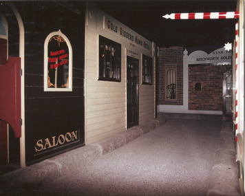
Photograph, c1990
Taken in the 1990's, this photograph depicts a row of shop fronts in the 'Street of Shops' exhibition in the Burke Museum in Beechworth. This exhibition was created and opened in 1979 and was intended to reflect and imitate a historic peirod in the town's past. The time period decpicted is that of the Gold Rush which swept through many Victorian towns from the 1850's onwards. For the town of Beechworth, the gold rush began in 1852, when gold was discovered in Spring Creek, drawing in many new residents seeking to make a fortune and transforming a once remote town into a bustling centre brimming with hope and opportunity. By 1857, the town contained over 200,000 residents and with this, the need for more amenities and intsitutions arose. Multiple churches, banks, schools, shops, hospitals and other essential buildings appearing over the years. The wealth acquired through the gold rush is largely responsible for the vast development of the town and many of its significant buildings which still remain to this day. This photograph also highlights the significance of this type of exhibition, providing a new mode of experiencing and learning about the past. The street depicts the many supporting trades and industries that arose from the mass migration during the gold rush. The creation of the Street of Shops in 1979 was envisioned by Roy Harvey who was the curator at the time, with the intention of recreating an authentic feel to the environment while collecting from the community to accurately portray the multiculturalism that is ingrainded in many towns and communities of Victoria. This photograph contains historical significance as it relates to and portrays an especially important period of time within Beechworth and Victoria's history. The gold rush phenomena ushered in a wave of hope and prosperity for citizens and immigrants alike. It provided many with the opportunity to strike it rich, while the town prospered and grew in many ways. This widespread development that accompanied the gold rush occured throughout Victoria and holds great historical importance when recording the social, economic and communal developments that occured throughout the time period which gave way to the beloved towns and communities we know today. Beechworth itself is acknowledged as Victoria's best-preserved gold mining town and deserves recognition of its significance. it also showcases the great significance of social develpment and globalization that occured throughout the state during this period. Coloured rectangular photograph printed on matte photographic paper and unmounted. Obverse: Dancing every night 8pm-6am [mirror] / Gold Diggers Arms Hotel façade / Star / Beechworth Gold / J. Davidson / Saloon Reverse: 3306 beechworth, burke museum, street of shops, gold rush, indigo shire gold rush, 1850s beechworth, burke museum exhibitions, saloon, gold buyer, hotel, historical streetscape, gold rush immigration -
Glen Eira Historical Society
Article - Rosemont, Kooyong Road, 112A, Caulfield North
Eight items about this property: Handwritten notes from 1870 Caulfield rate book along with list of owners 1870-1890; unsigned and undated. Short history of Rosemont from 1860’s with owners listed up to 1895. Includes description of land and architectural features of house with sketch of pillar. Unsigned and undated with both typed and handwritten information. Unsigned and undated note (original and photocopy) about 112 Kooyong Road and Rosemont’s changing address over time. Photocopy of Andrew Ward’s Heritage Study (two pages) on 112 Kooyong Road (rear) describing significance, history and description of property. Includes photo. Online print without photo of same Heritage Study with handwritten note about brick exterior provided by owner/occupier to compiler Andrew Frederick 2010. Excerpt from Caulfield’s Building Heritage p.47-48 Volume 1 by Dr. Geulah Solomon about Rosemont giving description and history (start of entry on page 46 omitted). Added by Claire Barton date unknown. Notes taken by Andrew Frederick from Caulfield Heritage Vol.1 pages 47-9 re history; and from Sands and McDougall Directories of 1874, 1903, 1911, 1913 and 1923; plus 1913 entry in Vict. P.O Directory. These show house numbers and owners for those periods. Three pages of plans relating to Rosemont covering ground and first floors.rosemont, caulfield north, howitt godfrey dr., kooyong road, blake arthur, grice james, cast iron work, cellars, campbell john a., campbell john archibald, stables, verandahs, king thomas, howitt’s corner, howitt alfred william, farm houses, bakewell john, architectural features, bricks, mcwilliams robert, rosemont estate, mansions, howitt william godfrey dr., arches, balaclava road, coach houses, outbuildings, timber houses, squatters, campbell john, connelly mrs., king florence, slate tiles, ward andrew, chimneys, fireplaces, allen george, warburton james, mirfield professor, hall william sir, hall lady, land subdivision, cellars, embossed leather features, bay windows, house names, victorian style, ceilings, stairs, gardens -
 Eltham District Historical Society Inc
Photograph, Doug Orford, Eltham Courthouse, 730 Main Road, Eltham, 1985, 1985
This building is a fine example of a very early small brick country court house which retains its furnishings and has important associations with the early history of the Eltham township. It was used for Eltham Road Board meetings in the 1860s and later to provide additional school accommodation. It is the oldest public building remaining in Eltham and forms an important group in historic and streetscape terms with the adjoining former police residence. The survival of the furnishings (of unknown origins) is of particular significance given the building's age. This building, and the former police residence beside it, were constructed as a result of a petition by five Eltham residents in 1857. The nearest police were at Heidelberg eight miles away or at the Caledonia Diggings 21 miles away. After the construction of the Court of Petty Sessions at Eltham in 1859-60 (which was designed by the Public Works Department and built by a Mr Duncan for a cost of 536 pounds), it was used for a variety of purposes. Eltham Road Board meetings were held there until 1868 when the board was transferred to Kangaroo Ground and as the Road Board Secretary's office, until this was transferred to Wingrove Cottage in 1867. It was used as an overflow for the Dalton Street School in 1875. According to National Trust records, the Eltham Court House is a relatively rare building type. There are only six other known examples of similar small brick country court houses in the state which have small projecting entry porches and a gabled form. Roll of 35mm colour negative film, 7 stripsFuji 100Neltham, eltham courthouse, main road -
 Eltham District Historical Society Inc
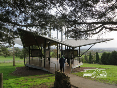
Photograph, Liz Pidgeon, Moor-Rul Viewing Platform, 10 August 2016
The Moor-Rul Viewing Platform, part of the Kangaroo Ground War Memorial Park opened in April 2007. Eight double-sided interpretation panels on the Moor-rul viewing platform highlight the area's Aboriginal and European history of the area and also details of local geology, flora and fauna. These panels feature high quality graphic design and professionally written text. The subjects covered are: ''Womin Je Ka" Welcome The Kulin Nation Singing, Dancing, Ceremony, Celebration This Country, My Home The Highland Taken Auld Lang Syne "Same Land Different Views" Working the Land Food from the Earth or "Earth's Harvest" Lest We Forget, "And with the going down of the Sun .... (3 panels) This Black Earth Those other indigenous inhabitants - Kangaroo Ground's Wildlife Silent Witnesses - Kangaroo Ground's White Manna Gums Belonging A Place of Reverence and A Tower of Strength Souce: EDHS Newsletter No 173 March 2007. As part of a program to acknowledge the Anzac Centenary Nillumbik Shire Council partnered with Yarra Plenty Regional Library to provide a bus tour with commentary of local sites of significance: Shire of Nillumbik World War One Memorials tour, 10 August 2016. These included Eltham township, the Shire of Eltham War Memorial at Kangaroo Ground, Christmas Hills war memorial, Hurstbridge memorial recreation park and finshed at Eltham Library to view the Writing the War exhibtion at Eltham Library Community Gallery.Born Digitalshire of nillumbik, moor-rul viewing platform, kangaroo ground, memorial park -
 Eltham District Historical Society Inc
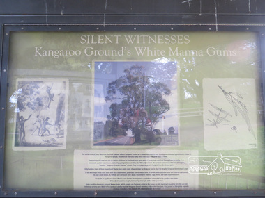
Photograph, Liz Pidgeon, Moor-Rul Viewing Platform Panel: Silent Witnesses Kangarooo Ground's White Manna Gums, 10 August 2016
The Moor-Rul Viewing Platform, part of the Kangaroo Ground War Memorial Park opened in April 2007. Eight double-sided interpretation panels on the Moor-rul viewing platform highlight the area's Aboriginal and European history of the area and also details of local geology, flora and fauna. These panels feature high quality graphic design and professionally written text. The subjects covered are: ''Womin Je Ka" Welcome The Kulin Nation Singing, Dancing, Ceremony, Celebration This Country, My Home The Highland Taken Auld Lang Syne "Same Land Different Views" Working the Land Food from the Earth or "Earth's Harvest" Lest We Forget, "And with the going down of the Sun .... (3 panels) This Black Earth Those other indigenous inhabitants - Kangaroo Ground's Wildlife Silent Witnesses - Kangaroo Ground's White Manna Gums Belonging A Place of Reverence and A Tower of Strength Souce: EDHS Newsletter No 173 March 2007. As part of a program to acknowledge the Anzac Centenary Nillumbik Shire Council partnered with Yarra Plenty Regional Library to provide a bus tour with commentary of local sites of significance: Shire of Nillumbik World War One Memorials tour, 10 August 2016. These included Eltham township, the Shire of Eltham War Memorial at Kangaroo Ground, Christmas Hills war memorial, Hurstbridge memorial recreation park and finshed at Eltham Library to view the Writing the War exhibtion at Eltham Library Community Gallery. Born Digitalshire of nillumbik, moor-rul viewing platform, kangaroo ground, manna gum, display panel -
 Eltham District Historical Society Inc
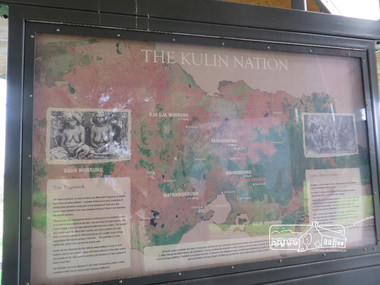
Photograph, Liz Pidgeon, Moor-Rul Viewing Platform Panel: The Kulin Nation, 10 August 2016
The Moor-Rul Viewing Platform, part of the Kangaroo Ground War Memorial Park opened in April 2007. Eight double-sided interpretation panels on the Moor-rul viewing platform highlight the area's Aboriginal and European history of the area and also details of local geology, flora and fauna. These panels feature high quality graphic design and professionally written text. The subjects covered are: ''Womin Je Ka" Welcome The Kulin Nation Singing, Dancing, Ceremony, Celebration This Country, My Home The Highland Taken Auld Lang Syne "Same Land Different Views" Working the Land Food from the Earth or "Earth's Harvest" Lest We Forget, "And with the going down of the Sun .... (3 panels) This Black Earth Those other indigenous inhabitants - Kangaroo Ground's Wildlife Silent Witnesses - Kangaroo Ground's White Manna Gums Belonging A Place of Reverence and A Tower of Strength Souce: EDHS Newsletter No 173 March 2007. As part of a program to acknowledge the Anzac Centenary Nillumbik Shire Council partnered with Yarra Plenty Regional Library to provide a bus tour with commentary of local sites of significance: Shire of Nillumbik World War One Memorials tour, 10 August 2016. These included Eltham township, the Shire of Eltham War Memorial at Kangaroo Ground, Christmas Hills war memorial, Hurstbridge memorial recreation park and finshed at Eltham Library to view the Writing the War exhibtion at Eltham Library Community Gallery. Born Digitalshire of nillumbik, interpretative signage, interpetation panel, indigenous history, moor-rul viewing platform, kangaroo ground -
 Eltham District Historical Society Inc
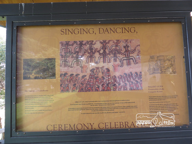
Photograph, Liz Pidgeon, Moor-Rul Viewing Platform Panel: Singing, Dancing, Ceremony, Celebrations, 10 August 2016
The Moor-Rul Viewing Platform, part of the Kangaroo Ground War Memorial Park opened in April 2007. Eight double-sided interpretation panels on the Moor-rul viewing platform highlight the area's Aboriginal and European history of the area and also details of local geology, flora and fauna. These panels feature high quality graphic design and professionally written text. The subjects covered are: ''Womin Je Ka" Welcome The Kulin Nation Singing, Dancing, Ceremony, Celebration This Country, My Home The Highland Taken Auld Lang Syne "Same Land Different Views" Working the Land Food from the Earth or "Earth's Harvest" Lest We Forget, "And with the going down of the Sun .... (3 panels) This Black Earth Those other indigenous inhabitants - Kangaroo Ground's Wildlife Silent Witnesses - Kangaroo Ground's White Manna Gums Belonging A Place of Reverence and A Tower of Strength Souce: EDHS Newsletter No 173 March 2007. As part of a program to acknowledge the Anzac Centenary Nillumbik Shire Council partnered with Yarra Plenty Regional Library to provide a bus tour with commentary of local sites of significance: Shire of Nillumbik World War One Memorials tour, 10 August 2016. These included Eltham township, the Shire of Eltham War Memorial at Kangaroo Ground, Christmas Hills war memorial, Hurstbridge memorial recreation park and finshed at Eltham Library to view the Writing the War exhibtion at Eltham Library Community Gallery.Born Digitalwar memorials, shire of nillumbik, indigenous history, kangaroo ground, moor-rul viewing platform, interpretative signage, interpretation panel, display panel -
 Eltham District Historical Society Inc
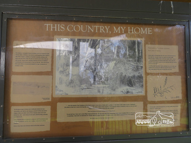
Photograph, Moor-Rul Viewing Platform Panel: This Country, My Home, 10 August 2016
The Moor-Rul Viewing Platform, part of the Kangaroo Ground War Memorial Park opened in April 2007. Eight double-sided interpretation panels on the Moor-rul viewing platform highlight the area's Aboriginal and European history of the area and also details of local geology, flora and fauna. These panels feature high quality graphic design and professionally written text. The subjects covered are: ''Womin Je Ka" Welcome The Kulin Nation Singing, Dancing, Ceremony, Celebration This Country, My Home The Highland Taken Auld Lang Syne "Same Land Different Views" Working the Land Food from the Earth or "Earth's Harvest" Lest We Forget, "And with the going down of the Sun .... (3 panels) This Black Earth Those other indigenous inhabitants - Kangaroo Ground's Wildlife Silent Witnesses - Kangaroo Ground's White Manna Gums Belonging A Place of Reverence and A Tower of Strength Souce: EDHS Newsletter No 173 March 2007. As part of a program to acknowledge the Anzac Centenary Nillumbik Shire Council partnered with Yarra Plenty Regional Library to provide a bus tour with commentary of local sites of significance: Shire of Nillumbik World War One Memorials tour, 10 August 2016. These included Eltham township, the Shire of Eltham War Memorial at Kangaroo Ground, Christmas Hills war memorial, Hurstbridge memorial recreation park and finshed at Eltham Library to view the Writing the War exhibtion at Eltham Library Community Gallery. Born Digitalwar memorials, shire of nillumbik, kangaroo ground, moor-rul viewing platform, interpretative signage, interpretation panel, display panel -
 Eltham District Historical Society Inc
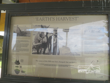
Photograph, Liz Pidgeon, Moor-Rul Viewing Platform Panel: 'Earth's Harvest', 10 August 2016
The Moor-Rul Viewing Platform, part of the Kangaroo Ground War Memorial Park opened in April 2007. Eight double-sided interpretation panels on the Moor-rul viewing platform highlight the area's Aboriginal and European history of the area and also details of local geology, flora and fauna. These panels feature high quality graphic design and professionally written text. The subjects covered are: ''Womin Je Ka" Welcome The Kulin Nation Singing, Dancing, Ceremony, Celebration This Country, My Home The Highland Taken Auld Lang Syne "Same Land Different Views" Working the Land Food from the Earth or "Earth's Harvest" Lest We Forget, "And with the going down of the Sun .... (3 panels) This Black Earth Those other indigenous inhabitants - Kangaroo Ground's Wildlife Silent Witnesses - Kangaroo Ground's White Manna Gums Belonging A Place of Reverence and A Tower of Strength Souce: EDHS Newsletter No 173 March 2007. As part of a program to acknowledge the Anzac Centenary Nillumbik Shire Council partnered with Yarra Plenty Regional Library to provide a bus tour with commentary of local sites of significance: Shire of Nillumbik World War One Memorials tour, 10 August 2016. These included Eltham township, the Shire of Eltham War Memorial at Kangaroo Ground, Christmas Hills war memorial, Hurstbridge memorial recreation park and finshed at Eltham Library to view the Writing the War exhibtion at Eltham Library Community Gallery. Born Digitalwar memorials, shire of nillumbik, kangaroo ground, moor-rul viewing platform, interpretative signage, interpretation panel -
 Eltham District Historical Society Inc
Photograph, Liz Pidgeon, Heritage Excursion; Eltham Lower Park Walk and Talk, 1 July 2017, 1 July 2017
Information board: Hohnes Hill Flora & Fauna Reserve produced by Shire of Nillumbik and Parks Victoria which includes text and images with references to the Eltham Copper Butterfly. Newsletter No., 234, June 2017 Heritage Excursion - Saturday 1st July - Eltham Lower Park - Walk and Talk Eltham Lower Park has played an important part in the history of our area since the early days of European settlement when it was used by local residents as an informal racecourse. Prior to that its location at the junction of the Diamond Creek and the Yarra River made it an important meeting place for the Wurundjeri people. The park combines formal elements and sporting facilities with remnant bushland that is of environmental significance. It is home to sporting and horse riding clubs, popular play spaces and the Diamond Valley Miniature Railway, which attracts large numbers of visitors. The park will be the venue for our July excursion which will comprise a walk of about 3.5 km around the park and adjacent areas. Along the way we will discuss the history and natural history of the area. The path along the creek and the river provides a pleasant and scenic walk. This walk on Saturday 1st July is about 3.5 km in length and will take 2 to 2.5 hours. It will start at 2pm at the Main Road car park at the front of the park. (Melway ref 21 H 10). Born Digitalheritage excursion, activities, eltham district historical society, eltham lower park, hohnes hill, reserve, eltham copper butterfly, sign -
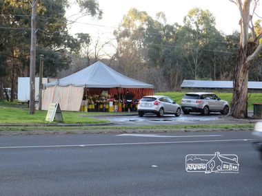 Eltham District Historical Society Inc
Photograph, Liz Pidgeon, Heritage Excursion; Eltham Lower Park Walk and Talk, 1 July 2017, 1 July 2017
Temporary flower vendor set up in a tent opposite Eltham Lower Park. The flower seller sets up on weekends and offers a convenient drive through service for customers. Goolge maps in February 2021 identified this site as Fleur De Feliss Roadside Store. Heritage Excursion - Saturday 1st July - Eltham Lower Park - Walk and Talk Eltham Lower Park has played an important part in the history of our area since the early days of European settlement when it was used by local residents as an informal racecourse. Prior to that its location at the junction of the Diamond Creek and the Yarra River made it an important meeting place for the Wurundjeri people. The park combines formal elements and sporting facilities with remnant bushland that is of environmental significance. It is home to sporting and horse riding clubs, popular play spaces and the Diamond Valley Miniature Railway, which attracts large numbers of visitors. The park will be the venue for our July excursion which will comprise a walk of about 3.5 km around the park and adjacent areas. Along the way we will discuss the history and natural history of the area. The path along the creek and the river provides a pleasant and scenic walk. This walk on Saturday 1st July is about 3.5 km in length and will take 2 to 2.5 hours. It will start at 2pm at the Main Road car park at the front of the park. (Melway ref 21 H 10). Newsletter No., 234, June 2017 Born Digitalheritage excursion, activities, eltham district historical society, eltham lower park, roadside store, flower vendor, fleur de feliss, tent, drive through, drive thru -
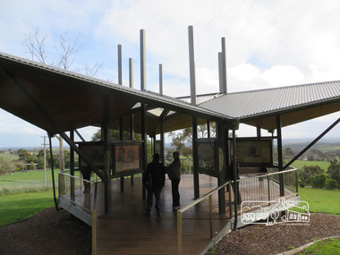 Eltham District Historical Society Inc
Photograph, Liz Pidgeon, Moor-Rul Viewing Platform, 10 August 2016
The Moor-Rul Viewing Platform, part of the Kangaroo Ground War Memorial Park opened in April 2007. Eight double-sided interpretation panels on the Moor-rul viewing platform highlight the area's Aboriginal and European history of the area and also details of local geology, flora and fauna. These panels feature high quality graphic design and professionally written text. The subjects covered are: ''Womin Je Ka" Welcome The Kulin Nation Singing, Dancing, Ceremony, Celebration This Country, My Home The Highland Taken Auld Lang Syne "Same Land Different Views" Working the Land Food from the Earth or "Earth's Harvest" Lest We Forget, "And with the going down of the Sun .... (3 panels) This Black Earth Those other indigenous inhabitants - Kangaroo Ground's Wildlife Silent Witnesses - Kangaroo Ground's White Manna Gums Belonging A Place of Reverence and A Tower of Strength Souce: EDHS Newsletter No 173 March 2007. As part of a program to acknowledge the Anzac Centenary Nillumbik Shire Council partnered with Yarra Plenty Regional Library to provide a bus tour with commentary of local sites of significance: Shire of Nillumbik World War One Memorials tour, 10 August 2016. These included Eltham township, the Shire of Eltham War Memorial at Kangaroo Ground, Christmas Hills war memorial, Hurstbridge memorial recreation park and finshed at Eltham Library to view the Writing the War exhibtion at Eltham Library Community Gallery.Born Digitalshire of nillumbik, moor-rul viewing platform, kangaroo ground -
Federation University Historical Collection
Booklet, Report on the Viability of Establishing a Post Secondary Education Facility Located at the Aradale Traininf Centre, Ararat, Victoria, 1993, 12/1993
Aradale is located 3 km from the centre of Ararat and covers approximately 101 hectares. It consistes of an impresive group of mainly heritage buildings of national significance surrounded by open farmland. Aradale was designed in 1864 in the Victorian Italianate style by John James Clark of the Public Works Department, Victoria. A three storey nurses quarters was built in the 1930s and the Forensic Psychaitry Centre was established in the 1980s. The design of asylums as a specific building type orginated in England in the mddle of the 19th century when it was decided that 'pauper lunatics' would be better cared for in a separate institution rather than being house within the workhouses. Some of the early purpose built asylums were based on the radiating principle of prisons but the arrangement of separat wings at right angles used in hospitals and whorkhouse design soon came to be seen as the most appropriate. The largest 19th century asylum in England was built at Colney Hatch. Kew, Beechworth and Ararat Asylums closely followed the Colney Hatch model. In victoria the population rose due to the gold rushes resulting in severe housing shortages, and additional pressure on asylums. The first asylum in Melbourne was established at Y arra Bend. In 1862 a new asylum was established at Kew. Ararat Asylum and Beechworth Asylum were designed in 1864. Ararat was opened on 19 October 1867, with Beechworth Asylum opening five days later. Soft covered bookletararat regional development board inc., aradale training centre, aradale, grano street ararat, alfred st ararat, ivar nelson, john christie, jon duggan, wes matthews, peter helfer, michael burke, john grant, asylum, lunatic asylum, colney hatch asylum, ararat asylum, fever tents, sunbury asylum, kew asylum, beechworth asylum, wine industry training -
 Bendigo Historical Society Inc.
Photograph - Victoria Hill, Bendigo, 1973
Gold was discovered on Victoria Hill in 1854 and by 1861, 1,200,000 ounces of gold had been extracted from the site. The first claim was bought for 80 pounds by Prussian immigrant Christopher Ballerstedt and his son Theodore. Christopher Ballerstedt was nicknamed the "Father of the Hill" and was the first to prove that gold reefs extended below the surface. His 200-foot plus mine shafts yielded quartz rich with gold, inspired other miners, and were instrumental in Bendigo becoming the world's deepest and richest goldfield. The site still features relics of nineteenth century mining including quartz crushing machinery and the foundations of George Lansell’s 180 mine. These features are characteristic of Bendigo’s mining history and represent two prominent nineteenth century miners, Christopher Ballerstedt and George Lansell, who held important roles in the development of Bendigo. Victoria Hill Quartz Gold Mines are registered as a site of significance. The site is of historical, archaeological and scientific importance to Victoria. The mines represent the symbolic heart of Bendigo’s gold mining history and the importance that mining played in wealth creation and the development of Victoria. The diggings reserve is accessed from the rear of Albert Richardson Reserve located at 40-56 Marong Road, Ironbark. The site has steep and unformed paths and is closed to the public at dusk. It is important to stay to the paths to avoid the diggings. Interpretive signs help visitors to appreciate the importance of the site and the remaining relics of Bendigo’s mining history.Victoria Hill Ironbark, Bendigo. Photos of the poppet head, sand heap, tailings, shafts and tunnels. Before development into a tourist attraction.history, bendigo, victoria hill, ironbark, diggings -
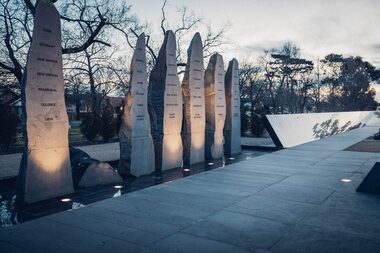 City of Ballarat
Artwork, other - Public Artwork, Ex-Prisoners of War Memorial by Peter Blizzard, 2004
This memorial designed by Peter Blizzard is dedicated to more than 36,000 Australian men and women were held captive as prisoners by the enemy during the Boer War, World War 1, World War 2 and the Korean War. This memorial honours and names them, the names are etched into the black granite wall adjacent to the pathway. Water springs from beneath the 'Lest We Forget' stone then flows down the wall into the narrow watercourse in front of the first group of names and into the reflective pool, then continues past the second group of names. Finally it disappears under the pathway, returning to its source under the 'Lest We Forget' stone to start the journey again. Water symbolizes the essential nature of man, sacrifice, suffering, spirituality, healing, cleansing, birth and re-birth. The memorial is created from natural materials and is designed to be in harmony with the Ballarat Botanical Gardens, and to create a sense of timeless, dignity and respect. The long pathway of the monument is designed to create a visual perspective of the large distances that Australians travelled to the various conflicts. The paving is shaped like railway sleepers in recognition of the role that railways and railway journeys were relevant to many prisoners of war. The Memorial was declared the first military memorial of national significance located outside Canberra in 2008. Dedication services are held at the memorial on the Sunday closest to 6th of February, ANZAC day and on Remembrance Day. The memorial is of historical and aesthetic importance to the people of BallaratMonument made from carved bluestone, water feature and flagsInscribed with the names of 36,000 Australian men and women were held captive as prisoners by the enemy during the Boer War, World War 1, World War 2 and the Korean War. The listing is by surname and initials and shown by war.prisoners of war, boer war, world war 1, world war 2, korean war, lest we forget, peter blizzard -
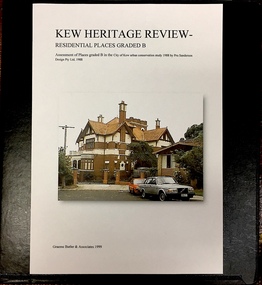 Kew Historical Society Inc
Archive (Sub-series) - Subject File, Kew Heritage Review, Residential Places Graded B, Volume 2, 1999, 1999
Graeme Butler & AssociatesProject FilesProvenance OrderBlack 4-Ring binder that includes research about, and an assessment of buildings previously graded B in the City of Kew Urban Conservation Study 1988 by Pru Sanderson Design Pty Ltd. The files were created by the heritage architect Graeme Butler and the paper files include maps, correspondence, title searches, readings, reviews of prior classifications, newspaper and journal articles, directories etc for each property assessed. graeme butler, heritage reviews - kew, 25 mary street, 4 merrion grove, 24 milfay avenue, 24 miller grove, 26 miller grove, 28 miller grove, 82 molesworth street, 27 princess street, 16 queen street, 20 yarra street, 84 walpole street, 118 walpole street, 11 wellington street, 83 walpole street, 25 wellington street, 8 yarra street, 33 wills street, 63 walpole street, 14 vista avenue, 89 studley park road, 12 tara avenue, 75 studley park road, 21 redmond street, 52 walpole street, 51 walpole street, 71 stevenson street, 34 rowland street, 21 stoke avenue, 34 stevenson street, 44 studley park road, 25 studley park road, 13 studley avenue, 2 second avenue, 11 second avenue, 3 second avenue, 36 stawell street, 12 stevenson streetgraeme butler, heritage reviews - kew, 25 mary street, 4 merrion grove, 24 milfay avenue, 24 miller grove, 26 miller grove, 28 miller grove, 82 molesworth street, 27 princess street, 16 queen street, 20 yarra street, 84 walpole street, 118 walpole street, 11 wellington street, 83 walpole street, 25 wellington street, 8 yarra street, 33 wills street, 63 walpole street, 14 vista avenue, 89 studley park road, 12 tara avenue, 75 studley park road, 21 redmond street, 52 walpole street, 51 walpole street, 71 stevenson street, 34 rowland street, 21 stoke avenue, 34 stevenson street, 44 studley park road, 25 studley park road, 13 studley avenue, 2 second avenue, 11 second avenue, 3 second avenue, 36 stawell street, 12 stevenson street -
 Kew Historical Society Inc
Archive (Sub-series) - Subject File, Kew Heritage Review, Residential Places Graded B, Volume 3, 1999, 1999
Graeme Butler & AssociatesProject FilesProvenance OrderBlack 4-Ring binder that includes research about, and an assessment of buildings previously graded B in the City of Kew Urban Conservation Study 1988 by Pru Sanderson Design Pty Ltd. The files were created by the heritage architect Graeme Butler and the paper files include maps, correspondence, title searches, readings, reviews of prior classifications, newspaper and journal articles, directories etc for each property assessed.graeme butler, heritage reviews - kew, 4 cameron court, 2 hodgson street, 20 fellows street, 26 fellows street, 23 highbury grove, kew lunatic asylum, kew mental hospital, willsmere, 36 stawell street, 13 studley avenue, 16 studley avenue, 20 studley avenue, raheen, studley park road, beament house, 33 uvadale road, 20 yarra streetgraeme butler, heritage reviews - kew, 4 cameron court, 2 hodgson street, 20 fellows street, 26 fellows street, 23 highbury grove, kew lunatic asylum, kew mental hospital, willsmere, 36 stawell street, 13 studley avenue, 16 studley avenue, 20 studley avenue, raheen, studley park road, beament house, 33 uvadale road, 20 yarra street -
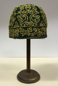 Kew Historical Society Inc
Headwear - Green Cotton & Yellow Silk Ribbon Smoker's or Lounge Cap, 1860s
The context in which the hat was made and worn assists in establishing its potential historic significance. 'Bailliere's Victorian Gazetteer and Road Guide containing the most recent and accurate information as to every place in the Colony' (1870), describes the village of Vaughan as being located on the road from Daylesford to Castlemaine. In 1870 the Vaughan was deemed to be entirely a gold mining area, gold having been discovered in the district in 1853. Intriguingly the entry in the Gazetteer claims that the electoral division of Vaughan began at the junction of the Middleton Creek and the Loddon River, so perhaps the cap might have belonged to a member of a significant local family. In 1870, Vaughan had a population of about 1000 persons and included almost 300 dwellings. Articles from newspapers, published on Trove refer frequently to a Mr Middleton as a litigant in court cases before the Vaughan Court in the 1860s. By the 1870s, the Mt Alexander Mail, in an article on ‘Mining: The Pioneer Wheel’ describes the success of Mr Middleton and his Middleton’s Reef Gold Quartz Mining Company, which had built the largest water wheel in the Colony. The wheel was 20’ in diameter and 2’ wide. Quartz mining as practiced by companies such as Middleton’s had become necessary after the exhaustion of alluvial quartz mining deposits in the 1860s. So we can probably establish a link between the cap and a significant mining identity in the period in which the article was made. The historical significance of the cap is only one part of the story. Caps such as the Middleton example can also be items of aesthetic significance as they were typically, examples of women’s work, using published patterns in magazines such as the Ladies Home Magazine. While women might follow or adapt a published pattern, their choice of materials reflected what was available locally. The fine hand stitching on this example is evidence of high quality domestic needlework. The maker crafted the cap from five triangular pieces of cotton cloth, each piece lined with a faded yellow net. The net provides some stiffening for the cap and has a functional purpose in that it anchors the hand-stitched, looped design of yellow silk ribbon that decorates the surface of the cap. Gentleman’s smoking (lounging) cap believed to have been made in c.1860-69. The conical hat is made of a dark green cotton fabric embroidered with narrow ribbon of a paler green silk. The unlined rimless hat is made of four pieces of fabric. There is no evidence of the hat at one stage featuring a tassle. The original donation record noted that the cap had been made for, and was worn by, a Mr Middleton, of Vaughan in Central Victoria. Nilhats, smokers hats, men's clothing -
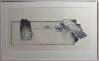 Federation University Art Collection
Work on paper - Printmaking - Coloured etching, Clutterbuck, Jock, 'Mohammed and the Origami Lightning No 1' by Jock Clutterbuck, 1980
Mohammed and the Origami Lightning" was a print I made in 1980, soon after my return from Mossman, north Queensland and a six month stint of studying the metaphysics of Shaik Ibn Arabi with Diane Cilento. The unspeakable omniscience of the prophet is conjured up in the left hand part of the image, and the playfull fantasy of a make believe world in the right hand part. These two realities spliced into the one printed image was what I found very attractive at the time. (March 2021)Jock CLUTTERBUCK (1945- ) Born Edenhope, Victoria Jock Clutterbuck is a sculptor and printmaker of national significance, his prints in colour etchings and aquatints are often from shaped plates and reflect themes found in his sculpture. Known for sophisticated and detailed abstract form, Clutterbuck studied sculpture and drawing at the Royal Melbourne Institute of Technology from 1965 – 1966, where he subsequently taught from 1969 – 1973 before taking up a role as the lecturer in Sculpture at the Victorian College of the Arts from 1974 – 2000. This work is an etching with aquatint and colour stencil on Torinoko An early supporter was Tate Adams, who established the Crossley Gallery to exhibit prints. He urged Jock Clutterbuck to create a series of etchings for Crossley Gallery, a gallery estabished by Tate to exhibit prints. Clutterbuck was awarded the National Gallery of Victoria Society Drawing Prize in 1966, the Australian Print Council Prize in 1969 and 1973, the Geelong Print Prize in 1972, the State Government Bicentenary award for sculpture in 1970, the PCA print prize in 1973, the Fremantle Arts Centre Print Prize in 1976 and the Caulfield Arts Centre Sculpture Award in 1979. This item is part of the Federation University Art Collection. The Art Collection features over 2000 works and was listed as a 'Ballarat Treasure' in 2007. This item is part of the Federation University Art Collection. The Art Collection features over 2000 works and was listed as a 'Ballarat Treasure' in 2007.art, artwork, jock clutterbuck, printmaking, etching, printmaking etching, available -
 Vision Australia
Administrative record - Text, The Association for the Blind, Blind Members' Council meeting minutes 20/6/1975 to 17/7/1981, 1975-1981
These meetings were held at the Kooyong office and the minutes include Present, Chair, Apologies, Minutes, Matter arising from minutes, Correspondence, Life governors, Election of nominees, Nominations, Reports from Finance, Welfare, Brighton, Ballarat, Kooyong, Regional Centres, Nursing homes, Blind Members' auxiliary, Social activities, General business, Guest speakers. The AFB Blind Members' Council Annual Reports are also included beginning with June 30th 1977. Some highlights include: 25/5/1976 it was reported that the newly formed Tandem Bicycle Club would be holding their meetings at Kooyong the first Sunday of each month. 30/6/1978 it was reported that in April the Kooyong complex of buildings was named H.M. Lightfoot Centre after the immediate past President of AFB. The Council has been successful in having included in the learner driver book of road rules a question on the significance of the white cane. 30/7/1979 The Chairman, Mr Sitlington, represented Blind Members at the opening of the Ballarat Day Centre, Kelaston, in April. 30/6/1980 it was reported that the BMC welcomed 119 new members during the past twelve months. The Chairman, Mr Sitlington, represented Blind Members at the opening of the new George Vowell Nursing Home and Day Centre. 20/2/1981 a letter from the Chairman of VicRail, Mr Reiher, giving assurance that audio announcements will still be made in conjunction with the computer board. Minute book for Blind Members Councilassociation for the blind, blind members council -
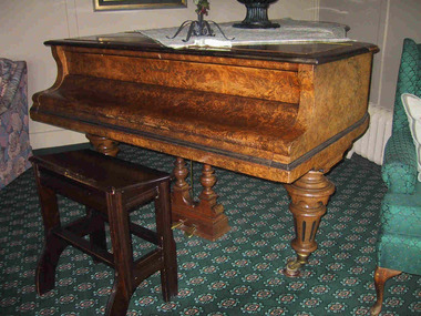 Parks Victoria - Mount Buffalo Chalet
Piano and stool
Bluthner piano dated 1889 (patent no. 32310). PWD engraved imprint to wood. "The Bluthner grand piano came second-hand to the Chalet in 1920 when it was obtained by lessee, Hilda Samsing. This high quality German piano, which stands out as an item of individual significance, is now one of the oldest furnishings in the Chalet. When it was acquired in 1920, the Chalet already had a Beale brand upright piano which had been at the Chalet from the earliest days." (Pg. 77 Historica. 2011) 'A photograph taken of the Music Room (also known as the Drawing Room) between 1920 and 1924, when Hilda Samsing was lessee is one of the earliest known photographs of the Chalet's lounge areas. Published in the undated promotional booklet, Victoria's Wonderland Mount Buffalo, it shows 'A corner of the music room'... On the right, is the Chalet's second piano, which was purchased second-hand in 1920 from Gardner & Lang in Swanston Street, Melbourne. This impressive grand piano of walnut wood still stands in the Chalets Music Room. It was made in the world-famous factory of Julius Bluthner, in Leipzig, Germany, which has made Bluthner pianos since 1853 for numerous royals, composers, conductors, artists, authors and performers including Brahms, Mahler, Bartok, Debussy, Wagner, Strauss, Tchaikovsky and Rachmaninoff. The present stool is not part of the ensemble." ( Pg. 42. Historica )Listed in Draft Inventory of Significant Collection Items. Appendix A.1. Furnishings, Lounges and Hallways (Pg 163. Historica"Bluthner" grand piano made from walnut wood with accomanying wooden stool.(not matching). Piano features three large turned and carved legs on brass castors. Pedals on piano are solid brass, surrounded by carved and turned wooden pedal stand. Stool seat slants towards piano and two plain stretchers support four curved legs. Has 'PWD' stamped on it. PWD engraved imprint to wood. -
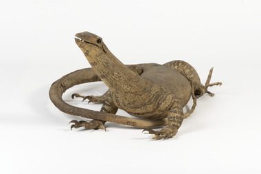 The Beechworth Burke Museum
Animal specimen - Sand Goanna, Trustees of the Australian Museum, 1860-1880
Sand goannas are the second largest species of carnivorous lizards found across mainland Australia. They can grow up to 160cm in length and can weigh as much as 6kg. Their common name is derived from "iguana", since early European bush settlers in Australia likened goannas to the South American lizards. Goannas retain special cultural and historic significance within Australian folklore and Indigenous culture. They were an important traditional native food source and are commonly represented in Aboriginal Dreamtime stories. In some Aboriginal languages, the sand goanna is called "bungarra"; a term also commonly used by non-Aboriginal people in Western Australia. In Pitjantjatjara and other central Australian languages, goannas are called "tingka". This specimen is part of a collection of almost 200 animal specimens that were originally acquired as skins from various institutions across Australia, including the Australian Museum and the National Museum of Victoria, as well as individuals such amateur anthropologist Reynell Eveleigh Johns between 1860-1880. These skins were then mounted by members of the Burke Museum Committee and put-on display in the formal space of the Museum’s original exhibition hall where they continue to be on display. This display of taxidermy mounts initially served to instruct visitors to the Burke Museum of the natural world around them, today it serves as an insight into the collecting habits of the 19th century. This specimen is part of a significant and rare taxidermy mount collection in the Burke Museum. This collection is scientifically and culturally important for reminding us of how science continues to shape our understanding of the modern world. They demonstrate a capacity to hold evidence of how Australia’s fauna history existed in the past and are potentially important for future environmental research. This collection continues to be on display in the Museum and has become a key part to interpreting the collecting habits of the 19th century.Small goanna with a streamlined body and textured scaly skin in different shades of olive and brown. It has a long neck and a long tail which narrows towards the tip. The goanna has four short, stocky legs which meet with large, curled claws. Its mouth is slightly slightly open, and it has two black glass eyes.On tag: BMM / 5892 /taxidermy mount, taxidermy, animalia, burke museum, beechworth, australian museum, skin, reynell eveleigh johns, lizard, goanna, sand goanna, monitor lizard, various gouldii -
 Victorian Aboriginal Corporation for Languages
Book, Sarah Pritchard, Indigenous Peoples, the United Nations and human rights, 1998
Introduction: The significance of international law /? Sarah Pritchard.-- Linking international standards with contemporary concerns of Aboriginal and Torres Strait Islander peoples /? Mick Dodson.-- The UN Charter-based human rights system: The UN Charter-based human rights system: an overview /? Garth Nettheim.-- Working Group on Indigenous Populations: mandate, standard-setting activities and future perspectives /? Sarah Pritchard.-- The UN treaty-based human rights system and individual complaints: The UN treaty-based human rights system: an overview /? Hilary Charlesworth.-- Individual complaints: an overview and admissibility requirements /? Hilary Charlesworth.-- Individual complaints: historical perspectives and the International Covenant on Economic, Social and Cultural Rights /? Philip Alston.-- Individual communications under the Optional Protocol to the International Covenant on Civil and Political Rights Elizabeth Evatt.-- Individual communications: the Convention against Torture and the Convention on the Elimination of All Forms of Racial Discrimination /? Michael O'Flaherty.-- The UN treaty-based human rights system and periodic reporting: Periodic reporting: the International Covenant on Economic, Social and Cultural Rights and the Convention on the Rights of the Child /? Philip Alston.-- Periodic reporting: the International Covenant on Civil and Political Rights and the Convention on the Elimination of All Forms of Discrimination against Women /? Elizabeth Evatt .-- The Committee on the Elimination of Racial Discrimination: non-governmental input and the early warning and urgent procedure /? Michael O'Flaherty.-- Indigenous peoples and some relevant human rights standards: Substantive provisions of the International Convention on the Elimination of All Forms of Racial Discrimination /? Michael O'Flaherty.-- The International Covenant on Civil and Political Rights and Indigenous peoples /? Sarah Pritchard.united nations -- history. indigenous peoples -- legal status, laws, etc. aboriginal australians -- civil rights. aboriginal australians -- legal status, laws, etc. human rights.