Showing 1051 items matching " tents"
-
 Musculoskeletal Health Australia (now held by the Glen Eira Historical Society)
Photograph - Solo photo
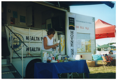
... In the background, some market stall tents and marquees are evident, with tables and deck chairs underneath them....In the background, some market stall tents and marquees are evident, with tables and deck chairs underneath them. ...ACME Field Days are an expo event where exhibitors, particularly from the agricultural sector, can display and promote their products. In the early 2000s, Arthritis Victoria (AV) brought its Healthy Bones Bus to south west Victoria to spread the 'strong bones, healthy joints' message to regional areas. This initiative was made possible through a partnership with the Moyne Shire Council and Moyne Health Services. This photo depicts an unidentified woman staffing AV's Healthy Bones Bus information stall at an ACME Field Day.COL photo of a woman standing behind a rectangular table in front of a large van. On it, there is a range of healthy food items such as cereals, various types of milk, cheeses, yoghurt, a plastic ice cream container, some canned food, and some fresh fruit. The woman is affixing a display label to the top of a milk carton. The van has a large door open on the side, displaying the text, "Osteoporosis Victoria 1800 011 041" (partially obscured). Below the text, there is a display board with some posters on it. Hanging from the inside edge of the van door is a long vertical banner with the text and logo for the Moyne Shire. Behind the woman, there is a large "Moyne Health Services" banner attached to the ballustrade on the side of the van. In the foreground, to the left of the frame, there are some metal steps with a ballustrade. In the background, some market stall tents and marquees are evident, with tables and deck chairs underneath them.arthritis foundation of victoria, afv, osteoporosis victoria, ov, arthritis victoria, av, acme field day, healthy bones bus, outreach, education, information stall, healthy food, heathy diet, calcium, bone health, strong bones, south west victoria, moyne shire, moyne health services, sponsorship, partnership, c2000s -
 Bendigo Historical Society Inc.
Document - BARBARA MAMOUNEY COLLECTION: COPY OF PRINTED PAGE
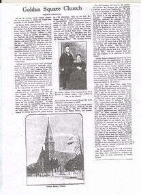
... Jeffrey continued with similar activities with increasing interest and attendances. Beginning with a tent surrounded by a fence a disused shed was bought and relocated to the site and was the finest building in the district. ...Jeffrey continued with similar activities with increasing interest and attendances. Beginning with a tent surrounded by a fence a disused shed was bought and relocated to the site and was the finest building in the district. ...Photocopy of a published page, marked as Eightieth Anniversary, relating to records as showing Golden Square as the first place in the Bendigo area at which the gospel was preached. On arriving from South Australia in 1852, attracted by the news of gold in the area James Jeffrey widely known later as Jimmy Jeffrey, a preacher who noticed that the sanctity of the Sabbath was being ignored, with normal chores and entertainment being the order of everyday. In short, little regard was shown for religion and there were no ministers. With a tree stump as his pulpit Jimmy began service by singing a Methodist hymn heartily, attracting a band of diggers to listen, with continuous services in Golden Square taking place ever since. Jeffrey continued with similar activities with increasing interest and attendances. Beginning with a tent surrounded by a fence a disused shed was bought and relocated to the site and was the finest building in the district. Late in 1852 the first real Church was erected in place of the shed and the tent. Enthusiasm and numbers of attendees swelled and in 1859 Reverend Joseph Dare and Robert Lisle and other church leaders purchased land (for 30 pounds) and had the foundation stone for a new Church building was laid by Reverend Daniel J.Draper on19th of April 1859 with Divine Service and Public Worship conducted from 11th December that year by Reverend Mr Draper. A collection on the day raised 262 pounds. The foundation stone for the present Church was financed by Richard Allingham laid on 5th January 1870. The first minister who went to the district was Reverend Mr Symonds who was stationed at Forest Creek near Castlemaine. Reverend Richard Hart was the first minister stationed at Golden Square. Embedded in the article is an image of Jimmy and Mrs Jeffrey. On the reverse of the article is a copy of a drawing by Reverend Aswel Aptel circa 1853.fra margolden square methodist church, wesleyan church, mamouney, church, richard allingham reverends jimmy jeffrey, william robert lisle robert draper, william taylor, symonds, j dare, chapman, hilson t raston, richard hart, wm shaw. g a pethard, robert saunders. reverse side a sketch of the church circa 1853 by aswel aptel. james cox (sec) mrs foot (teacher). -
 Conservation Volunteers
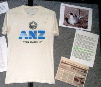
Tern Watch ANZ Bank promotional T shirt 1988 For five summers from 1987 to 1992 ATCV volunteers were landed on Rigby Island in Victoria’s Gippsland Lakes to “baby-sit” Little Terns, 1988
... Terry Peacock’s logistics were heroic In support of the volunteers’ vigil: a boat, bunks, tents, tools, and a kitchen were bussed from Bendigo to Lakes Entrance. ...Terry Peacock’s logistics were heroic In support of the volunteers’ vigil: a boat, bunks, tents, tools, and a kitchen were bussed from Bendigo to Lakes Entrance. ...For five summers from 1987 to 1992 ATCV volunteers were landed on Rigby Island in Victoria’s Gippsland Lakes to “baby-sit” Little Terns (Sterna Albifrons) which breed in Asia and visit Australia in the Northern winter. By the mid 1980s the visiting population had dwindled dangerously due to predation and its very slow rate of reproduction. Conservation volunteers patrolled from dawn to dusk on a rotating 4 hour shift, educating visitors why they should stay away from the birds, and kept watch for pests. Terry Peacock’s logistics were heroic In support of the volunteers’ vigil: a boat, bunks, tents, tools, and a kitchen were bussed from Bendigo to Lakes Entrance. There were no outside funds at first, and only sale of promotional T-shirts together with small grants from the ANZ Bank and from Yellow Pages kept things going. Volunteers paid their own way to and from Bairnsdale railway station. Park Ranger and former ATCV employee Robert Brouwers with Helen Schneider (UK naturalist) and Tim Cox ‘maroon’ Tern Watch volunteers at Rigby Island in the Gippsland Lakes Vic > In 2010 the status of the Little Tern populations in Australia was assessed under the ECBP Act and the determination was that, while the Gippsland Lakes population will continue to benefit from conservation action, they are no longer a threatened species. White T shirt with ANZ in large blue letters with Tern Watch 1988 belowtern watch, atcv -
 Falls Creek Historical Society
Photograph - Bogong Alpine Village 1941
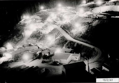
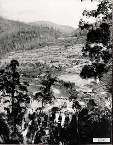
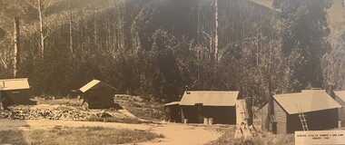
... The workmen's camp was originally started with tents and was called Junction Camp. By 1947, the village supported 300 workers and their families. ...The workmen's camp was originally started with tents and was called Junction Camp. By 1947, the village supported 300 workers and their families. ...The images in the Bogong Village Collection were displayed in Bogong Jack’s Tavern for over 20 years and were donated to the Falls Creek Museum when the Tavern closed in 2021. In 1939, the State Electricity Commission of Victoria established a field headquarters at Bogong to house workers and their families for the Kiewa Hydroelectric Scheme which ran from the 1930s to the 1960s. The workmen's camp was originally started with tents and was called Junction Camp. By 1947, the village supported 300 workers and their families. It included 40 houses, a hostel for single staff, a post office, a police station, a medical centre, and a primary school. The staff hostel was known as Kiewa House. At the completion of the Scheme, in the 1960s, the village was opened to public/tourism use. In 1968 the Victorian Education Department acquired the camp buildings and four houses from the State Electricity Commission of Victoria to establish an Outdoor Education Centre which operated for over 50 years. The Kiewa Hydroelectric Scheme was privatized in the 1990s and sold to Southern Hydro, before being acquired by AGL in 2005. In 2023 the Grollo Group signed a 73 year sublease on Bogong Village and has plans for its redevelopment as a workers’ village.These images are significant because they capture the development of Bogong Village as an important element of the Kiewa Hydroelectric Scheme in Victoria.A collection of four black and white images capturing the development of Bogong Alpine Village. They depict development of the new village, the surrounding area and some staff members during 1941.bogong alpine village, bogong high plains, bogong 1941 -
 Falls Creek Historical Society
Photograph - Bogong Alpine Village 1942
... The workmen's camp was originally started with tents and was called Junction Camp. By 1947, the village supported 300 workers and their families. ...The workmen's camp was originally started with tents and was called Junction Camp. By 1947, the village supported 300 workers and their families. ...The images in the Bogong Village Collection were displayed in Bogong Jack’s Tavern for over 20 years and were donated to the Falls Creek Museum when the Tavern closed in 2021. In 1939, the State Electricity Commission of Victoria established a field headquarters at Bogong to house workers and their families for the Kiewa Hydroelectric Scheme which ran from the 1930s to the 1960s. The workmen's camp was originally started with tents and was called Junction Camp. By 1947, the village supported 300 workers and their families. It included 40 houses, a hostel for single staff, a post office, a police station, a medical centre, and a primary school. The staff hostel was known as Kiewa House. At the completion of the Scheme, in the 1960s, the village was opened to public/tourism use. In 1968 the Victorian Education Department acquired the camp buildings and four houses from the State Electricity Commission of Victoria to establish an Outdoor Education Centre which operated for over 50 years. The Kiewa Hydroelectric Scheme was privatized in the 1990s and sold to Southern Hydro, before being acquired by AGL in 2005. In 2023 the Grollo Group signed a 73 year sublease on Bogong Village and has plans for its redevelopment as a workers’ village.These images are significant because they capture the development of Bogong Village as an important element of the Kiewa Hydroelectric Scheme in Victoria.A collection of four black and white images capturing the development of Bogong Alpine Village and the Pretty Valley area during 1942.bogong alpine village, bogong high plains, bogong 1942 -
 Falls Creek Historical Society
Photograph - Bogong Alpine Village 1943
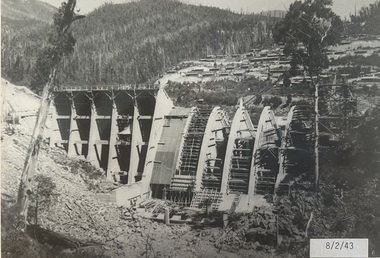
... The workmen's camp was originally started with tents and was called Junction Camp. By 1947, the village supported 300 workers and their families. ...The workmen's camp was originally started with tents and was called Junction Camp. By 1947, the village supported 300 workers and their families. ...The images in the Bogong Village Collection were displayed in Bogong Jack’s Tavern for over 20 years and were donated to the Falls Creek Museum when the Tavern closed in 2021. In 1939, the State Electricity Commission of Victoria established a field headquarters at Bogong to house workers and their families for the Kiewa Hydroelectric Scheme which ran from the 1930s to the 1960s. The workmen's camp was originally started with tents and was called Junction Camp. By 1947, the village supported 300 workers and their families. It included 40 houses, a hostel for single staff, a post office, a police station, a medical centre, and a primary school. The staff hostel was known as Kiewa House. At the completion of the Scheme, in the 1960s, the village was opened to public/tourism use. In 1968 the Victorian Education Department acquired the camp buildings and four houses from the State Electricity Commission of Victoria to establish an Outdoor Education Centre which operated for over 50 years. The Kiewa Hydroelectric Scheme was privatized in the 1990s and sold to Southern Hydro, before being acquired by AGL in 2005. In 2023 the Grollo Group signed a 73 year sublease on Bogong Village and has plans for its redevelopment as a workers’ village.These images are significant because they capture the development of Bogong Village as an important element of the Kiewa Hydroelectric Scheme in Victoria.A collection of seven black and white images capturing the development of Bogong Alpine Village and the Pretty Valley area during 1943.bogong alpine village, bogong high plains, bogong 1943 -
 Falls Creek Historical Society
Photograph - Bogong Alpine Village 1944
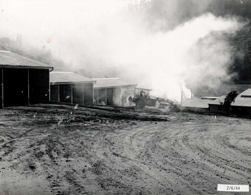
... The workmen's camp was originally started with tents and was called Junction Camp. By 1947, the village supported 300 workers and their families. ...The workmen's camp was originally started with tents and was called Junction Camp. By 1947, the village supported 300 workers and their families. ...The images in the Bogong Village Collection were displayed in Bogong Jack’s Tavern for over 20 years and were donated to the Falls Creek Museum when the Tavern closed in 2021. In 1939, the State Electricity Commission of Victoria established a field headquarters at Bogong to house workers and their families for the Kiewa Hydroelectric Scheme which ran from the 1930s to the 1960s. The workmen's camp was originally started with tents and was called Junction Camp. By 1947, the village supported 300 workers and their families. It included 40 houses, a hostel for single staff, a post office, a police station, a medical centre, and a primary school. The staff hostel was known as Kiewa House. At the completion of the Scheme, in the 1960s, the village was opened to public/tourism use. In 1968 the Victorian Education Department acquired the camp buildings and four houses from the State Electricity Commission of Victoria to establish an Outdoor Education Centre which operated for over 50 years. The Kiewa Hydroelectric Scheme was privatized in the 1990s and sold to Southern Hydro, before being acquired by AGL in 2005. In 2023 the Grollo Group signed a 73 year sublease on Bogong Village and has plans for its redevelopment as a workers’ village.These images are significant because they capture the development of Bogong Village as an important element of the Kiewa Hydroelectric Scheme in Victoria.A collection of four black and white images capturing the weather conditions in the Bogong area in June 1944bogong alpine village, bogong high plains, bogong june 1944 -
 Falls Creek Historical Society
Photograph - Bogong Alpine Village Houses 1946
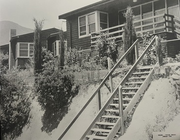
... The workmen's camp was originally started with tents and was called Junction Camp. By 1947, the village supported 300 workers and their families. ...The workmen's camp was originally started with tents and was called Junction Camp. By 1947, the village supported 300 workers and their families. ...The images in the Bogong Village Collection were displayed in Bogong Jack’s Tavern for over 20 years and were donated to the Falls Creek Museum when the Tavern closed in 2021. In 1939, the State Electricity Commission of Victoria established a field headquarters at Bogong to house workers and their families for the Kiewa Hydroelectric Scheme which ran from the 1930s to the 1960s. The workmen's camp was originally started with tents and was called Junction Camp. By 1947, the village supported 300 workers and their families. It included 40 houses, a hostel for single staff, a post office, a police station, a medical centre, and a primary school. The staff hostel was known as Kiewa House. At the completion of the Scheme, in the 1960s, the village was opened to public/tourism use. In 1968 the Victorian Education Department acquired the camp buildings and four houses from the State Electricity Commission of Victoria to establish an Outdoor Education Centre which operated for over 50 years. The Kiewa Hydroelectric Scheme was privatized in the 1990s and sold to Southern Hydro, before being acquired by AGL in 2005. In 2023 the Grollo Group signed a 73 year sublease on Bogong Village and has plans for its redevelopment as a workers’ village.These images are significant because they capture the development of Bogong Village as an important element of the Kiewa Hydroelectric Scheme in Victoria.Two black and white images featuring houses in Bogong Village in January 1946. They are constructed of weatherboard, with brick chimneys and tin roofs. Timber steps lead up to the front door and a garden has been planted in front of the house.bogong alpine village, bogong high plains, bogong houses 1946 -
 Falls Creek Historical Society
Photograph - Bogong Alpine Village 1947
... The workmen's camp was originally started with tents and was called Junction Camp. By 1947, the village supported 300 workers and their families. ...The workmen's camp was originally started with tents and was called Junction Camp. By 1947, the village supported 300 workers and their families. ...The images in the Bogong Village Collection were displayed in Bogong Jack’s Tavern for over 20 years and were donated to the Falls Creek Museum when the Tavern closed in 2021. In 1939, the State Electricity Commission of Victoria established a field headquarters at Bogong to house workers and their families for the Kiewa Hydroelectric Scheme which ran from the 1930s to the 1960s. The workmen's camp was originally started with tents and was called Junction Camp. By 1947, the village supported 300 workers and their families. It included 40 houses, a hostel for single staff, a post office, a police station, a medical centre, and a primary school. The staff hostel was known as Kiewa House. At the completion of the Scheme, in the 1960s, the village was opened to public/tourism use. In 1968 the Victorian Education Department acquired the camp buildings and four houses from the State Electricity Commission of Victoria to establish an Outdoor Education Centre which operated for over 50 years. The Kiewa Hydroelectric Scheme was privatized in the 1990s and sold to Southern Hydro, before being acquired by AGL in 2005. In 2023 the Grollo Group signed a 73 year sublease on Bogong Village and has plans for its redevelopment as a workers’ village.These images are significant because they capture the development of Bogong Village as an important element of the Kiewa Hydroelectric Scheme in Victoria.Two black and white images capturing Bogong Village by night and the spillway at Junction Dam.bogong alpine village, bogong high plains, bogong 1947 -
 Falls Creek Historical Society
Photograph - Bogong Alpine Village and Howman's Dam Camp 1948
... The workmen's camp was originally started with tents and was called Junction Camp. By 1947, the village supported 300 workers and their families. ...The workmen's camp was originally started with tents and was called Junction Camp. By 1947, the village supported 300 workers and their families. ...The images in the Bogong Village Collection were displayed in Bogong Jack’s Tavern for over 20 years and were donated to the Falls Creek Museum when the Tavern closed in 2021. In 1939, the State Electricity Commission of Victoria established a field headquarters at Bogong to house workers and their families for the Kiewa Hydroelectric Scheme which ran from the 1930s to the 1960s. The workmen's camp was originally started with tents and was called Junction Camp. By 1947, the village supported 300 workers and their families. It included 40 houses, a hostel for single staff, a post office, a police station, a medical centre, and a primary school. The staff hostel was known as Kiewa House. At the completion of the Scheme, in the 1960s, the village was opened to public/tourism use. In 1968 the Victorian Education Department acquired the camp buildings and four houses from the State Electricity Commission of Victoria to establish an Outdoor Education Centre which operated for over 50 years. The Kiewa Hydroelectric Scheme was privatized in the 1990s and sold to Southern Hydro, before being acquired by AGL in 2005. In 2023 the Grollo Group signed a 73 year sublease on Bogong Village and has plans for its redevelopment as a workers’ village.These images are significant because they capture the development of Bogong Village as an important element of the Kiewa Hydroelectric Scheme in Victoria.Two images capturing the depiction Bogong Village and the Howman's Dam Camp 1948bogong alpine village, bogong high plains, bogong 1947 -
 Falls Creek Historical Society
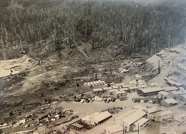
Photograph - Aerial View of Bogong Alpine Village
... The workmen's camp was originally started with tents and was called Junction Camp. By 1947, the village supported 300 workers and their families. ...The workmen's camp was originally started with tents and was called Junction Camp. By 1947, the village supported 300 workers and their families. ...The images in the Bogong Village Collection were displayed in Bogong Jack’s Tavern for over 20 years and were donated to the Falls Creek Museum when the Tavern closed in 2021. In 1939, the State Electricity Commission of Victoria established a field headquarters at Bogong to house workers and their families for the Kiewa Hydroelectric Scheme which ran from the 1930s to the 1960s. The workmen's camp was originally started with tents and was called Junction Camp. By 1947, the village supported 300 workers and their families. It included 40 houses, a hostel for single staff, a post office, a police station, a medical centre, and a primary school. The staff hostel was known as Kiewa House. At the completion of the Scheme, in the 1960s, the village was opened to public/tourism use. In 1968 the Victorian Education Department acquired the camp buildings and four houses from the State Electricity Commission of Victoria to establish an Outdoor Education Centre which operated for over 50 years. The Kiewa Hydroelectric Scheme was privatized in the 1990s and sold to Southern Hydro, before being acquired by AGL in 2005. In 2023 the Grollo Group signed a 73 year sublease on Bogong Village and has plans for its redevelopment as a workers’ village.These images are significant because they capture the development of Bogong Village as an important element of the Kiewa Hydroelectric Scheme in Victoria.An aerial view of Bogong Village and surrounds, date unknown.bogong alpine village, bogong high plains, aerial photos bogong village -
 Parks Victoria - Cape Nelson Lightstation
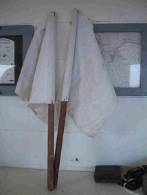
Functional object - Flags, semaphore
... Evan Evans (d.1927) started a tent‐making business in 1877 and by 1920 Evan Evans P/L maker of canvas goods, was located at 680 Elizabeth Street, Melbourne. ...Evan Evans (d.1927) started a tent‐making business in 1877 and by 1920 Evan Evans P/L maker of canvas goods, was located at 680 Elizabeth Street, Melbourne. ...The two semaphore flags were used as a pair for visual signaling by hand. The semaphore system is an alphabet signaling system based on the waving of a pair of handheld flags in a particular pattern to compose words to be communicated to passing ships. The system was introduced by the Royal Navy in 1880 and was later adopted in Australia, with the first School of Signaling opening in Williamstown in 1890. The system was superseded in the 1970s by more sophisticated methods of communication. Information on the Cape Nelson flags indicates that they were made by Evan Evans P/L, Flag makers, 690 Elizabeth Street, Melbourne. Evan Evans (d.1927) started a tent‐making business in 1877 and by 1920 Evan Evans P/L maker of canvas goods, was located at 680 Elizabeth Street, Melbourne. In 1924 it acquired land at 632 Bourke Street and built a new factory. His son Ivor continued the business after 1927 and in 1938 opened a bulk store in Carlton.271 In 2016 the firm was located at 673 Spencer Street, Melbourne. Another pair of white semaphore flags made by Evan & Evans is held at Gabo Island, and Wilsons Promontory also has a pair. Cape Nelson’s white semaphore flags have second level contributory significance. They have historical importance as flags formerly used at the lightstation for visual signaling, a system that is now rarely used in navigation, and contribute to the importance of the lightstation’s large collection of flags.A pair of white flags made of white canvas/heavy cotton, the square flags are attached to dowel poles with staples. -
 Eltham District Historical Society Inc
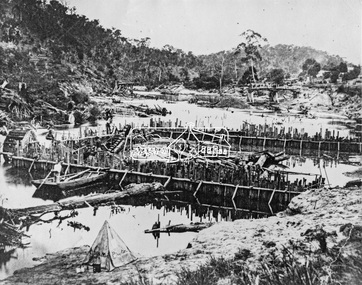
Negative - Photograph, Carl Walter 1831-1907, Coffer dam in the Yarra River at Anderson's Creek, 1864
... Photo: Carl Walter 1831-1907 – inscribed on tent “C. Walter Photo” The State Library of Victoria holds over 150 photos by Carl Walter, most of which are portraits of Aboriginal natives including William Barak....Photo: Carl Walter 1831-1907 – inscribed on tent “C. Walter Photo” The State Library of Victoria holds over 150 photos by Carl Walter, most of which are portraits of Aboriginal natives including William Barak. ...1864 photograph of the Coffer Dam in the River Yarra situated (approximately) opposite Whipstick Gully. Remains of bridge built in 1860(?) wrecked by 1863 flood in background. Reproduced page 29 of ‘Pioneers & Painters’ Gold was first discovered in this area at Andersons Creek (Warrandyte) in June 1851 by Louis Michel. Discoveries north of the Yarra did not occur until about 1854. Although it took some months for a true rush to develop it was not long before alluvial workings were being carried on in most of the Shire of Eltham. The last area in which gold was discovered was Kinglake. As the gold became harder to find, deep mining took over from alluvial diggings in the gullies. Perhaps the most extensive of the deep workings was the Diamond Creek Mine just outside the boundary of the Shire. This form of mining was continued into the 1930s. There are believed to be some mines in the area still capable of producing gold but present prices make working these uneconomical. Some gold is still found by weekend prospectors. Photo: Carl Walter 1831-1907 – inscribed on tent “C. Walter Photo” The State Library of Victoria holds over 150 photos by Carl Walter, most of which are portraits of Aboriginal natives including William Barak.This photo forms part of a collection of photographs gathered by the Shire of Eltham for their centenary project book,"Pioneers and Painters: 100 years of the Shire of Eltham" by Alan Marshall (1971). The collection of over 500 images is held in partnership between Eltham District Historical Society and Yarra Plenty Regional Library (Eltham Library) and is now formally known as 'The Shire of Eltham Pioneers Photograph Collection.' It is significant in being the first community sourced collection representing the places and people of the Shire's first one hundred years.Digital image 4 x 5 inch B&W Neg (2) Print 20 x 25 cmshire of eltham pioneers photograph collection, anderson's creek, coffer dam, floods, gold mining, other areas, pioneers and painters, warrandyte, warrandyte bridge, yarra river -
 National Wool Museum
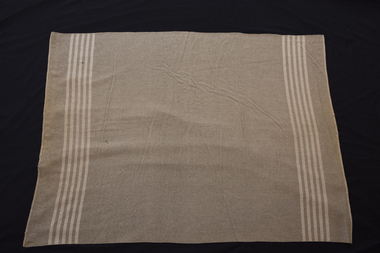
Blanket, Standard issue army blanket
... Issued with two blankets, it was all a soldier had as a bed to keep warm or without a tent, all they had to provide shelter from the sun, rain or wind. ...Issued with two blankets, it was all a soldier had as a bed to keep warm or without a tent, all they had to provide shelter from the sun, rain or wind. ...Maker unknown. This blanket was part of the standard army issue kit and belonged to Lois Denshams father, who served at Gallipoli during the first world war. Before donating the blanket to the Running stitch collection, it was kept by Lois' Aunty Nita. Lois remembers that it was kept in her fathers original kit bag and kept at her aunts place because of sad memories about the war which her mother found difficult. The humble army blanket had many uses during war times. Issued with two blankets, it was all a soldier had as a bed to keep warm or without a tent, all they had to provide shelter from the sun, rain or wind. (They were supplemented with a woollen army 'great coat', but soldiers still had to huddle together as keeping warm and dry was a desperate game.) The Lighthorsemen used them under their standard leather saddles for extra padding and in the hospitals they were sometimes the only bedding for the wounded. This blanket belonged to Lois Denshams' father who served in the Australian Army in the First World War, landing at Gallipoli. Since the war, army blankets have come to be regarded as the basic type of blanket -no frills. This blanket was used in the Densham family since that time for camping trips.Grey woollen army blanket with stripes near either ends.world war i, running stitch group, running stitch collection -
 Falls Creek Historical Society
Photograph - Bogong Alpine Village 1940
... The workmen's camp was originally started with tents and was called Junction Camp. By 1947, the village supported 300 workers and their families. ...The workmen's camp was originally started with tents and was called Junction Camp. By 1947, the village supported 300 workers and their families. ...The images in the Bogong Village Collection were displayed in Bogong Jack’s Tavern for over 20 years and were donated to the Falls Creek Museum by the Liz Krien & the Bogong Village Trust Board when the Tavern closed in 2021. In 1939, the State Electricity Commission of Victoria established a field headquarters at Bogong to house workers and their families for the Kiewa Hydroelectric Scheme which ran from the 1930s to the 1960s. The workmen's camp was originally started with tents and was called Junction Camp. By 1947, the village supported 300 workers and their families. It included 40 houses, a hostel for single staff, a post office, a police station, a medical centre, and a primary school. The staff hostel was known as Kiewa House. At the completion of the Scheme, in the 1960s, the village was opened to public/tourism use. In 1968 the Victorian Education Department acquired the camp buildings and four houses from the State Electricity Commission of Victoria to establish an Outdoor Education Centre which operated for over 50 years. The Kiewa Hydroelectric Scheme was privatized in the 1990s and sold to Southern Hydro, before being acquired by AGL in 2005. In 2023 the Grollo Group signed a 73 year sublease on Bogong Village and has plans for its redevelopment as a workers’ village.These images are significant because they capture the development of Bogong Village as an important element of the Kiewa Hydroelectric Scheme in Victoria.A collection of 10 black and white images capturing the development of Bogong Alpine Village. They depict development of the new village, the surrounding area and some staff members during 1940.bogong alpine village, bogong 1940, bogong high plains -
 Bendigo Military Museum
Photograph - PHOTOGRAPHS WW1, 2) 29/08/1916
... A small dog in the front row. .2) Postcard photo of soldier in pith helmet beside palm tress, B&W. .3) Postcard photo of soldier standing with crop, B&W. .4) Postcard photo of soldier standing with officers cane, B&W. .5) Postcard photo of soldier standing with riding crop, B&W. .6) Postcard photo of 11 soldiers outside a hut, B&W. .7) Photo postcard of soldier with "Red Cross" on arm, B&W. .8) Photo postcard of soldier, portrait, B&W. .9) Photo, postcard of group of soldiers (10) outside tents, B&W. .10) Photo, postcard of soldier standing outside building holding a crop, B&W. ...A small dog in the front row. .2) Postcard photo of soldier in pith helmet beside palm tress, B&W. .3) Postcard photo of soldier standing with crop, B&W. .4) Postcard photo of soldier standing with officers cane, B&W. .5) Postcard photo of soldier standing with riding crop, B&W. .6) Postcard photo of 11 soldiers outside a hut, B&W. .7) Photo postcard of soldier with "Red Cross" on arm, B&W. .8) Photo postcard of soldier, portrait, B&W. .9) Photo, postcard of group of soldiers (10) outside tents, B&W. .10) Photo, postcard of soldier standing outside building holding a crop, B&W. ....1) Is re Evan. EVANS No. 3114 in 6th Batt. 10th Reinforcements then transferred to 1st Pioneers. .2) "To Joe & Linne from cousin Leslie 3rd/38th Batt." .10) Letter is to Joe & Linne from apparently "Jim" .1) Re Evans. There is an Evan Owens No 3114 enlisted in 10th reinforcements 6th Batt AIF on 10.7.1915 age 21 years. Em bark for Egypt 29.9.1915, transfer to 1st Pioneer Batt 12.3.1916, embark for France 2.3.1916, WIA 22/27 .7.1916 GSW head, rejoin unit 16.10.1916, discharged from the AIF 3.8.1919. .2) Re Leslie. This possibly Albert Leslie Owens (brother to Evan) No 953, enlisted in the AIF in C Coy 38th Batt on 21.2.1916 age 24 years. Embark for England 20.6.1916, hospital with Measles 18.8.1916, embark for France 22.11.1916, detached to 10th Light Trench Mortar Battery, WIA 6.5.1917 GSW to face and left eye, while recovering he was admitted to hospital 13.8.1917 with Retinitis (eye), returned to Australia and discharged medically unfit 5.2.1918..1) Photo, sepia colour showing large group of soldiers (46) seated on a hill side. A small dog in the front row. .2) Postcard photo of soldier in pith helmet beside palm tress, B&W. .3) Postcard photo of soldier standing with crop, B&W. .4) Postcard photo of soldier standing with officers cane, B&W. .5) Postcard photo of soldier standing with riding crop, B&W. .6) Postcard photo of 11 soldiers outside a hut, B&W. .7) Photo postcard of soldier with "Red Cross" on arm, B&W. .8) Photo postcard of soldier, portrait, B&W. .9) Photo, postcard of group of soldiers (10) outside tents, B&W. .10) Photo, postcard of soldier standing outside building holding a crop, B&W. Letter written on the back in ink, B&W.photography-photographs, military history - army -
 Bendigo Historical Society Inc.
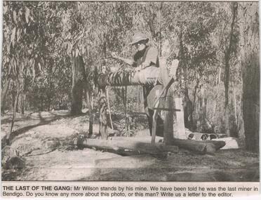
Newspaper - JENNY FOLEY COLLECTION: THE LAST OF THE GANG
... The site consisted of a small clearing, similar to the one depicted, occupied by a small tent, the shaft and windlass. He later sank another shaft adjacent to Retreat Road, towards the Spring Gully hotel. ...The site consisted of a small clearing, similar to the one depicted, occupied by a small tent, the shaft and windlass. He later sank another shaft adjacent to Retreat Road, towards the Spring Gully hotel. ...Bendigo Advertiser ''The way we were'' from 2003. The last of the gang: Mr. Wilson stands by his mine. We have been told he was the last miner in Bendigo. Bendigo Advertiser from 2003. Memories of an old miner: I think your photo depicting what could have been the very last miner in Bendigo may be that of an old timer who sunk a shaft in the Flora hill area (now Hyett Estate?) in about 1950. He was known to us as ''old Tim''. The shaft was close to an existing mine drive which children of the day referred to as ''the Devil's Den''. We regularly assisted him with the windlass winding and panning. The site consisted of a small clearing, similar to the one depicted, occupied by a small tent, the shaft and windlass. He later sank another shaft adjacent to Retreat Road, towards the Spring Gully hotel. Letter written by Ron Nancarrow, Britain street Eaglehawk.newspaper, bendigo advertiser, the way we were -
 Bendigo Historical Society Inc.
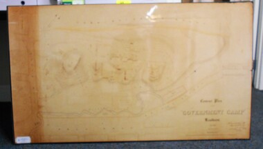
Map - CONTOUR PLAN OF THE GOVERNMENT CAMP SANDHURST 1854, 1994
... Wooden buildings tinted in Indian Ink. Tents and other temporary structures tinted in Burnt Sienna.' ...Wooden buildings tinted in Indian Ink. Tents and other temporary structures tinted in Burnt Sienna.' ...Contour map (copy) of the Government Camp Sandhurst, 1854. Map is mounted on coreflute and laminated. Written in bottom righthand corner 'Contour Plan of the Government Camp, Sandhurst. Dec 1854. Signed by Richard Larritt, Assistant Surveyor, 11th December 1854.' Shown on map: Pall Mall, Bendigo Creek, Commissioner's Gully, View Place (now View Street), Post Office, Bank of Victoria, District Surgeon, Sandhurst Fire Brigade, Police Hospital, Flagstaff, Gold Office, License Shed, Military Barracks, Stables, Commissioner's Buildings, Police Office. Old Cemetery, Garden. Reference on righthand side: 'Stone or brick buildings are tinted in crimson. Wooden buildings tinted in Indian Ink. Tents and other temporary structures tinted in Burnt Sienna.' Scale of Chains, on bottom of map. Sticker on bottom left hand corner and back of map ' Presented by Survey and Mapping, Victoria, 7th Octber, 1994'.map, bendigo, government camp, pall mall, bendigo creek, commissioner's gully, view place (now view street), post office, bank of victoria, district surgeon, sandhurst fire brigade, police hospital, flagstaff, gold office, license shed, military barracks, stables, commissioner's buildings, police office. old cemetery, garden. , survey and mapping victoria. sandhurst, bendigo. -
 Bendigo Historical Society Inc.
Slide - DIGGERS & MINING. GETTING THE GOLD, c1850s
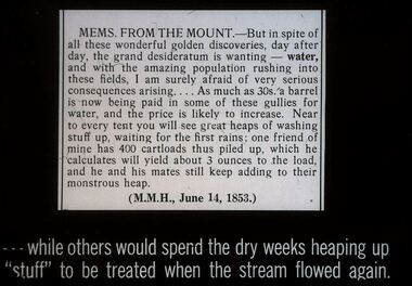
... As much as 30s. a barrel is now being paid I some of these gullies for water, and the price is likely to increase. Near to every tent you will see great heaps of washing stuff up, waiting for the first rains; one friend of mine has 400 cartloads this piled up, which he calculates will yield about 3 ounces to the load, and he and his mates still keep adding to their monstrous heap. ...As much as 30s. a barrel is now being paid I some of these gullies for water, and the price is likely to increase. Near to every tent you will see great heaps of washing stuff up, waiting for the first rains; one friend of mine has 400 cartloads this piled up, which he calculates will yield about 3 ounces to the load, and he and his mates still keep adding to their monstrous heap. ...Diggers & Mining. Getting the Gold. Slide: MEMS FROM THE MOUNT - But in spite of all these wonderful golden discoveries, day after day, the grand desideratum is wanting - water, and with the amazing population rushing into these fields. I am surely afraid of very serious consequences arising . . . . As much as 30s. a barrel is now being paid I some of these gullies for water, and the price is likely to increase. Near to every tent you will see great heaps of washing stuff up, waiting for the first rains; one friend of mine has 400 cartloads this piled up, which he calculates will yield about 3 ounces to the load, and he and his mates still keep adding to their monstrous heap. (M.M.H., June 14, 1853.) . . .while others would spend the dry weeks heaping up ''stuff'' to be treated when the stream flowed again Markings: 68 994.LIF:4. Used as a teaching aid.hanimounteducation, tertiary, goldfields -
 Eltham District Historical Society Inc
Certificate, Rotary Club of Eltham, Certificate, Festival Parade Award, Rotary Club of Eltham, Eighth Eltham Community Festival 1982, 1982
... This has prompted the suggestion for future parades that we have a tent or other suitable venue for members to gather after the event. ...This has prompted the suggestion for future parades that we have a tent or other suitable venue for members to gather after the event. ...Eltham Community Festival awards. Awarded to the Shire of Eltham Historical Society for the most effort by locals. Newsletter No. 27, November 1982 ELTHAM COMMUNITY FESTIVAL Although our parade entry did not win a prize this year, it was considered highly successful from a participation point of view. Despite some uncertainty as to just who was corning, members and friends kept appearing at the assembly area . As in the past years our friends from the Victorian Folk Music·Club brought their instruments along and really added to the occasion. This year we concentrated on a rural theme with a tractor/trailer combination. Thanks to Peter Bassett-Smith for the tractor, Joh Ebeli for the decorations and friendly trailer owner Dennis McKay. Unfortunately the closing stages of the parade were marred by heavy rain. We just finished as the rain started but members scattered very quickly. This has prompted the suggestion for future parades that we have a tent or other suitable venue for members to gather after the event. This is worth following up. The cold driving rain provided a special problem for Peter in driving his tractor home to Kangaroo Ground. Have you ever had to choose between standing up to warm your hands on the exhaust and having your tractor seat flooded? Paper certificate printed with handwritten award nomination and categoryawards, eltham festival, rotary club of eltham, shire of eltham historical society, joh ebeli, peter bassett-smith -
 Federation University Historical Collection
Photograph - Black and White, Former Ballarat Library, c1960
... Lack of materials and bad weather prolonged the building of more permanent buildings and most men were still living in tents. Area was known as Camp Reserve. In 1864 a subdivision map shows the reserve be used for Public Buildings. ...Lack of materials and bad weather prolonged the building of more permanent buildings and most men were still living in tents. Area was known as Camp Reserve. In 1864 a subdivision map shows the reserve be used for Public Buildings. ...First known development on this site was the establishment of the Government Camp from the early 1850s. It was established to accommodate officials, troopers and police who were needed to administer the goldfields. Some permanent buildings were constructed. Lack of materials and bad weather prolonged the building of more permanent buildings and most men were still living in tents. Area was known as Camp Reserve. In 1864 a subdivision map shows the reserve be used for Public Buildings. Library applied for land on corner of Sturt and Camp Streets in 1878. 1880s plans show section of the reserve be used for a Free Library and Reading Room. Lease was granted and the old mining boardroom was initially used. Land for additional building to house a Museum and Art Gallery sought and agreement reached in 1882-3. Compensation paid to owners and library granted the land. Plans for a new library building with tower and lantern roof abandoned due to lack of funds. It wasn't until 1895 that a solution to funding was found and the library was able to begin constructing the complex of buildings on the Free Library Reserve. A number of changes have occurred since 1910s - the Classical Revival facade replaced with an angled facade in a stripped Classical style with Art Deco features and high parapet. Building is now part of Federation UniversityPhotograph of former library. Shows a two-storey rendered brick building in a Classical style. Some Art Deco features. Central pair of double windows with single window either side. High parapet above.government camp, goldfields, camp reserve, free library, reading room, sturt street, camp street, museum, art gallery, troopers, police, barracks, camp street -
 Bendigo Military Museum
Photograph - RA Svy Project C4 Aerodist Operation, Eastern & Western Arnhem Land, NT, 1967, 1968
... They are part of the Army Survey Regiment’s Collection. .1) to .2) – Photo, black & white, 1968, unidentified soldier with an opened can of food, possibly bully beef. .3) – Photo, black & white, 15 Aug 1968, aerial view of terrain taken from a helicopter in vicinity of MILINGIMBI SIERRA. .4) – Photo, black & white, 1967, aerial view of an island taken from a helicopter. .5) & .6) – Photo, black & white, 1967, unidentified soldier driving a Haflinger 4x4 Light utility vehicle with trailer. .7) – Photo, black & white, 1967, unidentified surveyors taking vertical measurements with a leveling instrument and staff. .8) – Photo, black & white, 1967, Australian Army Sioux Light Observation Helicopter (LOH) with float removed. .9) to .11) – Photo, black & white, 1967, Australian Army Sioux Light Observation Helicopter (LOH) with floats. .12) – Photo, black & white, 1967, civilian Bell 47G-2 helicopter (Australian Army Sioux LOH equivalent) refuelled. .13) – Photo, black & white, 1967, survey station on coastline surrounded by white plastic aerial photographic identification panels lined with rocks. .14) & .15) – Photo, black & white, 1967, soldier (possibly a signaller from RA Sigs) operating a radio. .16) – Photo, black & white, 1967, Central Comd Fd Svy Unit Operations Section tent, Main Base Gove (Nhulunbuy) L to R: SPR Harry Dunn, WO1 Pat Wood BEM. .17) – Photo, black & white, 1967, Central Comd Fd Svy Unit Operations Section tent, Main Base Gove (Nhulunbuy) L to R: unidentified, WO1 Pat Wood BEM. .18) – Photo, black & white, 1967, Central Comd Fd Svy Unit Operations Section, Main Base Gove (Nhulunbuy), unidentified Australian Army Catering Corps cook preparing meals. .19) – Photo, black & white, 1967, Central Comd Fd Svy Unit Operations Section, Main Base Gove (Nhulunbuy) mess tent in readiness for meals. .20) – Photo, black & white, 1967, Bank of batteries in transit boxes undergoing recharging using generators. .21) – Photo, black & white, 1967, A topographic survey identification plaque set in a concrete block being weighed using a set of scales hanging from slaughtering gallows. .22) – Photo, black & white, 1967, CPL (Geoff or Gary) Larkin operating the remote Aerodist MRC2 ground instrument at Veronica Island, located north of Nhulunbuy. .23) – Photo, black & white, 1967, L to R: CPL (Geoff or Gary) Larkin with unidentified surveyor operate the remote Aerodist MRC2 ground instrument at Venica Island, located north of Nhulunbuy. .24) & .25 – Photo, black & white, 1967, The Aerodist MRC2 Remote antenna. .26) – Photo, black & white, 1967, The Aerodist MRC2 Remote antenna....They are part of the Army Survey Regiment’s Collection. .1) to .2) – Photo, black & white, 1968, unidentified soldier with an opened can of food, possibly bully beef. .3) – Photo, black & white, 15 Aug 1968, aerial view of terrain taken from a helicopter in vicinity of MILINGIMBI SIERRA. .4) – Photo, black & white, 1967, aerial view of an island taken from a helicopter. .5) & .6) – Photo, black & white, 1967, unidentified soldier driving a Haflinger 4x4 Light utility vehicle with trailer. .7) – Photo, black & white, 1967, unidentified surveyors taking vertical measurements with a leveling instrument and staff. .8) – Photo, black & white, 1967, Australian Army Sioux Light Observation Helicopter (LOH) with float removed. .9) to .11) – Photo, black & white, 1967, Australian Army Sioux Light Observation Helicopter (LOH) with floats. .12) – Photo, black & white, 1967, civilian Bell 47G-2 helicopter (Australian Army Sioux LOH equivalent) refuelled. .13) – Photo, black & white, 1967, survey station on coastline surrounded by white plastic aerial photographic identification panels lined with rocks. .14) & .15) – Photo, black & white, 1967, soldier (possibly a signaller from RA Sigs) operating a radio. .16) – Photo, black & white, 1967, Central Comd Fd Svy Unit Operations Section tent, Main Base Gove (Nhulunbuy) L to R: SPR Harry Dunn, WO1 Pat Wood BEM. .17) – Photo, black & white, 1967, Central Comd Fd Svy Unit Operations Section tent, Main Base Gove (Nhulunbuy) L to R: unidentified, WO1 Pat Wood BEM. .18) – Photo, black & white, 1967, Central Comd Fd Svy Unit Operations Section, Main Base Gove (Nhulunbuy), unidentified Australian Army Catering Corps cook preparing meals. .19) – Photo, black & white, 1967, Central Comd Fd Svy Unit Operations Section, Main Base Gove (Nhulunbuy) mess tent in readiness for meals. .20) – Photo, black & white, 1967, Bank of batteries in transit boxes undergoing recharging using generators. .21) – Photo, black & white, 1967, A topographic survey identification plaque set in a concrete block being weighed using a set of scales hanging from slaughtering gallows. .22) – Photo, black & white, 1967, CPL (Geoff or Gary) Larkin operating the remote Aerodist MRC2 ground instrument at Veronica Island, located north of Nhulunbuy. .23) – Photo, black & white, 1967, L to R: CPL (Geoff or Gary) Larkin with unidentified surveyor operate the remote Aerodist MRC2 ground instrument at Venica Island, located north of Nhulunbuy. .24) & .25 – Photo, black & white, 1967, The Aerodist MRC2 Remote antenna. .26) – Photo, black & white, 1967, The Aerodist MRC2 Remote antenna. ...This is a set of 26 photographs of Royal Australian Survey Corps (RA Svy) personnel from Central Comd Fd Svy Unit (Adelaide) on Aerodist survey operation - Project C4 in Eastern Arnhem Land, Northern Territory in 1967 (photos .4P to .26P) and in Western Arnhem Land, Northern Territory in 1968 (photos .1P to .3P). Photos of personnel were taken either at the operations base at Numbulwar or the main base at Gove (Nhulunbuy). RA Svy conducted nineteen Aerodist operations for 12 years from 1964 to 1975. Aerodist MRC2 was a tellurometer-based system adapted for aircraft to accurately measure distances between non-intervisible ground survey stations, using the aircraft as an intermediate station. Lower order geodetic results could be achieved by survey network trilateration. The measured distances between stations formed survey networks from which each station’s latitude and longitude was computed. Aerodist MRC2 was RA Svy’s major horizontal control survey tool for mainly medium scale topographic mapping (scale 1:100,000 Class A being spatially accurate to within 50 metres) in PNG, northern NT, north-west WA, Kalimantan Barat (West) Indonesia, Sumatra Indonesia, Gulf of Carpentaria and Cape York, QLD. In 1967, the Aerodist MRC2 Master equipment was installed in the aircraft featured in this set of photos, Executive Air Services’ (Essendon VIC) Grand Aero Commander VH-EXX. It was the same aircraft type and company contracted to Division of National Mapping for Aerodist MRC2 surveys. From July to October 1967 the aircraft was attached to Central Comd Fd Svy Unit (Adelaide - Major Don Ridge) on Project C4 eastern-Arnhem Land NT, where 317 Aerodist lines measuring 17,300 line miles were successfully completed. This was the most productive Aerodist project thus far. The most common helicopter used by RA Svy up to 1972 was the civilian Bell 47G-2 and the Sioux Light Observation Helicopters (LOH), the Australian Army’s equivalent featured in this photo set. These light observation helicopters had a limiting load carrying capacity of up to about 500 pounds. By comparison, one Aerodist team including two people weighed up to 1,500 pounds. In 1968, after completion of the Kimberley Aerodist Operation project, the Aerodist system in VH-EXX was immediately deployed to western-Arnhem Land NT for Central Comd Fd Svy Unit (Adelaide - Major Don Ridge) to complete the mapping control across northern NT from mid-July to October. The Aerodist MRC2 Remote antenna seen in Photos .24P to .26P is mounted on a 20 foot pole tower. The antenna direction was controlled by wires/ropes to the two arms under the dish at right angles. The antenna elevation could be changed to the vertical for aircraft height checks as seen in photo .25P. Source: Royal Australian Survey Corps – Aerodist Years 1964-1975 by Peter Jensen. Refer to Item 6449.30P for more photos taken during these Aerodist survey operations.This is a set of 26 photographs of Royal Australian Survey Corps (RA Svy) personnel on Aerodist survey operations in Eastern Arnhem Land, Northern Territory in 1967 and Western Arnhem Land, Northern Territory in 1968. The photographs are on 35mm negative film and scanned at 96 dpi. They are part of the Army Survey Regiment’s Collection. .1) to .2) – Photo, black & white, 1968, unidentified soldier with an opened can of food, possibly bully beef. .3) – Photo, black & white, 15 Aug 1968, aerial view of terrain taken from a helicopter in vicinity of MILINGIMBI SIERRA. .4) – Photo, black & white, 1967, aerial view of an island taken from a helicopter. .5) & .6) – Photo, black & white, 1967, unidentified soldier driving a Haflinger 4x4 Light utility vehicle with trailer. .7) – Photo, black & white, 1967, unidentified surveyors taking vertical measurements with a leveling instrument and staff. .8) – Photo, black & white, 1967, Australian Army Sioux Light Observation Helicopter (LOH) with float removed. .9) to .11) – Photo, black & white, 1967, Australian Army Sioux Light Observation Helicopter (LOH) with floats. .12) – Photo, black & white, 1967, civilian Bell 47G-2 helicopter (Australian Army Sioux LOH equivalent) refuelled. .13) – Photo, black & white, 1967, survey station on coastline surrounded by white plastic aerial photographic identification panels lined with rocks. .14) & .15) – Photo, black & white, 1967, soldier (possibly a signaller from RA Sigs) operating a radio. .16) – Photo, black & white, 1967, Central Comd Fd Svy Unit Operations Section tent, Main Base Gove (Nhulunbuy) L to R: SPR Harry Dunn, WO1 Pat Wood BEM. .17) – Photo, black & white, 1967, Central Comd Fd Svy Unit Operations Section tent, Main Base Gove (Nhulunbuy) L to R: unidentified, WO1 Pat Wood BEM. .18) – Photo, black & white, 1967, Central Comd Fd Svy Unit Operations Section, Main Base Gove (Nhulunbuy), unidentified Australian Army Catering Corps cook preparing meals. .19) – Photo, black & white, 1967, Central Comd Fd Svy Unit Operations Section, Main Base Gove (Nhulunbuy) mess tent in readiness for meals. .20) – Photo, black & white, 1967, Bank of batteries in transit boxes undergoing recharging using generators. .21) – Photo, black & white, 1967, A topographic survey identification plaque set in a concrete block being weighed using a set of scales hanging from slaughtering gallows. .22) – Photo, black & white, 1967, CPL (Geoff or Gary) Larkin operating the remote Aerodist MRC2 ground instrument at Veronica Island, located north of Nhulunbuy. .23) – Photo, black & white, 1967, L to R: CPL (Geoff or Gary) Larkin with unidentified surveyor operate the remote Aerodist MRC2 ground instrument at Venica Island, located north of Nhulunbuy. .24) & .25 – Photo, black & white, 1967, The Aerodist MRC2 Remote antenna. .26) – Photo, black & white, 1967, The Aerodist MRC2 Remote antenna.The following photos are annotated in black ink on edge of film negative: .3P – ’15 Aug ’68, 2000’, 1-C18 ’68 MILINGIMBI SIERRA’ .4P – ’U462’ .8P – ‘1-C3/67 Float Removed’ .13P – ‘U477 10-C3/67 .20P - ‘2-C3/67 Bank of Chargers’ .21P - ‘3-C3/67 Gallows & Scales’ .22P - ‘0462 VERONICA ISLAND NT, CPL Larkin’ .23P - ‘0462 VERONICA ISLAND NT’ .24P - ‘4-C3/67 20’ Aerodist Tower’ .25P - ‘5-C3/67 20’ Aerodist Tower’ .26P - ‘6-C3/67 20’ Aerodist Tower’royal australian survey corps, rasvy, army survey regiment, army svy regt, fortuna, asr, aerodist, surveying, central comd fd svy unit -
 Bendigo Historical Society Inc.
Newspaper - QC Binks collection: The Bendigonian March 10, 1914
... Eaglehawk and the refuge tent I.O.R. Eaglehawk. On page fourteen photographs of Sir Alexander Peacock opening the Echuca high school, the Echuca high school situated in Victoria Park, The Echuca girls' hockey team at play at Victoria Park. ...Eaglehawk and the refuge tent I.O.R. Eaglehawk. On page fourteen photographs of Sir Alexander Peacock opening the Echuca high school, the Echuca high school situated in Victoria Park, The Echuca girls' hockey team at play at Victoria Park. ...BHS CollectionPhotocopies of four pages of The Bendigonian of March 10, 1914, On page thirteen photographs of A.N.A. Eaglehawk branch, St. Liborius branch H.A.C.B.S. Eaglehawk and the refuge tent I.O.R. Eaglehawk. On page fourteen photographs of Sir Alexander Peacock opening the Echuca high school, the Echuca high school situated in Victoria Park, The Echuca girls' hockey team at play at Victoria Park. Also, an article on the silver wedding of Rev. J. Worboys and the golden wedding of his father Mr. T.C. Worboys. On page fifteen photographs of the tennis courts of the Echuca girls' high school, group the kangaroo flat methodist picnic at the botanical gardens, white hills, members of the Y.W.C.A., at the welcome picnic held at the botanical gardens in honor of the return of the secretary (Miss Stevenson). Also, an article on the career of Rev Norman Webster. On page sixteen photographs of the Sandhurst rowing club regatta held on March 4, members of the Sandhurst rowing club taken on the occasion and of a giant watermelon.the bendigonian, 1914, echuca, eaglehawk, sandhurst, rowing club -
 Bendigo Military Museum
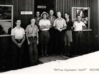
photograph - Fortuna - 1st Year of Army Occupation in Bendigo, 1942
... Benny Jack Williams at Fortuna, Bendigo. Accommodation tents were erected above the lake, which later became the parade ground. .5) - Photo, black & white, 1942. ...Note the state of the gardens.’ .4) - Annotated on back ‘Benny Jack Williams Fortuna Bendigo. Tents were erected where present day parade ground is above the lake.’ .5) - Annotated on back ‘Working dress - Giggle suits. ...Benny Jack Williams at Fortuna, Bendigo. Accommodation tents were erected above the lake, which later became the parade ground. .5) - Photo, black & white, 1942. ...This is a set of 17 photographs taken during the first year of Army occupation at Fortuna, Bendigo in 1942. The photos provide an insight into the preparatory work performed on the Fortuna Villa and surrounding buildings, by the Working Party 5th Army Troop and Ordnance Training Depot, before its occupation by personnel from LHQ Cartographic Company, Royal Australian Survey Corps. The annotation on the back of Photos .9P and .10P is misspelt. The correct spelling is ‘Nell Gwynne’. The poppet head of the Central Nell Gwynne mine is still an iconic landmark in Bendigo, lying just down the road from the poppet head lookout at Victoria Hill. The Central Nell Gwynne was the premier mine of Bendigo's 1930s mining revival and is of high historical value, due to the extensive and relatively intact features which remain at the site. The annotation on the back of Photo .17P is incorrect. The location of HQ 5th Army Troop was ‘Reynard St, Coburg.’ By late 1941 as Japan extended its control throughout Indo-China, resolving the accommodation problem of AHQ Cartographic Company located in Melbourne became more urgent. The steady Japanese advance made the bombing of Melbourne no longer a remote possibility, and in accordance with a general policy of dispersion, the Deputy Chief of the General Staff, Major General Sidney Rowell instructed Major William Sarll, in the interests of security of plant and to provide against possible damage of air attack, to investigate suitable safer inland accommodation for AHQ Cartographic Company. Major Sarll inspected many properties before finding one that would meet the requirements of the Cartographic Company. In late 1941, he came to inspect Fortuna, a rambling old mansion with about fifteen acres of ground in central Bendigo. Initially there was no intention to occupy the site beyond the end of the war, although Major Sarll's report to the Director of Survey noted many advantages in moving the Company to Bendigo. Major General Rowell quickly approved the selection of Fortuna before other authorities, which were investigating the evacuation of school children, could get in ahead of the Cartographic Company. On 23 March 1942, the Commonwealth of Australia, under the provisions of the National Security Act of 1939, took possession of the house, the old battery buildings and the fifteen acres of grounds. Under Warrant Officer J. Trist’s direction, over fifty Parks and Works tradesmen completed building works necessary to accommodate the Survey Corps’ military, map making and printing requirements. The building program was still under way when the first officer, Lieutenant Ralph Westgarth, arrived in May 1942 with the advance party which received and positioned all equipment as it came up from Melbourne in semi-trailers. Once the equipment was installed the rest of the Cartographic Company completed its shift to Bendigo by 11th June 1942. The first year of the Survey Corps’ occupation of Fortuna is covered in more detail with additional historic photographs, in pages 17-22 of Valerie Lovejoy’s book 'Mapmakers of Fortuna – A history of the Army Survey Regiment’ ISBN: 0-646-42120-4.This is a set of 17 photographs taken during the first year of Army Occupation at Fortuna, Bendigo in 1942. The black and white photographs were printed on photographic paper and are part of the Army Survey Regiment’s Collection. The photographs were scanned at 300 dpi. .1) - Photo, black & white, 1942. Bendigo Parks and Works tradesmen at Fortuna. L to R: Cliff Day, Ernie Arnold, Norm? .2) - Photo, black & white, 1942. “Don” - possibly SGT Don Sutcliffe. Fortuna, Bendigo. .3) - Photo, black & white, 1942. Parks and Works tradesmen in garden at Fortuna, Bendigo. L to R: Fred & Ernie. .4) - Photo, black & white, 1942. Benny Jack Williams at Fortuna, Bendigo. Accommodation tents were erected above the lake, which later became the parade ground. .5) - Photo, black & white, 1942. Working dress - Giggle suits. Parks and Works tradesmen at Fortuna, Bendigo. L to R: Cliff and Harry on big roof. .6) - Photo, black & white, 1942. Parks and Works tradesmen at Fortuna, Bendigo. Ted on big roof. .7) - Photo, black & white, 1942. Gold crusher battery just behind Fortuna. .8) - Photo, black & white, 1942. Scene of Bendigo from Fortuna. .9) - Photo, black & white, 1942. Nell Gwynne Mine from mullock heap at Victoria Hill near Fortuna, Bendigo. .10) - Photo, black & white, 1942. Nell Gwynne Mine and crusher near Fortuna, Bendigo. .11) - Photo, black & white, 1942. Sluicing for gold at Eaglehawk. .12) - Photo, black & white, 1942. Fortuna, Bendigo taken from the far side of tennis courts. .13) - Photo, black & white, 1942. Fortuna, Bendigo & its reflection from across the lake. .14) - Photo, black & white, 1942. Fortuna, Bendigo from the fishpond. .15) - Photo, black & white, 1942. Fortuna, Bendigo. .16) - Photo, black & white, 1942. First Fortuna Football Team at unknown location. L to R: 5th Bob Wright, 11th SGT Don Sutcliffe. .17) - Photo, black & white, 1942. Working Party from 5th Army Troop and Ordnance Training Depot at Fortuna, Bendigo.Some personnel are identified. Annotated with date within photos. .1) – Annotated on back ‘Cliff, Ernie, Norm, Dec ‘42. Cliff Day - dairy farmer, plasterers’ labourer. Ernie Arnold – hard plasterer. Norm? - QM Store for tools etc. QM Store was the Stables.’ .2) - Annotated on back ‘Don. Fortuna 1942’ .3) - Annotated on back ‘Fred & Ernie. Dec 1942. Carpenters. Note the state of the gardens.’ .4) - Annotated on back ‘Benny Jack Williams Fortuna Bendigo. Tents were erected where present day parade ground is above the lake.’ .5) - Annotated on back ‘Working dress - Giggle suits. June 42. Cliff and Harry on big roof. This photo was taken as the ventilating ridge was being installed on the building housing the printing machines. The machines were installed later by civilian labour when building was complete.’ .6) - Annotated on back ‘Ted on big roof Fortuna Bendigo.’ .7) - Annotated on back ‘Gold crusher battery – Bendigo for slay heap – 1942. 12 stamp battery. Just behind Fortuna. Was working at night when the “Army” came to Bendigo. Later removed to “Coolgardie - WA. Present site of Southern Cross TV.’ .8) - Annotated on back ‘Scene of Bendigo from Fortuna. June 1942.’ .9) - Annotated on back ‘Nell Gwyne Mine from mullock heap (Victoria Hill) Sept 1942.’ .10) - Annotated on back ‘Nell Gwyne Mine and crusher September 1942.’ .11) - Annotated on back ‘Sluicing for gold at Eaglehawk. August 1942.’ .12) - Annotated on back ‘Fortuna Bendigo 1942. Taken from far side of tennis courts.’ .13) - Annotated on back ‘ “Fortuna” across the lake & reflection.’ .14) - Annotated on back ‘Fortuna from fishpond June 1942.’ .15) - Annotated on back ‘Fortuna Dec 1942.’ .16) - Annotated on front ‘X’ x2. Annotated on back First Fortuna Football Team 1942‘Bob Wright’, ‘SGT Don Sutcliffe’. .17) - Annotated ‘Working Party at Fortuna before one of the drafts’, Working Party 5th Army Troop and Ordnance Training Depot Showgrounds, now the Sportsground Bendigo’, ‘HQ of 5th Army Troop was Reynards Rd, Coburg.’royal australian survey corps, rasvy, army survey regiment, army svy regt, fortuna, asr -
 Eltham District Historical Society Inc
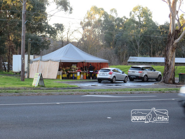
Photograph, Liz Pidgeon, Heritage Excursion; Eltham Lower Park Walk and Talk, 1 July 2017, 1 July 2017
... ...tent...Temporary flower vendor set up in a tent opposite Eltham Lower Park. The flower seller sets up on weekends and offers a convenient drive through service for customers. ...Eltham District Historical Society Inc 728 Main Rd Eltham melbourne Temporary flower vendor set up in a tent opposite Eltham Lower Park. The flower seller sets up on weekends and offers a convenient drive through service for customers. ...Temporary flower vendor set up in a tent opposite Eltham Lower Park. The flower seller sets up on weekends and offers a convenient drive through service for customers. Goolge maps in February 2021 identified this site as Fleur De Feliss Roadside Store. Heritage Excursion - Saturday 1st July - Eltham Lower Park - Walk and Talk Eltham Lower Park has played an important part in the history of our area since the early days of European settlement when it was used by local residents as an informal racecourse. Prior to that its location at the junction of the Diamond Creek and the Yarra River made it an important meeting place for the Wurundjeri people. The park combines formal elements and sporting facilities with remnant bushland that is of environmental significance. It is home to sporting and horse riding clubs, popular play spaces and the Diamond Valley Miniature Railway, which attracts large numbers of visitors. The park will be the venue for our July excursion which will comprise a walk of about 3.5 km around the park and adjacent areas. Along the way we will discuss the history and natural history of the area. The path along the creek and the river provides a pleasant and scenic walk. This walk on Saturday 1st July is about 3.5 km in length and will take 2 to 2.5 hours. It will start at 2pm at the Main Road car park at the front of the park. (Melway ref 21 H 10). Newsletter No., 234, June 2017 Born Digitalheritage excursion, activities, eltham district historical society, eltham lower park, roadside store, flower vendor, fleur de feliss, tent, drive through, drive thru -
 Eltham District Historical Society Inc
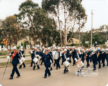
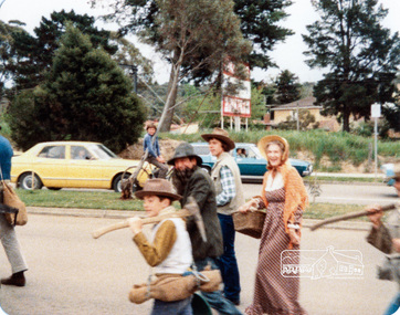
Photograph, Victorian Police Marching Band, Eltham Festival Parade, 16 October 1982, 16/10/1982
... This has prompted the suggestion for future parades that we have a tent or other suitable venue for members to gather after the event. ...This has prompted the suggestion for future parades that we have a tent or other suitable venue for members to gather after the event. ...[article in EDHS Newsletter No. 27, November 1982:] 1982: 16-17 October. “Pioneers of Eltham” and tractor (rain). Although our parade entry did not win a prize this year, it was considered highly successful from a participation point of view. Despite some uncertainty as to just who was coming, members and friends kept appearing at the assembly area. As in the past years our friends from the Victorian Folk Music Club brought their instruments along and really added to the occasion. This year we concentrated on a rural theme with a tractor/trailer combination. Thanks to Peter Bassett-Smith for the tractor, Joh Ebeli for the decorations and friendly trailer owner Dennis McKay. Unfortunately the closing stages of the parade were marred by heavy rain. We just finished as the rain started but members scattered very quickly. This has prompted the suggestion for future parades that we have a tent or other suitable venue for members to gather after the event. This is worth following up. The cold driving rain provided a special problem for Peter in driving his tractor home to Kangaroo Ground. Have you ever had to choose between standing up to warm your hands on the exhaust and having your tractor seat flooded? Certificate, Festival Parade Award, Rotary Club of Eltham, Eighth Eltham Community Festival 1982: Presented to the Shire of Eltham Historical Society for the most effort by "locals".Colour photographmain road, eltham festival, eltham, eltham parade, festivals, parade, parade floats, 1982, marching band, victorian police -
 Eltham District Historical Society Inc
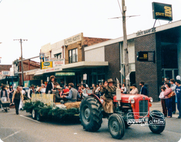
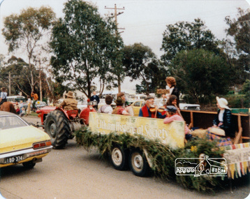
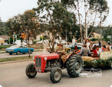
Photograph, Society member Peter Bassett-Smith towing the Shire of Eltham Historical Society float with his tractor in the Eltham Festival Parade along Main Road, 16 October 1982, 16/10/1982
... This has prompted the suggestion for future parades that we have a tent or other suitable venue for members to gather after the event. ...This has prompted the suggestion for future parades that we have a tent or other suitable venue for members to gather after the event. ...[article in EDHS Newsletter No. 27, November 1982:] 1982: 16-17 October. “Pioneers of Eltham” and tractor (rain). Although our parade entry did not win a prize this year, it was considered highly successful from a participation point of view. Despite some uncertainty as to just who was coming, members and friends kept appearing at the assembly area. As in the past years our friends from the Victorian Folk Music Club brought their instruments along and really added to the occasion. This year we concentrated on a rural theme with a tractor/trailer combination. Thanks to Peter Bassett-Smith for the tractor, Joh Ebeli for the decorations and friendly trailer owner Dennis McKay. Unfortunately the closing stages of the parade were marred by heavy rain. We just finished as the rain started but members scattered very quickly. This has prompted the suggestion for future parades that we have a tent or other suitable venue for members to gather after the event. This is worth following up. The cold driving rain provided a special problem for Peter in driving his tractor home to Kangaroo Ground. Have you ever had to choose between standing up to warm your hands on the exhaust and having your tractor seat flooded? Certificate, Festival Parade Award, Rotary Club of Eltham, Eighth Eltham Community Festival 1982: Presented to the Shire of Eltham Historical Society for the most effort by "locals".Colour photographmain road, eltham festival, eltham, eltham parade, festivals, parade, parade floats, 1982, eltham district historical society, peter bassett-smith, shire of eltham historical society -
 Eltham District Historical Society Inc
Photograph, Shire of Eltham Historical Society float, Eltham Festival Parade, 16 October 1982, 16/10/1982
... This has prompted the suggestion for future parades that we have a tent or other suitable venue for members to gather after the event. ...This has prompted the suggestion for future parades that we have a tent or other suitable venue for members to gather after the event. ...[article in EDHS Newsletter No. 27, November 1982:] 1982: 16-17 October. “Pioneers of Eltham” and tractor (rain). Although our parade entry did not win a prize this year, it was considered highly successful from a participation point of view. Despite some uncertainty as to just who was coming, members and friends kept appearing at the assembly area. As in the past years our friends from the Victorian Folk Music Club brought their instruments along and really added to the occasion. This year we concentrated on a rural theme with a tractor/trailer combination. Thanks to Peter Bassett-Smith for the tractor, Joh Ebeli for the decorations and friendly trailer owner Dennis McKay. Unfortunately the closing stages of the parade were marred by heavy rain. We just finished as the rain started but members scattered very quickly. This has prompted the suggestion for future parades that we have a tent or other suitable venue for members to gather after the event. This is worth following up. The cold driving rain provided a special problem for Peter in driving his tractor home to Kangaroo Ground. Have you ever had to choose between standing up to warm your hands on the exhaust and having your tractor seat flooded? Certificate, Festival Parade Award, Rotary Club of Eltham, Eighth Eltham Community Festival 1982: Presented to the Shire of Eltham Historical Society for the most effort by "locals".Colour photographmain road, eltham festival, eltham, eltham parade, festivals, parade, parade floats, 1982, eltham district historical society, shire of eltham historical society -
 Eltham District Historical Society Inc
Photograph, Society member Peter Bassett-Smith towing the Shire of Eltham Historical Society float with his tractor in the Eltham Festival Parade along Main Road, 16 October 1982, 16/10/1982
... This has prompted the suggestion for future parades that we have a tent or other suitable venue for members to gather after the event. ...This has prompted the suggestion for future parades that we have a tent or other suitable venue for members to gather after the event. ...[article in EDHS Newsletter No. 27, November 1982:] 1982: 16-17 October. “Pioneers of Eltham” and tractor (rain). Although our parade entry did not win a prize this year, it was considered highly successful from a participation point of view. Despite some uncertainty as to just who was coming, members and friends kept appearing at the assembly area. As in the past years our friends from the Victorian Folk Music Club brought their instruments along and really added to the occasion. This year we concentrated on a rural theme with a tractor/trailer combination. Thanks to Peter Bassett-Smith for the tractor, Joh Ebeli for the decorations and friendly trailer owner Dennis McKay. Unfortunately the closing stages of the parade were marred by heavy rain. We just finished as the rain started but members scattered very quickly. This has prompted the suggestion for future parades that we have a tent or other suitable venue for members to gather after the event. This is worth following up. The cold driving rain provided a special problem for Peter in driving his tractor home to Kangaroo Ground. Have you ever had to choose between standing up to warm your hands on the exhaust and having your tractor seat flooded? Certificate, Festival Parade Award, Rotary Club of Eltham, Eighth Eltham Community Festival 1982: Presented to the Shire of Eltham Historical Society for the most effort by "locals".Colour photographmain road, eltham festival, eltham, eltham parade, festivals, parade, parade floats, 1982, eltham district historical society, shire of eltham historical society, peter bassett-smith -
 Eltham District Historical Society Inc
Photograph, Eltham Festival Parade, 16 October 1982, 16/10/1982
... This has prompted the suggestion for future parades that we have a tent or other suitable venue for members to gather after the event. ...This has prompted the suggestion for future parades that we have a tent or other suitable venue for members to gather after the event. ...[article in EDHS Newsletter No. 27, November 1982:] 1982: 16-17 October. “Pioneers of Eltham” and tractor (rain). Although our parade entry did not win a prize this year, it was considered highly successful from a participation point of view. Despite some uncertainty as to just who was coming, members and friends kept appearing at the assembly area. As in the past years our friends from the Victorian Folk Music Club brought their instruments along and really added to the occasion. This year we concentrated on a rural theme with a tractor/trailer combination. Thanks to Peter Bassett-Smith for the tractor, Joh Ebeli for the decorations and friendly trailer owner Dennis McKay. Unfortunately the closing stages of the parade were marred by heavy rain. We just finished as the rain started but members scattered very quickly. This has prompted the suggestion for future parades that we have a tent or other suitable venue for members to gather after the event. This is worth following up. The cold driving rain provided a special problem for Peter in driving his tractor home to Kangaroo Ground. Have you ever had to choose between standing up to warm your hands on the exhaust and having your tractor seat flooded? Certificate, Festival Parade Award, Rotary Club of Eltham, Eighth Eltham Community Festival 1982: Presented to the Shire of Eltham Historical Society for the most effort by "locals".Colour photographmain road, eltham festival, eltham, eltham parade, festivals, parade, parade floats, 1982