Showing 92435 items matching " victoria"
-
 Greensborough Historical Society
Administrative record - Compact disc, Victoria: births, deaths, marriages: [1836-1985]
Victorian births, deaths and marriages (B.D.M.) Each disc contains records for Victoria: Disc 1 Victorian Edwardian index 1902-1913; Disc 2 Great War index, B.D.M. 1914-1920; Disc 3 Victorian deaths 1921-1985; Disc 4 Victorian marriage index 1921-1942 ; Disc 5 Victorian pioneers; Disc 6: Victorian Federation B.M.D. 1889-1901; Disc 7 Victorian pioneer index 1837-1888; Disc 8 Victorian archives. This set also known as the Digger Database.A database of vital records (births, deaths, marriages) from South Australia.9 x compact discs in plastic casesContents listed on each CDgenealogy resources, family history, registers of births deaths marriages, victoria, digger database -
 Myrtleford and District Historical Society
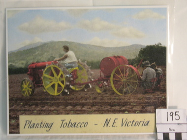
Colourized Photograph, "Planting Tobacco N.E. Victoria
The photograph depicts the 2nd important stage in tobacco growing--transplanting seedlings into open paddocks. It depicts early post-war machinery in use at the time until affordable modern tractors were available. The planting machine has probably been adapted from the horse-drawn era pre-World War 2. The scene is one near Myrtleford in the Ovens Valley.The photograph depicts the slow adaptation of modern tobacco farming methods in the immediate post-war period and the type of terain suitable for tobacco growing. The labour intensive nature of tobacco planting is also depicted.A colourized photograph of tobacco planting activity in a paddock near Myrtleford.Inscription: Planting Tobacco N.E. Victoria"tobacco farming tobacco planting machinery -
 Uniting Church Archives - Synod of Victoria
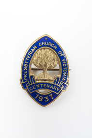
Lapel Badge, Presbyterian Church of Victoria Centenary 1937
This badge was worn by thousands of people during the year of 1937.5 Oval shaped gold metal and blue enamel badges"Presbyterian Church of Victoria Centenary 1937"presbyterian church of victoria centenary, presbyterian -
 Ballarat Heritage Services
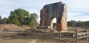
Photograph, Grand Duke Mine, Timor, Victoria, 04/05/2025
Running through this reserve was one of Victoria's richest gold deep leads. From 1869 to 1896 this mine produced 216,000 ounces of gold, valued at over £885,000. The Timor area was mainly mined by the Duke and Timor Gold Mining Company, later known as Duchess of Timor, Duke, and Grand Duke. On 03 May 1869, at a traditional afternoon ceremony, the machinery was started and launched by the old process of 'giving it a name'. A baptismal ceremony was performed, with a Miss Eliza Watson dashing a bottle of champagne over the fly wheel on its first revolution and proclaiming its name to be 'The Galatea'. The mine here was renowned for the massive pumping engine it boasted. Imported from England, the massive Cornish pump was an improvement that was added in 1874. It had a 30 ton iron beam. The mine was the economic centre of this area, employing hundreds of men over its 27 years. At the height of its operation the company's proprietors boasted that nearly all the inhabitants of the nearby towns of Timor and Bowenvale depended on the mine for support. There were some tumultuous times at the mine, with periods of financial strife as well as accidents. When the pumps broke down in 1879 the mine flooded and remained out of action for two years. Mining was a dangerous occupation and a tragic accident in December 1883 claimed the lives of four men. As the ground here was so wet, pumping water out of the mine was crucial to safely reach the gold. It was this pumping engine, reported to be the largest of its kind in Australia, and comparable in size to just two others in the world, that was the key to the success of the Grand Duke mine. Many other smaller nearby mines also had their water pumped out. During the last seven years of the mine's operation it pumped out 2,000 gallons of water every minute, making this the longest and most continuous wet mine in the state. As well as the pump house and engine, there were four main shafts, 12 Cornish flue boilers, eight iron puddling machines and one battery of 20 heads. A massive pumping engine The arch before you is all that remains of the pump house that served to remove water from this mine. When mining started at Timor in the late 1860s the ground here was very wet. If miners were to have any success in reaching the gold they had to remove the water from the ground. To deal with this challenge the company imported a massive Cornish pumping engine from England to pump water out of the mine. It was reputed to be one of the best pumping engines in the world at the time. The engine generated 270 horsepower and its iron beam, weighing 30 tons, was the largest in Victoria. The beam of the large pumping engine see-sawed on this pump house wall to move the plunger or bucket in the pump up and down. The vertical cylinder was 80 inches in diameter with a stroke of 10 feet. The piston itself was eight inches in diameter and 17 feet high and the piston pump had a diameter of 22 inches. For such large engines a massive wall to support the beam was necessary. The piston operated on the downstroke and consequently the cylinder had to be anchored to a considerable foundation to overcome the weight of the pump rods in the shaft. The whole apparatus had to be contained in a tall building because of its vertical configuration. The pumping engine's building has beam walls six feet wide and over 26 feet long which rest on foundations 16 feet deep. The granite used to construct the arch was quarried at Mt Hooghly, some eight or nine kilometres away.Colour photographs of the Grand Duke Mine at Timor near Maryborough, Victoria.grand duke mine, timor, maryborough, mining, duke and timor gold mining company, duchess of timor -
 Federation University Historical Collection
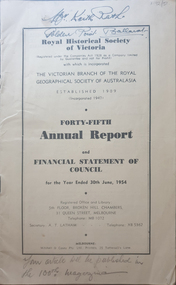
Booklet, Royal Historical Society of Victoria 45th Annual Report and Financial Statement of Council, 06/1954
The RHSV was established in 1909.14 page annual report of the Royal historical Society of VictoriaFront cover "Mr Keith Rash Golden Point Ballarat" "Your article will be published in the 100th magazine".royal historical society of victoria, annual report -
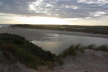 Victorian Interpretive Projects Inc.
Photographs - Colour, Killarney Beach, Victoria, 2014, 13/09/2014
Killarney beach is in close proximity to Port Fairy and Koroit,A number of colour photographs showing scenes of Killarney Beach, Victoria.killarney, beach -
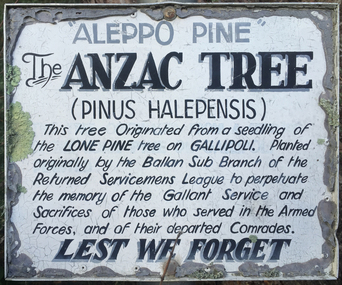 Victorian Interpretive Projects Inc.
Photograph - Colour, Clare Gervasoni, Lone Pine at Ballan, Victoria, 2015
Three photographs relating to a Lone Pine planted at Ballan Victoriaballan, world war, world war one, lone pine, gallipoli, mmm -
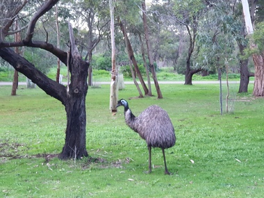 Ballarat Heritage Services
Photograph - Digital photographs, Clare Gervasoni, Emus at Tower Hill near Koroit, Victoria, 29/06/2020
Digital images of emus on Tower Hill near Koroit, Victoriakoroit, moyne shire, volcano, maar, game reserve, tower hill, tower hill, emu, wildlife, native, bird, flightless -
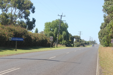 Ballarat Heritage Services
Photograph - Colour, Clare Gervasoni, Southern Cross, Victoria, 2019, 01/01/2019
A number of photographs of the main road through Southern Cross, Victoria. southern cross -
 Ballarat Heritage Services
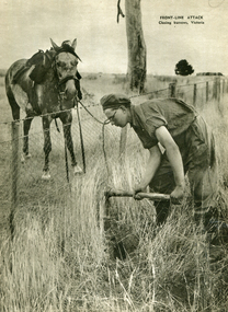
Image - Black and White, Closing Rabbit Burrows, Victoria, c1950, c1950
A black and white image of a person closing of a rabbit burrow in Victoria . vermin, rabbit, rabbit burrows -
 Ballarat Heritage Services
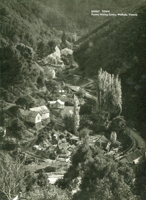
Image - Black and White, Walhalla, Victoria, c1950, c1950
A black and white image of the former mining town in Victoria - Walhalla.walhalla, mining -
 Ballarat Heritage Services
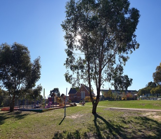
Photograph - Photograph - Colour, Clare Gervasoni, Magpie Primary School, Victoria, 2019, 18/05/2019
The red brick Magpie Primary School opened on 31 May 1880.Colour photographs of the Magpie Primary School near Ballarat, Victoria. magpie, magpie primary school, education, magpie state school -
 Ballarat Heritage Services
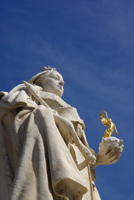
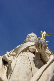
Photograph - Colour, Queen Victoria Statue, Sturt Street, Ballarat, 2011, 29/12/2011
Colour photograph of the Queen Victoria Statue in Sturt Street, Ballarat. sturt street ballarat, christmas tree, pioneer women, ballarat, plaque, queen victoria -
 Ballarat Heritage Services
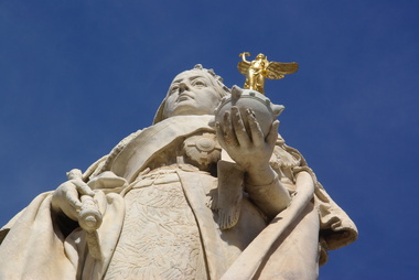
Photograph - Colour, Queen Victoria Statue, Sturt Street, Ballarat, 2011, 29/12/2011
Colour photograph of the Queen Victoria Statue in Sturt Street, Ballarat. sturt street ballarat, christmas tree, pioneer women, ballarat, plaque, queen victoria -
 Ballarat Heritage Services
Photograph - Colour, Queen Victoria Statue, Sturt Street, Ballarat, 2011, 29/12/2011
Colour photograph of the Queen Victoria Statue in Sturt Street, Ballarat. sturt street ballarat, christmas tree, pioneer women, ballarat, plaque -
 Ballarat Heritage Services
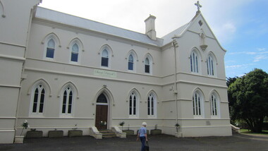
Photograph - Digital photographs, L.J. Gervasoni, Former St Patrick's Convent, Koroit, Victoria, 2015
Digital images of the former St Patrick's Convent, Koroit, Victoria. koroit, moyne shire, st patrick's convent, st patrick, convent, catholic, religion, stained glass -
 Ballarat Heritage Services
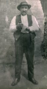
Photograph - Photograph - Black and White, John Rodger Hogan of Kurting, Victoria
Black and white photo of John Rodger Hogan of Kurting, Victoria.john rodger hogan, john r. hogan, kurting -
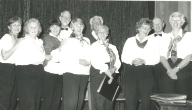 Lakes Entrance Historical Society
Photograph, Lakes Post Newspaper, Metung Village Singers, Metung Victoria, May 1994
named are Bridie Christie, John Trotter, Wilma Jennings Allan Trevorrow Dorothy TrevorrowBlack and white photograph of Metung Village Singers Metung Victoriachoir, social history -
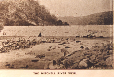 Lakes Entrance Historical Society
Photograph - Mitchell River Weir, Glenaladale Victoria, 1900 c
The Mitchell River Weir was commenced in 1900 work continued until almost completed, Foundation stone laid in March 1893 but the extensive flood damage in December 1893 ended the high hopes of the planners.Sepia toned photograph of weir on the Mitchell River at Glenaladale Victoriatopography, waterways, weir's -
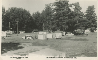 Lakes Entrance Historical Society
Postcard - Mitchell Gardens Campground Bairnsdale Victoria, Rose Series P4145, 1945 c
Site selected by Shire in 1927 fully developed by 1937 Mrs Boyes as caretakerBlack and white postcard of Mitchell Gardens Campground Bairnsdale VictoriaThe Camping Ground Bairnsdale Vicaccommodation, businesses, camping, caravan parks -
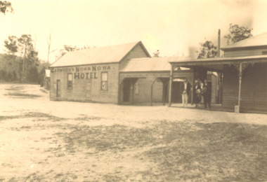 Lakes Entrance Historical Society
Photograph, Carmody's Hotel, Nowa Nowa Victoria, 1915 c
John Carmody took over the Nowa Nowa Hotel from previous lease holder David Duggan in 1914.Black and white photograph of Carmody's Hotel at Nowa Nowa Victoriamemorials, shipwrecks, hotels -
 Lakes Entrance Historical Society
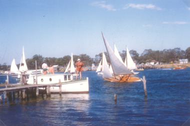
Photograph - Yacht Races, K Scarce, Paynesville Victoria, 1975 c
Taken from Paynesville jetty showing Raymond Island oppositeColour photograph taken during yacht races at Paynesville Victoria waterways, boats and boating, competitions -
 Whitehorse Historical Society Inc.
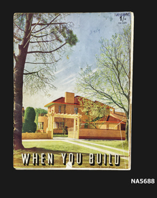
Book - When You Build, Fibrous Plaster Manufacturers' Association of Victoria, Unknown
Guide on Building a new home. Designs- Interior and exterior illustrations Presented with compliments of Fibrous Plaster manufacturers' Association of Victoria Paper book Guide to building a home Presented by Fibrous Plaster Manufacturers' Association of Victoria Coloured illustration of interior and exterior Methods of Home ConstructionWhen You Buildhome building, australia -
 City of Whittlesea
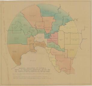
Map - Maps, Municipal Association Of Victoria groupings of councils for representation, 1936
Map was produced as part of Municipal Association of Victoria report on Metropolitan Government, 18 May 1936. Map shows proprosed groupings of municipalities for election of representation to the MAV Board. Map includes net annual value of rateable property within each municipality. The net rateable value for metropolitan area of the Shire of Whittlesea in 1936 was £20,102. Maps, paper. Produced as part of Municipal Association of Victoria report on Metropolitan Government, 18 May 1936. Map shows proprosed groupings of municipalities for election of representation to the MAV Board. council, municipal association of victoria -
 Flagstaff Hill Maritime Museum and Village
Book, Acts of Parliament of Victoria 33 & 34
Acts of Parliament of Victoria 33 & 34 Victoria 1870 Publisher: Government Printer Melbourne Date: 1871warrnambool, shipwrecked-coast, flagstaff-hill, flagstaff-hill-maritime-museum, maritime-museum, shipwreck-coast, flagstaff-hill-maritime-village, shipwrecked-artefact, great ocean road, book, warrnambool library, warrnambool mechanics’ institute, mechanics’ institute library, victorian library board, warrnambool books and records, warrnambool children’s library, warrnambool public library, acts of parliament of victoria 33 & 34 -
 Marysville & District Historical Society
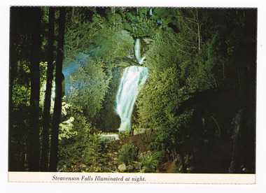
Postcard (item) - Colour postcard, Nucolorvue Productions Pty. Ltd, Steavenson Falls Illuminated at night, Pre 2009
A colour photograph of Steavenson Falls in Marysville in Victoria, illuminated at night.A colour photograph of Steavenson Falls in Marysville in Victoria, illuminated at night. The Steavenson Falls is named after the Victorian Assistant Commissioner of Roads and Bridges, John Steavenson who arrived in Victoria in the early 1860s. This postcard was produced by Nucolorvue Productions Pty. Ltd. as a souvenir of Marysville.NU-COLOR-VUE/ OF/ AUSTRALIA MARYSVILLE, VICTORIA. The Steavenson Falls illuminated at Night by its own hydro-electric/ power. (Ministry of Tourism and Forests/ Commission of Victoria) PLACE/ STAMP/ HERE POST CARD NCV.167 - NUCOLORVUE PRODUCTIONS PTY. LTD./ COPYRIGHT Printed in Australiamarysville, steavenson falls, victoria, postcard, nucolorvue productions, souvenir, john steavenson -
 Lakes Entrance Historical Society
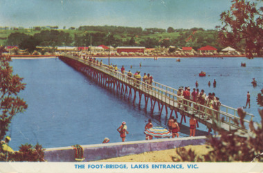
Photograph - Cunninghame Arm footbridge Lakes Entrance Victoria. c1955, Rose Series, 1955 c
Cunninghame Arm footbridge showing crowd on bridge, cars parked on Esplanade, new concrete wall between dunes and lake at south end of bridge Lakes Entrance Victoria. c1955. Also another colour postcard similar view of footbridge made by Murray Views donor Susan Samuel 2 January 2015 number 04272.1, 9 x 14 cmColour postcard taken from south end of the Cunninghame Arm footbridge showing crowd on bridge, cars parked on Esplanade, new concrete wall between dunes and lake at south end of bridge Lakes Entrance Victoria. c1955. Also another colour postcard similar view of footbridge The Foot-Bridge, Lakes Entrance. Vicrecreation, waterfront, land reclamation, gippsland lakes -
 Surrey Hills Historical Society Collection
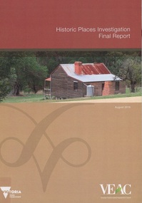
Book, Historic Places Investigation, Aug-16
In March 2014, the then Minister for Environment and Climate change requested the Victorian Environmental Assessment Council (VEAC) to undertake an investigation into historic places on public land across Victoria. This final report completes VEAC's investigation.In March 2014, the then Minister for Environment and Climate change requested the Victorian Environmental Assessment Council (VEAC) to undertake an investigation into historic places on public land across Victoria. This final report completes VEAC's investigation.historiic buildings - victoria, historic sites - victoria, public lands - victoria, veac -
 Marysville & District Historical Society
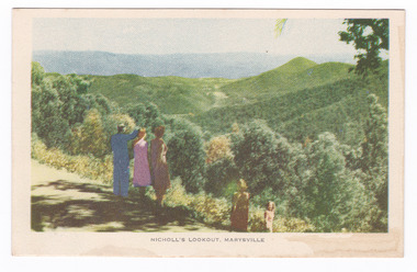
Postcard (item) - Colour tinted postcard, Nucolorvue Productions, Nicholl's Lookout, Marysville, 1950's
An early colour photograph of the view of Marysville in Victoria taken from Nicholl's Lookout.An early colour photograph of the view of Marysville in Victoria taken from Nicholl's Lookout. Nicholl's Lookout is situated on the Marysville-Wood's Point Road. The Marysville-Woods Point Road was originally part of the Yarra Track, constructed in the early 1860s to provide access between Healesville and the Woods Point Goldfields. Despite the steep terrain and engineering difficulties, the Yarra Track soon became a busy route used by pack horses, horse-drawn drays, and wagons. Today this sealed mountain road is a popular scenic drive between Marysville and Warburton. This postcard was produced by Nucolorvue Productions in Elwood, Victoria as a souvenir of Marysville.POST CARD NUCOLORVUE PRODUCTIONS, ELWOOD, VICTORIAnicholl's lookout, marysville, victoria, nucolorvue productions, postcard, souvenir, marysville-wood's point road, yarra track, mining, warburton -
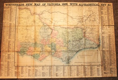 Wodonga & District Historical Society Inc
Map - Whiteheads New Map of Victoria, E. Whitehead & Co., engravers & lithographers, 1868
Edward Whitehead was a printer and publisher active in Melbourne during the latter half of the 19th century. Whitehead founded his printing business at 67 Collins Street East in 1864 and, though not focused on maps, began publishing his own series of maps of Victoria in 1867. He focussed on producing highly detailed folding maps of Victoria which included a very detailed index of place names. His series of maps of Victoria became one of the most successful and most profitable series of regional maps of Australia ever produced.This is a very early map of Victoria showing Belvoir (Wodonga)A detailed early map of Victoria with counties clearly marked and shaded and a detailed index. It also shows roads, post office towns, railways, telegraphs, gold mining areas and notes on topography. Relief shown by hachures and spot heights. Includes a list of towns with distances from Melbourne on 3 sides of map. It is produced on paper mounted on linen.victoria cartography, rare maps victoria, whiteheads maps