We acknowledge the Traditional Owners of the place now called Victoria, and all First Peoples living and working on this land.
We celebrate the history and contemporary creativity of the world’s oldest living culture and pay respect to Elders — past, present and future.
Please be aware that this website may contain culturally sensitive material — images, voices and information provided by now deceased persons.
Content also may include images and film of places that may cause sorrow.
Aboriginal and Torres Strait Islander people are advised that this website may contain culturally sensitive material — images, voices and information provided by now deceased persons. Content also may include images and film of places that may cause sorrow.
Some material may contain terms that reflect authors’ views, or those of the period in which the item was written
or recorded but may not be considered appropriate today. These views are not necessarily the views of Victorian Collections.
Users of this site should be aware that in many areas of Australia, reproduction of the names and photographs of deceased people is restricted during a period of mourning. The length of this time varies and is determined by the community.
Reuse of any Aboriginal or Torres Strait Islander material on this site may require cultural clearances. Users are advised to contact the source organisation to discuss appropriate reuse.
Map - Maps, Municipal Association Of Victoria groupings of councils for representation, 1936
Untitled image
Reuse this media
Can you reuse this media without permission?No (with exceptions, see below)
Conditions of use
All rights reserved
This media item is licensed under "All rights reserved". You cannot share (i.e. copy, distribute, transmit) or rework (i.e. alter, transform, build upon) this item, or use it for commercial purposes without the permission of the copyright owner. However, an exception can be made if your intended use meets the "fair dealing" criteria. Uses that meet this criteria include research or study; criticism or review; parody or satire; reporting news; enabling a person with a disability to access material; or professional advice by a lawyer, patent attorney, or trademark attorney.
Attribution
Please acknowledge the item’s source, creator and title (where known)
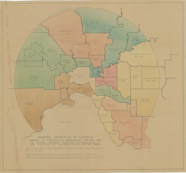
Map was produced as part of Municipal Association of Victoria report on Metropolitan Government, 18 May 1936. Map shows proprosed groupings of municipalities for election of representation to the MAV Board.
Map includes net annual value of rateable property within each municipality. The net rateable value for metropolitan area of the Shire of Whittlesea in 1936 was £20,102.
Physical description
Maps, paper. Produced as part of Municipal Association of Victoria report on Metropolitan Government, 18 May 1936. Map shows proprosed groupings of municipalities for election of representation to the MAV Board.
Victorian Collections acknowledges the Australian Aboriginal and Torres Strait Islander
peoples as the first inhabitants of the nation and the traditional custodians of the lands
where we live, learn and work.