Showing 2559 items
matching aerial
-
 Glenelg Shire Council Cultural Collection
Photograph - Photograph - Portland Harbour, n.d
Port of Portland AuthorityBack: harb023- pencilport of portland archives, portland harbour, henty beach -
 Glenelg Shire Council Cultural Collection
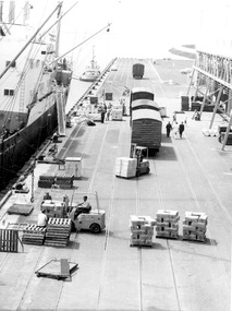
Photograph - Photograph - frozen goods loaded onto ship, n.d
Port of Portland Authority archivesFront: (no inscriptions) Back: (no inscriptions)port of portland archives, cargo, cargo handling, portland harbour -
 Glenelg Shire Council Cultural Collection
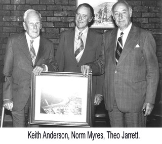
Photograph - Photograph - Keith Andersen, Norman Myers and Theo Jarrett, n.d
Port of Portland Authority archivesFront: (no inscriptions) Back: Commissioner/ Keith Andersen Norm Myers Theo Jarrett/ Chairman (blue pen, lower centre)port of portland authority archives -
Glenelg Shire Council Cultural Collection
Photograph - Photograph - View of Pivot fertiliser works, c. 1972
Port of Portland Authority archives.Front: (no inscriptions) Back: PIVOTport of portland archives -
Glenelg Shire Council Cultural Collection
Photograph - Photograph - Lawrence Rocks, n.d
Port of Portland Authority Archivesport of portland archives -
 National Vietnam Veterans Museum (NVVM)
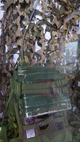
Functional Object, Field Radio
Olive green metal radio with handset and aerial. Amp CR 25 Radiobackpack radio, radio field -
Port Melbourne Historical & Preservation Society
Photograph - Aerial view of J Kitchen & Sons site, Ingles Street, Port Melbourne, 1930
Overhead -aerial - photo of J Kitchen & Sons factories with Football ground at rearsport - australian rules football, sport - cricket, industry, j kitchen & sons pty ltd -
 National Vietnam Veterans Museum (NVVM)
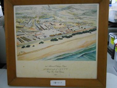
Print, Framed Lithograph, 2nd Advanced Ordinance Depot
Framed Lithograph of Aerial Drawing of 2nd Advanced Ordinance Depot Vung Tauframed lithograph, 2nd advanced ordinance depot, 1 alsg, vung tau -
 Robin Boyd Foundation
Slide, Commercial, 1956-1957
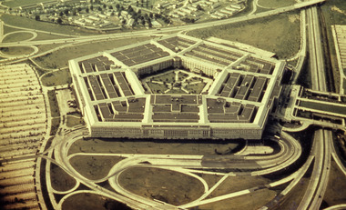
Robin Boyd developed a close friendship with the founder of the Bauhaus in Weimar Germany, Walter Gropius, who had moved to the USA in the 1930s. Through this connection, Boyd was invited to be the Massachusetts Institute of Technology (MIT) Bemis Professor at the School in the North American academic year 1956-7. Robin and Patricia Boyd, with their youngest daughter Suzy, were based in Cambridge, Massachusetts for the year. Boyd gave some lectures at MIT and he was also invited to give lectures at many other universities, allowing him to travel widely within the USA, especially on the East Coast. This gave him the opportunity to meet architects like Frank Lloyd Wright, Eero Saarinen, Paul Rudolph and many others, and visit the offices of Skidmore, Owings and Merrill, and places like Taliesin and the General Motors Technical Center Detroit. On the way home, the Boyds visited London, Berlin, Paris and Le Corbusier’s Ronchamp Chapel in France.Colour slide in a mount. Aerial photograph, Pentagon (1943), Arlington, Virginia, USAThe Pentagon / Washington DC / D / RB (All Handwritten)mit bemis professorship, mit, robin boyd, slide -
 Robin Boyd Foundation
Slide, Robin Boyd, 1966
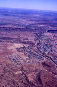
Robin Boyd was appointed Exhibits Architect for the Australian Pavilion at Expo ‘67 in Montreal. In 1966 Boyd travelled to Far North Queensland and the Northern Territory for research – the Expo exhibits included a coral display, a large rock feature made from Australian sandstone and a native plant garden.Colour slide in a mount. Aerial view of Alice Springs, Northern Territory, AustraliaMade in Australia / 10 / DEC 66M4australia, slide, robin boyd -
 Robin Boyd Foundation
Slide, Robin Boyd, 1966
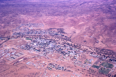
Robin Boyd was appointed Exhibits Architect for the Australian Pavilion at Expo ‘67 in Montreal. In 1966 Boyd travelled to Far North Queensland and the Northern Territory for research – the Expo exhibits included a coral display, a large rock feature made from Australian sandstone and a native plant garden.Colour slide in a mount. Aerial view of Alice Springs, Northern Territory, AustraliaMade in Australia / 11 / DEC 66M4northern territory, slide -
 Peterborough History Group
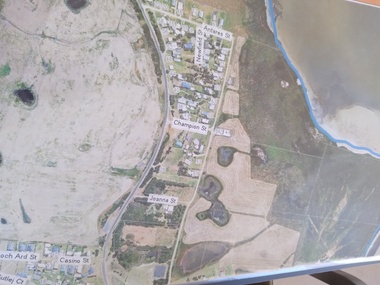
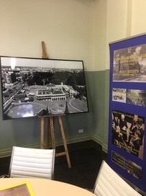
Plan - Moyne Shire Council Aerial photograph, Department of Sustainability and Environment, January 2018
View shows development at the time and showing the town boundary using Vicmap InformationSignificant in that it provides a record of the current state of development of the town. Also, a view of the estuary at that time.A3 size copy of an aerial view of the majority of the town with street names mentioned. curdies river inlet, peterborough, aerial view -
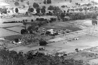 Stawell Historical Society Inc
Photograph, Cox’s Orchard at Mt Cassell in Pomonal
Cox’s Orchard from Mt Cassell at Springtime Pomonal.Black and white aerial view of property with orchards and cleared paddocks. In the background is a roadway.Taken from Mt Cassell Vicinity Cove Rock. Telephoto. Cox property.stawell -
Whitehorse Historical Society Inc.
Map, Whitehorse Road, Blackburn, 1970
Enlarged aerial photograph of area around intersection of Whitehorse and Middleborough Roads, BlackburnEnlarged aerial photograph of area around intersection of Whitehorse and Middleborough Roads, BlackburnEnlarged aerial photograph of area around intersection of Whitehorse and Middleborough Roads, Blackburnwhitehorse road, blackburn, middleborough road, blackburn, maroondah highway, box hill, aerial photographs -
Whitehorse Historical Society Inc.
Map, Canterbury Road, Blackburn, 1972
Enlarged aerial photograph of area around the intersection of Canterbury and Middleborough Roads, Blackburn.Enlarged aerial photograph of area around the intersection of Canterbury and Middleborough Roads, Blackburn.Enlarged aerial photograph of area around the intersection of Canterbury and Middleborough Roads, Blackburn.canterbury road, blackburn, middleborough road, blackburn, box hill, craig street, blackburn, hirst street, blackburn, aerial photographs -
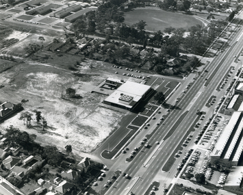
Whitehorse Historical Society Inc.
Map, Blackburn Road, Blackburn, 1970
Enlarged aerial photograph of area around the intersection of Blackburn and Canterbury Roads, Blackburn.Enlarged aerial photograph of area around the intersection of Blackburn and Canterbury Roads, Blackburn.Enlarged aerial photograph of area around the intersection of Blackburn and Canterbury Roads, Blackburn.canterbury road, blackburn, blackburn road, blackburn, rosslyn street, blackburn south, masons road, blackburn, lavelle street, blackburn, vernon street, blackburn, wirreanda court, blackburn, aerial photographs -
Whitehorse Historical Society Inc.
Map, Blackburn, 13/01/1977 12:00:00 AM
Enlarged aerial photograph of Blackburn Business Centre. Scale 1:150 metric.Enlarged aerial photograph of Blackburn Business Centre. Scale 1:150 metric.Enlarged aerial photograph of Blackburn Business Centre. Scale 1:150 metric.blackburn, blackburn road, blackburn, south parade, blackburn, railway road, blackburn, maroondah highway, blackburn, whitehorse road, blackburn, chapel street, blackburn, albert street, blackburn, queen street, blackburn, station street, blackburn, blackburn railway station, blackburn primary school, no. 2923, aerial photographs -
Whitehorse Historical Society Inc.
Document, Australian Tesselated Tile Co. Pty. Ltd, 1935
Aerial photograph of the Australian Tesselated Tile Co. site at Mitcham c. 1935.Aerial photograph of the Australian Tesselated Tile Co. site at Mitcham c. 1935.Aerial photograph of the Australian Tesselated Tile Co. site at Mitcham c. 1935.australian tesselated tile co. pty. ltd., aerial photographs, mitcham -
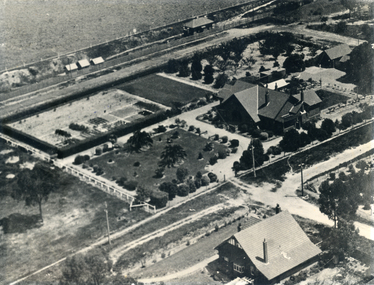
 Whitehorse Historical Society Inc.
Photograph, Nunawading Civic Centre
Black and white photo of aerial view of Nunawading Civic Centre. 1 copynunawading civic centre, whitehorse civic centre -
 Ballarat Heritage Services
Painting - Artwork, Lisa Gervasoni, Yandoit Creek Summer Oblique ,2021, 2021
Interpretation of the Gervasoni farms at Yandoit Creek using a fauvist colour palette.Lisa J. GERVASONI Born Melbourne, Victoria Graduating from Royal Melbourne Institute of Technology where she received a Bachelor of Applied Science-Planning, and the University of Melbourne with a Master of Environmental Studies Lisa Gervasoni's artwork reflects her passion for the landscape and built form. Lisa Gervasoni specialises in photography, embroidery and acrylic paintings on canvas. Many of her works have the theme of interpretation of heritage and cultural spaces. Dedicated to recording cultural heritage in situ Lisa Gervasoni has used photography to document urban areas, heritage sites and natural resources of Australia.She has provided over 70,000 images to the National Library of Australia Trove database via the Flickr portal. In 2004 Lisa Gervasoni won the Daylesford Small Art Prize for an embroidered depiction of the Savoia Hotel in Hepburn Springs, and in 2022 she was shortlisted in the Harden Landscape prize. Her art mediums are photography, embroidery and acrylic on canvas. Many of her works have a theme of interpretation of heritage and cultural spaces. abstract, modernPainted stretched canvas depicting an abstract aerial oblique of Yandoit Creek, Victoria.gervasoni farm yandoit creek, lisa gervasoni, yandoit creek, italo-australians -
 Whitehorse Historical Society Inc.
Photograph, Houses of Edgar & Stanley Walker in Mitcham
The house in the top right of the photo was built in 1922 for Edgar Walker. The house at 8 Meerut Street has been used as a hospital, and is on the Whitehorse historical register. The house in the bottom right of the photo was built c1934 for Stanley Walker, at 456 Mitcham Road, Mitcham.Black and white aerial photograph showing the Mitcham houses of Edgar and Stanley Walkerwalker, edgar edwardes, stanley, houses, mitcham road, mitcham, no.456, meerut street, no.8, heritage overlay, city of whitehorse -
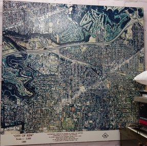 Kew Historical Society Inc
Photograph - Aerial Photograph, Division of Survey and Mapping, Department of Property and Services, City of Kew, Scale 1 : 3,000, 1989, 1989
The City of Kew was a local government area about 4 kilometres east of Melbourne, the state capital of Victoria, Australia, on the southeast bank of the Yarra River. The city covered an area of 14.56 square kilometres, and existed from 1860 until 1994.Very large aerial photograph of “City of Kew” Scale 1 : 3,000. 1989. “City of Kew” Scale 1 : 3,000. 1989. Photomosaic compiled by Division of Survey and Mapping, Department of Property and Services. © Crown (State of Victoria) Copyright 1990.city of kew, kew (vic.), aerial photography -
 St Patrick's Old Collegians Association (SPOCA)
Photograph - Buildings, Other, ACU, SPJC Room E
-
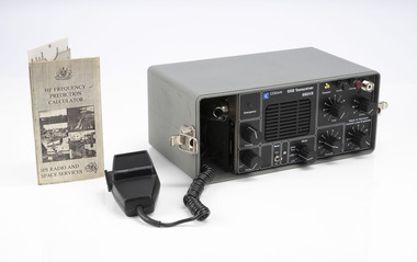 Department of Energy, Environment and Climate Action
SSB Long Range Transceiver
After the 1939 bushfires, the Forests Commission Victoria invested heavily in a radically new communications network. After suffering some inevitable delays due to the war, radio VL3AA switched into full operation in October 1945 proudly beaming out 200 watts across the State. But by today’s standards, the technology was primitive and the reception poor unless the user was on a high point somewhere. The radio signal was "line-of-sight" and bounced between fire towers and relay transmitters across the mountains back to the District offices. The advent of solid-state electronics in the 1960s replaced the more delicate valve sets which enabled greater use of vehicle mounted radios. The Commission continued to research, develop and build new radios at its many workshops around Victoria. The network was supported by a large team of skilled radio technicians. The more secure and versatile State Mobile Radio (SMR) digital trunk system came into operation in about 1995. Upgraded Tait Radios were purchased in 2014 after recommendations of the 2009 Bushfires Royal Commission. But it was the convergence of separate technologies such as 5G mobile phones, high-capacity and light-weight lithium batteries, Wi-Fi, the ever-expanding internet, cloud data storage, digital cameras, GPS, personal organisers and hundreds of supporting Apps into powerful smartphones and tablets which revolutionised bushfire communications from the mid-2000s. SSB Long Range Transceiver including aerial wire and operation card (1992)Codan SSB transceiver 6924Bbushfire, radios, forests commission victoria (fcv) -
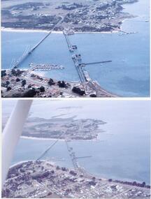 Phillip Island and District Historical Society Inc.
Photographs/Slides, Laurie Dixon, 1960's
Four of a collection of slides taken by Laurie Dixon. (Scanned by E Alexander) The new bridge was built in 1968.Four coloured photographs scanned from slides. Three aerial views. 273-01. Aerial view of the old and new bridges and Newhaven, San Remo and Churchill Island - extra close up of same photo. 273-02. Aerial view of the old and new bridges looking towards Cape Woolamai on the top right. 273-03. Aerial view of the Cowes Pier and township - extra close up of same photo. 273-04. Looking down the Cowes Pier towards the township with Isle of Wight Hotel in the background.273-03. Inscription on the slide: Cowes from the air Jan 1968.phillip island suspension bridge, two bridges phillip island, san remo, newhaven, laurie dixon, cowes pier, cowes pier phillip island -
Port Melbourne Historical & Preservation Society
Photograph - Digital images of aerial views over Station and Princes Piers, GMH and Fishermans Bend and images of Guard of Honour in March 1924, 18 Mar 1924
Guard of Honour at Princes Pier for Vice Admiral Sir Frederick FIELD, Royal Navy. Donor's father, Eric DOUGLAS is on left in front row.Two digital images of aerial views over GMH, two digital images of aerial views over Fishermans Bend, one digital image of Princes and Station Piers and two digital images of Guard of Honour in March 1924.piers and wharves - princes pier, eric douglas, sir frederick field, royal navy -
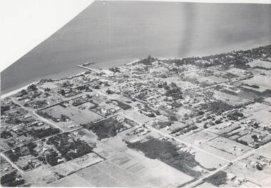 Phillip Island and District Historical Society Inc.
Photograph, Bryant West
One of a collection of over 400 photographs in an album commenced in 1960 and presented to the Phillip Island & Westernport Historical Society by the Shire of Phillip Island.Aerial photograph - panoramic view of Cowes looking north-east with Jetty and Foreshore in backgroundlocal history, photography, photographs, cowes foreshore, jetty, cowes, beaches, aerial view of cowes, aerial view of cowes phillip island, john jenner, bryant west -
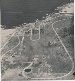 Phillip Island and District Historical Society Inc.
Photograph
One of a collection of over 400 photographs in an album commenced in 1960 and presented to the Phillip Island & Westernport Historical Society by the Shire of Phillip IslandEarly aerial photograph of the Phillip Island Motor Race Track - c. 1960'slocal history, photography, phillip island motor race track, black & white photograph, phillip island race track, john jenner, bryant west -
 Glenelg Shire Council Cultural Collection
Photograph - Photograph - Unknown cargo ship, aerial view, n.d
Port of Portland Authority archives.Front: (no inscriptions) Back: (no inscriptions)port of portland archives -
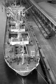 Glenelg Shire Council Cultural Collection
Photograph - Photograph - Unknown cargo ship, aerial view, n.d
Port of Portland Authority archives.Front: (no inscriptions) Back: (no inscriptions)port of portland archives