Showing 2091 items
matching bendigo maps
-
 Bendigo Historical Society Inc.
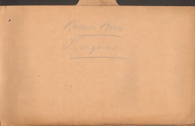
Document - MCCOLL, RANKIN AND STANISTREET COLLECTION: REIMER BROS. KINGOWER
Manilla folder containing correspondence relating to Reimer Brothers claim at Kingower, also contains a large scale parish map of Kingower showing the position of the claim and leases 6278 held by Andrew Thomas Berriman and 6279 held by Florence Adelaide BerrimanMcColl Rankin & Stanistreetgold mining, miners' safety cage, kingower/union reef mines, gold mining, kingower, reimer brothers berriman -
 Bendigo Historical Society Inc.
Document - MCCOLL, RANKIN AND STANISTREET COLLECTION: SUNDRY REPORTS, 1930's
Manilla Folder containing reports from various mines in Bendigo and surrounding areas. 1. 4 page typewritten report on the Balaclava Hill Mine at Rushworth and some newspaper clippings about the mine with a plan of the underground workings; 2. Page from the Árgus' dated 2nd August 1900 featuring an article on the survey of the Garden line of Reefs; 3. 5 page report with maps on the Tooleen Gold Field; 4. Single page report about an unnamed mining area claimed to be on the southern end of the Deborah line of reef. (this could be the 'Three Jays' mine in Sedgwick. P. Wilkin); 5. Hand written report on the Coronation Mine, 2 miles east of Walhalla.; 6. Hand written report dated 1935, of the Queen Mary mine, St. Arnaud.; 7. 1932 report on the North Neangar lease.; 8 4 page report on the Kings Prize Gold Mining Syndicate.; 9. Description of the plant of the Marong Alluvial Company? Also a guide for marking out leases.; 10. Crushing details (1 page) from the 'Enterprise' Mine South of and adjacent to Perseverence.; 11. 1 page crushing details from Rowe Brothers, Mosquito Mine, Fryerstown.; 12 hand written report mentions Arthur Hatfield, Scarsdale.; 13. Map with lines of reef showing the position of the New Moon Consolidated and the New Moon United shafts.; 14, Large scale map from Harrison/Victoria street to Havilah Road showing the positions of the Carlisle, North Garden and Unity Shafts.gold mining, miners' safety cage, sundry reports, mining. bendigo, rushworth, balaclava hill, garden line of reef, toolleen, coronation mine, walhalla, queen mary mine, st. arnaud. north neangar, kings prize gold mining syndicate, marong, enterprise mine, perseverence, rowe brothers, mosquito mine, fryerstown, arthur hatfield, scarsdale, new moon consolidate, new moon united, carlisle, north garden, unity. -
 Bendigo Historical Society Inc.
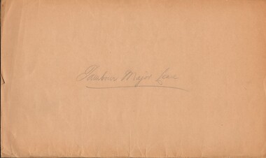
Document - MCCOLL, RANKIN AND STANISTREET COLLECTION: TAMBOUR MAJOR LEASE, 1939/1940
Manilla Folder containing Lease application and correspondence for lease No. 11007 (Tambour Major). Includes Map of lease. Also references to lease Numbers 10168 and 10899. Dated September 1939McColl Rankin & Stanistreet, Charing Cross Bendigo.gold mining, miners' safety cage, tambour major lease, gold mines, bendigo tambour major -
 Bendigo Historical Society Inc.
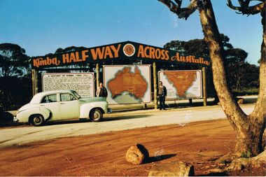
Photograph - PETER ELLIS COLLECTION: PETER ELLIS AND JOHN MEREDITH
Colour photo of Peter Ellis and John Meredith standing in front of the sign at Kimba Half Way Across Australia. There are three signs, one has the History of Kimba, one is a map of Australia and the other is a map with Spencer Gulf printed on it. A green Holden car is parked in front of the History sign.photo, group, male, peter ellis collection, peter ellis, john meredith -
 Bendigo Historical Society Inc.
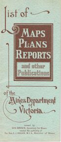
Document - LIST OF MAPS, PLANS, REPORTS PUBLISHED BY MINES DEPARTMENT VICTORIA 1938
Blue booklet, on front ' List of Maps, Plans, Reports and other publications of the Mines Department of Victoria. Issued by Geo Brown Secretary for Mines under the authority of The Hon. E.J. Hogan, MLA, Minister of Mines. Booklet contains list of publications of geological reports, maps etc for Ararat, Ballarat, Beechworth, Bendigo, Castlemaine, Gippsland, Maryborough.Geo Brown, Secretary for Mines under the authority of The Hon.E.J. Hogan, M.L.A. Minister of Mines.organisation, government, geological maps list -
 Bendigo Historical Society Inc.
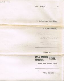
Document - MCCOLL, RANKIN AND STANISTREET COLLECTION: MINING LEASE NO 10173 GARDEN GULLY SHAFT, 9th March, 1934
Mining lease 5 page document for lease application 10173, dated 9th March 1934, within area bounded by Don, Barnard Streets up to Mt. Korong Road, area 10 acres. Document signed by John Jepson Stanistreet in the presence of W.A. Kell, Warden's Clerk, Bendigo. Hand coloured plan of lease appended to document, yellow section refers to lease. Marked on map Central Garden Gully shaft. On front of lease ' entered in the Register Book Vol 303 Fol 33698' On back ' His Majesty the King to J.P. Stanistreet (Cent G Gully not renewed written in pencil) Form C Gold Mining Lease Crown and Private Land'gold, mining, garden gully shaft -
 Bendigo Historical Society Inc.
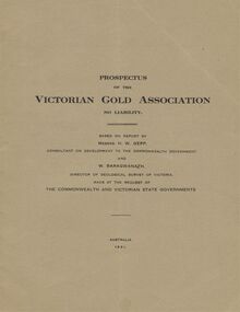
Document - MCCOLL, RANKIN AND STANISTREET COLLECTION: VICTORIAN GOLD ASSOCIATION, 1931
Prospectus of the Victorian Gold Association N.L. Based on a report by Messrs H. W. Gepp Consultant on Development to the Commonwealth Government and W. Baragwanath, Director of the Geological Survey of Victoria. Dated 1931 This company was formed to investigate the Deborah Mine, The Central Nell Gwynne Mine and the Monument Hill Mine. 12 pages including maps and Transverse Sections of the MinesThe Commonwealth and Victorian State Governments. E. Whitehead & Co., Pty., Ltd Printers 21 Equitale Place, Melbourne, C1.gold, mining, prospectus, bendigo, gold mines, victorian gold associatian, deborah mine, central nell gwynne mine, monument hill mine. -
 Bendigo Historical Society Inc.
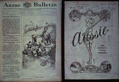
Slide - DIGGERS & MINING: THE DIGGERS, c1918
Diggers & Mining: The Diggers. Slide of ANZAC BULLETIN, London August 7, 1916 (on left of slide). Ride side of slide is the back cover of a Bulletin dated April 4, 1918 with artwork on it, main section has a soldier with the word Aussie across it, the head of the soldier is the map of Australia the wording 'The Australian Soldiers' Magazine' along side the soldier. Markings by hand: This may ease a smile be\fore the bell goes at quarter to one SCR. Dated April 4, 1918. Markings: VISAR COPYRIGHT SET - THE DIGGERS, 13. Used as a teaching aid.Visaireducation, tertiary, war -
 Bendigo Historical Society Inc.
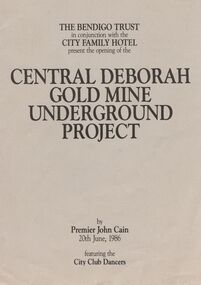
Book - JOAN O'SHEA COLLECTION: CENTRAL DEBORAH UNDERGOUND PROJECT, 20th June, 1986
Joan O'Shea Collection. Central Deborah Gold Mine Bendigo Violet Street (off High Street) Bendigo Pamphlet. Buff and Sepia double-sided A4. The Bendigo Trust in conjunction with the City Family Hotel present the opening of the Central Deborah Gold Mine Underground Project, by Premier John Cain, 20th June, 1986 featuring the City Club Dancers. Includes a brief chronological history of the mine and photographs courtesy of Phillip Beer on recto side. The verso side contains a map of the site of the Central Deborah Gold Mine and also various photographs with further detail of areas of interest including: poppet legs and shaft, the change rooms, caretakers or rag pickers room where clothing was searched, the drying room, the first aid room, carbide light room, underground tours, carpenters shed, ore bins and loading bays, stamper battery, wilfley table, berdan plans, laboratory, display room, boiler, stoke hold, winding engine, boiler feed pump, electric driven compressor, steam driven compressor and the blacksmith's shop.Central Deborah Gold Mine Bendigobendigo, gold mining, central deborah gold mine -
 Bendigo Historical Society Inc.
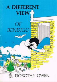
Book - JOAN O'SHEA COLLECTION: A DIFFERENT VIEW OF BENDIGO POEMS, 1985
Joan O'Shea Collection. A Different View of Bendigo. Dorothy Owen. Illustrated Book of Poetry 60 Pages. Written by Local Author. Contains a map of the region of Bendigo and Surrounds along with 39 poems about Bendigo's History covering topics as diverse as How Bendigo received its name, renowned Bendigo icons such as Alexandra Fountain, The Shamrock Hotel, Hargreaves Mall, The Law Courts, Charing Cross and the Bendigo Base Hospital to Bendigo's Chinese Heritage, Gold Detecting, Highland Bands, The Dragon and Bendigo's People.Dorothy Owen Published by Bendigo Modern Press 1985bendigo, history, city history local poetry -
 Bendigo Historical Society Inc.
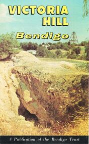
Document - JOAN O'SHEA COLLECTION: VICTORIA HILL GOLDMINING AREA BOOKLET, March 1972
Joan O'Shea Collection. Victoria Hill Bendigo Gold Mining on the Richest Quartz Reef in Bendigo, from 1854 to 1916. Colour and Black and White Booklet 16 Pages. Includes Maps of the Victoria Hill Area, photographs of the remains of a twenty head crushing battery, burnt ground from quartz roasting, The Victoria Quartz Mine Photograph from Australian Mining Standard June 1899, The compressor beds and concrete foundations for the poppet legs all that remain today of the Victoria Quartz Mine deepest mine on Bendigo Goldfield 4613 feet or 1406.04 metres. Also included photograph of the view of Victoria Hill from The New Chum Hill in the 1870s. The Location of the 3 mines Ballerstedt's open cut, North Old Chum and Lansell's 180 are marked. A depiction of Rae's Open Cut gives an understanding of the primitive nature of early workings on the Goldfields. The Booklet also provides a brief history of Victoria Hill itself.Bendigo Trust Publication March 1972. Printed in Bendigo Cambridge Press.bendigo, mining, victoria hill -
 Bendigo Historical Society Inc.
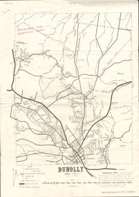
Document - JOAN O'SHEA COLLECTION: DUNNOLLY MAPS, 1980
Joan O'Shea Collection. Goldfield Maps Dunolly 3 Sheets 1980. Page 1: Mines in Dunolly, Whistling Flat, Painswick and Surrounds. Page 2: Mines in Goldsborough, McKinnons Gap, Bealiba Range, Stewarts Flat and Surrounds. Page 3: Mines in Dunolly, Emu Creek, Bet Bet, Bromley & Surrounds. Scale in Chains and Kilometres.GoldField Maps 1980 based on Dunolly 7624 by Division of National Mappinggold, goldfields, goldfield maps dunolly & surrounds -
 Bendigo Historical Society Inc.
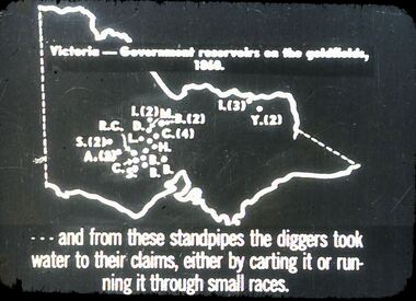
Slide - DIGGERS & MINING. GETTING THE GOLD, c1860
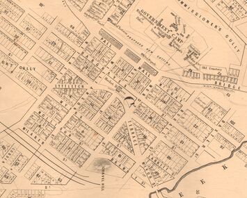
Diggers & Mining. Getting the Gold. Slide: Map of Victoria. Victoria - Government reservoirs on the goldfields, 1860. Letters on map relate to the position of the reservoirs standpipes. And from these standpipes the diggers took water to their claims, either by carting it or running it through small races. Markings: 72 994.LIF:4. Used as a teaching aid.hanimounteducation, tertiary, goldfields -
 Bendigo Historical Society Inc.
Slide - DIGGERS & MINING. GETTING THE GOLD, c1860
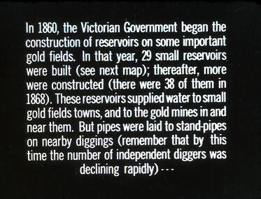
Diggers & Mining. Getting the Gold. Slide: In 1860, the Victorian Government began the construction of Reservoirs on some important gold fields. In that year, 29 small reservoirs were built (see next map); thereafter, more were constructed (there were 38 of them in 1868). These reservoirs supplied water to small gold fields towns, and to the gold mines in and near them. But pipes were laid to stand-pipes on nearby diggings (remember that by this time the number of independent diggers was declining rapidly) Markings: 71 994.LIF:4. Used as a teaching aid.hanimounteducation, tertiary, goldfields -
 Bendigo Historical Society Inc.
Document - MARKS COLLECTION: NEW CHUM LINE OF REEF MAP
Plan (copy) of New Chum Line of Reef . Plan has been copied in two sections. On top of plan 'Underground survey of mines Sandhurst, New Chum Line of Reef' , plan shows longitudinal and cross section views of the workings on the reef. Shaft No. 76 marked. Datum line on top indicates 750' above sea level, on bottom of plan, bottom of shaft 2022.24 below sill. Drawn by Arthur Everett, Mining Department, Melbourne, 1884.bendigo, mining, new chum line of reef -
Bendigo Historical Society Inc.
Map - BENDIGO, GREATER CITY OF, 2013
... Map, City of Greater Bendigo, Epsom/Huntly, Heathcote... BENDIGO Hospital Map, City of Greater Bendigo, Epsom/Huntly ...Map, City of Greater Bendigo, Epsom/Huntly, Heathcote, Strathfieldsaye/ Junortoun, Mandurang, Sebastian, Mia Mia, Maiden Gully, Ravenswoon, Axedale, Myers Flat, Redesdale, September 2013, on front. Lockwood South, Marong, Raywood, Neilborough, Elmore, Goornong, on reverse side. ( number 413 in Map Cupboard 1 ). Donated by Bendigo Council.bendigo, hospital -
Bendigo Historical Society Inc.
Map - MARKS COLLECTION: MAP OF WALES 1880
... Inc. History House 11 Mackenzie Street Bendigo goldfields MAP ...Original map - Wales, U.K. On bottom of map 'electroplated in 1880'. Scale of 1 inch to a statute mile'. Written on back in black pen 'Map'. Map found in wardrobe sold at Lansell's Fortuna auction in 1930's.map -
Bendigo Historical Society Inc.
Map - PANNOOMILLOO : COUNTY OF BENDIGO, 1957
... Map. Pannoomilloo, County of Bendigo, Pannoobamawm, Milloo... BENDIGO Hospital W.M. Houston, Government Printer, Melbourne. Map ...Map. Pannoomilloo, County of Bendigo, Pannoobamawm, Milloo, Warragamba, Diggorra, Property Allotments. Drawn and Reproduced at the Department of Lands and Survey,1957. Price 2/-. (number 412 in Map Cupboard 1 ).W.M. Houston, Government Printer, Melbourne.bendigo, hospital -
Bendigo Historical Society Inc.
Map - WANURP: COUNTY OF BENDIGO, 1/12/33
... Map. Wanurp, County of Bendigo, Terrick Terrick East... BENDIGO Hospital H.J. Green, Government Printer Map. Wanurp ...Map. Wanurp, County of Bendigo, Terrick Terrick East, Mitiamo, Dingee, Milloo, Pannoobamawm. L422+. Photo-Lithographed at the Department of Lands and Survey, Melbourne, Price 2/-. 1/12/33 ( number 411 in Map Cupboard 1 )H.J. Green, Government Printerbendigo, hospital -
Bendigo Historical Society Inc.
Map - PANNOOBAMAWM : COUNTY OF BENDIGO, 1957
... Map. Pannoobamawm, County of Bendigo, Terrick Terrick East... BENDIGO Hospital W.M. Houston, Government Printer, Melbourne. Map ...Map. Pannoobamawm, County of Bendigo, Terrick Terrick East, Wanurp, Pannoomilloo, Bamawm, Turrumberry, property allotments. Drawn and reproduced at the Department of Lands and Survey, 1957, Price 2/-. (number 410 in Map Cupboard 1 ).W.M. Houston, Government Printer, Melbourne.bendigo, hospital -
Bendigo Historical Society Inc.
Map - NERRING : COUNTY OF BENDIGO, August 1952
... Map. Nerring, County of Bendigo, Leichardt, Marong... BENDIGO Hospital J.J. Gourley, Government Printer, Melbourne. Map ...Map. Nerring, County of Bendigo, Leichardt, Marong, Sandhurst, Huntly, Neilborough, Yarraberb. Drawn and Reproduced at the Department of Lands and Survey, Melbourne, Victoria, August 1952, Price 2/-.( number 409 in Map Cupboard 1).J.J. Gourley, Government Printer, Melbourne.bendigo, hospital -
Bendigo Historical Society Inc.
Map - MARKS COLLECTION: TRAMWAY OR RAILWAY MAP SANDHURST
... Bendigo Historical Society Inc. Bendigo Historical Society ...Original map of 'land granted as endowment' for tramway or railway. On top Rh corner of map, in bold print 'Sandhurst, Inglewood & Loddon district Tramway or Railway.Land granted as endowment shaded, scale 60 chains to 1 inch. Lithographed by J & W. Holmes, Lith. Sandhurst'. Signed by Geo Avery Fletcher, Engineer. Map shows Parish of Leichardt, Parish of Yarraberb, Parish of Bridgwater and a section of Marong. On bottom RH corner, is small map of Sandhurst, showing railway reserve. Top LH corner, Inglewood. Map shows route of railway line from Sandhurst to Inglewood. -
Bendigo Historical Society Inc.
Map - MARKS COLLECTION: CLAIM MAP SANDHURST
... Inc. History House 11 Mackenzie Street Bendigo goldfields MAP ...Original hand drawn map showing lease holders along Mt. Korong Road, Sandhurst area. Names include Gold Mines Co., Hercules Co., H. Koch, Prince Alfred Co, Advance Co., J. Steane, Skeals, Abel & Co., Mounts(?) Bay co., Wellington Co., Waterloo Co., Endeavour Co., W.H. Langdon, Bridgman & Co. Written in blue pencil on top RH corner in script Syme Well, Nova Ste (indecipherable) , German Aleno Co., Concord, Rae. Written on back of map in black pen 'Maps'.map, bendigo, mining leases -
 Bendigo Historical Society Inc.
Map - MARKS COLLECTION: MAP SANDHURST 1867
... Inc. History House 11 Mackenzie Street Bendigo goldfields MAP ...Original map: Sandhurst 1867, shows central Bendigo and surrounds, including police camp, stockade, 'old cemetery', reserve for. On bottom of map: 'Lithographed at the Department of Lands and Survey by D. Henderson, 20 February, 1867'. On top RH corner 'Sheet No 1 Sandhurst'.map, bendigo, 1867 sandhurst map -
 Bendigo Historical Society Inc.
Magazine - PETER ELLIS COLLECTION: MALDON FOLK FESTIVAL
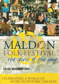
Eight copies of Maldon Folk Festival books for the years 2002, containing a programme alterations loose page; 2003; 2004; 2005; 2006, containing a 2006 Maldon Folk Festival Performers application; 2007; 2008 containing a Maldon Folk Festival Survey form; and 2010, containing a Maldon Folk Festival Survey form. All have colourful front covers with the name and dates printed on them. Also contains features, names of performers, advertisements, programmes and a map of the area. Performers include Emu Creek Bush Band, Wedderburn Old Timers and Peter Ellis.magazine, organization, maldon folk festival, peter ellis collection, emu creek bush band, wedderburn old timers, peter ellis -
 Bendigo Historical Society Inc.
Slide - DIGGERS & MINING. THE GOLD LICENCE, c1854
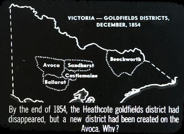
Diggers & Mining. The gold licence. The Government Camp. Slide depicts map of Victoria with the 5 gold rush regions marked on it. Beechworth, Sandhurst Avoca, Castlemaine and Ballarat. By the end of 1854, the Heathcote goldfields district had disappeared, but a district had been created on the Avoca. Why? Markings: 31 994.LIF. 4. Used as a teaching aid.hanimounteducation, tertiary, goldfields -
 Bendigo Historical Society Inc.
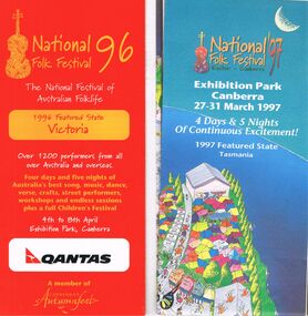
Document - PETER ELLIS COLLECTION: NATIONAL FOLK FESTIVAL, 3rd February, 1996
Collection of National Folk Festival programs and literature. Programs from the years 1995, 1996 and 1998. All have colourful covers and contains General Information, information on performers, programs, site maps, some photos of performers and some health information. Some pamphlets include a Ticket Order Form and a larger National Folk Festival 97 where the featured state is Tasmania. Letter to John Williams from Phil Wilson, Director National Folk Festival, dated 3 February 1996 confirming performance and ticket details for Emu Creek Bush Band CD Launch.entertainment, music, national folk festival, peter ellis collection, emu creek bush band, peter ellis -
 Bendigo Historical Society Inc.
Document - PETER ELLIS COLLECTION: NATIONAL FOLK FESTIVAL, 16th - 20th April, 1992
Literature from the 26th National Folk Festival held in Canberra on the 16-20 April 1992. Program containing General Information, the Performers (including the Emu Creek Bush Band), Festival Map, the Programme and Dance Programme Information. Also leaflets: Visitors Guide, Program, Embassies in Canberra, University Halls of Residence Bruce Burton & Garran Halls Information for Visitors, Map of Australian National University, and an article titled 'Real Folk' with information about performers. Pioneer Performers Series Information Sheet April 1992 contains Introduction, Current Available Items, Current Projects, Forthcoming Events and Ramblings of a Modern Day Collector.entertainment, music, national folk festival, peter ellis collection, australian national university, 26th national folk festival canberra 1992, the monaro folk music society, emu creek bush band, wongawilli colonial dance club inc -
 Bendigo Historical Society Inc.
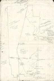
Map - PETER ELLIS COLLECTION: MAP AREA AROUND MITIAMO
... Inc. History House 11 Mackenzie Street Bendigo goldfields MAP ...Copy of a hand drawn map of an area near Mitiamo with various plants/trees, features and Aboriginal Water Holes drawn in. Also a smaller copy of the top part and two smaller copies of the lower half of the map.map, victoria, rushworth/whroo, peter ellis collection, mitiamo area, aborigine water holes -
 Bendigo Historical Society Inc.
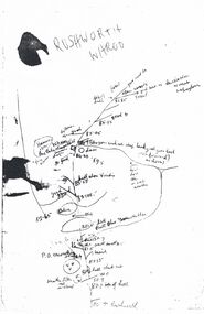
Map - PETER ELLIS COLLECTION: MAP
... Inc. History House 11 Mackenzie Street Bendigo goldfields MAP ...Five photocopies of drawings of the Rushworth area and three copies of Rushworth-Whroo. All maps have various features and some plants noted. Also mentioned is the Balaclava Hill Open Cut Mine.map, victoria, rushworth/whroo, peter ellis collection, rushworth, whroo, aboriginal water holes, balaclava hill open cut mine