Showing 26086 items
matching councilors
-
 Greensborough Historical Society
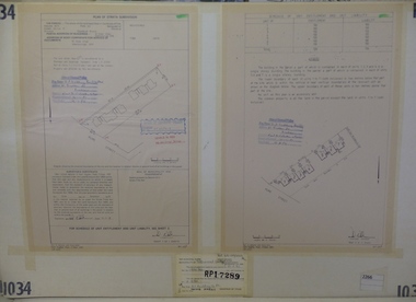
Planning Document, Subdivision Plan #1034. 50 Hume Street, 03/02/1982
Plan of Strata Subdivision at 50 Hume Street Greensborough for 7 units.An example of hard copy subdivision plans from the Greensborough area. Mainly from the Shire of Diamond Valley era (1964-1994).Plan (2 sheets) mounted on heavy card.Stamped and handwritten Council permissions, dates and other details.subdivision plan -
 Greensborough Historical Society
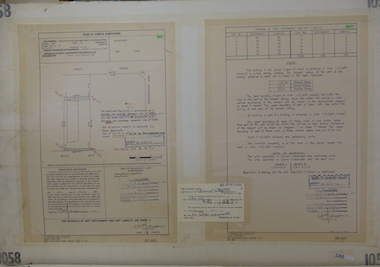
Planning Document, Subdivision Plan #1058. Wattle Drive Watsonia, 14/07/1983
Plan of Strata Subdivision at 6 Wattle Drive Watsonia for 6 units.An example of hard copy subdivision plans from the Greensborough area. Mainly from the Shire of Diamond Valley era (1964-1994).Plan (3 sheets) mounted on heavy card.Stamped and handwritten Council permissions, dates and other details.subdivision plans, wattle drive watsonia -
 Greensborough Historical Society
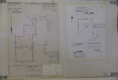
Planning Document, Subdivision Plan #1041. Elder Street Greensborough, 20/04/1983
Plan of Consolidation of Allotments 3 and 4 Brixton Avenue and Plan of Subdivision for Elder Street. An example of hard copy subdivision plans from the Greensborough area. Mainly from the Shire of Diamond Valley era (1964-1994).Plan (2 sheets) mounted on heavy card.Stamped and handwritten Council permissions, dates and other details.subdivision plans, elder street, brixton avenue -
 Greensborough Historical Society
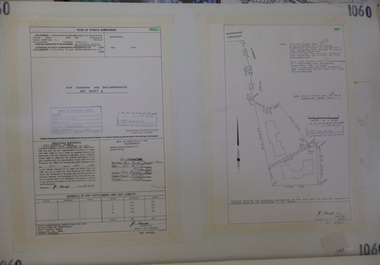
Planning Document, Subdivision Plan # 1060, 8 Ulmara Place Greensborough, 20/04/1983
Plan of Strata Subdivision at 8 Ulmara Place Greensborough for 2 houses.An example of hard copy subdivision plans from the Greensborough area. Mainly from the Shire of Diamond Valley era (1964-1994).Plan (3 sheets) mounted on heavy card.Stamped and handwritten Council permissions, dates and other details.subdivision plans, ulmara place -
 Greensborough Historical Society
Planning Document, Subdivision Plan # 1016. Corner Weidlich and St Clems Roads Greensborough, 05/10/1981
Plan of Subdivision of land at corner of Weidlich Road and St Clems Road Greensborough.Plan (2 sheets) mounted on heavy card.Stamped and handwritten Council permissions, dates and other details.subdivision plans, weidlich road -
 Greensborough Historical Society
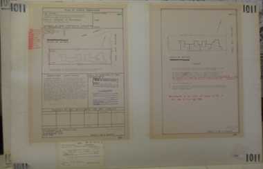
Planning document, Subdivision Plan #1011. Corner Mountainview Road and Hume Streets, 1981_
Plan of Strata Subdivision for units at corner of Mountainview Road and Hume Street Briar Hill.An example of hard copy subdivision plans from the Greensborough area. Mainly from the Shire of Diamond Valley era (1964-1994).Plan (2 sheets) mounted on heavy card.Stamped and handwritten Council permissions, dates and other details.subdivision plans, mountainview road, hume street -
 Greensborough Historical Society
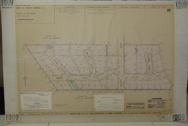
Planning document, Subdivision Plan #1009. Corner Allumba Drive and Beales Road Greensborough, 1981_
Plan of Subdivision of land at corner of Allumba Drive and Beales Road Greensborough.An example of hard copy subdivision plans from the Greensborough area. Mainly from the Shire of Diamond Valley era (1964-1994).Plan (2 sheets) mounted on heavy card.Stamped and handwritten Council permissions, dates and other details.subdivision plans, allumba drive, beales road -
 Greensborough Historical Society
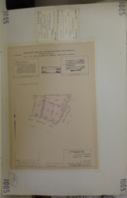
Planning document, Subdivision Plan #1005. Corner Douglas Court and Glen Katherine Drive Greensborough, 1981_
Plan of Subdivision. Corner Douglas Court and Glen Katherine Drive Greensborough.An example of hard copy subdivision plans from the Greensborough area. Mainly from the Shire of Diamond Valley era (1964-1994).Plan (2 sheets) mounted on heavy card.Stamped and handwritten Council permissions, dates and other details.subdivision plans, douglas court, glen katherine drive -
 Greensborough Historical Society
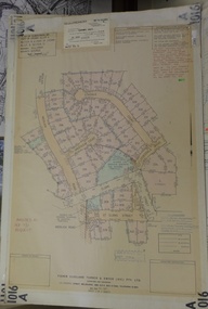
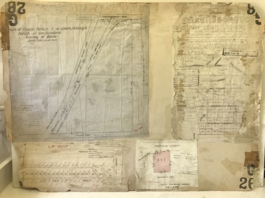
Planning document, City of Heidelberg, Subdivision Plan # G26. Grace Park Estate Greensborough, 1950c
Plan of Subdivision (G26). Grace Park Estate. An example of hard copy subdivision plans from the Greensborough area. From Shire of Heidelberg.Plan mounted on heavy card.Stamped and handwritten Council permissions, dates and other details.subdivision plans, grace park -
 Greensborough Historical Society
Planning Document, John Taylor & Assoc, Subdivision Plan # 541, Somerleigh Crescent and Rainham Close, Greenhills, 21/06/1971
Plan of Subdivision at Somerleigh Crescent and Rainham Close, Greenhills.An example of hard copy subdivision plans from the Greensborough area. Mainly from the Shire of Diamond Valley era (1964-1994).Plan (2 sheets) mounted on heavy card.Stamped and handwritten Council permissions, dates and other details.subdivision plans, somerleigh crescent greensborough, rainham close greensborough -
 Glenelg Shire Council Cultural Collection
Functional object - Pen - Glenelg Shire Council, n.d
Pen, boxed, biro, maroon with gold trims, gold lettering and gold Glenelg Shire logo on cap.Front: 'Glenelg Shire Council Victoria, Australia' - goldglenelg shire council souvenir, pen -
 Ringwood and District Historical Society
Book - One Dragon's Dream, Peter Pavey
This book by Peter Pavey won the Australian Children's Picture Book of the Year in 1980. It was published as a Walker classic. Peter Pavey was a resident of Ringwood and now has retired to a walnut farm.Book by local Ringwood author. Brightly coloured covers with title on front and text on mustard coloured back page. 20 pages of multicoloured drawings and text with ten pages dedicated to counting animals.The Children's Book Council Of Australia - Picture Book Of The Year. -
 Bendigo Historical Society Inc.
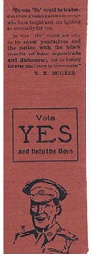
Document - GILBERT RULE COLLECTION: NATIONAL REFERENDUM COUNCIL ADVERTISEMENT, 1914-18
Document - fold over top. Outside "If you turn down the boys at the front you leave them to die" printed in black ink. Picture of soldier at bottom. Inside "Vote yes and help the boys". Writing inside is attributed to W.M. Hughes.National Referendum Council, 595 Collins St., Melbourneperson, individual, gilbert rule -
Port Melbourne Historical & Preservation Society
Letter - History of Swallow & Ariell, 19 Nov 2004
Letter regarding history of Swallow & Ariell's fire bell.signed 'Pat xx'; also, 'Sth Melb Council'fire and fire services, swallow & ariell ltd, norm robinson, norma robinson -
 Stanley Athenaeum & Public Room
Furniture - Lectern - wooden, Lectern
Wooden stand - lightweight, sealed surface. Four pronged legs at the base. sturdy construction. Strong main support. Stand sloped higher at back of board.formerly 'Beechworth Art Council' written on back of board -
 Hume City Civic Collection
Photograph
A black and white image of twelve turkeys in a farm yard. In the background on the LH side there is a tree and a picket fence next to the farm gate and shed with a wire fence and tree.on back: Melton Shire Council Meeting / Diggers Restcullinan, uraina, eileen, chris, farming, turkeys, farms, bayview farm, george evans collection -
Stawell Historical Society Inc
Plan, A Master Plan for Central Park Stawell, 2000
Grey Cover. Fawn binder a4 SizeMay 2000 Prepared for the Northern Grampians Shire Councilsport, central park, northern grampians shire -
 Greensborough Historical Society
Poster - Planning Document, City of Heidelberg, Subdivision Plan # G313, Corner Main and Grimshaw Streets, Greensborough, 08/03/1960
Plan of Subdivision at corner of Main and Grimshaw Streets, Greensborough.An example of hard copy subdivision plans from the Greensborough area. Mainly from the Shire of Diamond Valley era (1964-1994).Plan (2 sheets) mounted on heavy card.Stamped and handwritten Council permissions, dates and other details.subdivision plans, main street greensborough, grimshaw street greensborough -
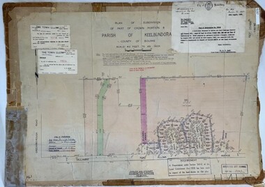
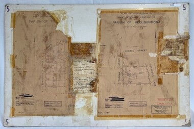
 Greensborough Historical Society
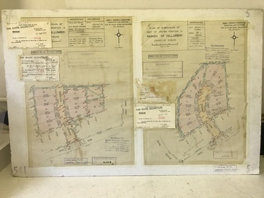
Poster - Planning Document, City of Heidelberg, Subdivision Plan # G 27, Greensborough and Diamond Creek, 1922 and 1963
Plan of Subdivisions in City of Heidelberg: Side 1: 2 plans, Parish of Keelbundoora: plan 1: Henry Street, Vermont Avenue, Lyell Street, Nell Street, McDowell Street, 1922. Plan 2: Henry Street, Nepean Street, Charles Street, 1922. Side 2: 2 plans Parish of Nillumbik, Portion 13: Plan 1: Diamond Creek Road, Delfin Crescent, Ridge Road, 1963. Plan 2: Kinglake Road, Eltham Road, 1963.An example of hard copy subdivision plans from the Greensborough area. Mainly from the Shire of Diamond Valley era (1964-1994).Plan (2 sided) mounted on heavy card. Contains 2 sheets pasted together.Stamped and handwritten Council permissions, dates and other details.subdivision plans, city of heidelberg -
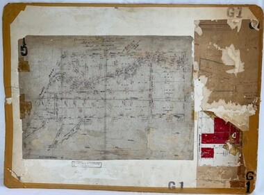 Greensborough Historical Society
Poster - Planning Document, Shire of Diamond Valley, Subdivision Plan # G 1, Watsonia, 1962 and 1976
Plan of Subdivisions in Shire of Diamond Valley: Side 1: subdivision of LP5406 bounded by Plenty Road, Greensborough Road, Meakin Avenue, Watsonia and includes Aqueduct Road, 1976. Side 2: 2 plans - Keelbundoora: Morwell Avenue and Grace Street; Nillumbik: Inglis Street and Chute Street Diamond Creek, 1962An example of hard copy subdivision plans from the Greensborough area. Mainly from the Shire of Diamond Valley era (1964-1994).Plan (2 sided) mounted on heavy card. Contains 2 sheets pasted together.Stamped and handwritten Council permissions, dates and other details. subdivision plans, diamond creek, shire of diamond valley -
 Greensborough Historical Society
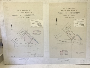
Poster - Planning Document, City of Heidelberg et al, Subdivision Plan # H 41 - Crown portion 8, Parish of Keelbundoora - Yallambie, and Crown Portion 9, Parish of Keelbundoora, 1922-1967
Planning Document: Subdivision Plan # H 41 Side 1, Crown portion 8, Parish of Keelbundoora - Yallambie Road, Allima Avenue, Koolya Court, Ekam Court (Jennings Estate). Side 2: Crown Portion 9, Parish of Keelbundoora consist of 5 small subdivision sheets: 1. Somers Avenue, Stewart Terrace, Toubay Street and Railway Place (no date); 2. Somers Avenue, Maxwell Street, Greensborough Road, 1924; 3. Heidelberg Avenue, Golf Avenue, St Andrews Avenue (no date); 4. Birdwood Avenue, May Street (no date); 5. Strathallan Road 1924.An example of hard copy subdivision plans from the Greensborough area. Mainly from the Shire of Diamond Valley era (1964-1994).Plan (2 sided) mounted on heavy card. Stamped and handwritten Council permissions, dates and other details.subdivision plans, city of heidelberg, yallambie, macleod, greensborough -
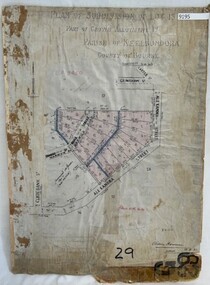 Greensborough Historical Society
Poster - Planning Document, City of Heidelberg, Subdivision Plan # G 29 Part 1, Crown allotment 17, Greensborough, 1922
Plan of Subdivisions in City of Heidelberg: Parish of Keelbundoora: Crown allotment 17 - Warwick Road, Clydbank Street, Alexandra Street, 1922.An example of hard copy subdivision plans from the Greensborough area. Mainly from the Shire of Diamond Valley era (1964-1994).Plan (single sided) mounted on heavy card. Stamped and handwritten Council permissions, dates and other details.subdivision plans, city of heidelberg -
 Greensborough Historical Society
Poster - Planning Document, City of Heidelberg, Subdivision Plan # G 29 Part 2, Crown portion 16, Greensborough, 1951
Plan of Subdivisions in City of Heidelberg: Parish of Keelbundoora: Crown portion 16 - Daours Court and Devonshire Road, 1951.An example of hard copy subdivision plans from the Greensborough area. Mainly from the Shire of Diamond Valley era (1964-1994).Plan (single sided) mounted on heavy card. Stamped and handwritten Council permissions, dates and other details.subdivision plans, city of heidelberg -
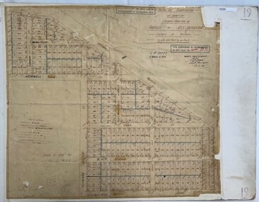
 Greensborough Historical Society
Poster - Planning Document, City of Heidelberg et al, Subdivision Plan # 5 - Crown Portion 17, Parish of Nillumbik, and Crown Portion18, Parish of Keelbundoora, 1925-1972
Subdivision Plan # 5 - Side 1: Crown portion [unknown - damaged], Parish of Nillumbik, Springfield Street, Turner Street Briar Hill,1963 amended 1972 and Crown Portion17, Parish of Keelbundoora: Thoona Grove, Donald Street. Paterson Crescent Greensborough, 1963 amended 1967. Side 2: Parish of Keelbundoora, Crown Portion 18: Boyd Street, Kempston Street Greensborough 1925; and Main Street Greensborough. An example of hard copy subdivision plans from the Greensborough area. Mainly from the Shire of Diamond Valley era (1964-1994).Plan (2 sided) mounted on heavy card. Stamped and handwritten Council permissions, dates and other details.subdivision plans, city of heidelberg, greensborough, briar hill, main street greensborough -
Clunes Museum
Document - REPORT, HEPBURN SHIRE, 2024
PLANNING POLICY PRINCIPLES WILL BE TAILORED TO RESPOND TO LANDSCAPE VARIATION AND DRIVERS OF LAND USE CHANGE AND THE DIFFERENTIAL IMPACT THAT THESE HAVE ACROSS THE SHIRE....1 RURAL HEPBURN - AGRICULTURAL LAND STUDY AND RURAL SETTLEMENT STRATEGY, UNBOUND REPORT PRINTED IN COLOUR ON PAPER, 94 PAGES .2 FUTURE HEPBURN - CLUNES STRUCTURE PLAN, UNBOUND REPORT PRINTED IN COLOUR ON PAPER, 67 PAGES ADOPTED BY HEPBURN SHIRE COUNCIL 3 SEPTEMBER 2024hepburn shire council, rural settlement strategy -
 Greensborough Historical Society
Poster - Planning Document, Shire of Diamond Valley et al, Subdivision Plan # 1018 - Parish of Nillumbik, County Bourke, Crown Allotment 4 Section 15, and Crown Allotment B Section 12, Eltham North, 1981-1982
Subdivision Plan # 1018 - Parish of Nillumbik, County Bourke, Crown Allotment 4 Section 15, and Crown Allotment B Section 12, Eltham North. This subdivision plan includes Ryans Road (also known as Government Road) and St Clems Street. The developer for this subdivision is Taunton Developments and the Surveyors are Fisher Cleeland Turner & Dwyer Vic, Surveyors and Engineers.An example of hard copy subdivision plans from the Greensborough area. Mainly from the Shire of Diamond Valley era (1964-1994).Plan (single sided) mounted on heavy card. Stamped and handwritten Council permissions, dates and other details. subdivision plans, shire of diamond valley, taunton developments -
 Greensborough Historical Society
Poster - Planning Document, Shire of Diamond Valley et al, Subdivision Plan # 1026 - Parish of Nillumbik, County Bourke, Crown Allotment B Section 12, Eltham North, 1981-1984
Subdivision Plan # 1026 - Parish of Nillumbik, County Bourke, Crown Allotment B Section 12, Eltham North. This subdivision plan includes Ryans Road (also known as Government Road) and St Clems Street. The developer for this subdivision is Taunton Developments and the Surveyors are Fisher Cleeland Turner & Dwyer Vic, Surveyors and Engineers.An example of hard copy subdivision plans from the Greensborough area. Mainly from the Shire of Diamond Valley era (1964-1994).Plan (single sided) mounted on heavy card. Stamped and handwritten Council permissions, dates and other details. subdivision plans, shire of diamond valley, taunton developments -
 Greensborough Historical Society
Poster - Planning Document, Shire of Diamond Valley et al, Subdivision Plan # 1044 - Parish of Nillumbik, County Bourke, Crown Allotment B Section 12, Eltham North, 1981-1987
Subdivision Plan # 1044 - Parish of Nillumbik, County Bourke, Crown Allotment B Section 12, Eltham North. This subdivision plan includes Weidlich Road and St Clems Street. The developer for this subdivision is Taunton Developments and the Surveyors are Fisher Cleeland Turner & Dwyer Vic, Surveyors and Engineers.An example of hard copy subdivision plans from the Greensborough area. Mainly from the Shire of Diamond Valley era (1964-1994).Plan (single sided) mounted on heavy card. Stamped and handwritten Council permissions, dates and other details. subdivision plans, shire of diamond valley, taunton developments -
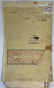
 Greensborough Historical Society
Poster - Planning Document, City of Heidelberg, Subdivision Plan # 19 - Parish of Keelbundoora, Crown Portion 16, Watsonia "Black's subdivision', 1924
Subdivision Plan # 19 - Parish of Keelbundoora, Crown Portion 16, Watsonia "Black's subdivision". This subdivision plan includes proposed street names which were later changed (e.g. Morwell Street (not Morwell Avenue) now called Greenwood Drive). Includes Lambourn Road, Black Street, Grace Street, Eden Avenue, High Street, Kenmare Street, Morwell Avenue, Greensborough Road, Mundy Street, Ladd Street.An example of hard copy subdivision plans from the Greensborough area. Mainly from the Shire of Diamond Valley era (1964-1994).Plan (single sided) mounted on heavy card. Stamped and handwritten Council permissions, dates and other details. subdivision plans, city of heidelberg, greensborough, main street greensborough, shire of heidelberg, watsonia, black family -
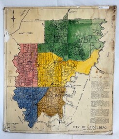 Greensborough Historical Society
Poster - Map, City of Heidelberg, 1965c
Map of the City of Heidelberg showing municipal boundaries and Wards are coloured. Scale 20 chains to 1 inch.An example of hard copy plans from the 1960s. Mainly from the Shire of Diamond Valley era (1964-1994).Colour map, pasted on card and laminated.Stamped and handwritten Council permissions, dates and other details. city of heidelberg, heidelberg - maps, local government