Showing 10092 items matching "demolished"
-
 Eltham District Historical Society Inc
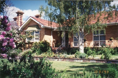
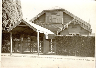
Photograph, Margaret Ball, 77 Dalton Street, Eltham, c.2004, 1999
Owner 1930s: Mrs M. Davis. Bought by Joe Mason in 1940s; demolished 2002 and five units built 2004The Margaret Ball (Pre 1960s Houses) Collection was a personal project initiated to mark the year 2000 and arose as a result of the disappearance of many pre-1960s parts of Eltham due to development. Approximately 200 pre-1960s style houses that were left in Eltham between Main Road and east to Bible Street, between Cecil Street to the north and south to Dalton Street were photographed in late 1999. Not all of the houses could be photographed; some because the garden or trees blocked the view of the house, others because of rubbish or cars were in the way, some because people were working on the house or in the gardens at the time.Colour photographic printeltham, houses, streets, margaret ball (pre 1960s houses) collection, dalton street -
 Eltham District Historical Society Inc
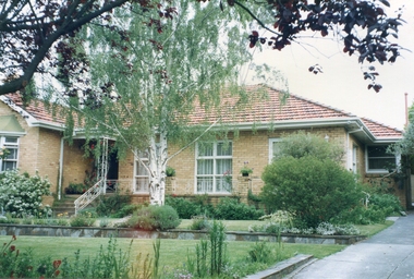
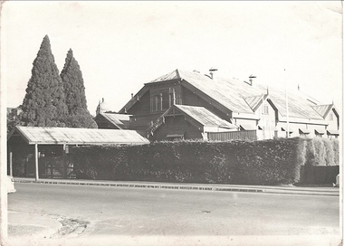
Photograph, Margaret Ball, 77 Dalton Street, Eltham, c.2002, 1999
Owner 1930s: Mrs M. Davis. Bought by Joe Mason in 1940s; demolished 2002 and five units built 2004The Margaret Ball (Pre 1960s Houses) Collection was a personal project initiated to mark the year 2000 and arose as a result of the disappearance of many pre-1960s parts of Eltham due to development. Approximately 200 pre-1960s style houses that were left in Eltham between Main Road and east to Bible Street, between Cecil Street to the north and south to Dalton Street were photographed in late 1999. Not all of the houses could be photographed; some because the garden or trees blocked the view of the house, others because of rubbish or cars were in the way, some because people were working on the house or in the gardens at the time.Colour photographic printeltham, houses, streets, margaret ball (pre 1960s houses) collection, dalton street -
 Stawell Historical Society Inc
Photograph, Wehl Family home "Carlsruhe" on the Western Highway
Front Corner of Living Room and bay Windows Private Home "Carlsruhe" Western Highway (Wehl) Family Demolished 1993stawell -
 University of Melbourne, Burnley Campus Archives
Photograph - Black and white print, Principal's Residence, 1947
Appears as an illustration in, "Green Grows Our Garden," A.P. Winzenried p 128.The focal point of the Gardens, was demolished in 1980.Black and white photograph. Principal's Residence from south-east angle. Similar to B91.8On reverse, "20/10/47 Verichrome Yellow View of house from south-east."principal's residence, green grows our garden, a.p. winzenried -
 Ballarat Heritage Services
Photograph - Photograph - Colour, Chellowdene, 37 Wills St, Kew, 1993, 03/10/1993
Chellowdene was demolished c1996, and four units were built on the block. It has two owners. The Wood Family and the Gervasoni Family.A cream brick house in Wills Street, Kew. It was known as Chellowdene. chellowdene, 37 wills st kew, architecture -
 Ballarat Heritage Services
Photograph - Photograph - Colour, Chellowdene, 37 Wills St, Kew, 1990, c1990
Chellowdene was demolished c1996, and four units were built on the block. It has two owners. The Wood Family and the Gervasoni Family.A cream brick house in Wills Street, Kew. It was known as Chellowdene. chellowdene, 37 wills st kew, architecture -
 Port Melbourne Historical & Preservation Society
Photograph - Properties in Princes Street, Port Melbourne, 2013
Photographic images of properties in Port Melbourne. Image may have been taken by a PMHPS member or scanned from a past resident or taken for real estate sale purposes. Princes St - numbers 98; 220; 249; 293-299 (Friendly Society Dispensary - taken 10/11/2004); 351; 389. Also July 1990 images of HCV flats being demolished.built environment - domestic, princes street, friendly society dispensary -
 Bendigo Historical Society Inc.
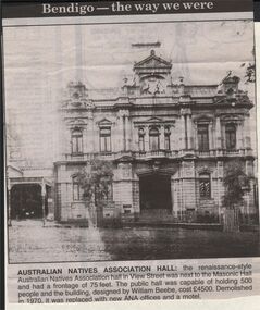
Newspaper - JENNY FOLEY COLLECTION: AUSTRALIAN NATIVES ASSOCIATION HALL
Bendigo Advertiser "The way we were" from 1999. Australian natives association hall: the renaissance-style Australian natives association hall in View Street was next to the Masonic Hall and had a frontage of 75 feet. The public hall was capable of holding 500 people and the building designed by William Beebe, cost 4,500 pounds. Demolished in 1970, it was replaced with new ANA offices and a motelnewspaper, bendigo advertiser, the way we were -
 Ballarat Tramway Museum
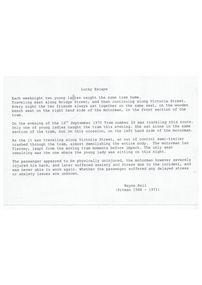
Document - Report, Wayne Kell, "Lucky Escape", 2020
Yields information accident between tram 20 and a semi trailer and the two people on the tram at the time.Report - half A4 sheet - printed - titled "Lucky Escape", written by Wayne Kell 2020, about the escape of a lady passenger from serious injury the night 16-9-2021 - about tram 20 demolished by a truck near the Victoria St terminus. The Motorman Ian Tierney never worked again. See Reg Item 551 and others for further details and the name of the lady. trams, tramways, accidents, 20, collision, victoria st -
 Melbourne Tram Museum
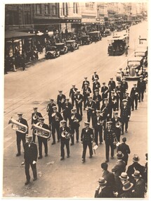
Photograph - Black & White Photograph/s, mid 1930s
Black and white photographs of a band marching across the intersection of Bourke and Swanston about mid-1930. Has a cable set descending the hill. In the background is a number of parked motor vehicles. The band is followed by a number of cars and is being watched by some people on the corner. The buildings on the top left were later demolished to make way for the Foys building. The arches of the Esquire cinema in the background are visibletrams, tramways, bourke st, bands, swanston st, cable trams -
 Port Melbourne Historical & Preservation Society
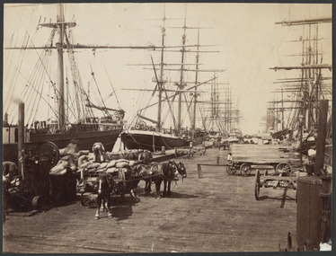
Photograph - Town Pier, Sandridge, J W Lindt, 1870s
COPYRIGHT State Library Victoria (image b46977) Town Pier, Sandridge approx 1876-1894. A competitor to Railway Pier but without the rail facility. In the 20th Century it became limited to timber or collier ships. Pier demolished in 1950s. This image shows horse-drawn wagons being loaded and many sailing ships docked in the background. Image used in PMHPS calendar 2015 (July)piers and wharves - town pier, transport - horse, transport - shipping -
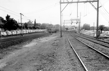 Surrey Hills Historical Society Collection
Photograph, Surrey Hills Station and car park
There are 3 tracks; the third track was built in 1971, which gives an approximate date for the photo. At this time the original station buildings were demolished and replaced by buildings constructed from concrete bricks and a second subway replaced the overhead footbridge. According to Roderick Smith, a local railway enthusiast, originally there had been 3 railway houses at the Mont Albert end of the northern car park. These were demolished to extend the car park. Certainly 8 Bedford Avenue, built as the station master's house was demolished at this time. The palm tree had been planted in the station master's front garden and was retained in a small garden bed within the car park. A black and white photograph of a station with cars parked on both sides of the 3 tracks. A Harris train is departing the station heading towards Mont Albert. A palm tree is prominent in the station car park to the north.1971, surrey hills station, railway stations, car parks, public transport, trains, railway lines, palm tree -
 Phillip Island and District Historical Society Inc.
Photograph
Phillip Island suspension Bridge built 1938/1940 - demolished 1970. Part of an album compiled and donated by Mrs Helen Jansson.Print of Phillip Island Suspension Bridge. Aerial view showing Jetties at left with sweep of sandy beaches middle to top left.No. 1. Phillip Island Bridge, Victoria. Airapy Photolocal history, photography, photographs, slides, film, civil engineering, bridges, jetties, phillip island suspension bridge, black & white photograph, mrs. helen jansson, suspension bridges, phillip island -
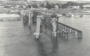 Phillip Island and District Historical Society Inc.
Photograph, Phillip Island Bridge, 1968/9
1969 2nd Phillip Island Bridge under construction. Suspension Bridge demolished early 1970 From the Jack Jenner CollectionConcrete stanchions and scaffolding of new Bridge part built.(opened 1969). Taken from other half looking towards San Remo.local history, photographs, civil engineering, bridges, phillip island bridges, black & white photograph, jack jenner collection, public construction -
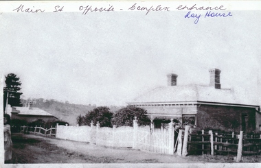 Greensborough Historical Society
Photograph - Digital image, Roy house 1, 1930c
Photograph of the Roy house in Main Street Greensborough. This house was situated opposite the present entrance to Greensborough Plaza, but has been demolished. An early view of the residential area which is now a commercial strip.Digital copy of black and white photograph.Written on front of photograph: "Main St. opposite complex entrance - Roy house"roy family -
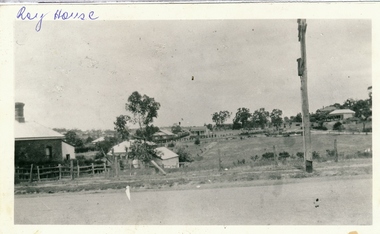 Greensborough Historical Society
Photograph - Digital image, Roy house 2, 1930c
Photograph of the Roy house in Main Street Greensborough. This house was situated opposite the present entrance to Greensborough Plaza, but has been demolished. An early view of the residential area which is now a commercial strip.Digital copy of black and white photograph.Written on front of photograph: "Roy house"roy family, main street greensborough -
 Greensborough Historical Society
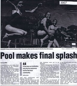
Newspaper clipping, Hanna Mills, Pool makes final splash, by Hanna Mills, 2006_11
The 42 year old Greensborough swimming pool is to be demolished at the end of the 2006-07 season to make way for the new aquatic centrePhotocopy of newspaper articleswimming pools greensborough -
 Greensborough Historical Society
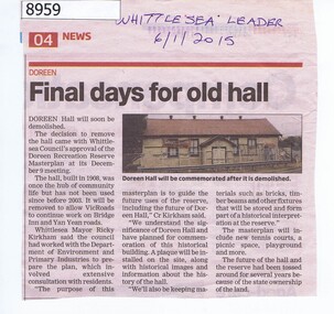
Article - Newspaper Clipping, Whittlesea Leader, Final days for old hall Doreen, 06/01/2015
In 2015 the Doreen Hall was demolished as part of the Doreen Recreation Reserve masterplan and to allow works on Bridge Inn and Yan Yean Roads.Newspaper Clipping, text and colour imagedoreen, whittlesea, doreen community hall -
 Eltham District Historical Society Inc
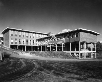
Photograph, Hugh Fisher, Eltham - Shire Office from rear, 1965
Completion of stage one of new Eltham Shire Office, showing view from the rear in 1965. They were demolished in August 1996. This photo forms part of a collection of photographs gathered by the Shire of Eltham for their centenary project book, "Pioneers and Painters: 100 years of the Shire of Eltham" by Alan Marshall (1971). The collection of over 500 images is held in partnership between Eltham District Historical Society and Yarra Plenty Regional Library (Eltham Library) and is now formally known as 'The Shire of Eltham Pioneers Photograph Collection.' It is significant in being the first community sourced collection representing the places and people of the Shire's first one hundred years.Digital imagesepp, shire of eltham pioneers photograph collection, eltham, eltham shire office -
 Eltham District Historical Society Inc
Photograph, Margaret Ball, 109 Bible Street (southwest corner Arthur and Bible Streets), Eltham, June 1999, 1999
Original house demolished in late 1990s. Original house believed to be the home of the Bunkers from the early 1900s till c.1920.The Margaret Ball (Pre 1960s Houses) Collection was a personal project initiated to mark the year 2000 and arose as a result of the disappearance of many pre-1960s parts of Eltham due to development. Approximately 200 pre-1960s style houses that were left in Eltham between Main Road and east to Bible Street, between Cecil Street to the north and south to Dalton Street were photographed in late 1999. Not all of the houses could be photographed; some because the garden or trees blocked the view of the house, others because of rubbish or cars were in the way, some because people were working on the house or in the gardens at the time.Roll of 35mm colour negative film, 10 stripsFuji 200eltham, houses, streets, margaret ball (pre 1960s houses) collection, arthur street, bible street -
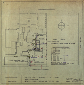 Federation University Historical Collection
Plan - Plans, Ballarat School of Mines New Workshops, 1944, 17/11/1944
This building has been demolished to make way for new buildings along Albert Street. According to E.J. Barker this was Metal Fabrication.Plans (dyeline) for new building along the Ballarat School of Mines Albert Street frontage .1) Ballarat School of Mines New Workshops .2) as above Scale 1:480 WGS 84 37 degrees 33 feet 54 inches south 143 degrees 50 feet 30 inches eastSheet No 3 F.G.B.ballarat school of mines, metal fabrication, albert street, buildings, plan, heat engines room, model mine, blacksmiths shop, blacksmithing, carpenters shop, engineering shope, percy everett -
 Port Melbourne Historical & Preservation Society
Postcard - Port Melbourne series, Alison Kelly, 1991
Both photographers were concerned about heritage places soon to be demolished or altered. Printing of the postcards was paid for by Port Melbourne Council.From a set of nine colour postcards featuring heritage places on the Port waterfront. Images by Alison KELLY (nos 4-9) and James LAURITZ (nos 1-3) 1991 1. Aerial photo of Bay St. 2. Starch factory shell. 3. Sunset over Station Pier. 4. Beacon (outer) 5. Gatehouse Station Pier. 6. Seamen's Mission building. 7. Abel Tasman ferry. 8. Old Eastern kiosk. 9. Centenary Bridge stairway.piers and wharves - station pier, piers and wharves - princes pier, piers and wharves - lagoon pier, beacons, built environment, transport - ferries, missions to seamen, james lauritz, alison kelly, abel tasman -
Tatura Irrigation & Wartime Camps Museum
Photograph - copy, Catholic Church Tatura 1888, c1892
Copy of original photograph of 1st Roman Catholic Church in Tatura c1888. Demolished 1912. Replaced by present Sacred Heart Church.Black and white photograph of exterior of 1st Roman Catholic Church Tatura and picket fence on back - 1st Catholic Church 1888sacred heart church tatura, 1st roman catholic church tatura 1888 -
Uniting Church Archives - Synod of Victoria
Furniture - Communion rail
Communion set used in The Wesleyan Jubilee Church Toorak Church which was built in 1877. The church was illegally demolished by developers in 1985.Dark timber and brass communion rail. The rail has timber top and bottom rails together with corner and middle supports. It has a brass finish and vine motif. the wesleyan jubilee church toorak -
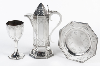 Uniting Church Archives - Synod of Victoria
Communion set
Communion set used in The Wesleyan Jubilee Church Toorak Church which was built in 1877. The church was illegally demolished by developers in 1985.4 piece decorated silver communion set: S11.1 Communion flagon; S11.2 Chalice; S11.3 Chalice; S11.4 Octagonal paten. The set has been identified as coming from The Wesleyan Jubilee Church Toorak by a photograph of its alter.the wesleyan jubilee church toorak -
 Stawell Historical Society Inc
Photograph, Mr Joseph Shilton's home in Main Steet Stawell 1870
Home of Joseph Shilton 1870 – Later ( Holy Trinity Vicarage Stawell 1922/23). Main Street Stawell Now demolished.stawell building -
 Kew Historical Society Inc
Photograph - Kew Recreation Hall, Wellington Street, c.1950
The Kew Recreation Hall was opened in 1880. For eighty years it was a major venue for concerts, performances, dances and civic events. It was demolished in 1960.This work forms part of the collection assembled by the historian Dorothy Rogers (1905-1973), donated to the Kew Historical Society by her son in 2015. The manuscripts, photographs, maps, and documents were sourced by her from both family and local collections or produced as references for her print publications. Many were directly used by Rogers in writing ‘Lovely Old Homes of Kew’ (1961) and 'A History of Kew' (1973), or the numerous articles on local history that she produced for suburban newspapers. Most of the photographs in the collection include detailed annotations in her hand. The Rogers Collection provides a comprehensive insight into the working habits of a historian from the 1960s to the 1970s. Front view, from Wellington Street, of the former Kew Recreation Hall. The 1880 weatherboard building has a long covered entrance leading to the gabled facade. A smaller gabled room protrudes from one side of the facade. At this stage, the decorative features: gables, brackets, finials, etc were still preserved. The triple window would have been a major source of light for the interior. It appears to have an upper balcony in front of the window. Annotation verso: "28. Kew Recreation Hall prior to demolition. Built about 1880."dorothy rogers, kew recreation hall, buildings -- wellington street (kew) -
 Kew Historical Society Inc
Photograph - Kew Recreation Hall, Wellington Street, c.1950
The Kew Recreation Hall was opened in 1880. For eighty years it was a major venue for concerts, performances, dances and civic events. It was demolished in 1960.This work forms part of the collection assembled by the historian Dorothy Rogers (1905-1973), donated to the Kew Historical Society by her son in 2015. The manuscripts, photographs, maps, and documents were sourced by her from both family and local collections or produced as references for her print publications. Many were directly used by Rogers in writing ‘Lovely Old Homes of Kew’ (1961) and 'A History of Kew' (1973), or the numerous articles on local history that she produced for suburban newspapers. Most of the photographs in the collection include detailed annotations in her hand. The Rogers Collection provides a comprehensive insight into the working habits of a historian from the 1960s to the 1970s. Oblique view, from Wellington Street, of the former Kew Recreation Hall. The 1880 weatherboard building has a long covered entrance leading to the gabled facade. A smaller gabled room protrudes from one side of the facade. At this stage, the decorative features: gables, brackets, finials, etc were still preserved. The triple window would have been a major source of light for the interior. It appears to have an upper balcony in front of the window. Annotation verso: "Kew Recreation Hall. Built ca. 1880 (Photo prior to demolition in 1960".dorothy rogers, kew recreation hall, buildings -- wellington street (kew) -
Canterbury History Group
Photograph - "Roquebrune" corner Canterbury Road and Gascoyne Street Canterbury, c1920
The house was built in 1912 or 1914 for G. H. Tarrant and was demolished in 1971 to make way for the Baptist Nursing Home. Now apartments.Sepia photograph of three people sitting in the front garden of "Roquebrune" corner of Canterbury Road and Gascoyne Street Canterbury. canterbury, canterbury road, gascoyne street, edwardian style, roquebrune, nursing homes, baptist nursing home