Showing 1567 items
matching documents - maps
-
 Clunes Museum
Map, F.W. NIVEN 34 STURT ST. BALLARAT & EMBOSSER
... HISTORY DOCUMENT MAPS MINING - MAPS SCROLL - SURVEVOR MAP AND PLAN ...SCROLL - SURVEVOR MAP AND PLAN OF NEW CRESWICK GOLD FIELDS SURFACE LEVELSlocal history, document, maps, mining - maps -
Clunes Museum
Map - MAPS
... HISTORY DOCUMENT MAPS TALBOT CLUNES SHIRE ORIGINAL MAP SHIRE ...ORIGINAL MAP SHIRE OF TALBOT AND CLUNES. LOCALITY PLAN, SEALED ROADS, BITUMEN ROADS, GRAVEL OR SAND ROADS, UNMADE OR PART FORMED ROADS.local history, document, maps, talbot, clunes shire -
Clunes Museum
Map
... JULY 21ST,1873 local history document maps clunes water ...MAP DATED JULY 21ST,1873MAP OF CLUNES WATER SUPPLY, TOWNSHIP OF CLUNES, SHOWING SYSTEM OF DISTRIBUTION.TOWNSHIP OF CLUNESlocal history, document, maps, clunes water -
Clunes Museum
Map, Oct-74
... HISTORY DOCUMENT MAPS MAPS MAP OF CLUNES STREETS/TOWNSHIP - SCALE ...MAP OF CLUNES STREETS/TOWNSHIP - SCALE IN CHAINSlocal history, document, maps, maps -
 Peterborough History Group
Document - Explorers of Australian coastline
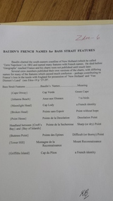
information pertaining to Captain Cook and French sailor Baudin. Includes French names which he assigned to coastal features.Outlines early European observation of the coastline.Newspaper clipping, copies mapsbaudin, peterborough, peterborough history, le geographe -
 Peterborough History Group
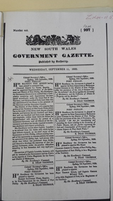
Document - Establishment of Peterborough
... massacre bay Copies of maps, pages of books and hand drawn map ...Details progress of establishment of the district and the town Information about the town being Gazetted; Massacre Bay informationCopies of maps, pages of books and hand drawn mapbaradh clan, peterborough, peterborough history, buckley creek run, massacre bay -
 Peterborough History Group
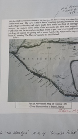
Document - Peterborough survey, Heytesbury District
... Maps, photocopies Document Peterborough survey, Heytesbury ...About Peterborough town and the surrounding Council districts, coastal survey and mapshistory of the development of the townMaps, photocopiesflaxman hill, peterborough history, heytesbury, peterborough 3270 -
 Peterborough History Group
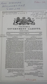
Document - Survey of Town of Peterborough, 2014
... Proclamation of road district and Shires, Map of original town blocks ...Proclamation of road district and Shires, Map of original town blocks and ad for SaleDisplays original township settlement and layoutPhotocopies, copies of maps, peterborough history, peterborough 3270 -
Peterborough History Group
Document - District families and organisations
... Hill School Peterborough School photocopies, maps Document ...Local families' history, school, post officephotocopies, mapspeterborough history, croft family, thomas croft, peterborough post office, wallaby hill school, peterborough school -
 Peterborough History Group
Document - Maps, tourist information
... 3270 Photocopies, copies of maps, newspaper clipping Document ...Council boundaries, past tourist information, past mapsHistoric town information and mapsPhotocopies, copies of maps, newspaper clippingpeterborough history, peterborough 3270 -
Stawell Historical Society Inc
Document - Report, Nicole Start, Conservation Status of Roadsides in the Shire of Stawell, 1991
Covers: Shire, roadsides, Assessment: Species, Flora, Grazing, Cropping, Gravel, Noxious weeds, Firebreaks, Road Design. With loos maps X 2 in back. Author Nicole StartPlastic Front Cover. Yellow Paper with Photo of a country road.Nicole Start Biological and Chemical Sciences Ballarat University Collage December 1991 -
Koorie Heritage Trust
Booklet, Baxter, Bruce [et al.]. (Aboriginal History Program), Matakupat : the Aboriginal history of the Swan Hill area, 1990
Traditional Aboriginal Society was an oral culture so that the history, stories, and songs and knowledge of Spirituality, Laws, Customs and Values were communicated verbally for thousands of years. The invasion of Europeans caused destruction of tribal groups by disease and killings. It limited the use of language, exchange of stories, land use and the important performance of rituals and ceremonies. Europeans used their world view as a mirror and through their observations, documents, diaries, reports and stories were full of racist comments and ignorant opinions of a lifestyle and culture of which they had little understanding. This book was the result of many months of research by a group of Swan Hill Aboriginal Educators. It is an attempt to present limited information about the history and lifestyles of the Wemba Wemba and Wathi Wathi people, the Tribes of the Swan Hill and Lake Boga areas.20 p. : ill., map ; 21 cm.Traditional Aboriginal Society was an oral culture so that the history, stories, and songs and knowledge of Spirituality, Laws, Customs and Values were communicated verbally for thousands of years. The invasion of Europeans caused destruction of tribal groups by disease and killings. It limited the use of language, exchange of stories, land use and the important performance of rituals and ceremonies. Europeans used their world view as a mirror and through their observations, documents, diaries, reports and stories were full of racist comments and ignorant opinions of a lifestyle and culture of which they had little understanding. This book was the result of many months of research by a group of Swan Hill Aboriginal Educators. It is an attempt to present limited information about the history and lifestyles of the Wemba Wemba and Wathi Wathi people, the Tribes of the Swan Hill and Lake Boga areas.1. aborigines, australian -- victoria -- swan hill -- history -- juvenile literature. 2. aborigines, australian -- victoria -- swan hill -- social life and customs -- juvenile literature. i. baxter, bruce. ii. title., other: wemba wemba tribe -- wathi wathi tribe -- aboriginal educators. -
Koorie Heritage Trust
Document - Printed Sheets, Aboriginal Affairs Victoria, Proposed Victorian Aboriginal cultural Heritage Legislation: Discussion Paper, 1997
"The Victorian Government is proposing new legislation to protect the State's significant significant Aboriginal cultural heritage. This legislation will replace the existing 'Archaeological and Aboriginal Relics Preservation Act 1972' and enabled the Commonwealth Government to consider repealing Part IIA of the 'Aboriginal and Torres Strait Islander Heritage Protection Act 1984 (Cth). This paper outlines key issues to be considered during the preparation of the new legislation, as a basis for consultation with interested parties during August and September 1997."23 p.; appendices; map; refs.; 30 cm."The Victorian Government is proposing new legislation to protect the State's significant significant Aboriginal cultural heritage. This legislation will replace the existing 'Archaeological and Aboriginal Relics Preservation Act 1972' and enabled the Commonwealth Government to consider repealing Part IIA of the 'Aboriginal and Torres Strait Islander Heritage Protection Act 1984 (Cth). This paper outlines key issues to be considered during the preparation of the new legislation, as a basis for consultation with interested parties during August and September 1997."aboriginal australians -- antiquities -- law and legislation -- victoria. | sacred sites (aboriginal australian) -- victoria. | cultural property -- protection -- law and legislation -- victoria. | cultural heritage - protection - law and legislation | government policy - state and territory - victoria. -
Koorie Heritage Trust
Document - Printed Sheets, Barwick Diane E, Changes in the Aboriginal Population of Victoria, 1863-1966. (extract), 1971
Reviews Aboriginal population and the effects of white settlement on population together with the Aboriginal Protection Board and the Missions influences on population, Government policty and conditions to 1966.288-314 P.; refs.; map; figs.; tables; 30 cm.Reviews Aboriginal population and the effects of white settlement on population together with the Aboriginal Protection Board and the Missions influences on population, Government policty and conditions to 1966. victorian-aborigines - population 1863-1966., board for the protection of aborigines-history., aborigines, victoria-population decline. -
Koorie Heritage Trust
Document - Printed Sheets, Bennett, Catherine et al, Report on Aboriginal Skeletal Remains from Tarwin Meadows, South Gippsland - site number 80201/043, 1986
30 P.; appendices; maps; figs.; tables; plates; 32 cm.skeletal remains-aboriginal-tarwin meadows-south gippsland, anthropology-aboriginal-south gippsland., victorian archaeological survey-aboriginal skeletal remains -
Koorie Heritage Trust
Document - Printed Sheets, Beaglehole, J. C, The Endeavour Journal of Joseph Banks 1768-1771 Volume II
Figs.; maps; footnotes; 21 cm.australia-east coast (nsw) fauna and flora., australia-exploration. -
Koorie Heritage Trust
Document - Printed Sheets, Beauglehole, A . C, The distribution and conservation of native vascular plants in the Victorian Mallee, 1979
ii, 99 p. : ill., map (fold.col.in pocket) ; 21x30 cm.indigenous vascular plants. distribution. victoria. mallee region. | botany -- victoria -- mallee. -
Koorie Heritage Trust
Book, Bessant, B, The land hunger - commentary and documents, 1980
Bob Bessant draws on legislative, administrative as well as private documents to show how the vast 'uninhabited' continent of Australia represented a golden opportunity for Europeans who otherwise would have no chance to gain wealth and power. The result is an analysis of the pre-occupation with land by both Australian and British interests for a century.iii-v; 90 p.; ill; maps; index; bib.; ref.; 26 cm.Bob Bessant draws on legislative, administrative as well as private documents to show how the vast 'uninhabited' continent of Australia represented a golden opportunity for Europeans who otherwise would have no chance to gain wealth and power. The result is an analysis of the pre-occupation with land by both Australian and British interests for a century.land settlement -- australia -- history. -
Koorie Heritage Trust
Book, Buggy, Terry et al, Race relations in colonial Australia : an enquiry approach, 1982
A history text for secondary students. It explores three main areas of conflict in 19th century, Aboriginal relations with white settlers in Sydney area; Poonindie; Coranderrk; uses period documents.vi, 154 pages : illustrations, facsimiles, maps, portraits ; 26 cm.A history text for secondary students. It explores three main areas of conflict in 19th century, Aboriginal relations with white settlers in Sydney area; Poonindie; Coranderrk; uses period documents.australia -- race relations | race relations. australia, 1800-1900. for schools | australia -- race relations. | settlement and contacts - colonisation - 1851- | education - indigenous studies - secondary | race relations - violent - massacres, murders, poisonings etc. - to 1900 | poonindie (west sa si53-11) | southwest new south wales (sw nsw si54, si55) | sydney (nsw si56-05) | healesville / coranderrk (e vic yarra valley sj55-06) | -
Koorie Heritage Trust
Book, Abbie, A. A, The original Australians, 1969
In this carefully documented work he presents an overall picture of the Aborigines; their physical and mental characteristics, tribal customs, sexual behaviour and diet; and discusses the social situation of Aborigines today, and their prospects for the future.xiii-xx; 271p.;illus.; footnoted, bibliography; index; maps; figs.;18 cm.In this carefully documented work he presents an overall picture of the Aborigines; their physical and mental characteristics, tribal customs, sexual behaviour and diet; and discusses the social situation of Aborigines today, and their prospects for the future.aborigines, australian-physical characteristics, aborigines, australian-social life and customs, aborigines, australian - migration, anthropology-aboriginals, australian., magic; artisic culture; ceremonies; beliefs. -
Koorie Heritage Trust
Document - Report, Birckhead, Jim, Aboriginal involvement in parks and protected areas : papers presented to a conference organised by the Johnstone Centre of Parks, Recreation and Heritage at Charles Sturt University, Albury, New South Wales 22-24 July 1991, 1992
Highlights significant differences in Aboriginal and non-Aboriginal notions of land and land management.xiv, 390 p. : ill., maps, ports. ; 27 cm.Highlights significant differences in Aboriginal and non-Aboriginal notions of land and land management.national parks and reserves -- australia -- management -- congresses. | land use -- australia -- management -- congresses. | aboriginal australians -- land tenure -- congresses. | aboriginal australians -- antiquities -- congresses. -
Koorie Heritage Trust
Document - Printed Sheets, McBryde, I et al, The Distribution of Greenstone Axes in Southeastern Australia: preliminary report: Mankind Vol. 10 No. 3 June 1976: 163-174 "Wil-im-ee Moor-ring" or Where do axes come from? Mankind Vol. 11 1978: 354-82, 1976
Two papers outlining the greenstone sites in Victoria, their distribution and role in exhange in the communities.163-174 P.; maps; figs.refs.; bib. and vol 11 354-382 P.; maps; notes; graphs;tables; bib. Two papers outlining the greenstone sites in Victoria, their distribution and role in exhange in the communities. greenstone - quarry sites - victoria., aboriginal greenstone ?xes - south-eastern australia - sites., exchanged - greenstone - aborighinals, victoria. mount camel. -
Whitehorse Historical Society Inc.
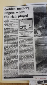
Document, East Burwood reserve, 1992
History and map of East Burwood Reserve - includes details of acquisition of landHistory and map of East Burwood Reserve - includes details of acquisition of landHistory and map of East Burwood Reserve - includes details of acquisition of landcity of nunawading, east burwood reserve, burwood highway, burwood east, nos 292 - 336 -
 Whitehorse Historical Society Inc.
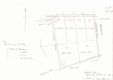
Document, Subdivisions 1859, nd
Sketch map of subdivisions of 1859.Sketch map of subdivisions of 1859. Allotment 126 and portions of 125, 126 and 130, including 'Village of Studley', 'Village of New Brunswick' and two unnamed. Information from Mr McComb, retired surveyor; sketch and notes. Areas near railway line east of Mitcham Station and North East corner of Canterbury and Mitcham Roads. Refer map A - SP 110.Sketch map of subdivisions of 1859.land subdivision, heatherdale road, mitcham, purches street, mitcham road, vermont, canterbury road, whitehorse road, brunswick road, creek road, centre road, studley village, new brunswick village -
 Whitehorse Historical Society Inc.
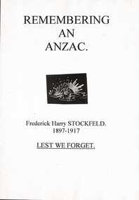
Document - Report, Frederick Henry Stockfield, 1/06/1997
Photocopy of a school assignment. It describes a number of local War Memorials and gives information about Frederick Henry Stockfield who is listed on the Mitcham War Memorials. His family lived in Blackburn Road Blackburn and he had worked picking fruit. He was an artillery man who trained in England and fought in the Third Battle of Ypres. He died of wounds on 21/9/1917 and is buried in the Military Huts Cemetery in Dickenbuscg, Belgium. Photographs of his grave and the cemetery are included. There is information about the life of a Gunner and some about his family. Photographs. Maps. Approx 38 pagesstockfield, frederick harry;, world war 1914-1918. battle of ypres, war memorials -
 Whitehorse Historical Society Inc.
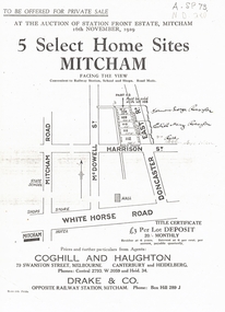
Document, 5 Select Homes Sites Mitcham, 16/11/1929 12:00:00 AM
Auction of land in Mitcham.Auction of land in Mitcham. Includes schetch map of locations and names of purchasersAuction of land in Mitcham. auction, station front estate, mitcham road, mcdowell street, doncaster east road, whitehorse road, coghill & haughton estate agents, drake & co estate agents, roeszler, norman george, edith mary, reid harrison street -
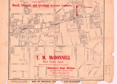 Whitehorse Historical Society Inc.
Document, T. M. McDonnell, 1929
Correspondence of T.M. McDonnellCorrespondence of T.M. McDonnell dated 16 October 1929, typed on headed stationery with a 'map of Mitcham, Tunstall and Blackburn'.Correspondence of T.M. McDonnell mcdonnell, t.m., mitcham, nunawading, blackburn, forest hill, vermont -
Whitehorse Historical Society Inc.
Document, Vermont pre 1890, 1985?
Short history of Vermont, pre 1890. Nunawading Historical Society competition, first prize, open section. With maps and photographs.Short history of Vermont, pre 1890. Nunawading Historical Society competition, first prize, open section. With maps and photographs.Short history of Vermont, pre 1890. Nunawading Historical Society competition, first prize, open section. With maps and photographs.vermont, nunawading -
Whitehorse Historical Society Inc.
Document, What happened to Norwich?
Norwich, consisting of 475 acres in the Parish of Nunawading, County of Bourke, found on a land sale map in the La Trobe collection of Vale maps.Norwich, consisting of 475 acres in the Parish of Nunawading, County of Bourke, found on a land sale map in the La Trobe collection of Vale maps. Research by Jean Uhl into the fate of the proposed township.Norwich, consisting of 475 acres in the Parish of Nunawading, County of Bourke, found on a land sale map in the La Trobe collection of Vale maps. local history, uhl, jean, parish of nunawading, norwich village, vermont, lobb, john, graham, thomas -
Whitehorse Historical Society Inc.
Document, Kelly Gang Film, 1994
... (with sketch map) McDonnell Family The Story of the Kelly Gang (Film ...Manuscript notes with typed copy. The 'Kelly Gang' film at 1320ft long which ran for over an hour is longer than the film 'The Great Train Robbery' (1903) claimed as the first full length picture made in the world.Manuscript notes with typed copy. The 'Kelly Gang' film at 1320ft long which ran for over an hour is longer than the film 'The Great Train Robbery' (1903) claimed as the first full length picture made in the world. 'Lowberry' timber house owned by McDonnells (with sketch map)Manuscript notes with typed copy. The 'Kelly Gang' film at 1320ft long which ran for over an hour is longer than the film 'The Great Train Robbery' (1903) claimed as the first full length picture made in the world. mcdonnell family, the story of the kelly gang (film), films