Showing 1088 items matching "falls creek"
-
 Kiewa Valley Historical Society
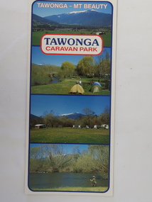
Brochure - Tawonga Caravan Park, Tawonga - Mt Beauty
... of Mt Beauty and 30 km from Falls Creek. ... and 30 km from Falls Creek. Tawonga Caravan park has always been ...Tawonga Caravan park is on the Kiewa River situated north of Mt Beauty and 30 km from Falls Creek. Tawonga Caravan park has always been popular for families and fishermen with plenty to do.Colored cardboard brochure with 3 small photos on the front and information printed on the back with a small map.tawonga caravan park, trout fishing -
 Falls Creek Historical Society
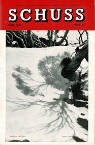
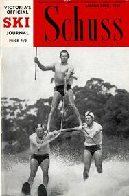
Journal - Schuss Vol. 20. No. 4 June 1954
... to the Falls Creek Area in this issue include:- Page 127 features.... Items related to the Falls Creek Area in this issue include ...Schuss was advertised as Victoria’s Official Ski Journal It was issued monthly from 1935 to 1961 except during the war when summer issues covered two months. This continued after the war, but it averaged 10 issues annually over its 25 year life. Schuss was published by the Ski Club of Victoria which had a membership of 38 Ski Clubs and demanded to be recognised as the prime authority on skiing in the state. The other 30 ski clubs with 85% of the members disagreed and the politics of skiing became heated. These clubs formed the Federation of Victorian Ski Clubs with their own journal, Ski Horizon. With the establishment of the Victorian Ski Association, Ski-Horizon published its last issue in Nov - Dec. 1955 and the role of the official journal was fully taken over by “Schuss”. This item is significant because it contains stories, images and information documenting the development of the ski industry in Victoria.The journal features stories and events chronicling developments in Victoria and internationally. Items related to the Falls Creek Area in this issue include:- Page 127 features a photo of Skyline Lodge taken by S. Flattely with the following text " THE S.C.V.'s SKYLINE LODGE, FALLS CREEK, BOGONG HIGH PLAINS This Lodge in its setting of alpine grandeur, with the impressive outlook to the Spion Kopje Spur, is one of the most comfortable cabins in our mountains. Some vacancies in July and Spring, when snow is still plentiful in this area, Book at S.C.V. Office. Page 134 outlines information for visitors to Skyline including transport, garbage, safety, traffic rules and the use of the lodge.schuss journal, the ski club of victoria, skyline lodge -
 Falls Creek Historical Society
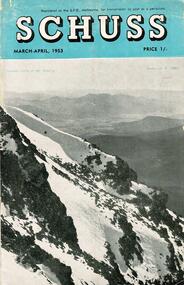
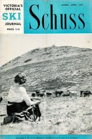
Journal - Schuss Vol. 19. No. 2 March - April 1953
... to the Falls Creek Area in this issue include:- Cover - Features...Falls Creek Historical Society Slalom Street Falls Creek ...Schuss was advertised as Victoria’s Official Ski Journal It was issued monthly from 1935 to 1961 except during the war when summer issues covered two months. This continued after the war, but it averaged 10 issues annually over its 25 year life. Schuss was published by the Ski Club of Victoria which had a membership of 38 Ski Clubs and demanded to be recognised as the prime authority on skiing in the state. The other 30 ski clubs with 85% of the members disagreed and the politics of skiing became heated. These clubs formed the Federation of Victorian Ski Clubs with their own journal, Ski Horizon. With the establishment of the Victorian Ski Association, Ski-Horizon published its last issue in Nov - Dec. 1955 and the role of the official journal was fully taken over by “Schuss”. This item is significant because it contains stories, images and information documenting the development of the ski industry in Victoria.The journal features stories and events chronicling developments in Victoria and internationally. Items related to the Falls Creek Area in this issue include:- Cover - Features a photo by H.Gibbs titled "Western Cliffs of Mt. Bogong" Page 65 - BOB HYMANS reported news of Falls Creek. At his own Ski School, notable improvements to accommodation have been made and additions to the building itself, which will make it very much more comfortable and serviceable to visitors. Water supply and heating are amongst the items in hand. Bob has acquired a Land Rover which will be a power of assistance to him in maintaining fresh supplies and in servicing his project generally. Kiewa Valley Ski Club members are making splendid progress with the erection of their Lodge. This is the latest building addition in that area and raises the number of clubs resident there to nine. Nissen Ski Tow members intend to operate their tow on the upper slopes of Falls Creek every day during the coming season that conditions permit. They are to be warmly commended on their enterprise. Page 65 - Advertisement for Bob Hymans' Ski School and Lodgeschuss journal, bob hymans, kiewa valley ski club, nissen tow -
 Falls Creek Historical Society
Card - Zali Steggal Festive Season, 2020
... of Red Onion, Falls Creek. The card was sent by Zali Steggal... of Red Onion, Falls Creek. The card was sent by Zali Steggal OAM ...This item is from the private collection of George Shirling of Red Onion, Falls Creek. The card was sent by Zali Steggal OAM, a four time Olympian and Australia’s most successful alpine skier. She competed in Winter Olympics at Albertville 1992, Lillehammer 1994, Nagano 1998, Salt Lake City 2002. After retiring from competitive sport in 2002, Zali studied Law as well as Community Media and Communication. She entered politics as a Federal Government MP in 2019. George Shirling arrived in Falls Creek in 1962. He engaged Phil Nowell to build the original Koki Alpine Lodge which opened in 1965 with 14 beds. George operated the lodge with Michael “Baldy” Blackwell as manager. He also graduated in sport psychology in 1981 and was invited to become team psychologist for the Australian Winter Olympic team which went to Albertville, France, in 1992. He later owned the Red Onion Chalet. George credited the success of Koki to “Baldy” Blackwell. “Baldy” and Phil Nowell started the Trackers Mountain Lodge in partnership during the 1980s. In 1971 George sold Koki Lodge to Sigi Doerr. In 2024 the renamed Koki Alpine resort remains a highly popular destination in Falls Creek. George Shirling passed away on 27th February 2023. He had remained actively involved in Falls Creek and was generous with his time and knowledge, always an amazing supporter of The Falls Creek Museum and Falls Creek Village.This card is significant because it was sent to George Shirling by Australia's most successful alpine skier.A coloured card for the Festive Season sent to George Shirling by Zali Steggal in 2020. The front page includes the text "From piste to Parliament" acknowledging her former ski career. The centre page contains suggestions for activities to "stay local" over the holiday season as a way to assist local recovery after COVID. The back page suggests 10 tips for "being green this Christmas."george shirling, zali steggal, australian winter olympians -
 Falls Creek Historical Society
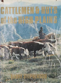
Book - Cattlemen & Huts of the High Plains, Harry Stephenson, 1980
... indicates it had been given to Ore Frueauf of Falls Creek.... indicates it had been given to Ore Frueauf of Falls Creek. Cattlemen ...This book records the development of Victoria's alpine regions by the pioneer cattlemen. They came from the Monaro in the 1830s to reach the Plains of Omeo while others advanced up the Murray tributaries to discover the Bogong High Plains in the 1830s and the Gippslanders moved their herds to Alpine pastures in the 1860s. The cattlemen, the snow plain pastures, the mountain scene and the bush huts are described and illustrated in this volume. It records an era in Australia whose story is becoming lost.This volume of 350 pages includes 34 maps, 326 illustrations and diagrams. It has a brown cloth with white lettering and a pictorial jacket featuring cattlemen on the High Plains. It includes an index and bibliography. The front page has an inscription which indicates it had been given to Ore Frueauf of Falls Creek.non-fictionThis book records the development of Victoria's alpine regions by the pioneer cattlemen. They came from the Monaro in the 1830s to reach the Plains of Omeo while others advanced up the Murray tributaries to discover the Bogong High Plains in the 1830s and the Gippslanders moved their herds to Alpine pastures in the 1860s. The cattlemen, the snow plain pastures, the mountain scene and the bush huts are described and illustrated in this volume. It records an era in Australia whose story is becoming lost.victorian high country, mountain cattlemen, victorian high plains -
 The Beechworth Burke Museum
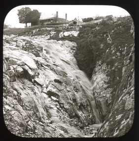
Photograph - Lantern Slide, c1900
... spring creek falls... was built at the top of the Spring Creek falls by Russian-born Louis... was built at the top of the Spring Creek falls by Russian-born Louis ...This image shows the gorge adjacent to Beechworth in approximately 1900. Although the exact location of the photograph is yet to be determined, the present-day Beechworth Gorge Walk includes views of the Cascades at the point at which Spring Creek flows into the valley on the level below. Gold-sluicing techniques in use in the town during periods of active gold extraction may have altered the landscape since the photograph was taken, however. In the 1850s a mill was built at the top of the Spring Creek falls by Russian-born Louis Chevalier, brother of artist Nicholas Chevalier. The mill supplied the town with lumber that supported the town's initial construction boom. Lantern slides, sometimes called 'magic lantern' slides, are glass plates on which an image has been secured for the purpose of projection. Glass slides were etched or hand-painted for this purpose from the Eighteenth Century but the process became more popular and accessible to the public with the development of photographic-emulsion slides used with a 'Magic Lantern' device in the mid-Nineteenth Century. Photographic lantern slides comprise a double-negative emulsion layer (forming a positive image) between thin glass plates that are bound together. A number of processes existed to form and bind the emulsion layer to the base plate, including the albumen, wet plate collodion, gelatine dry plate and woodburytype techniques. Lantern slides and magic lantern technologies are seen as foundational precursors to the development of modern photography and film-making techniques.This glass slide is significant because it provides insight into Beechworth's built environment and natural landscape in the early Twentieth Century, around the time of Australia's Federation. It is also an example of an early photographic and film-making technology in use in regional Victoria in the time period.Thin translucent sheet of glass with a square image printed on the front and framed in a black backing. It is held together by metals strips to secure the edges of the slide.burke museum, beechworth, lantern slide, slide, glass slide, plate, burke museum collection, photograph, monochrome, indigo shire, north-east victoria, spring creek falls, beechworth gorge, louis chevalier, nicholas chevalier, lumber industry, timber industry, 1850s, construction, building, mill, mills, waterfall -
 Kiewa Valley Historical Society
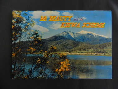
Booklet - Mt Beauty and the Kiewa Scheme x2
... cover Falls Creek with snow, lifts and skiers - one with Spion... & surrounding areas to visitors / tourists. The photos cover Falls Creek ...This booklet was produced to advertise Mt Beauty, the Kiewa Scheme & surrounding areas to visitors / tourists. The photos cover Falls Creek with snow, lifts and skiers - one with Spion Kopje Lodge. Also Tawonga Camping ground, Bogong Village, Mt Beauty Chalet, the Control panel at Kiewa Power Station, Clover Dam at No. 3 Power Station, the road to Falls Creek and a view of Mt Beauty township. The photos indicate what Mt Beauty and the Kiewa Valley and High Plains looked like c1950's during the construction of the Kiewa Hydro Electric Scheme. The area was recognised and encouraged as a tourist attraction especially Falls Creek enabling comparison with later photos and ideas. A fold down booklet postcard size of 12 colored photos - back to back of Mt Beauty, the Kiewa Scheme & surrounds. They fold in to form a front photo with title and a back card for stamp & address of addressee. On the back of the front photo are a few paragraphs describing the beauty, history and 'things to do' in the area for the visitor / tourist. mt beauty; kiewa scheme; tawonga; bogong; clover dam; kiewa valley; bogong high plains -
 Falls Creek Historical Society
Clothing - Women's Ski Wear 1970s
... year at Falls Creek, staying at Spargo's Lodge. The Martins...Falls Creek Historical Society Slalom Street Falls Creek ...This outfit was donated by Hayley Martin. It was worn by two generations of the family, Hayley's mother and later by Hayley herself. Throughout the 1960s and early 1970s the six members of the Martin Family generally spent at least a week each year at Falls Creek, staying at Spargo's Lodge. The Martins then bought a share in Diana Lodge and stayed there frequently until the late 1970s. The sweater (HEAD brand) was purchased at Molony's at Falls Creek.This item is significant as it is indicative of the apparel worn by skiers at Falls Creek in the 1960s and 1970s.Black woollen stretch pants with white line pattern. A woollen cap completes the outfit.women's ski attire, molony ski shop, cuming's ski hire -
 Falls Creek Historical Society
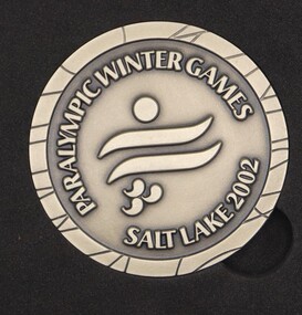
Medal - Paralympic Winter Games Salt Lake 2002 volunteer medal
... of Red Onion, Falls Creek. Salt Lake 2002 was also the first... of Red Onion, Falls Creek. Salt Lake 2002 was also the first ...This item is from the private collection of George Shirling of Red Onion, Falls Creek. Salt Lake 2002 was also the first organizing committee to integrate the planning for both the Olympics and Paralympic Games. The Paralympic Games were held from 7th to 16th March. Australia was represented at these Games by Peter Boonaerts, Bartholomew (Bart) Bunting, Michael Milton, Scott Adams, Cameron Rahles-Rahbula, Mark Drinnan. Michael Milton won gold in all four of his events – Downhill, Slalom, Giant Slalom, and Super-G, and Bart Bunting with guide Nathan Chivers won gold in two events – Downhill and Super-G, and silver in the giant slalom. Australia finished 8th overall in the gold and total medal count. George Shirling arrived in Falls Creek in 1962. He engaged Phil Nowell to build the original Koki Alpine Lodge which opened in 1965 with 14 beds. George operated the lodge with Michael “Baldy” Blackwell as manager. He also graduated in sport psychology in 1981 and was invited to become team psychologist for the Australian Winter Olympic team which went to Albertville, France, in 1992. He later owned the Red Onion Chalet. George credited the success of Koki to “Baldy” Blackwell. “Baldy” and Phil Nowell started the Trackers Mountain Lodge in partnership during the 1980s. In 1971 George sold Koki Lodge to Sigi Doerr. In 2024 the renamed Koki Alpine resort remains a highly popular destination in Falls Creek. George Shirling passed away on 27th February 2023. He had remained actively involved in Falls Creek and was generous with his time and knowledge, always an amazing supporter of The Falls Creek Museum and Falls Creek Village.This medal is significant because it represents Australia's involvement in the Winter Paralympic Games in 2002 A medal presented to volunteers at the Salt Lake City 2002 Winter Paralympic Games. The front featured the Logo of these Games which included three Tae-Geuk, a Sino-Korean term meaning 'supreme or ultimate'. It linked the flag to the previous Winter Paralympic Games held in South Korea. The reverse featured the three Tae-Geuks more prominently. On the rim the words “Mind Body Spirit” were inscribed representing the three values of the 2002 Paralympic Winter Games.On Front: Logo surrounded by PARALYMPIC WINTER GAMES / SALT LAKE CITY 2002 On Reverse: 7 - 16 MARCH 2002/ MIND BODY SPIRITgeorge shirling, salt lake city winter paralympic games, salt lake city 2002 -
 Kiewa Valley Historical Society
Photos - A. Dartmouth Dam B.-E. Kiewa Valley
... . x5 black & white photos of Falls Creek and Kiewa Valley C. x7... & white photos of Falls Creek and Kiewa Valley C. x7 black & white ...A. x3 colored photos of Dartmouth Dam during construction B. x5 black & white photos of Falls Creek and Kiewa Valley C. x7 black & white photos of groups of people D. x5 black & white photos and 3 colored photos of people in clubs E, x1 black & white photo -
 Falls Creek Historical Society
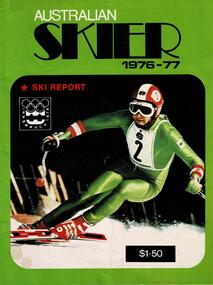
Magazine - Australian Skier 1976-77
... at both Perisher Valley and Falls Creek in the 1970s.... at both Perisher Valley and Falls Creek in the 1970s. This item ...This magazine documented activities and images from the Australian Ski Industry. Its editor, George Stock was an Instructor at both Perisher Valley and Falls Creek in the 1970s.This item is significant because it documents developments in skiing in Australia.A publication featuring a coloured image on the cover. Includes a selection of articles about skiing in Australia. The cover of this issue features the symbol of the Innsbruck Olympic Games.australian ski magazines, australian skier -
 Falls Creek Historical Society
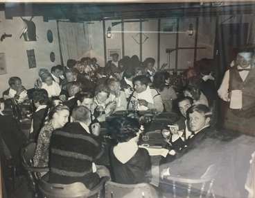
Photograph - Tom Jones Night, Koki 1968
... George Shirling arrived in Falls Creek in 1962. He engaged...George Shirling arrived in Falls Creek in 1962. He engaged ...George Shirling arrived in Falls Creek in 1962. He engaged Phil Nowell to build the original Koki Alpine Lodge which opened in 1965 with 14 beds. George operated the lodge with Michael “Baldy” Blackwell as manager. He also graduated in sport psychology in 1981 and was invited to become team psychologist for the Australian Winter Olympic team which went to Albertville, France, in 1992. He later owned the Red Onion Chalet. George credited the success of Koki to “Baldy” Blackwell. “Baldy” and Phil Nowell started the Trackers Mountain Lodge in partnership during the 1980s. In 1971 George sold Koki Lodge to Sigi Doerr. Sigi was a long time resident of Falls Creek, owning and operating Koki Lodge for many years with his wife, Lee. He was Falls Creek CFA Captain from 1995 until 1998 although he served in the Fire Brigade for much longer. Sigi had many involvements in the community. In 2023 the renamed Koki Alpine resort remains a highly popular destination in Falls Creek.This item is significant because it shows an entertainment event at a well-loved Falls Creek Lodge.A framed black and white photograph of guests enjoying "Tom Jones Night" at Koki Lodge in 1968. Guests include:- Foretable - George Shirling, Geoff Henke, Gweneth Henke (Maloney) who competed in figure skating in the Oslo Winter Olympics 1952, Sigi Haberzetti, Phyllis Bridgford, Bill Bridgford (back to camera)koki lodge, george shirling, sigi doerr -
 Wodonga & District Historical Society Inc
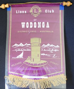
Banner - Lions Club of Wodonga
... In semi-circle below Water Tower: Melbourne/ Falls Creek/Lake Hume.../ Falls Creek/Lake Hume/ Snowy Mountains/ Sydney A small purple ...Leslie William Cole was born on 31 January 1920 in Albury, the first child of William James Cole and Gwendoline Fair. Les spent most of his childhood living with his grandparents in Bethanga, Victoria. In 1934 when he finished school, Les moved into Wodonga. His first job was at Mates Timber Yard. He later worked for Mylons of Wodonga driving taxis and buses. In 1939 after completing militia training, Les applied to enlist with the RAAF and eventually trained as an Aircraft Mechanic. He was posted to the 6th Squadron, serving in Port Moresby, Milne Bay and Goodenough Island before returning to the RAAF base in Sale, Victoria. On discharge. Les returned to Wodonga and resumed working with Mylons. After a range of jobs, Les and his wife Lorna operated a shop in Ariel Street, Wodonga. In the community, Les was a founding member of Wodonga Lions Club. He also joined the Civil Defence which was a predecessor off the SES. He became the Communications Officer and trained other members. Les became the first Controller of the Wodonga Branch of the State Emergency Service, a position he held for 17 years. The new SES headquarters was named in his honour. In retirement he also worked as a Volunteer Community Driver. Les was also named Wodonga Citizen of the Year in 1984 Les continued living in Wodonga until the age of 103 in 2023, when he moved to Melbourne to be closer to his children. He passed away on 12 December 2023. The Lions Club of Wodonga was chartered in 1965 with 18 Founding Members including Les Cole. Lions Australia was first formed in Lismore, NSW in September and has grown to be Australia’s largest service club organisation.A small purple and gold fringed banner with the emblem of Wodonga Lions ClubAt the top centre: The logo of Lions International Across the centre of banner: Lions Club of Wodonga / District 201C Australia In semi-circle below Water Tower: Melbourne/ Falls Creek/Lake Hume/ Snowy Mountains/ Sydneyles cole, wodonga lions club, lions international -
 Falls Creek Historical Society
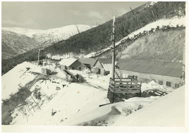
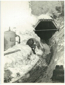
Photograph - No. 1 Headrace Tunnel, Kiewa Hydroelectric Scheme Workshops, 1952
... MEYER COLLECTION - FALLS CREEK PHOTOS In 1947 a determined...Falls Creek Historical Society Slalom Street Falls Creek ...MEYER COLLECTION - FALLS CREEK PHOTOS In 1947 a determined group of like-minded State Electricity Commission (SEC) staff including Ray Meyer, the chief surveyor of the Kiewa Hydro-Electric Scheme, had a common interest that revolved around the skiing potential of the snow-covered high plains which included what is now the resort of Falls Creek. The six SEC employees, Toni St Elmo, Ray Meyer, Jack Minogue, Lloyd Dunn, Adrian Ruffenacht and Dave Gibson (together with their families) banded together to secretly build a 'hut' that was the first ski lodge at Falls Creek. Using a road built in 1930s to gain access to Falls Creek, their hut project was carried out in secret as efforts by other skiers were blocked by H.H.C. Williams – the engineer in charge of the Hydro Scheme. In 1946 Ray Meyer made a trip to the Lands Office in Melbourne. He came away with a 99-year lease on three acres that was ideally suited for a hut designed by Lloyd Dunn. Adrian Ruffenacht (Design Engineer for the KHS) had suggested where the group should build because of easy access to a spring for water. Much of the building material required was scavenged from derelict huts on the high plains. Due to the need for secrecy, the determined group worked on the hut in the evenings and weekends to avoid detection. During the building period the group had met at Echidna Rock (now known as Eagle Rock) where Skippy St Elmo announced, "This is my favourite ‘Skyline’.” And so the first lodge in the area at Falls Creek Ski Resort came into existence. With the development of the International Poma in the 1970s, the Skyline Lodge, which was sited between the ski-lift’s pole one and pole two, was demolished. However, the legacy of Ray Meyer, Toni St Elmo, Jack Minogue, Lloyd Dunn, Adrian Ruffenacht and Dave Gibson and Skyline lives on in the vibrant atmosphere of Falls Creek Resort. The MEYER COLLECTION documents developments on the Kiewa Hydro Scheme and their life at Falls Creek from the mid 1930s to 1950s.This image is significant because it documents development of the Kiewa Hydroelectric Scheme.A black and white image of the No 1 Headrace Tunnel, Kiewa Hydroelectric Scheme showing workshops and the McKay Aditkiewa hydroelectric scheme, ray meyer -
 Falls Creek Historical Society
Photograph - No. 1 Headrace Tunnel, Kiewa Hydroelectric Scheme, 1952
... MEYER COLLECTION - FALLS CREEK PHOTOS In 1947 a determined...Falls Creek Historical Society Slalom Street Falls Creek ...MEYER COLLECTION - FALLS CREEK PHOTOS In 1947 a determined group of like-minded State Electricity Commission (SEC) staff including Ray Meyer, the chief surveyor of the Kiewa Hydro-Electric Scheme, had a common interest that revolved around the skiing potential of the snow-covered high plains which included what is now the resort of Falls Creek. The six SEC employees, Toni St Elmo, Ray Meyer, Jack Minogue, Lloyd Dunn, Adrian Ruffenacht and Dave Gibson (together with their families) banded together to secretly build a 'hut' that was the first ski lodge at Falls Creek. Using a road built in 1930s to gain access to Falls Creek, their hut project was carried out in secret as efforts by other skiers were blocked by H.H.C. Williams – the engineer in charge of the Hydro Scheme. In 1946 Ray Meyer made a trip to the Lands Office in Melbourne. He came away with a 99-year lease on three acres that was ideally suited for a hut designed by Lloyd Dunn. Adrian Ruffenacht (Design Engineer for the KHS) had suggested where the group should build because of easy access to a spring for water. Much of the building material required was scavenged from derelict huts on the high plains. Due to the need for secrecy, the determined group worked on the hut in the evenings and weekends to avoid detection. During the building period the group had met at Echidna Rock (now known as Eagle Rock) where Skippy St Elmo announced, "This is my favourite ‘Skyline’.” And so the first lodge in the area at Falls Creek Ski Resort came into existence. With the development of the International Poma in the 1970s, the Skyline Lodge, which was sited between the ski-lift’s pole one and pole two, was demolished. However, the legacy of Ray Meyer, Toni St Elmo, Jack Minogue, Lloyd Dunn, Adrian Ruffenacht and Dave Gibson and Skyline lives on in the vibrant atmosphere of Falls Creek Resort. The MEYER COLLECTION documents developments on the Kiewa Hydro Scheme and their life at Falls Creek from the mid 1930s to 1950s.This image is significant because it documents development of the Kiewa Hydroelectric Scheme.Two black and white images of the McKay Adit, Kiewa Hydroelectric Scheme' kiewa hydroelectric scheme, ray meyer -
 Falls Creek Historical Society
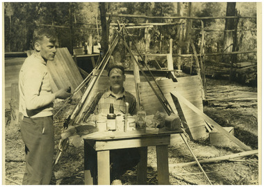
Photograph - Big River Survey Camp, c1949
... MEYER COLLECTION - FALLS CREEK PHOTOS In 1947 a determined...Falls Creek Historical Society Slalom Street Falls Creek ...MEYER COLLECTION - FALLS CREEK PHOTOS In 1947 a determined group of like-minded State Electricity Commission (SEC) staff including Ray Meyer, the chief surveyor of the Kiewa Hydro-Electric Scheme, had a common interest that revolved around the skiing potential of the snow-covered high plains which included what is now the resort of Falls Creek. The six SEC employees, Toni St Elmo, Ray Meyer, Jack Minogue, Lloyd Dunn, Adrian Ruffenacht and Dave Gibson (together with their families) banded together to secretly build a 'hut' that was the first ski lodge at Falls Creek. Using a road built in 1930s to gain access to Falls Creek, their hut project was carried out in secret as efforts by other skiers were blocked by H.H.C. Williams – the engineer in charge of the Hydro Scheme. In 1946 Ray Meyer made a trip to the Lands Office in Melbourne. He came away with a 99-year lease on three acres that was ideally suited for a hut designed by Lloyd Dunn. Adrian Ruffenacht (Design Engineer for the KHS) had suggested where the group should build because of easy access to a spring for water. Much of the building material required was scavenged from derelict huts on the high plains. Due to the need for secrecy, the determined group worked on the hut in the evenings and weekends to avoid detection. During the building period the group had met at Echidna Rock (now known as Eagle Rock) where Skippy St Elmo announced, "This is my favourite ‘Skyline’.” And so the first lodge in the area at Falls Creek Ski Resort came into existence. With the development of the International Poma in the 1970s, the Skyline Lodge, which was sited between the ski-lift’s pole one and pole two, was demolished. However, the legacy of Ray Meyer, Toni St Elmo, Jack Minogue, Lloyd Dunn, Adrian Ruffenacht and Dave Gibson and Skyline lives on in the vibrant atmosphere of Falls Creek Resort. The MEYER COLLECTION documents developments on the Kiewa Hydro Scheme and their life at Falls Creek from the mid 1930s to 1960s.This image is significant because it documents development of the Kiewa Hydroelectric Scheme.Two black and white images at the Big River Old Survey Camp.Photo 1 - Breakfast at Big River Left to RIght Ray Meyer, Wal Johnson Photo 2 - Big River Survey Camp at foot of T Spur C 1949, Kiewa RIver Survey Team.kiewa hydroelectric scheme, ray meyer, wal johnson -
 Falls Creek Historical Society
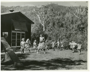
Photograph - Pupils at Bogong School, c1949
... MEYER COLLECTION - FALLS CREEK PHOTOS In 1947 a determined...Falls Creek Historical Society Slalom Street Falls Creek ...MEYER COLLECTION - FALLS CREEK PHOTOS In 1947 a determined group of like-minded State Electricity Commission (SEC) staff including Ray Meyer, the chief surveyor of the Kiewa Hydro-Electric Scheme, had a common interest that revolved around the skiing potential of the snow-covered high plains which included what is now the resort of Falls Creek. The six SEC employees, Toni St Elmo, Ray Meyer, Jack Minogue, Lloyd Dunn, Adrian Ruffenacht and Dave Gibson (together with their families) banded together to secretly build a 'hut' that was the first ski lodge at Falls Creek. Using a road built in 1930s to gain access to Falls Creek, their hut project was carried out in secret as efforts by other skiers were blocked by H.H.C. Williams – the engineer in charge of the Hydro Scheme. In 1946 Ray Meyer made a trip to the Lands Office in Melbourne. He came away with a 99-year lease on three acres that was ideally suited for a hut designed by Lloyd Dunn. Adrian Ruffenacht (Design Engineer for the KHS) had suggested where the group should build because of easy access to a spring for water. Much of the building material required was scavenged from derelict huts on the high plains. Due to the need for secrecy, the determined group worked on the hut in the evenings and weekends to avoid detection. During the building period the group had met at Echidna Rock (now known as Eagle Rock) where Skippy St Elmo announced, "This is my favourite ‘Skyline’.” And so the first lodge in the area at Falls Creek Ski Resort came into existence. With the development of the International Poma in the 1970s, the Skyline Lodge, which was sited between the ski-lift’s pole one and pole two, was demolished. However, the legacy of Ray Meyer, Toni St Elmo, Jack Minogue, Lloyd Dunn, Adrian Ruffenacht and Dave Gibson and Skyline lives on in the vibrant atmosphere of Falls Creek Resort. The MEYER COLLECTION documents developments on the Kiewa Hydro Scheme and their life at Falls Creek from the mid 1930s to 1960s.This image is significant because it documents life in the early years of development of the Bogong High Plains, Victoria.A black and white image of pupils and teacher at Bogong School. Teacher Beverley Hayward. This photo is a newspaper photo published in a Melbourne newspaper at the time (c1949). John Meyer is child third to the right of the teacher.bogong primary school, john meyer -
 Falls Creek Historical Society
Machine - Cash register and ticket machine
... of lift tickets, lessons and packages during the 1990s at Falls...Falls Creek Historical Society Slalom Street Falls Creek ...This Cash Register was used for the sale and production of lift tickets, lessons and packages during the 1990s at Falls Creek. The employees who operated the machine were called 'Ticket Tarts'. This item is significant because it was a critical part of the everyday operation of the chair lifts at Falls Creek.A large square cash and ticket machine with buttons and slots for the production of lift tickets. Long cable connected to the back. snow, ski season, ski pass, ski lessons, ticketing, sales -
 Falls Creek Historical Society
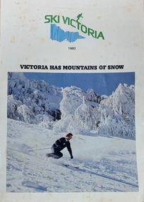
Magazine - Ski Victoria - Victoria has mountains of snow
... . Falls Creek is featured on pages six to eleven. .... Falls Creek is featured on pages six to eleven. This item ...Ski Victoria Booklet from 1980 featuring 48 pages containing all information required for the ski resorts of Victoria. Falls Creek is featured on pages six to eleven. This item is important as it documents seasonal activities at Falls Creek Alpine ResortMagazine with white front cover, featuring a large square image of a person in black and white ski clothes skiing down hill surrounded by snow and blue sky. Centred above image is Ski Victoria in green with a ski figure in same green, a blue vertical line illustration of the state of Victoria. 1980 is written in smaller black letters underneath with Victoria Has Mountains of snow below text and above image in black capital letters. 'SKI VICTORIA / 1980 / VICTORIA HAS MOUNTAINS OF SNOW'skiing, snow field, snow victoria, tourism victoria, ski victoria, snow, winter, winter tourism -
 Falls Creek Historical Society
Journal - Schuss Vol. 24. No.2 March - April 1958
... for Falls Creek General Store. A personal notice on page 51 reports... the development of the ski facilities at Falls Creek. Schuss journal ...Schuss was advertised as Victoria’s Official Ski Journal It was issued monthly from 1935 to 1961 except during the war when summer issues covered two months. This continued after the war, but it averaged 10 issues annually over its 25 year life. Schuss was published by the Ski Club of Victoria which had a membership of 38 Ski Clubs and demanded to be recognised as the prime authority on skiing in the state. The other 30 ski clubs with 85% of the members disagreed and the politics of skiing became heated. These clubs formed the Federation of Victorian Ski Clubs with their own journal, Ski Horizon. With the establishment of the Victorian Ski Association, Ski-Horizon published its last issue in Nov - Dec. 1955 and the role of the official journal was fully taken over by “Schuss”. This item is significant because it contains stories, images and information documenting the development of the ski facilities at Falls Creek.The journal features stories and events chronicling developments in Victoria and internationally. The cover of this issue features a photo of three water skiers taking part in the Moomba Festival in Melbourne, Victoria' Page 45 includes an advertisement for Falls Creek General Store. A personal notice on page 51 reports that Bob Hymans holiday to France with his wife and son.schuss journal, the ski club of victoria, bob hymans, melbourne moomba festival -
 Falls Creek Historical Society
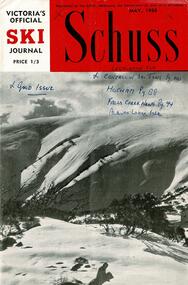
Journal - Schuss Vol. 24. No.3 May 1958
... "Things happening at Falls Creek" written by Shirley Inglis. Page... the development of the ski facilities at Falls Creek. Schuss journal ...Schuss was advertised as Victoria’s Official Ski Journal It was issued monthly from 1935 to 1961 except during the war when summer issues covered two months. This continued after the war, but it averaged 10 issues annually over its 25 year life. Schuss was published by the Ski Club of Victoria which had a membership of 38 Ski Clubs and demanded to be recognised as the prime authority on skiing in the state. The other 30 ski clubs with 85% of the members disagreed and the politics of skiing became heated. These clubs formed the Federation of Victorian Ski Clubs with their own journal, Ski Horizon. With the establishment of the Victorian Ski Association, Ski-Horizon published its last issue in Nov - Dec. 1955 and the role of the official journal was fully taken over by “Schuss”. This item is significant because it contains stories, images and information documenting the development of the ski facilities at Falls Creek.The journal features stories and events chronicling developments in Victoria and internationally. The cover is a photo by Eric Burt captioned "Hotham Ski slopes which are already calling skiers for the '58 season" Page 87 has a brief report about the destruction of the Albury Ski Club by fire on 18th April 1958. The date of the N.E.D.S.A. Junior Championships to be held on Friday 5th September was announced so that school children had time to plan their holidays. Page 94 featured a column "Things happening at Falls Creek" written by Shirley Inglis. Page 125 announced that a second hive of bees had been found in the roof at Skyline Lodge during recent painting. Advertisements for the Falls Creek General Store and the Snow Crystal Inn managed by Milan Kovacic were included.schuss journal, the ski club of victoria, snow crystal inn, albury ski club fire -
 Falls Creek Historical Society
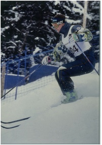
Photograph - Paul Costa in action
... at Falls Creek, attended school there and at Mt Beauty and were...Falls Creek Historical Society Slalom Street Falls Creek ...Paul Costa is the eldest of four brothers who grew up at Falls Creek, attended school there and at Mt Beauty and were members of the Falls Creek Race Club. He originally raced in alpine skiing but changed to mogul skiing at the age of 16. His first event was the Falls Creek Summit Masters, where he finished second in the Open Class. In 1993 Paul Costa placed fourth at the FIS Freestyle World Championships in Altenmarkt-Zauchensee, Austria. He was selected to represent Australia in the Winter Olympics at Lillehammer in 1994, joining his brother Adrian in that team. During his mogul skiing career, Paul Costa collected 26 World Cup starts. At the end of his competitive career he took up coaching junior teams and was part of the moguls coaching staff for the 2006 Torino Olympics.This image is significant because it depicts an Australian Winter Olympian and former member of the Falls Creek Race Club.Coloured image of Paul Costapaul costa, australian olympians -
 Kiewa Valley Historical Society
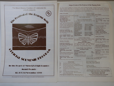
Booklet - Bogong Moth Festival Program x2, The Festival of the Bogong Moth / Official Souvenir Program for 1993
... the festival on the 12, 13 & 14 November 1993 at Falls Creek and Mt..., 13 & 14 November 1993 at Falls Creek and Mt Beauty ...The Mount Beauty Chamber of Commerce Inc. presented the festival on the 12, 13 & 14 November 1993 at Falls Creek and Mt Beauty. The booklet consists of articles and events available over the weekend.Held in the Kiewa Valley in recognition of the aboriginal people who lived and gathered there.A4 pale yellow booklet with 8 pages printed in brown on both sides showing a moth and a mountain in aboriginal style depicted on the cover. bogong moth festival, mt beauty chamber of commerce -
 Falls Creek Historical Society
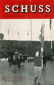
Journal - Schuss Vol. 18. No. 2 March - April 1952
... to the Falls Creek Area in this issue include:- Cover - An image...Falls Creek Historical Society Slalom Street Falls Creek ...Schuss was advertised as Victoria’s Official Ski Journal It was issued monthly from 1935 to 1961 except during the war when summer issues covered two months. This continued after the war, but it averaged 10 issues annually over its 25 year life. Schuss was published by the Ski Club of Victoria which had a membership of 38 Ski Clubs and demanded to be recognised as the prime authority on skiing in the state. The other 30 ski clubs with 85% of the members disagreed and the politics of skiing became heated. These clubs formed the Federation of Victorian Ski Clubs with their own journal, Ski Horizon. With the establishment of the Victorian Ski Association, Ski-Horizon published its last issue in Nov - Dec. 1955 and the role of the official journal was fully taken over by “Schuss”. This item is significant because it contains stories, images and information documenting the development of the ski industry in Victoria.The journal features stories and events chronicling developments in Victoria and internationally. Items related to the Falls Creek Area in this issue include:- Cover - An image of the first Australian Winter Olympic Ski Team entering Bislett Stadium, Oslo during the opening ceremony on the February 15. Standard bearer is Gordon Day, followed by Australian Captain George Chisholm leading the team.schuss journal, australian ski team 1952 oslo, 1952 winter olympic ski team -
 Falls Creek Historical Society
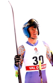
Photograph - Steven Lee at Albertville Winter Olympics, 1992
... up in Falls Creek and had skis on his feet when he was just...Falls Creek Historical Society Slalom Street Falls Creek ...Steve Lee is a three time Australian Olympian who competed at Sarajevo 1984, Calgary 1988 and Albertville 1992. He also achieved 1st in the Furano World Cup Super G in 1985. Steve Lee grew up in Falls Creek and had skis on his feet when he was just two years old. He later became a member of the Falls Creek Race Club and at the age of 14 won State and National Junior titles. After repeated success, Steve was selected to race overseas in the Australian Junior team. He won the Australian Open Championship at the age of 17. For 10 years, Steve never missed a race in the World Cup Circuit. Overall, he claimed 20 top 15 finishes in Downhill, Super-G and combined events. Towards the end of his career Lee swapped the World Cup circuit for the World Pro Tour in the USA, winning the Pro Downhill Tour ‘King of the Mountain’ title. He was also running a photography business in Falls Creek and was also involved in sports commentating on Australian television. This included commentating Alpine Freestyle events at four Winter Olympics and several World Championships. Steve co-founded Chill Factor Ski magazine and spent a decade as a National Selector and President of Falls Creek Race Club. He also became involved in movies, working with Roger Moore and Jackie Chan as a stuntman. As well as these activities Steve started guiding in the mid-90s and established Back Country Tours at his home area in Falls Creek Australia and also in Hakuba, Japan in 2011.This image is significant because it captures an Australian Winter Olympian and pioneer of the Falls Creek Ski community.A colour photo of Steve Lee in his uniform featuring the logo of the Albertville Winter Olympic Gamessteve lee, australian olympians -
 Falls Creek Historical Society
Journal - Schuss Vol. 23. No. 2 March - April 1957
... of Australia's firs ski chair lift by Bob Hymans at Falls Creek.... of construction of Australia's firs ski chair lift by Bob Hymans at Falls ...Schuss was advertised as Victoria’s Official Ski Journal It was issued monthly from 1935 to 1961 except during the war when summer issues covered two months. This continued after the war, but it averaged 10 issues annually over its 25 year life. Schuss was published by the Ski Club of Victoria which had a membership of 38 Ski Clubs and demanded to be recognised as the prime authority on skiing in the state. The other 30 ski clubs with 85% of the members disagreed and the politics of skiing became heated. These clubs formed the Federation of Victorian Ski Clubs with their own journal, Ski Horizon. With the establishment of the Victorian Ski Association, Ski-Horizon published its last issue in Nov - Dec. 1955 and the role of the official journal was fully taken over by “Schuss”. This item is significant because it contains stories, images and information documenting the development of the ski industry in Victoria.The journal features stories and events chronicling developments in Victoria and internationally. The cover features a photograph of a woman watching cattle on Mt Buller in the summer. Page 42 includes an announcement about the success of bookings and key dates of availability for accommodation at Grand Coeur Chalet. Page 52 details the commencement of construction of Australia's firs ski chair lift by Bob Hymans at Falls Creek.schuss journal, the ski club of victoria, bob hymans -
 Vision Australia
Administrative record - Text, Royal Victorian Institute for the Blind annual report 108th 1973-1974, 1970-1971
... , photos of a trip to Falls Creek by students, the success... of a trip to Falls Creek by students, the success of the only ...Articles in the annual report include: the possible acquisition of land at Burwood by the Government for a teacher college, photos of a trip to Falls Creek by students, the success of the only vocationally orientated residential centre for blind adults and the introduction of E.J. Hanlon as President.1 printed volume with photographsroyal victorian institute for the blind, annual reports -
 Upper Yarra Museum
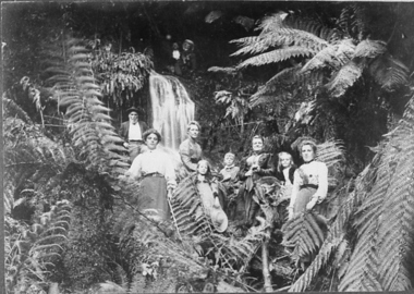
Negative Photographic Reproduction, Jenkins family at Millgrove, 1893, 14.2.1988 (exact)
... or family. ferns millgrove falls jenkin family creek waterfall ...A very popular pastime was to have outings in the bush, with friends or family.Jenkins family at Millgrove, 1893. Negative Black white. Scanned at 600 dpi. This is set amongst Tree Ferns with a small waterfall left of centre, there are 2 men to the right at the top of the falls both with mustache's one with a hat,Below to the Left is Mr Jenkins Senior with a full beard & hands on his hips, in front is a young lady, on the right is another slightly older lady with 2 children a girl in front and boy to her right,and then Mrs Jenkins with a little girl next To her, and her mother to the right.ferns, millgrove, falls, jenkin family creek waterfall -
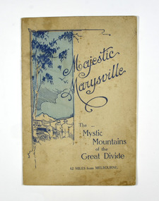 Marysville & District Historical Society
Booklet, Marysville Tourist Association, Magestic Marysville-The Mystic Mountains of the Great Divide, 1920's
... snob's creek falls... cathedral eildon snob's creek falls wolfram mine mt strickland ...An information guide of day trips to attractions in and around Marysville in Victoria. This booklet was produced by the Marysville Tourist Association.Paperback. Cover is beige with a drawing of two people standing next to a car looking at the view. The title is in dark blue across the front.non-fictionAn information guide of day trips to attractions in and around Marysville in Victoria. This booklet was produced by the Marysville Tourist Association.marysville, victoria, marysville tourise association, steavenson falls, keppel falls, cameron cascades, cumberland, mt cathedral, eildon, snob's creek falls, wolfram mine, mt strickland, keppel's lookout, mt kitchener, mt edgar, mt gordon, nichol's lookout, michael dene, beauty spot, gilbert's gully, taggerty river, wood's point -
 Federation University Historical Collection
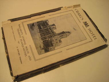
Book, Ballarat Progress Association, Beautiful Ballarat, 1912, 1912
... lal lal falls bo beep creek Soft covered book of eighty pages ...Tourist booklet.Soft covered book of eighty pages. Includes fold out map of Ballarat and illustrations such as Sturt Street, Ballarat Town Hall, Ballarat East Town Hall, Lake Wendouree, Botanical Gardens, statues, Ballarat Grammar School, Ballarat College, St Patrick's College, Ballarat Agricultural High School, Ballarat School of Mines and Industries, Bo Peep Falls, Cobb and Co., Lal Lal Falls.churches, education, schools, gold, ballarat, mining, tourism, railway, craig's hotel, cobb and co, wallace buter factory, the taffy king, eureka stockade, gordon brothers big store, ballarat east town hall, ballarat brewing company, lake wendouree, lake view hotel, ballarat botanical gardens, statues, boer war monument, club hotel, ballarat east gardens, new imperial gold mine, camp hotel, lal lal falls, bo beep creek